Looks Ugly ... Pilot Has Minor Injuries

And I thought someone tried a "Dukes of Hazzard" with a Tesla Cybertruck for a moment.
 
Hmm, Aerovee powered.

Yep ...

In all fairness to Mike Beck (the builder and not the current owner) the plane has been flying for nearly 10 years. He's got a few videos on U-Toob. Appears the new owner has owned it about 6 months ...
 
Nothing wrong with the aerovee itself. Failures due to internal components are exceedingly rare on that motor. I won’t fly behind the aerocarb that powers most of them anymore though. Way too many sonex with engine failures right after takeoff. Even the factory has had two of their aircraft crash after takeoff. None have ever shown evidence of internal engine failures or any definitive cause of the engine stopping. I truely believe that it’s due to the aerocarb. It’s a simple slide body carb but has been made so simple that any slight change in the gravity fed fuel pressure or any even minor interruption of flow like an air bubbble in the fuel line and the engine runs rough or stops. I’m in the process of putting fuel injection on my aerovee because I’m not willing to put my life on the line flying the aerocarb anymore. There is no way the aerocarb would ever make it in the certified world with the way it operates.
 
“To see it tipped over on its back is ferocious almost.”
 
My home field. Don't know the pilot, though.

Ron Wanttaja
Ron, what are the options for landing straight ahead (as preached) in the event of an engine failure at take off, at this airport?
 
Ron, what are the options for landing straight ahead (as preached) in the event of an engine failure at take off, at this airport?
As you might guess, that preys on my mind a bit.

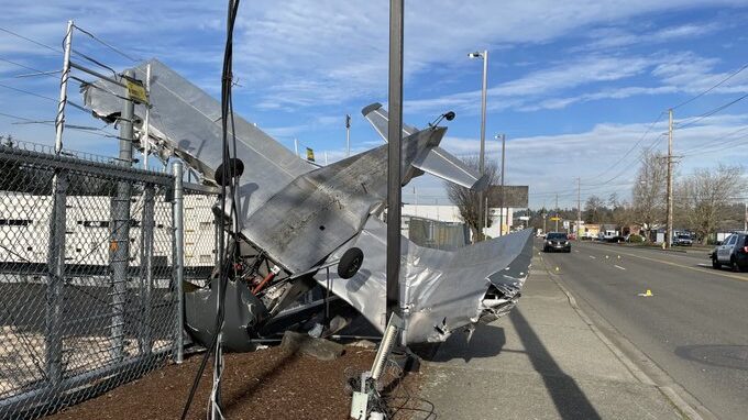
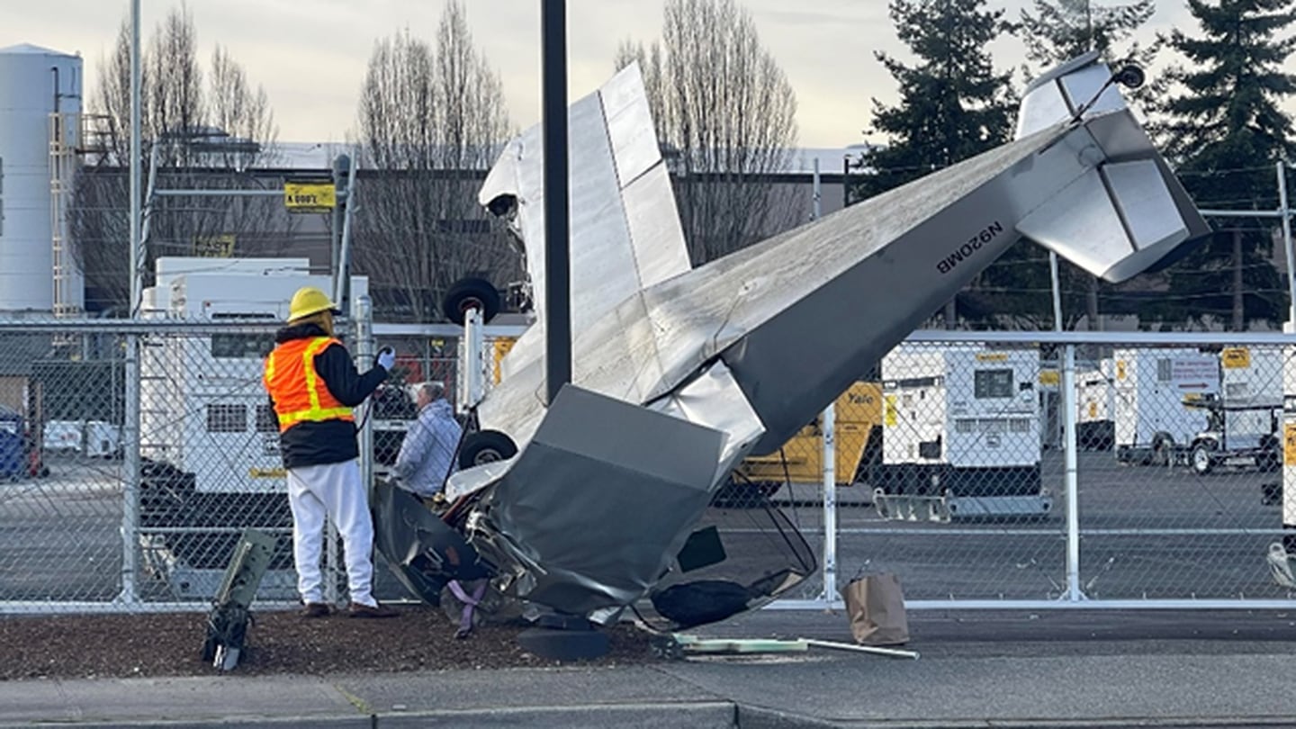
Here's a Google Earth picture of the airport and its environs. The Sonex took off on 34 (up, on the illustration). Approximate crash location is shown by the small red "X". Note that I have no insight into this accident beyond what's been on the local news.
1705542461590.png
A key factor, taking off to the North, is the power lines located about a quarter mile north of the runway. These have factored into previous accidents; several times I've posted picture of a Piper that hit the lines going south and managed to land.

Anyway, when I'm taking off, it's pucker factor until I think I can clear the lines. I'll go under them if I really, REALLY have to. My airplane glides like a manhole cover.

The area is mostly light industrial...warehouses, with service roads between them that aren't, generally, that busy. My own thought would be to try to set down on one of these, but of course, I've got a slow, draggy airplane. Alternatively, the roofs themselves look pretty unobstructed. I'd think I'd line up on one of the roads, and if I had to, slide over and try get an OK3 on a roof. My airplane is moderately light, but I think the local pressure will be too much and I'd expect to go through.

Beyond that, going north, you see a big asphalt parking lot on the upper left. This is a local car-auction place, and the lot is pretty full most of the time. Just south of there (across the road) is a parking lot associated with Emerald Downs Raceway. This is SOMETIMES clear, but they do like to lease it out and sometimes there are things like test tracks for local car dealers. Can't count on it, but worth a glance if the engine is acting up.

Further north, there are little tiny green belts and clear areas. Once you get about 3/4 mile north of the crash site, there' s open farmland.

I do not know if the pilot tried the "Impossible Turn". If he did, he tried to the RIGHT...which, I think, is counter-intuitive in an airplane where the pilot sits in the left seat. It'd be better visibility in a left turn.

There are open areas further east, as can be seen in the above map. I'm think it's more likely that he was trying for there, rather than a full turn-around. The Google Earth image is almost a year old, and it's not inconceivable that there's construction going on there.

Losing the engine taking off to the south is REALLY ugly. All city, to the south.

Whatever the guy did, he came out of it with just minor injuries. It's just about the best any of us could ask.

Ron Wanttaja
 
A little more info and some audio from the accident airplane:

 
Interesting. The video seems to show the takeoff was to the south (runway 1-6) vs to the north as I assumed.

Some oddness here. First, the diagram on the video show the plane on an apparent left-hand pattern for 16. At Auburn, a RIGHT-hand pattern is standard for 16.
1705650722746.png
We'd have to assume he developed engine problems early, and decided to make a left-hand pattern. The problem is, this puts you over a residential area in the city of Auburn. There is a golf course there, but all the other green area you see in the above picture is trees. It's an odd selection, since the area to the west of the airport has more open space.

Here's another Google Earth view of the area when the standard right-hand pattern is flown. The area directly to the south is really covered with buildings (like I said in my previous posting), but the area immediately to the west (e.g., under the standard right-hand pattern) has a lot of open ground. Standard departure to the south includes angling over to the west early to avoid overflying the hospital that's downtown, though it seems only Fly Babies do that.
1705651179516.png
Flightaware data does show the initial departure to the south (N920MB), so it looks like it was a 1-6 takeoff. Flightaware latitudes and longitudes seem to be off, it shows the track being offset about a half-mile to the west and a bit to the south. But it doesn't show the right-hand pattern like the video shows. The pilot flew a local fun flight very similar to those I fly, and came back to the airport and apparently landed. It might be that the Flightaware track quit after a touch-and-go that was followed by a engine issue. Yet the left-hand-pattern path that is shown in the video isn't there on Flightaware.

Auburn is in a weird location. Seattle Center is physically located just ~4 miles east-south-east of the airport, but the airport is in a valley (elevation 65 feet) while Center is at ~410 feet atop the area where the valley cuts through, and set well back from the edge to the valley. When I fly, I don't seem to get painted by the radar until I get to ~500 feet or so. Don't know what that does to the ADS-B Out.

I'm certainly not criticising the pilot's actions (he was there, I wasn't); I'm curious about the source of the path shown on the video.

Ron Wanttaja
 
He may have been planning to depart the pattern to the east or northeast thus the left turnout, then returned when the engine started acting up.
 
When I fly, I don't seem to get painted by the radar until I get to ~500 feet or so.
The nearest long-range radar is at Ft. Lawton (Discovery Park) in Seattle. There’s also the ASR at SEA. You’re still down in the bowl, masked from both of those until, as you said, several hundred AGL.
 
If you takeoff and the engine stumbles most pilots are going to tend to turn left to get back to the airport because that is how the vast majority of traffic patterns are. In a high stress situation people tend to revert to rote instincts. Maybe right was a better option but if you dont think there is time to pause and evaluate you ate going to just do what your instincts tell you to. I listened to the audio and it appears that he lost the engine, it came back as he was trying to get back to the runway and then died again. Thats a pretty high stress situation to stop and try to think through what logically may be the best option.
 
I agree with Dana and kmacht. First deal with the engine, getting it running again makes a good day.

Most familiar pattern is going to be the first choice while dealing with the engine.

The terrain along the river would seem at first, to offer scattered good landing sites, so following the river is a good choice. Ultimately, the engine quit completely, and he was too far from the runway to get there.

I am not too inclined to fault this series of choices. He had a dynamic and changing situation, and the series of choices turned out to less than the best, but no one hurt.

The bottom line, an interesting combination of good and bad luck, mixed with tough decisions.
 
If you takeoff and the engine stumbles most pilots are going to tend to turn left to get back to the airport because that is how the vast majority of traffic patterns are. In a high stress situation people tend to revert to rote instincts. Maybe right was a better option but if you dont think there is time to pause and evaluate you ate going to just do what your instincts tell you to. I listened to the audio and it appears that he lost the engine, it came back as he was trying to get back to the runway and then died again. Thats a pretty high stress situation to stop and try to think through what logically may be the best option.
Certainly reasonable. The only thing I'd mention, here, is that the owner had apparently been flying from Auburn for years. He would have been accustomed to the right-hand pattern for 1-6, and certainly aware that the most-open ground would have been in if he had turned in the other direction. Seems to me the instinct would have been to go for the area which seems to offer the best options for setting it down.

On the other hand, in a side-by-side aircraft, the pilot (from the left seat) has a better view to the left of the airplane.

The terrain along the river would seem at first, to offer scattered good landing sites, so following the river is a good choice. Ultimately, the engine quit completely, and he was too far from the runway to get there.

I am not too inclined to fault this series of choices. He had a dynamic and changing situation, and the series of choices turned out to less than the best, but no one hurt.

The bottom line, an interesting combination of good and bad luck, mixed with tough decisions.
I'm reluctant to be this blunt, but I guess I have to. I am *not* questioning the pilot's choice to fly a left-hand pattern...IF HE INDEED DID. I'm questioning the accuracy of a third-party video that shows a precise path that differs wildly from the ADS-B record as depicted on Flightaware, in an area with known uncertain radar coverage. I'm trying to reconcile that.

Ron Wanttaja
 
He may have been planning to depart the pattern to the east or northeast thus the left turnout, then returned when the engine started acting up.
This could be a possibility...the Flightaware track shows him heading southeast from the airport on his initial departure. But, again, there are few open spaces for a forced landing on the east side of the runway.

Recently posted a non-related video to Facebook, and on viewing it, realized it illustrates the issue pretty well. Here I am turning final for runway 3-4, probably around 500-600 feet AGL. There's a little yellow star at the end of the runway. You'll notice that if the engine started running rough just after takeoff on 1-6 (toward the camera), there's a mass of buildings close-by the airport on the east side (where the video claims the plane went). The eventual crash location is right about at the tip of the propeller blur.
1705691564779.png
In contrast, here's the view a few seconds later, which shows the areas on the opposite side...warehouses, a racing track, but no housing developments. This is the reason for the right-hand pattern for 1-6, it keeps the planes from overflying a ton of houses.
1705691830956.png
Now, of course, in an emergency, s****w the noise complaints. And, like Dana says, he could have already started turning to the left as the engine started to stumble, and, as I've mentioned, his best visibility is going to be to the left. If he indeed flew a left-hand pattern here, I'll shut up. But from the Flightaware track, it looks more to me like engine problems started while he was over the eastern plateau, and immediately turned to go back to the airport.
1705692406446.png
Now, there are definitely problems with the Flightaware presentation, such as the track being offset about a half-mile from the actual runway and the last point shown being considerably south of the actual crash location. I've seen that same offset in my own ADS-B tracks. And maybe Flightaware did miss the climbout from a touch-and-go, with engine problems developing.

But if there's data somewhere that I can use to validate that track shown on the Flight Records video, I'd appreciate it if someone could point me at it.

Ron Wanttaja
 
Last edited:
Ok, queried the host of the video with the same questions I raised here. Interestingly, the pilot himself responded.

He confirmed the video was wrong.... he'd taken off TO THE NORTH (not south, like the video shows) and lost his engine approaching the huge set of power lines north of the airport. He had been trying to reach the clearing to the east that I'd mentioned, but wasn't able to make it.
1705893127553.png
Injuries not too bad. Sore back, no problems found in a CT scan.

He also confirmed that there WAS no ADS-B track on the day of the accident. The track I found was from his previous flight.

Ron Wanttaja
 
Last edited:
Nice detective work, Ron.

Pretty certain an attempt to return to the airport would have been the worst choice.

Congratulations for a good choice that did not quite make it, but was survived.

I hope that you gave him a couple of pats on the back for his outcome? I feel very sorry for the loss of his plane.
 
Thanks so much for the info you have dug up by your hard work and determination. I fly a Sonex (no Aerovee for me) and it concerns me when one of these go down. Really good to know the pilot fared even better than first suspected.
 
The real flight profile is pretty much what I’ve always figured I’d do if I lost the engine over the power lines in the Fairchild. That field always looked survivable. I’m only at 450’ AGL and still at Vy at the power lines; not much energy to spare. Always feel better when I’m turning downwind and start picking up some better options.

Glad to hear the pilot’s ok. Auburn Way would not be my first choice of a landing site.
 
Auburn isn’t quite the safest place to have to force land. A bit like climbing out of 33 at Harvey. He did a good job and credits a 4 point harness for his survival. If you don’t have a shoulder harness…get one.
 
Last edited:
Auburn isn’t quite the safest place to have to force land. A bit like climbing out of 33 at Harvey. He did a good job and credits a 4 point harness for his survival. If you don’t have a shoulder harness…get one.
Threw this together from another of my in-flight videos. The power towers are barely visible, and I sketched a yellow dashed line across where they run. The picture was taken at, roughly, the point where the Sonex developed power issues.
1705949597512.png
As one can see, not a lot of options. There's a great road right under the airplane, but it's bisected by the power lines and the road ends not that far away (and crosses a pretty busy east-west street).

I've marked the field the pilot was heading for, the same one Brian mentioned. Ironically, I didn't realize that field was there. It is beyond the gliding range of my airplane, should my engine quit at about the same place as the Sonex's. I tend to turn crosswind not long after passing over the power lines. Points me at other fields.

I've posted this graphic multiple times, but it probably bears repeating:
1705949949793.png
It's based on homebuilt accidents over a ten-year period. IF THE PILOT RETAINS CONTROL OF HIS AIRPLANE, he's got an average survival rate of 89%. Even in what most would consider a worst-case scenario (landing into buildings) the survival rate is 75%.

But if the pilot tries too hard and stalls out, trying to reach a better spot...there's only a 39% survival rate.

So you can look at my pictures and say, "Well, maybe he could have reached this spot of green," or "That car is pulling out of its parking spot, would have been a perfect place to set down". But damn, the man kept control all the way down and literally walked away from the landing. Sadly, the airplane is totaled, but by my lights, the he did everything right.

Ron Wanttaja
 
Seattle Center is physically located just ~4 miles east-south-east of the airport, but the airport is in a valley (elevation 65 feet) while Center is at ~410 feet atop the area where the valley cuts through, and set well back from the edge to the valley. When I fly, I don't seem to get painted by the radar until I get to ~500 feet or so. Don't know what that does to the ADS-B Out.
For the benefit of the lurkers, the location of Seattle Center is immaterial. What matters is the location of the radar antennas and the ADS-B antennas. The B in ADS-B stands for broadcast, so even, or maybe especially, if the radar is out or not received by the aircraft, the aircraft ADS-B still spits out its location once a second.

What matters is anyone listening? Nearby aircraft may get the signal, if they're listening to the same ADS-B band that the aircraft has chosen. Both FAA and independent ground stations may hear the signal... FlightAware and others combine the FAA and independent receiver data to generate their reports.

Others here have commented on the radar locations. I don't know is there's an FAA ADS-B receiver nearby, or how many independent receivers might be in the neighborhood.

Paul
 
Back
Top