Looking for a few GA pilots willing to test a preflight weather tool I've been building

1kashtanov

Filing Flight Plan
Joined
Oct 8, 2026
Messages
18
Display Name
Daniil
Hi everyone,

I'm an independent software developer, not a pilot, and I've been working on a project called Jaffby.

It's an AI-assisted tool for reviewing weather along a planned GA flight route. You enter your flight details, and it looks at relevant weather information, including forecasts, winds, PIREPs, and how conditions relate to your planned route, altitude, and timing.

The idea isn't to replace a proper weather briefing or make go/no-go decisions for pilots. I'm trying to build something that can act as a second set of eyes, potentially pointing out weather information worth a closer look. You can also inspect the underlying data and calculations behind its findings.

But here's the thing: I've built and tested a lot of it myself, and I'm not a pilot. So I really need feedback from people who actually fly.

I'm looking for a few U.S. GA pilots who would be willing to spend 5–10 minutes trying Jaffby with a hypothetical upcoming flight, or just use one of the example flight prompts already built into the website.

I'd love to hear what you genuinely think. Does it identify anything useful? Does it miss something obvious? Is the output confusing or inaccurate? Or does it simply not add anything compared to the tools you already use?

Negative feedback is absolutely welcome. I'm not trying to convince anyone that AI belongs in every part of aviation. I'm trying to find out whether what I've built is actually useful.

It's free to try, and it's an experimental planning aid, not a substitute for official weather briefings or pilot judgment.

Website: jaffby com

Thanks to anyone willing to take a look. I'd really appreciate your perspective.
 
the need to enter climb/descent rates doesn't make sense when asking for weather. Some graphical depictions would be nice. The all text is ... a start
 
I don't enter websites that force me to accept cookies before i view them because you don't know what the "click" is really doing. Unless I know for sure the company is legit and I really need to get to the site. So, I was going to check out your website but this also is a first post from you so I left with looking at it.
 
What are you using as source data? NOAA had some recent problems with 5G interfering with moisture detection in the air and then took a huge hit with DOGE drastically reducing both staff and available resources. Most weather forecasts ultimately come from government data, so, what are your vulnerabilities here?


Then some thoughts while written to broader efforts of AI, applicable in what we already have:


Is your system open? Data in, sure, how about adapting and correcting? If so, upon what? In an aviation sense, something I am keen to keep eye upon is METARs versus what the TAFs for their current times said. Gives me a sense of how reliable I view the later TAF lines. But these are only looks at individual forecasts, not a look at a forecaster.


the need to enter climb/descent rates doesn't make sense when asking for weather. Some graphical depictions would be nice. The all text is ... a start

Though I see what you mean; climb and descent rates if we’re not going to the stratosphere really is getting too precise. After all, if I say I’ve going at two, is that really two, or two-forty, or perhaps one-thirty. And how precise is the weather itself. Would also think perhaps rather than query an altitude, maybe recommend one.

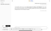
IMG_1813.jpeg
 
Not sure I like it telling me what my main concern should be; I have multiple concerns. To survive, we need to view threats in parallel. Also don’t like it telling me ceiling and vis are not concern but icing is while I gave it a VFR altitude.

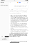
IMG_1814.png

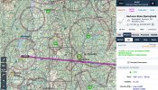
As I gave it a VFR, and as there appears to be a ceiling that will be of concern given the terrain, perhaps it could recommend different times for better travel? And/or a dogleg southerly route? Though this in of itself suggests a disagreement as to what Jaffby provided me and what I am deriving from ForeFlight. Also, while Jaffby mentioned departure and destination wind gusts, I think it should draw more attention to them.

IMG_1815.jpeg

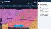
Given the winds, despite expiring a minute before my flight and being fifteen hundred above my flight, I think that turbulence AIRMET should be getting consideration.

IMG_1816.jpeg

I’m sure there is more, but we can get some initial refinements and updates in your AI modeling and training then look again.
 
the need to enter climb/descent rates doesn't make sense when asking for weather. Some graphical depictions would be nice. The all text is ... a start
Thank you for your feedback, I just think that climb and descent periods are helping to create a more accurate trajectory of the flight. These values are not needed to be specified every time you ask a question, when you're already logged in and specified these parameters in your aircraft profile, as well as cruise true airspeed , so bsically when you're logged in you can just ask questions like that: "KAPA to KFNL in 3 hours at 7500 ft msl". Regarding graphical depictions, I'll think about it as well, just focus is a bit different, more on filtering, aggregating and distilling all the relevant weather information for specific routes for AI reasoning assistance. May I ask you also what flight you asked Jaffby about please?
 

Attachments

  • 1792254961404.png
    1792254961404.png
    95.5 KB · Views: 2
I don't enter websites that force me to accept cookies before i view them because you don't know what the "click" is really doing. Unless I know for sure the company is legit and I really need to get to the site. So, I was going to check out your website but this also is a first post from you so I left with looking at it.
Thank you for your reply, yes I understand your concerns, maybe to provide more trust about myself, you can check out my instagram profile, have been posting there my whole path of creating this project, all the problems i faced, how i resolved and how i was building it as well, instagram username: 1kashtanov
 
Not sure I like it telling me what my main concern should be; I have multiple concerns. To survive, we need to view threats in parallel. Also don’t like it telling me ceiling and vis are not concern but icing is while I gave it a VFR altitude.

View attachment 155758

As I gave it a VFR, and as there appears to be a ceiling that will be of concern given the terrain, perhaps it could recommend different times for better travel? And/or a dogleg southerly route? Though this in of itself suggests a disagreement as to what Jaffby provided me and what I am deriving from ForeFlight. Also, while Jaffby mentioned departure and destination wind gusts, I think it should draw more attention to them.

View attachment 155759

Given the winds, despite expiring a minute before my flight and being fifteen hundred above my flight, I think that turbulence AIRMET should be getting consideration.

View attachment 155760

I’m sure there is more, but we can get some initial refinements and updates in your AI modeling and training then look again.
The functionality is pretty limited nowadays, you can check the data sources behind jaffby here: https://jaffby.com/help......in Data Attribution block. Nowadays Jaffby can only analyze the routes you're providing it, it can't recommend you to fly around some bad weather conditions, it's still very early stage, for now I'd like it to perform just one job very well - provide useful feedback regarding weather along the route in a simple readable way, I'll go through your other remarks in more detail on Monday and give you a more detailed feedback. Thank you for your reply anyway, highly appreciate it! May I ask you what you think about the whole concept in general? I'm talking about learning about weather along the coming flight in a conversational matter using AI assistance in one way or another. Does it have a chance to simplify pilots' lives or may only complicate them?
 
Not sure I like it telling me what my main concern should be; I have multiple concerns. To survive, we need to view threats in parallel. Also don’t like it telling me ceiling and vis are not concern but icing is while I gave it a VFR altitude.

View attachment 155758

As I gave it a VFR, and as there appears to be a ceiling that will be of concern given the terrain, perhaps it could recommend different times for better travel? And/or a dogleg southerly route? Though this in of itself suggests a disagreement as to what Jaffby provided me and what I am deriving from ForeFlight. Also, while Jaffby mentioned departure and destination wind gusts, I think it should draw more attention to them.

View attachment 155759

Given the winds, despite expiring a minute before my flight and being fifteen hundred above my flight, I think that turbulence AIRMET should be getting consideration.

View attachment 155760

I’m sure there is more, but we can get some initial refinements and updates in your AI modeling and training then look again.
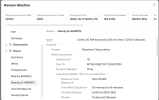
Coming back with a reply, yesterday had a very strong headache, on this screenshotView attachment 155759 I see KLEB TAF 19 nm away from KVSF. Which is okay, though as I understand on jaffby you asked about this route: KCON-KGFL at two this afternoon.....And Jaffby provided to you METARs and TAFs of both KCON and KGFL airports, you can check it by opening tool result, AI made its analysis on top of: 1792313339243.png......So I don't really understand the relevance of this screenshot to the route you requested on Jaffby, maybe I don't understand something - then correct me please, thank you. Now regarding the moment related to not showing an AIRMET even though it's only 1500 ft above the flight, this is a question of discussion, basically right now jaffby filters our nearby AIRMETs or G-AIRMETs using this filtering: 20 NM horizontal, 90 min time, 1,000 ft altitude......So since 1000 ft altitude is less than 1500 ft altitude, this airmet fell out of filtering, but that's why your feedback matters for me, cause maybe I need to increase this 1000 ft altitude margin to a bigger value like 2000 ft for example, again it can be verified if you clicked on the Tool Used: Review Weather button right below the AI response, you would've seen this: 1792313666994.png..............So yeah I agree maybe this limit should be increased for altitude margin to a bigger value, I just don't really have ForeFlight subscription, so have to learn everythign on my own, but really appreciate your feedback, every correction makes the service better i guess!
 
20 NM horizontal, 90 min time, 1,000 ft altitude......So since 1000 ft altitude is less than 1500 ft altitude,

Ranges and proximity aren’t always the whole picture; terrain matters. You can have very close places with vastly differing weather while you can have some further apart that are very similar in condition. Can’t tell you how many times north side of the HRBT (KLFI-KNGU) would be foggy while south side clear. Similarly, if you look at KIZG, nearest TAF is KHIE but that is the other side of the mountains. KPWM is reasonably close but it is coastal while KIZG is still rugged and up. You can also have places with interesting “localized” phenomena. Maybe in the nozzle of a convergence. See Walker Pass near KIYK. Note KIYK itself can be pretty sheltered though the air overtop rather extreme. Then again I’ve seen forty knot wind shifts at KIYK. Or underneath the apex of a wave. KEDW as example, can have light winds out of the east while above and around are strong westerlies. KTSP closest KWJF TAF and that makes no sense. But KMHV and KBFL aren’t fits either. If you’re gonna have AI, you could start looking for where trends with where so as to realize better fitting TAFs to places rather than nearest as other stuff presently does. And spots that make for regular outliers in certain conditions. Matching (and contrasting) would be done in METAR to METAR so as to suspect which TAFs would more align as well as how some might skew.
 
I am interested in taking a look at this. I am a VFR pilot and I am for planning VFR flights 7-14 days in advance. I believe that with the weather tools available it should be possible to pick good VFR weather up to two weeks in advance. Why? So you can plan VFR vacation flights knowing if VFR weather will be available when you plan to come home from your trip. It would be interesting to see if your program meets this need.
 
I am interested in taking a look at this. I am a VFR pilot and I am for planning VFR flights 7-14 days in advance. I believe that with the weather tools available it should be possible to pick good VFR weather up to two weeks in advance. Why? So you can plan VFR vacation flights knowing if VFR weather will be available when you plan to come home from your trip. It would be interesting to see if your program meets this need.
There is no 7-14 day forecast that's anywhere near accurate enough to make a go/no go decision. The App has nothing to do with it.
 
There is no 7-14 day forecast that's anywhere near accurate enough to make a go/no go decision. The App has nothing to do with it.
Yeah, I guess it's kinda difficult to predict 7-14 days in advance, Jaffby is focused on the next 30-40 hours basically, the closer the date of departure the more weather advisories there and the better weather analysis you can get, so Jaffby can't really help with the flights outside of that time window.. I guess in general the weather is more predictable the closer the datetime of departure is to the moment now.
 
Yeah, I guess it's kinda difficult to predict 7-14 days in advance, Jaffby is focused on the next 30-40 hours basically, the closer the date of departure the more weather advisories there and the better weather analysis you can get, so Jaffby can't really help with the flights outside of that time window.. I guess in general the weather is more predictable the closer the datetime of departure is to the moment now.

You can make a no-go decision thirty hours out but you cannot make a go decision thirty hours out, you either decide no or delay the decision for later.
 
There is no 7-14 day forecast that's anywhere near accurate enough to make a go/no go decision. The App has nothing to do with it.
You and I disagree here. In my 2013 article I laid the groundwork for 7-day VFR weather planning using the weather tools available back then. Windy takes that concept out to 12 days. There are a few key principles involved but the premise is it is relatively easy to identify bad VFR weather windows 1-2 weeks in advance, subject to adjustments as time approaches. That means good VFR windows can also be predicted allowing for leeway of about +/- 1 day or so. As the day of the flights approach fine tuning allows planning your VFR trips to keep away from unacceptable weather. I started this because our visits with family revolved around being able to fly home in good weather after spending several days away. I now I only fly if there is high probability of good weather coming back. In 20 years I have only missed my return window once. I have often ruled out flying in favor of driving because my return trip could not be completed VFR. This system predicts return VFR probability with a high degree of accuracy.

 
Last edited:
We do indeed. Windy and several other models have forecasts out to 14 days. That doesn't make them accurate. A lot depends on where you are located and what season. Summer in FL, the forecast is useless from 1 to 6 pm same day due to pop up thunderstorms. Upper plains states with flat land, the longer term forecast can be more accurate regarding the movement of large frontal systems. 7 day forecast, plus/minus a day or two, I agree can be useful in the right conditions and geography. 14 day is like forecasting winning lottery numbers.
 
A SIMPLE CHALLENGE:

Pick a XC flight that you have flown and start looking at the flight plan weather 7 days in advance. Write down if the prediction is GO or NO-GO. if you have Windy, take it out to 12 days. Make a table with a line for today's date across the top, and each added line is the next date for 24 days, 24 lines. Then make 7 columns down, the first column is today and each additional column is 1 day in advance. If you are using Windy then make 12 columns. Now check today's weather. Put down an X if it is NO-GO. put down a Y if it is GO, and leave it blank if it is maybe. Now analyze the weather along your route 7 days in advance, X or Y in each column as predicted. Do this again tomorrow and again each day for the next 24 days. I have done this and I think you will be surprised with the results.

Try it. It is FREE
 
Last edited:
A SIMPLE CHALLENGE:

Pick a XC flight that you have flown and start looking at the flight plan weather 7 days in advance. Write down if the prediction is GO or NO-GO… Do this again tomorrow and again each day for the next 24 days. I have done this and I think you will be surprised with the results.

One problem. You could be successful in your experiment. You need multiple replicate experiments. Even one failure makes it a failed concept. Especially if that failure is of the sort that would have put you in an extreme situation.

Since you said long cross country, are you following a Dave Snowden “next best thing” or hitting adjacent possibles along the way so as to progress toward a destination not actually getting to the destination? Picking alternate routes to different intermediates and saying you are going? Branch plans are not a go of the original plan. They are their own form of no-go. Is your day-to-day continuum of yes, go actually a set of differing plans? And with it, how much time are you wasting planning?

From your article:
“3. Plan for flexibility into your departure and return dates and choose the day to fly based on the weather, not your schedule. After you have been using the 7-day tool for a while, you will realize that the forecast is usually 80% right, but not always right at the right time. Weather formations change and move over time. The 7-day forecast usually predicts these formations fairly well, but the timetable might be off by a day or so. If it is raining now, and good flying weather is predicted in two days, that good weather might take three days to appear, or it might show up a day early.
You must be able to adjust your flying schedule to meet the weather if you want to fly the trip and be safe. For a family trip that has only one hard date event, (like Thanksgiving) that is probably doable. If there are two or three hard date events, it might not be. We drive the car if there are multiple hard dates that must be met.”

Seems rather contradictory.
 
I have put the 7-day VFR weather planning challenge on its own thread, I don't want to hijack this thread so any comments on this can go on the other thread.

One Miracle at a time!
 
The app I linked to is AI generated. It updates the info as you get closer. It is NOT meant to make a Go/No Go decision 14 days out, but gives you general trends of the big picture with a honing of that data as the date gets closer. It seems pretty good 3 days out for the 300-400 mile XC I have fooled around with.
 
The app I linked to is AI generated. It updates the info as you get closer. It is NOT meant to make a Go/No Go decision 14 days out, but gives you general trends of the big picture with a honing of that data as the date gets closer. It seems pretty good 3 days out for the 300-400 mile XC I have fooled around with.
Have you tried jaffby? https://jaffby.com/
 
Back
Top