N1120A
Pattern Altitude
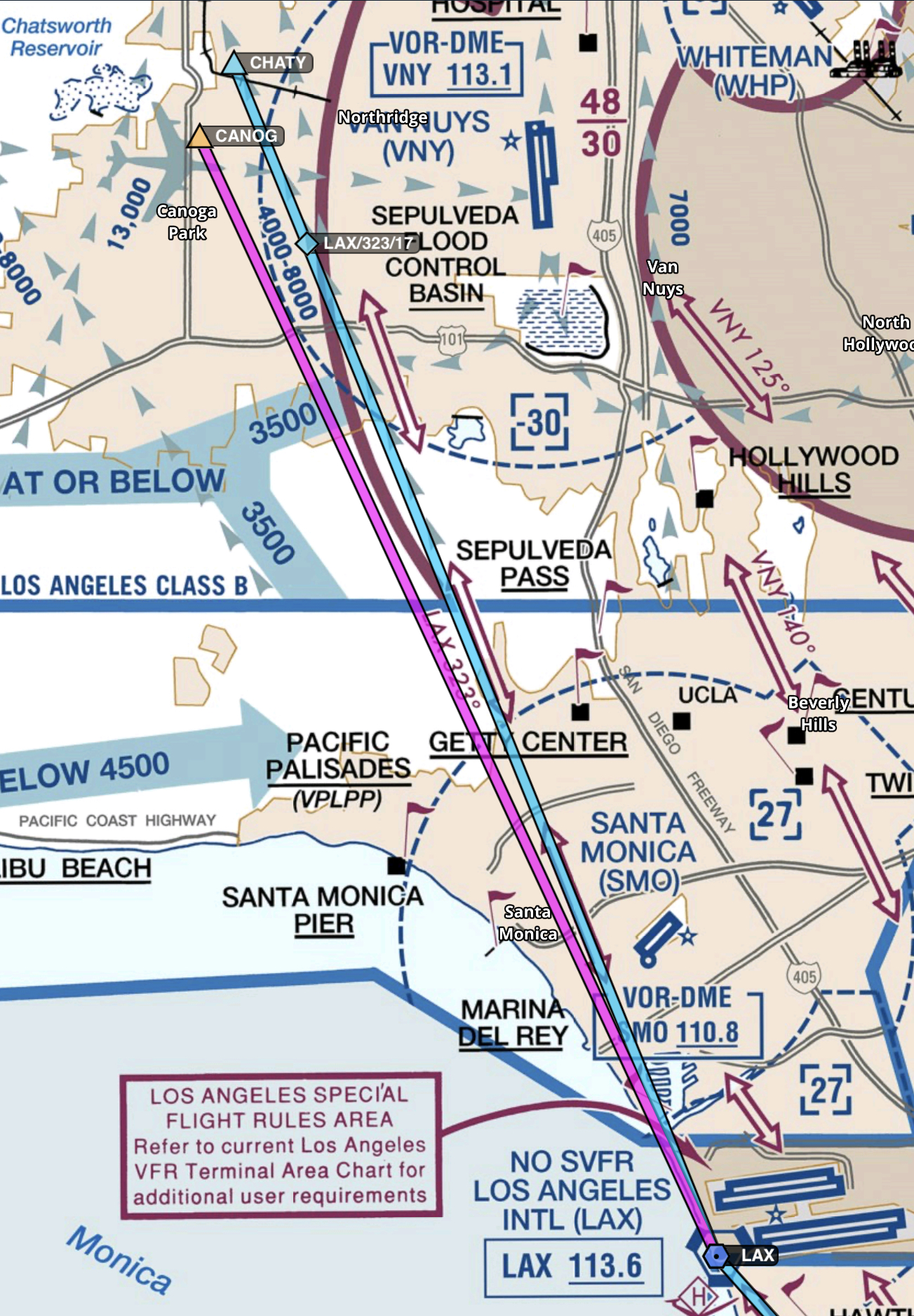
I've done a bunch of transitions through the LAX Class B, due to training and being from around CMA, working in Los Angeles and living in San Diego. As such, the VFR transitions are pretty common to my mission. As some might know, the Mini Route has been suffering a bunch of closures at VFR times lately for reasons only known to the LAX controllers (some are saying they are doing it cause staffing is tight).
Anyway, most people know that the Mini Route is SMO to VPLSR at 2500'. The rest of the routes don't have great explanations of the GPS points for their entry/exits, so I've studied this to maintain as much accuracy and safety as possible. While VOR tracking is something we all must, and should, know, using GPS coordinates is a more accurate way of handling these routes and makes it safer for all of us. I hope this key helps everyone. Indeed, the TAC charts don't do a great job explaining some of the GPS points they use. For example, they use "abeam VPLVT" for the coastal route. If you plug in VPLVT (the Vincent Thomas Bridge), you'll be on the LAX 132, not 123. You are much better plugging in the WILMA intersection.
Mini Route South - 2500', SMO Direct to VPLSR (SMO128 Radial)
Mini Route North - VPLSR Direct to SMO (SMO128 Radial)
SFRA South - 3500' - SMO Direct to PIJIN (SMO132 Radial)
SFRA North - 4500' - PIJIN Direct to SMO (SMO132 Radial)
Coastal Route South 5500' - CANOG to LAX to WILMA (LAX323 LAX LAX123)
Coastal Route North 6500' - WILMA to LAX to CANOG (LAX123 LAX LAX323) (you will turn before
CANOG, but nice to have something to point at).
Coliseum Route South 8500-9500' (assigned) - VNY to STABO to SLI to MIDDS (VNY125/SLI306 to SLI120)
Coliseum Route North 8500-9500' (assigned) - MIDDS to SLI to STABO to VNY (SLI120 to VNY125/SLI306)
Hollywood Park Route South 8500-9500' (assigned) VNY to VPLHF to DRIFY (VNY140 to between VPLQM and FERMY)
Hollywood Park Route North 8500-9500' (assigned) DRIFY to VPLHF to VNY (VNY140 from between VPLQM And FERMY)
I hope this helps. I've seen GPS explanations of these routes to be pretty poor online, except for the Mini Route and the southern part of the Coastal (there is no more Getty Center GPS point, which is weird).
Last edited: