Joaquin

dell30rb

Final Approach
Joined
May 18, 2011
Messages
7,147
Location
Raleigh NC
Display Name
Ren
Home Airfield
KTTA, NC81
Yesterday morning the certainty for Joaquin's path was very low. As the day went on, the various forecast models seemed to indicate a preference towards a stronger hurricane (cat 2) landfall somewhere around VA Beach. This morning it looks a lot more sure, as overnight many of the dissenting models aligned with this idea of an east coast landfall. Looks like I might be skipping the NCSU game this weekend and heading up to VA to pull the boat out of the water.


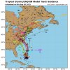
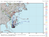
The first pic is from yesterday and the 2nd is from this morning. These are the US model runs only. 4/5 of the major global models agree (3 US, one Canadian) and there is one not pictured, the european model which still sends the hurricane offshore, over Bermuda. The absence of agreement with the last model is probably why the NHS forecast cone is somewhat conservative.

With 2-3 days of soaking rains and gales before it, if this comes true it will be a huge mess for the outer banks /chesapeake/delaware bay

This guy runs a consulting company that does long range forecasts and disaster forecasts for corporations, municipalities and prospectors (energy mostly). He's on Fox business a lot and does a daily video blog. Today's was focused on Joaquin

http://www.weatherbell.com/daily-update---september-30-2015
 

Attachments

  • joaquinspaghetti1.png
    joaquinspaghetti1.png
    228 KB · Views: 29
  • joaquinspaghetti3.jpg
    joaquinspaghetti3.jpg
    63.7 KB · Views: 37
That sucks. Hope the hangars hold up. Ain't no way to fly the biplane west at this point.
 
That sucks. Hope the hangars hold up. Ain't no way to fly the biplane west at this point.

Yeah. The 11am NOAA forecast has it peaking at a Cat 3 72hrs from now. Would you end up going out to sea if it looks like a direct hit?

We have a similar dilemma with the terrible weather forecast from now until the hurricane gets near. If its looking really bad, the nearest yard capable of hauling the 40' sailboat is a 3 hr sail away, and we'd have to sail out into the middle of the bay and round a big shoal in what looks to be a full blown gale.
 
Yeah. The 11am NOAA forecast has it peaking at a Cat 3 72hrs from now. Would you end up going out to sea if it looks like a direct hit?
No, I'm on shore duty now. It's called hunker down and wait it out. They might sortie the fleet though, but I haven't heard anyone freaking out yet.
 
Welcome to our world - Miami, FL. Watching hurricanes, storms, depressions, and waves is a part of life for half the year. Bit early to think you are going to take a hit according to NOAA though certainly not too early to take precautions.

http://www.nhc.noaa.gov/

145429.gif
 
Hope to pass on my boat sale before Saturday. Looking to start south with the plane the weekend,from Ma to Fla,not sure that's going to happen
 
If you look into it a little deeper than just looking at the forecast cone from NHC you can see there are two ideas on what it might do. The US, UKMET and Canadian models all agree that the storm will nail the east coast.

The European model is the outlier, dragging the storm directly out to sea. This model has a history of pulling out underdog victories in situations like this, so the hurricane center is wisely putting out a somewhat middle of the road forecast. I think we'll know tomorrow. The one that takes it out to sea only runs every 12 hours, about 2:30AM and 2:30PM.

This is the best compilation of the models I could find that illustrates both possibilities.

CQKU42TWgAA_ALB.png


The NHC does a pretty good job outlining these two scenarios in the Forecast Discussion. Always read the forecast discussion (the aviation weather FD is a must read any time you are dealing with bad weather). Note that if the Hurricane does take the east-coast path, that a hurricane watch could be up for the continental US in only 36 hours.

1. Confidence in the details of the track forecast late in the
period remains low, since the environmental steering currents are
complex and the model guidance is inconsistent. A wide range of
outcomes is possible, from a direct impact of a major hurricane
along the U.S. east coast to a track of Joaquin out to sea away from
the coast. It is therefore way too soon to talk about specific
wind, rain, or surge impacts from Joaquin in the U.S.

2. Should the threat to the U.S. increase, any further adjustments
of the forecast to the west would likely be accompanied by an
increase in the forecast forward speed, with impacts along the coast
occurring sooner than currently forecast. A hurricane watch could
be required for portions of the U.S. coast as early as Thursday
evening.
 
Last edited:
Insert gratuitous comment about the Spin Zone here....

Seriously, though, there is still a lot of divergence in the models. Add to that the fact that the US model & data collection is not as good as the European model, and there's good reason to not reach a conclusion - yet.

Little doubt that it will soak the east coast. If this takes an inland turn, the hardest hit will be those on the eastern shore of VA/MD, DC, and Baltimore. Great - more hot blowhards hitting DC.

Still worth keeping a close eye on it.
 
Add to that the fact that the US model & data collection is not as good as the European model, and there's good reason to not reach a conclusion - yet.
People who believe that are to be mocked and marginalized as "Joaquin deniers" for putting their medieval beliefs ahead of the overwhelming consensus of climate science ...

:D
 
Again, let me offer Copperhill, TN (1A3) as a port in a storm if anyone wants to evacuate the coast.

Can't promise a hangar, but at about 1,800' should be clear of most of the storm's fury, though we can still get some winds this far inland.

If you head this way, just give me a head's up and I can arrange lodging, either at my digs at Scorpion Hollow or a nearby motel.

[email protected]
 
being unfamilar or having the munchies?

HA! I guess it could be read either way. :lol:

Being unfamiliar with would mean that you have never experienced them ergo you have never used pot. That would be a good thing.... I guess.

Not having the muchies could also be a good thing if you are trying to lose weight.

However, having the munchies gives you a great excuse for making a pig out of yourself.... or so I've heard.

To be honest, it's been 35 years since I might have experienced that effect. No plans to go backwards.

Anyway, back to our hurricane......
 
Back
Top