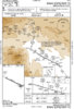
KUDD RNAV Runway 10 is indeed an interesting one. A pilot has to be a moron to arrive via V137 for this approach in a light piston airplane, especially when there is weather of any kind.
I'm assuming you're making a joke about the fix name?
If not... Why? The only thing that looks challenging about this approach to me is the descent gradient, which tops out at 500 feet/nm from CIKUS to FEMAK.
Looking at alternatives, it looks like if you can maintain a constant 419'/nm descent gradient from FETAR all the way into the FAF (JANEN), you'll be above all the fixes in between but arrive at the FAF right on target, and it's 325'/nm in from there.
I'm actually not sure how my plane would do with that. You would likely be at 13,000 MSL to start with, so about 17" MP at WOT. Reducing to 14" (which is as low as I can go without setting off the gear warning) right away at MORON, a bit over a 500 fpm descent would meet the gradient to get to 12,200 at FETAR.
Going down 419'/nm from there would be nearly 1300 fpm to start with, which would probably speed me up a good bit and keep me from getting under gear speed. I'm not sure I could get below gear speed even with speed brakes out at that gradient.
That means that getting down would likely mean dropping the gear right away at MORON. I cruise at about 172 KTAS at 13000, so IAS would be 137 upon reaching MORON and I generally figure that a 500 fpm descent will add about 10 knots. My gear speed is 140 KIAS, so I'd likely plan to drop the gear immediately and keep power at 17" until FETAR, and then reduce as necessary. I might even extend speed brakes and keep power at 17" just to keep the prop from driving the engine the rest of the way in.
Certainly an interesting thought experiment, and something that might be fun to try (just going up to 13,000 locally here and messing with power and drag to see how it works out. It's very different from my normal descent profile, but worth learning before doing an approach like this for real! The RNAV (GPS) Z 19 into KJAC that I shot last summer was a challenge to get down and slow down, and that was only 306'/nm!
After doing this, I'm thinking it makes a lot of sense to calculate a single gradient beforehand and find the altitudes that gradient gives for the approach. It's also worth attempting to fly different gradients with different configurations to see what the plane is capable of. In reality, it'd be even better to find a constant descent rate even though that will curve the descent gradient downward somewhat as you slow down, but that makes the calculation a lot more difficult.
I must have a sickness, because I find this stuff really fun!