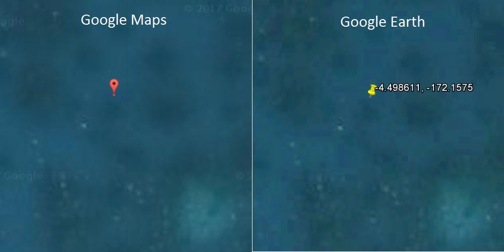
"Image Compression artifacts": another way of saying I see it but don't believe it. If one doesn't see an airframe why not say light-shadow-rocks. Why use a technical term no one understands. What is image compression artifacts anyway?
Just because YOU do not know or understand the term "Image Compression artifacts" does not mean that they do not exist. This is a common term with a meaning that is perfectly well understood by anyone who has even a passing knowledge of digital photography and digital image storage. If you are going to be using digital images for forensic purposes, you had better understand this term, and how to recognize compression artifacts in a photograph.
The issue is that images take up a lot of space on a disk. For each pixel, you need to store the coordinates of the pixel, and the Red/Green/Blue value of the pixel (Or CMYK, or Chroma-Luminance, or whatever method your image format happens to use to encode color) If we just wrote all that data to disk, it would take up a lot of space. So we use use compression. There are two types of compression, lossy and lossless. With lossless compression, the uncompressed data is a faithful reproduction of the original. This is the type of compression which is used with data files - for example ZIP. If you ZIP a word processor document, and then UNZIP it, the content will be unchanged.
However, you can get much higher compression if you use lossy compression. In this case, the uncompressed data is NOT a faithful reproduction of the original, but it is "good enough" for human sensory consumption. Typically music (ex, MP3) movies (ex, MPEG) and images (ex, JPG) use lossy compression. You can even control the level of artifacts when compressing the image, to trade off image quality for space. This is usually "good enough" and you don't notice the changes due to compression when looking at the entire image. However, if you zoom in really far, like you have done int he pictures above, you can clearly observe the effects of compression. In this case, the compression artifacts happen to be vaguely airplane shaped, if you are looking REALLY hard for something that looks like an airplane.
BTW, the type of artifacts visible in the images you shared are known as block boundary artifacts. Go ahead and google for them. I promise, it's not Fake News.