AirDC
Pre-takeoff checklist
I noticed while taking some practice exams this week with both Sporty's (iphone app) and Gleim IFR Knowledge Course that an identical question came up with different correct answers being given by each company.
I emailed both companies, and the chief instructors from each defended their respective answers. Just curious if anyone actually saw this question on the test, and what the actual right answer was. I'm taking the exam on Saturday morning. Other questions like this with unclear answers?
The Question (13. PLT083 IRA)
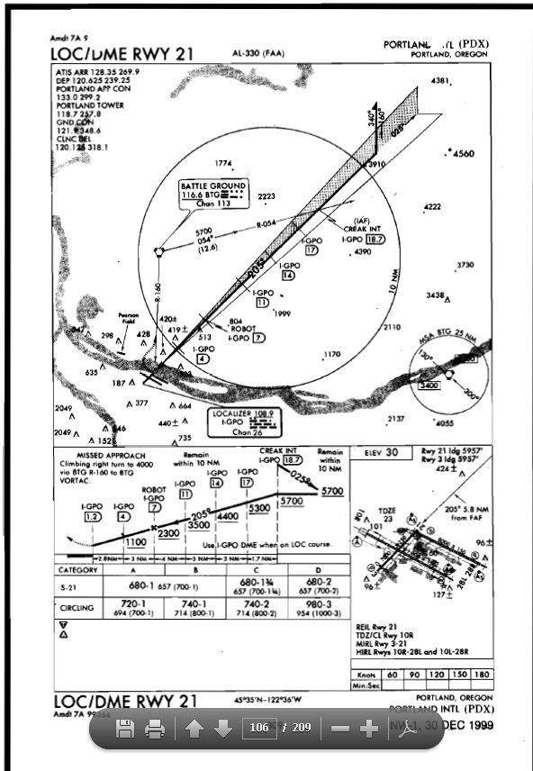
(Refer to figure 49 below) When conducting a missed approach from the LOC/DME RWY 21 approach at PDX, what is the Minimum Safe Altitude (MSA) while maneuvering between the runway and BTG VORTAC?
A - 4,000 feet MSL.
B - 3,400 feet MSL.
C - 6,100 feet MSL.
Gleim Response
Hi Andrew,
I hope you are doing well today.
It is a bit of a trick question. The MSA for that particular area is depicted as 3,400 feet. If the question stated what is the Minimum Safe Altitude for maneuvering between the runway and the BTG VOR than 3,400 feet would be the correct answer. In this case however the question specifies the maneuvering is being conducted as part of the missed approach procedure, which would raise the MSA to 4,000 feet, the lowest altitude permitted for the return to the VOR on the missed approach segment.
Thank you, have a great day, and fly safely!
Scott
Part 141 Chief Instructor
Gleim Internet, Inc.
The correct answer is 3,400’. The circle in the lower right corner of the plan view shows the Minimum Safe Altitude (MSA) around BTG as 6,100' and 3,400'. Since the runway is southwest of BTG, the MSA is 3,400'.
As defined by the FAA in the Instrument Flying Handbook (IFH), the Minimum safe altitude (MSA) is the minimum altitude depicted on approach charts which provides at least 1,000 feet of obstacle clearance for emergency use within a specified distance from the listed navigation facility. There is no mention of it changing based upon where you are in the approach. It only changes based upon the sector where you are in relation to the navigation facility.
Also from IFH: The MSA circle appears in the plan view, except in approaches for which the Terminal Arrival Area (TAA) format is used or appropriate NAVAIDs (e.g., VOR or NDB are unavailable. The MSA is provided for emergency purposes only and guarantees 1,000 feet obstruction clearance in the sector indicated with reference to the bearings in the circle. For conventional navigation systems, the MSA is normally based on the primary omnidirectional facility (NAVAID) on which the IAP is predicated. The MSA depiction on the approach chart contains the facility identifier of the NAVAID used to determine the MSA altitudes. For RNAV approaches, the MSA is based on the runway waypoint for straight-in approaches, or the airport waypoint for circling approaches. For GPS approaches, the MSA center header will be the missed approach waypoint. The MSL altitudes appear in boxes within the circle, which is typically a 25 NM radius unless otherwise indicated. The MSA circle header refers to the letter identifier of the NAVAID or waypoint that describes the center of the circle.
4,000’ is the altitude that the pilot should climb to during the missed approach but it is not the MSA. Mr. Gleim’s instructor is correct in that you would climb to this altitude as part of the missed approach but appears to be confusing the terms. The MSA is the MSA as listed on the approach chart. The missed approach altitude and the Minimum Safe Altitude (MSA) are two different terms and the mention of the missed approach is a distracter used by the FAA. The mention of the missed approach does not make the missed approach altitude the MSA while on the missed approach. They are different things and have different uses as indicated by the MSA definition.
The FAA does not provide correct answers to any of their sample questions. We simply must use the available resources from the FAA to determine the correct answers.
If you have any further questions, please feel free to contact me directly via this Email address.
Best Regards,
Paul
Chief Instructor
ASA Opinion (found via google) - 4,000'
See last question on this PDF
http://www.asa2fly.com/files/updates/TP-I_Update_0612.pdf
I emailed both companies, and the chief instructors from each defended their respective answers. Just curious if anyone actually saw this question on the test, and what the actual right answer was. I'm taking the exam on Saturday morning. Other questions like this with unclear answers?
The Question (13. PLT083 IRA)
(Refer to figure 49 below) When conducting a missed approach from the LOC/DME RWY 21 approach at PDX, what is the Minimum Safe Altitude (MSA) while maneuvering between the runway and BTG VORTAC?
A - 4,000 feet MSL.
B - 3,400 feet MSL.
C - 6,100 feet MSL.
Gleim Response
Hi Andrew,
I hope you are doing well today.
It is a bit of a trick question. The MSA for that particular area is depicted as 3,400 feet. If the question stated what is the Minimum Safe Altitude for maneuvering between the runway and the BTG VOR than 3,400 feet would be the correct answer. In this case however the question specifies the maneuvering is being conducted as part of the missed approach procedure, which would raise the MSA to 4,000 feet, the lowest altitude permitted for the return to the VOR on the missed approach segment.
Thank you, have a great day, and fly safely!
Scott
Part 141 Chief Instructor
Gleim Internet, Inc.
2nd response
All of these questions always come back to the "most right" answer. In this case there is nothing in the regulations, the AIM, or the IFHB that specifically deals with an MSA that is lower than the altitude specified in the MAP. It is however stated in the AIM and the IFHB the MSA depicted on IAP charts is for emergency use and navigation reception is not guaranteed.
Can I find conclusive evidence to back up my answer? No I can not. I do believe that is the answer the FAA is looking for, since there is no mention of anything abnormal in the question. Sporty's may have a different opinion so I would try asking them, I would be interested in hearing how they explain their answer. I would answer 4,000 feet if I was taking the test.
Scott
Sporty's ResponseAll of these questions always come back to the "most right" answer. In this case there is nothing in the regulations, the AIM, or the IFHB that specifically deals with an MSA that is lower than the altitude specified in the MAP. It is however stated in the AIM and the IFHB the MSA depicted on IAP charts is for emergency use and navigation reception is not guaranteed.
Can I find conclusive evidence to back up my answer? No I can not. I do believe that is the answer the FAA is looking for, since there is no mention of anything abnormal in the question. Sporty's may have a different opinion so I would try asking them, I would be interested in hearing how they explain their answer. I would answer 4,000 feet if I was taking the test.
Scott
3rd Response
(redacted a couple paragraphs)
So what should you do if this question comes up on the test? In my expert opinion, I am going to recommend that you flip a coin. I will continue to research the issue and see if I can learn more.
Scott
So what should you do if this question comes up on the test? In my expert opinion, I am going to recommend that you flip a coin. I will continue to research the issue and see if I can learn more.
Scott
The correct answer is 3,400’. The circle in the lower right corner of the plan view shows the Minimum Safe Altitude (MSA) around BTG as 6,100' and 3,400'. Since the runway is southwest of BTG, the MSA is 3,400'.
As defined by the FAA in the Instrument Flying Handbook (IFH), the Minimum safe altitude (MSA) is the minimum altitude depicted on approach charts which provides at least 1,000 feet of obstacle clearance for emergency use within a specified distance from the listed navigation facility. There is no mention of it changing based upon where you are in the approach. It only changes based upon the sector where you are in relation to the navigation facility.
Also from IFH: The MSA circle appears in the plan view, except in approaches for which the Terminal Arrival Area (TAA) format is used or appropriate NAVAIDs (e.g., VOR or NDB are unavailable. The MSA is provided for emergency purposes only and guarantees 1,000 feet obstruction clearance in the sector indicated with reference to the bearings in the circle. For conventional navigation systems, the MSA is normally based on the primary omnidirectional facility (NAVAID) on which the IAP is predicated. The MSA depiction on the approach chart contains the facility identifier of the NAVAID used to determine the MSA altitudes. For RNAV approaches, the MSA is based on the runway waypoint for straight-in approaches, or the airport waypoint for circling approaches. For GPS approaches, the MSA center header will be the missed approach waypoint. The MSL altitudes appear in boxes within the circle, which is typically a 25 NM radius unless otherwise indicated. The MSA circle header refers to the letter identifier of the NAVAID or waypoint that describes the center of the circle.
4,000’ is the altitude that the pilot should climb to during the missed approach but it is not the MSA. Mr. Gleim’s instructor is correct in that you would climb to this altitude as part of the missed approach but appears to be confusing the terms. The MSA is the MSA as listed on the approach chart. The missed approach altitude and the Minimum Safe Altitude (MSA) are two different terms and the mention of the missed approach is a distracter used by the FAA. The mention of the missed approach does not make the missed approach altitude the MSA while on the missed approach. They are different things and have different uses as indicated by the MSA definition.
The FAA does not provide correct answers to any of their sample questions. We simply must use the available resources from the FAA to determine the correct answers.
If you have any further questions, please feel free to contact me directly via this Email address.
Best Regards,
Paul
Chief Instructor
ASA Opinion (found via google) - 4,000'
See last question on this PDF
http://www.asa2fly.com/files/updates/TP-I_Update_0612.pdf


