Icing Go/No-Go insights

tonycondon

Gastons CRO (Chief Dinner Reservation Officer)
Joined
Mar 9, 2005
Messages
15,456
Location
Wichita, KS
Display Name

Display name:
Tony
Its been a fun winter of IFR weather that is very tempting. A nice example was yesterday and today. Yesterday was 1000ish OVC with tops reported around 3000. Temps were below freezing but the AIRMET for ice was well off to our northeast. The Icing Probability forecast on ADDS was indicating somewhat of a chance at 3000 of ice, but less than 50%. After a Cirrus and Bonanza landed with no ice, and a King Air and 182RG departed with no ice, I launched with my PP student and we got on top for a great lesson on instrument work. If it hadn't have been for those pilot reports I probably would've chickened out and done some ground work. Of course playing the conservative card is always a decent option but I dont want to always default to a no-go if the situation is flyable. So I'm wondering what you all use to make the determination? I wonder if I depend too much on the CIP/FIP tool and I'm pretty sure that I probably dont really understand its limitations.

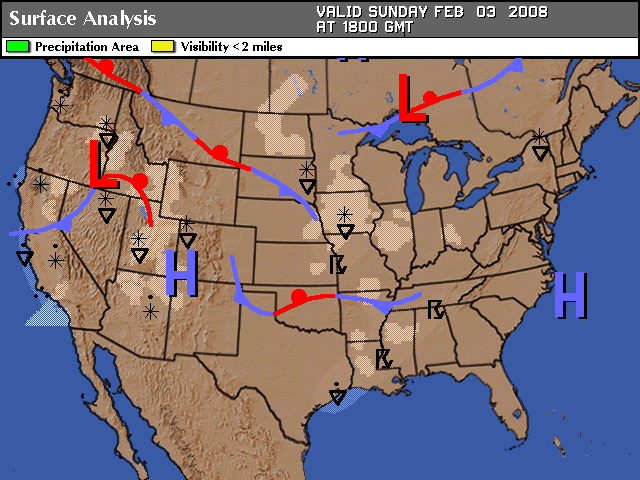
Today is a great example. Chris, Rachel, Leah, and I were hoping to make it to Janesville for breakfast. Here is where the AIRMETs were as in picture 1

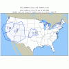
Looking good so far, right? Ceilings en route are IFR at departure to MVFR at destination. There is two pilot reports at Moline for negative icing. This was in an area that, at the time, had an icing potential forecast in the 75%-100% range. No other PIREPS for Iowa or Wisconsin. The FIP for 3000 at departure time is in picture 2.

Departure is looking around a 15% chance of some ice, but Janesville is up in the 75%-100% range. Of course no way to know really if that probability is for a trace of ice or severe.

edit: It changed while I was typing! Departure and Destination are in the 75-100% range. Of course 3000 is right at the top of the clouds - the worst place for ice anyway.

Return trip FIP is picture 3.

Probability at 3000 is below 25% for the entire route. From my looking at this picture it seems like it could be pretty reasonable to climb up to on top and cruise to Janesville. However I would be somewhat concerned about picking something up on the approach in there. After a nice breakfast with PoA friends and some time spent cleaning the leading edges the forecasts indicate to me that another blast up to on top and trip home could be made pretty much ice free. But it turns out that Ames this morning is reporting:

KAMW 031314Z AUTO 14008KT 1/4SM FZFG VV001 M04/M05 A3010 RMK AO2

and the next door ILS's are at:

KDSM 031338Z 14007KT 1/4SM R31/1600V2200FT FZFG OVC001 M04/M04 A3012 RMK AO2 SFC VIS 1/2

KIKV 031335Z AUTO 14006KT 1 3/4SM OVC002 M04/M05 A3011 RMK AO2

so the go/no-go on this trip was Ice Independent.

So what do you all look for when doing your winter IFR planning? Visible Moisture + below freezing temps = no go is not a valid answer for this excercise because obviously there is more to it. I dont intend to be launching every day of the winter and picking up loads of ice. In fact, I dont want to pick up any ice! :no: But I know there are days where the clouds are ice-free even though the temps are below freezing, and I want to learn how to identify those days.
 

Attachments

  • airmets_IC.gif
    airmets_IC.gif
    19.1 KB · Views: 23
  • ice1.bmp
    452.6 KB · Views: 28
  • ice2.bmp
    452.6 KB · Views: 15
Last edited:
Tony, I just got done looking at the Waterloo trip. Not even a legal alternate at KCID or KDSM (500-2).

The ice shelf is but 2500 foot thick but my home drone is not relandable. I can get back in at KPIA but then have to leave it there.

It all says, this AM's session is going to be "weather flying -GROUND SCHOOL".

Sigh.
 
OK bruce, you have basically the same situation as we did. But what if home was relandable and an alternate was available? would it then be a GO?
 
can you help us geographically-challenged and draw your route on one of the charts please Tony?
 
My CFI and I had this same discussion Friday. I flew the H60 early at ALO in the morning in around the local area VFR but seen the thin cloud layer over Manchester. We flew VFR over the top for a while but there were no sucker holes. So we headed back to ALO and I called it a day. On the drive home to DBQ I thought the same thing as your first post. Even though there was no icing reported or forcasted at our altitude...(there was some east and at 30k) we decided to take the conservative route and stay on the ground. The Archer I'm told picks up ice quickly and flys like crap with trace amounts of ice. I'm new at the game of flying without de-ice equipment and have never had it fail on me (yet). It makes it hard to get a little bit of IMC in the winter if you don't have a plane without deice equipment. I'm sure this is an age old question about flying IMC in the winter.
 
I've been pressuring Tony to do some IMC work with me all winter. I just assumed his reluctance was because of my personal hygiene or something. Actually, I've had this conversation with Tony a little bit, and I share his interest.

The problem with a lot of things in aviation is that they share the same dilemma as a motorcyclist learning to do a wheelie - you never know where the limit is until you've exceeded it. However, people obviously learn. Icing WX is one of those touchy areas, but I have to believe that some experience and knowledge can allow a skilled pilot to fly in a lot of WX that I'd have to opt out of on the basis of ignorance.

IFR magazine recently published an article by Doug Rozendaal on dealing with ice in small aircraft ("Three Flavors of Ice", Ops Guide 2007). On the question of what to do in the winter with non-deiced aircraft on cloudy days, Doug's suggestion is to fly (except when conditions are just too bad). The experience is worth as much as deicing equipment.

I think that Doug is right on the money in saying that good judgment comes from experience, and experience comes from bad judgment. For me, the question is how to make the safest transition from "no experience" to "experienced". I hope some of the more experienced pilots on this forum can help me substitute some knowledge in place of my bad judgment!
 

Attachments

  • R1 tall wheelie.JPG
    R1 tall wheelie.JPG
    11.6 KB · Views: 25
When contemplating flying through icy clouds, my procedure is to check the back seat for a cooler containing a human organ being rushed to a transplant operation, to save a patient's life. If no such cooler is there, and to date there never has been, then I wait until weather conditions allow me to make the flight without entering icy clouds.

I understand that it's a bummer to not be able to fly in IMC in the winter-time, but this argument always struck me as sounding like something a teenager would whine about ("but its gonna be totally cold, like, _ALL_ winter!!! It's not fair!!!")
-harry
 
OK bruce, you have basically the same situation as we did. But what if home was relandable and an alternate was available? would it then be a GO?
Back from the breakfast briefing. Stu concludes this is nuts.

For me, FIKI Seneca II yes, Naked Archer- NO.

But I do see the surface temps crossing 32F upwards here in PIA. I'll be watching the ground temps in ALO this morning.....
 
My approach is a lot like yours, Tony. I look carefully at the CIP and PIREPS, plus METARs & TAFs along the way to get a sense of how things look. I usually pull up a couple Skew T sounding charts along the way too in order to get a better sense of the depth of the clouds and temps above/below. In fact, I find those perhaps the most helpful for determining clouds/temps along the route.

Here in the Phila/NYC area the controllers like to keep little pistons down low (3-4k) then pop us up over the arrrivals close in to EWR & JFK. When I'm headed to New England, which is the usual case, I know I'm going to be stuck down low for a while, same at the destination end. If there is probable icing in the 1k-6k altitudes I don't go. No flight for me is that important. In fact, if there is any reasonable doubt I stay on the ground.

I'd LIKE to fly more confidently in such weather, and the only way to do so is with experience. However, the cost/benefit analysis to me of such experience usually keeps me on the ground.
 
When contemplating flying through icy clouds, my procedure is to check the back seat for a cooler containing a human organ being rushed to a transplant operation, to save a patient's life. If no such cooler is there, and to date there never has been, then I wait until weather conditions allow me to make the flight without entering icy clouds.

I understand that it's a bummer to not be able to fly in IMC in the winter-time, but this argument always struck me as sounding like something a teenager would whine about ("but its gonna be totally cold, like, _ALL_ winter!!! It's not fair!!!")
-harry

please save us your drama. My question is nothing like that. Some people are perfectly happy just sitting on the ground all winter. In fact, I basically have been for the last several years. The fact is that there are days where temps are below freezing and there are clouds where there is NOT ice. This is just a basic fact based on observations like yesterdays flight and from seeing and at my home airport ice free. I have absolutely no interest whatsoever of going up and picking up a load of ice on a 172. However a certain type of aircraft is rumored to fly with ice is irrelevant. Unless I have FIKI like Bruces Seneca I have no intentions of going into something that is Known Icing conditions. What I want insight in, from people experienced doing it, is helping to identify Known Icing conditions. of course there will probably never be a simple Yes/No forecast on ADDS that makes it oh so easy for us. So we need insight into how it works! What weather conditions they have pilots experienced where there has been that taboo combo of clouds and below freezing temps but still no ice.
 
My approach is a lot like yours, Tony. I look carefully at the CIP and PIREPS, plus METARs & TAFs along the way to get a sense of how things look. I usually pull up a couple Skew T sounding charts along the way too in order to get a better sense of the depth of the clouds and temps above/below. In fact, I find those perhaps the most helpful for determining clouds/temps along the route.

Here in the Phila/NYC area the controllers like to keep little pistons down low (3-4k) then pop us up over the arrrivals close in to EWR & JFK. When I'm headed to New England, which is the usual case, I know I'm going to be stuck down low for a while, same at the destination end. If there is probable icing in the 1k-6k altitudes I don't go. No flight for me is that important. In fact, if there is any reasonable doubt I stay on the ground.

I'd LIKE to fly more confidently in such weather, and the only way to do so is with experience. However, the cost/benefit analysis to me of such experience usually keeps me on the ground.

What probability throws red flags for you? More than 0? 25? 50?. Yesterday we were out of the airmet with abouta 25% probability and had no problems. Obviously there cant be a hard and fast rule, but getting a feel for how the numbers work, and seeing the big picture weatherwise will help everyone make better decisions.

I really should have posted this in one of the anonymous forums. I wonder if i'll really get any of the responses im looking for as long as a response is tied to a person...
 
Here's how it goes for me. The ice layer at ALO and at PIA is about 1500 feet thick. Note the Iciing potential at 5000 feet- NONE (no clouds). If I were flying ALONE, and I had to go, I could make this trip (LOTSA FUEL, the alternate is MSP!) Surface is M07, no nice out down there. What bothers me is that ALO is not a "for sure make". It's bumping on the bottom of LIFR.

This is warm front stuff, that got stalled. The enroute will be no problem.
25% on the FIP page, when it's been pretty static is just about as good as the CIP page....that's why I would want FIKI, but It's a qualtative guess that there's not a LOT of ice in the layer.

Bottom line, I think this is makeable as the exposure to ice will be very very short. However, since the only out is a climb back into the ice to 4000 on top...which isn't real good, I have to have a better reason to go that to get an AP installed that can be done next month. Or a Breakfast at JVL.

My other student (the trip home) who's had his multi for several years, also has a FIKI Seneca II. He doesn't feel comfortable down to mins. Another NO GO.

absolutely Bruce. I guess I never typed it but as I was thinking about it the Ceilings make a big difference, particularly at destination. Yesterday we had 1000 OVC so I had no worries about making it home on the ILS. What a comforting feeling.

THANK YOU for sharing your insights.
 
Good post, Tony. To be honest, I really hadn't looked at the icing situation before I talked to you this morning. The TAF for DSM and FOD had me spooked enough that the deal was busted at that point. After I hung up the phone with you this AM, I went to ADDS to look at the icing forecasts, JOOC. I faced the same dilemma you are talking about -- it didn't look so bad that I would say "No way, Jose!" if the ceilings/vis would allow us to get off the ground and back down if necessary. Obviously there was a chance of some sort of isolated ice, but considering we were flying a higher performance airplane with a relatively light load in prime performance conditions, I was convinced that the ice wouldn't be enough of an issue to prevent the flight. But my decision was based more on some sort of internal 'sliding scale' computer. I'm interested in determining where the red areas in the 'sliding scale' should be adjusted to. As you and Matt both alluded to, though, it seems to be one of those things that is best learned through experience. The only problem is that it's hard to get "flying in possible ice situations" and live to tell about it.

Edit: Attached photo of the 1500Z (appx departure time) icing probability at 3000' with flight route included.
 

Attachments

  • Icing_1500Z.JPG
    Icing_1500Z.JPG
    74.2 KB · Views: 22
Last edited:
Here's how it goes for me. The ice layer at ALO and at PIA is about 1500 feet thick. Note the Iciing potential at 5000 feet- NONE (no clouds). If I were flying ALONE, and I had to go, I could make this trip (LOTSA FUEL, the alternate is MSP!) Surface is M07, no nice out down there. What bothers me is that ALO is not a "for sure make". It's bumping on the bottom of LIFR.

This is warm front stuff, that got stalled. The enroute will be no problem.
25% on the FIP page, when it's been pretty static is just about as good as the CIP page....that's why I would want FIKI, but It's a qualtative guess that there's not a LOT of ice in the layer.

Bottom line, I think this is makeable as the exposure to ice will be very very short. However, since the only out is a climb back into the ice to 4000 on top...which isn't real good, I have to have a better reason to go that to get an AP installed that can be done next month. Or a Breakfast at JVL.

My other student (the trip home) who's had his multi for several years, also has a FIKI Seneca II. He doesn't feel comfortable down to mins. Another NO GO.

absolutely Bruce. I guess I never typed it but as I was thinking about it the Ceilings make a big difference, particularly at destination. Yesterday we had 1000 OVC so I had no worries about making it home on the ILS. What a comforting feeling.

THANK YOU for sharing your insights.

Ditto! Thanks for sharing your thought process from an experienced 'had to deal with ice' pilot.

Thanks!
 
Tony:

It is difficult and judgmental; you also may not have all the information you would like to have.

In the A-36, I was much pickier about icing conditions even though it was turboed. I would climb above if there was a thin layer; not a frontal type system. Bruce wrote a great piece a few years ago in IFR about this and to me, it conveyed it's all about outs. If you can come back down if it's bad; that's good. If you have to climb on top with no choice to come back down; that's not as good. If IFR, one has to worry about what Center or Approach will do with you; I've had them direct me right into where I didn't want to be.

I'm in a K-ice plane now, but still look at the outs: where's the ice? Localized or wide spread? Wide spread and reported probably means no to me in a non-K-ice plane.

Where are decent ceilings if I HAVE to come down? Something can require you to land at other than your destination.

Can I get up through a thin layer? Can I descend and break out with plenty of time for the approach. Weather briefs don't supply reliable tops; so, one has to determine if they can get on top.

Even if I can find a way to pick my way through, I don't want to have too many challenges. The flight will be very busy and if anything else goes wrong, it can become a handful.

It's great to see you thinking through it all. If there are reasonable outs; you can try it. If not, just say NO. You have to know your skill level, the plane, how you feel that day and not let it stack up to where you're trying to put eight pounds of stuff in a five pound bag <g>

Best,

Dave
 
Chris - Im hesitant to bring airplane performance into the equation too heavily. I just dont want to depend on it. Id rather be good at identifying the weather where even if the simple signs say otherwise there just isnt going to be any ice.
 
Well a Bonanza just fired up and is taxiing out. Ill be monitoring approach to see if he says anything about Ice no the way out. Still looks like the tops are about 3000 and icing probability there is in the 45-65 % range.
 
Columbia just got cleared for the ILS. Weather is 300 OVC, 1.25 miles, and light snow. Bonanza never reported tops or icing. Ill be interested to see what this guy experienced.
 
Chris - Im hesitant to bring airplane performance into the equation too heavily.

Ditto for FIKI equipment, by the way. Performance and boots just allow you to delve farther down the spectrum of icing conditions. Neither are a free pass. That's what makes this such an interesting discussion. I don't think it's a no-brainer for anybody, but I do think the lessons and best practices of one pilot can be used by others, even if the capabilities of the aircraft involved are vastly different.
 
Columbia is taxiing out now. Got negligble icing on the flight over from Iowa City, but apparently had a little ice left over from the flight into IOW. Vis is 1/4 in Snow with Overcast at 500. No thanks.
 
The interesting question is whether or not this trip might have been done (3MY-ALO) at 11:00 this AM in a high performance single. My answer remains the same, as the tops are low, and climbout on the missed probably can be made with some ice aboard.

But I really like the idea of seeing if the Columbia gets ice. I'd like HIM to do the experimentation for me. FIKI twin, I'm going. Archer, no way.
 
from the FBO i could see the faint outline and hear him power up. as he rotated he dissapeared. woweewow
 
Chris - Im hesitant to bring airplane performance into the equation too heavily. I just dont want to depend on it. Id rather be good at identifying the weather where even if the simple signs say otherwise there just isnt going to be any ice.

I don't think it should play a major part in the decision, but I do think it should be in the equation somewhere. If you're looking at icing forecasts that are greater than 0%, it seems necessary to 'plan' on picking up some weight on the climb-out. If you don't plan to pick up the weight but you DO pick something up, then you can get over-gross in a hurry. If we were planning on making today's trip in a 172, and there was ANYTHING more than 0% chance of ice in our climb, it would be an immediate no-go for me. I just don't feel comfortable with the idea of picking up any bit of weight on top of degraded airfoil performance in an already near-gross plane of ANY type. As I mentioned, we were planning on taking a 182, which, with our situation, would have been well under gross. This allows a little bit of leeway for that 25% chance (that could be worse than predicted) of picking up ice on the climb-out.

With that said, though, I don't think aircraft performance should be a 'fall-back' for someone trying to force a flight into any sort of ice conditions. I really don't think it's sane to say "Well, I've got XXX horespower, I can carry a lot of extra weight, so I can punch through this predicted heavy icing."

I think if you're going to fly in anything more than 0% chance of icing, you need to know how your aircraft is going to perform if you encounter that small pocket of ice in the 25% chance area.

I agree with you though, that there are a lot of flights that are canceled when the feared 'I' word enters the equation ANYWHERE that could actually be made safely by simply knowing some of the more in-depth tell-tale signs of true icing conditions.

EDIT: After reading Kent's post, below, another idea for necessity of considering aircraft performance entered into the equation: Let's say we're cruising along at 6000' - basically VFR on top. We are half-way to our destination, and the cloud tops start coming up to meet us. Considering that we are in prime icing conditions - only lacking moisture - now that moisture (clouds) are coming up to meet us, it seems necessary to climb to remain out of the icing conditions. In a loaded 172, I'm guessing 8-9k is going to be about tops of our substantial climb performance. In a fully loaded 182RG, I know from experience that we can carry 500+fpm all the way up to 10,500' easily. In the scheme of "having an out", 'up' would be a nice luxury to have in my back pocket.
 
Last edited:
Its been a fun winter of IFR weather that is very tempting...

So what do you all look for when doing your winter IFR planning? Visible Moisture + below freezing temps = no go is not a valid answer for this excercise because obviously there is more to it. I dont intend to be launching every day of the winter and picking up loads of ice. In fact, I dont want to pick up any ice! :no: But I know there are days where the clouds are ice-free even though the temps are below freezing, and I want to learn how to identify those days.

THANK YOU for asking this, Tony! I was going to ask the same thing, as that was my dilemma this morning. In my case, ceilings were in the 1000-foot range so it'd be perfectly do-able with no ice.

I don't really use the CIP/FIP tool much. I did look and see that there were no airmets for ice anywhere nearby, and there were several pireps for negative ice in SW WI/NE IA but there weren't any right near my path of flight. The outs were also lacking - Surface temps below freezing, unknown tops (is there anywhere to get these online outside of the FA?), fairly low weather all around.

I probably would have gone in the past, with the lack of airmets, but this NTSB report that I found yesterday was weighing heavily on my mind:

Review of the weather forecast products available at the time of the pilot's briefing disclosed that the AFSS briefing fully conformed to Federal Aviation Administration standards and adequately covered the observed and forecast weather conditions. Although post accident analysis of the weather conditions showed the clear likelihood of severe icing conditions, the algorithms used by the NWS Aviation Weather Center to predict icing conditions showed only a low probability of icing in the area, and, in the absence of PIREPs to the contrary, an icing forecast was not triggered.

The National Transportation Safety Board determines the probable cause(s) of this accident as follows:

the pilot's in-flight loss of control following an inadvertent encounter with unforecast severe icing conditions. A factor in the accident was the inaccurate icing forecast developed by the NWS Aviation Weather Center.

So, I'm hesitant to rely on ANYTHING at the moment until I understand icing better. If this pilot had understood it, he'd have probably realized that even in the absence of a forecast the conditions were such that he shouldn't go, and he'd be alive today.

To clarify Tony's question as I see it (and it's my question too)...

Given that there are clouds 800-1000 feet above the surface, surface temps are M03 or so, winds/temps aloft are as follows for the area...

Winds Aloft said:
(3K-6K-9K, colder above - no inversion)
DBQ 1415 1819-06 2121-09
DSM 1225 2209-03 2316-06
JOT 1416 1512-02 1825-09
GRB 1309 1611-06 2211-10
LSE 1520 1619-06 1911-12

... There were no pireps, and this is the current surface analysis:

sfwxcur080203.gif


WHY is there not ice? What part of the recipe is missing? :dunno:
 
from the FBO i could see the faint outline and hear him power up. as he rotated he dissapeared. woweewow

Holy buckets!! We just drove past AMW 15 mins ago on the way back from lunch. I remember telling Rachel SEVERAL times "Man, am I glad we didn't go up there today! I would NOT want to be trying to fly in this crap!"
 
Kent:

Tops are a big deal to me in icing conditions. FSS can't give 'em to you unless there is a PIREP. I've found two ways: look at Flightaware for your route and see what planes are flying at what altitude, or, call Approach/Departure in your area. I've done each. On longer flights, Flightaware can help by looking at similar planes in the distant area you will be going through. For the climb out on departure stuff, I'm not bashful about asking the departure controller.

Best,

Dave
 
Weather briefs don't supply reliable tops; so, one has to determine if they can get on top.

Actually, FSS *does* have a tool called the "VAD Wind Profiler" that can give you the tops at any radar station, and even do multiple layers.

Next time you're in a write-a-letter-to-your-senator mood, call them and ask why it's not available online for pilots to use directly. :mad:
 
Well, I've asked Flight service on more than one occasion and not be able to get anything useful. Maybe it's just the FSS deal. I've found the 496 helpful regarding cloud cover, but would never absolutely depend on it.

Best,

Dave
 
Good news or bad news? Lance said he got on top of the overcast with negative icing. :dunno:

When we got there JVL ATIS said Vis 1 1/2 miles mist, OVC 800, Temp -3, Dewpoint -5. NOT ME SHARLEY.

We saw the ice fog everywhere on the drive. Glad we was on da ground.
 
Well, I've asked Flight service on more than one occasion and not be able to get anything useful. Maybe it's just the FSS deal. I've found the 496 helpful regarding cloud cover, but would never absolutely depend on it.

You might have to specifically ask them to look at the VAD Wind Profiler.

I do know that before LockMart, once in a while the briefer would tell me where the tops were, even though there were no pireps. It wasn't until I visited GRB FSS the night before they closed that I knew the existence of the VAD WP and it made sense.
 
That missing element is why the flight is do-able in a FIKI twin and not necessarily in a bare aircraft.

The warm front coming up from Arkansas is relatively weak and not being driven by a lot of pressure differential. Look at how dry the air is above (blue line, about 877 mb, 4000 feet). The wet bulb temp goes to Minus 35 in about 100 vertical feet (assoc. with wind shift). So Icing conditions, but not a lotta moisture involved.

Light Rime- MAYBE. But, no out below (cold at JVL).

Gadzooks we're getting Thundersnow and white-out RIGHT NOW.....
 

Attachments

  • KjvlSounding.doc
    141 KB · Views: 24
Last edited:
The warm front coming up from Arkansas is relatively weak and not being driven by a lot of pressure differential. Look at how dry the air is above (blue line, about 877 mb, 4000 feet). The wet bulb temp goes to Minus 35 in about 100 vertical feet (assoc. with wind shift). So Icing conditions, but not a lotta moisture involved.

Bruce, thanks for posting that info! I have never seen those SkewT plots before, and I will definitely try to learn about them now.
 
Kent said:
unknown tops (is there anywhere to get these online outside of the FA?)

This has been a great thread. Kent, the newest (Feb 08) IFR has a great article on page 9, "Flight Planning for Ice". Determining tops for stratus layers is much simpler than for cumulous, obviously. In addition to PIREPS and FA's, the author (our own Scott D) had this choice gem:

A forecast temperature sounding easily depicts the top of the stratus layer. Look on the diagram for a saturated layer or the point where the temperature/dewpoint spread is small. The point at the top of this layer--where the temperature and dewpoint diverge, producing a dry layer aloft--is the tops of the stratus layer. This point may also be accompanied by a wind shift. In other words, the wind shift is from a moist source below the wind shift (in the cloud layer) and from a dryer source above the wind shift (above the cloud layer).

He goes on to describe how to use the color-enhanced infrared satellite images, which shows the temperature of cloud tops in degrees Celcius, color coded. You can find the temp on the infrared satellite in the area where you want to know tops, find that same temp on the sounding diagram valid at the time of the satellite image, and read off the pressure altitude corresponding to that temp, and likely get an answer within 1000 feet of the tops.

If you've not attended one of Scott's weekend seminars, I can say from personal experience that it's one of the best weekends I've spent in an aviation seminar before--learned a LOT.

I hope I didn't quote too much of the article, Scott... just want to wet people's appetites for the other gems in that article.
 
That missing element is why the flight is do-able in a FIKI twin and not necessarily in a bare aircraft.

The warm front coming up from Arkansas is relatively weak and not being driven by a lot of pressure differential. Look at how dry the air is above (blue line, about 877 mb, 4000 feet). The wet bulb temp goes to Minus 35 in about 100 vertical feet (assoc. with wind shift). So Icing conditions, but not a lotta moisture involved.

Light Rime- MAYBE. But, no out below (cold at JVL).

There was definitely a low moisture count in the clouds. We tend to think of clouds as consisting of 100% relative humidity but AFaIK the actual moisture content can exceed 100% with the extra water suspended in the air (not sure how that works without convection though). And IMO it's this "extra" water that forms ice (and makes clouds visible) and the size of the water particles determines the icing potential.

Gadzooks we're getting Thundersnow and white-out RIGHT NOW.....

On the way back to Mpls I noticed an area of TRW (lightning on the XM Wx display) along the southern IA border. Now there's some weather I'd rather not tangle with!

As to Tony's original question, the issue one must always consider is whether or not you can survive the icing. Not whether or not you will experience ice because there's really no way to predict the chance of ice in a cloud with sufficient accuracy to roll the dice on your life. Survival in ice depends on alternatives that can be invoked before the ice you encounter removes those options.

Launching into a thin layer with known tops plus sufficient ceiling/visibility to all but guarantee a safe return option would be acceptable to me in a single w/o ice protection. Adding the extra climb ability of a twin or high power/weight single and deice equipment just maintains the quantity/quality of the options with a thicker layer, unknown tops, and/or worse conditions under the clouds.
 
Launching into a thin layer with known tops plus sufficient ceiling/visibility to all but guarantee a safe return option would be acceptable to me in a single w/o ice protection. Adding the extra climb ability of a twin or high power/weight single and deice equipment just maintains the quantity/quality of the options with a thicker layer, unknown tops, and/or worse conditions under the clouds.

Well said.

In my opinion there's too much fear borne out of ignorance about icing, and it tends to give new pilots the impression that flying into a cold cloud in anything smaller than a 7x7 is sure death. Good risk management is based on knowledge, even if it's the knowledge that "we can't predict this phenomenon, so we be sure we have escape options". The more we know that's correct, the better decisions we'll make.
 
Back
Top