How to Predict High Winds

Jon Belanger

Filing Flight Plan
Joined
Nov 27, 2017
Messages
21
Display Name

Display name:
Jon Belanger
Thanks to my ever vigilant flight instructor this ended up being a no go but with a skin of the teeth taxi back to parking just before hitting the throttle for take off. I actually muttered the words "we don't have to go" just to take any pressure off my mind as I was crossing the hold line.

The situation was basically a 9:15 AM during preflight winds were completely calm. This is normal for the mornings and has been an issue since I'm not getting as much xwind training as I would like. I'm actually delaying my solo because of it.

We jumped in and started taxiing by 9:30 AM. Winds looked marginal for the xwind component of the 172 but good for training. By 9:45 AM after we completed the run up, the three or four flags we can see were standing completely out and even a little up. The wind sock looked like 8-10 knots with gusts that brought the sock out completely, but only momentary. Entirely cross to the 25/7 runway, too.

So within 30 minutes we went from completely calm to no-go cross component!

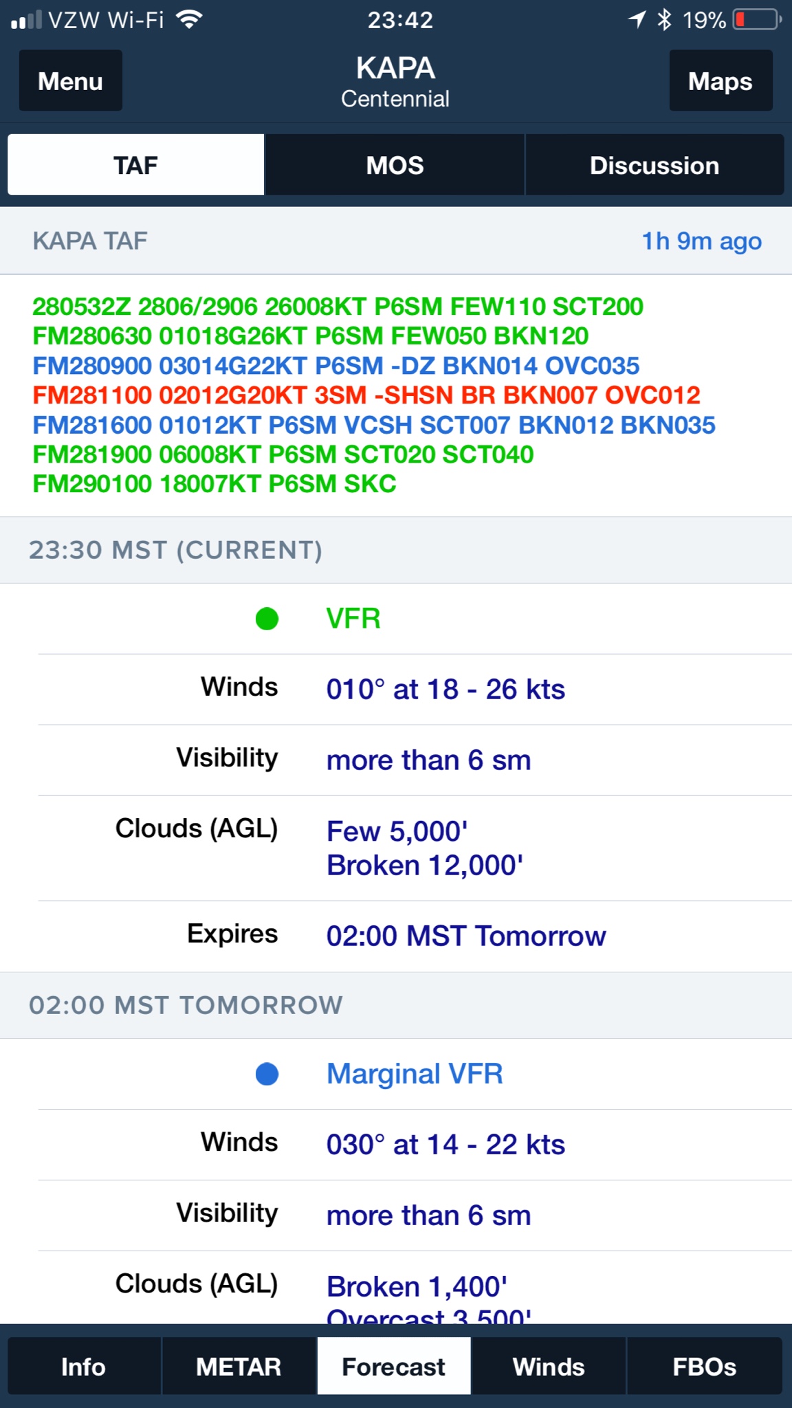
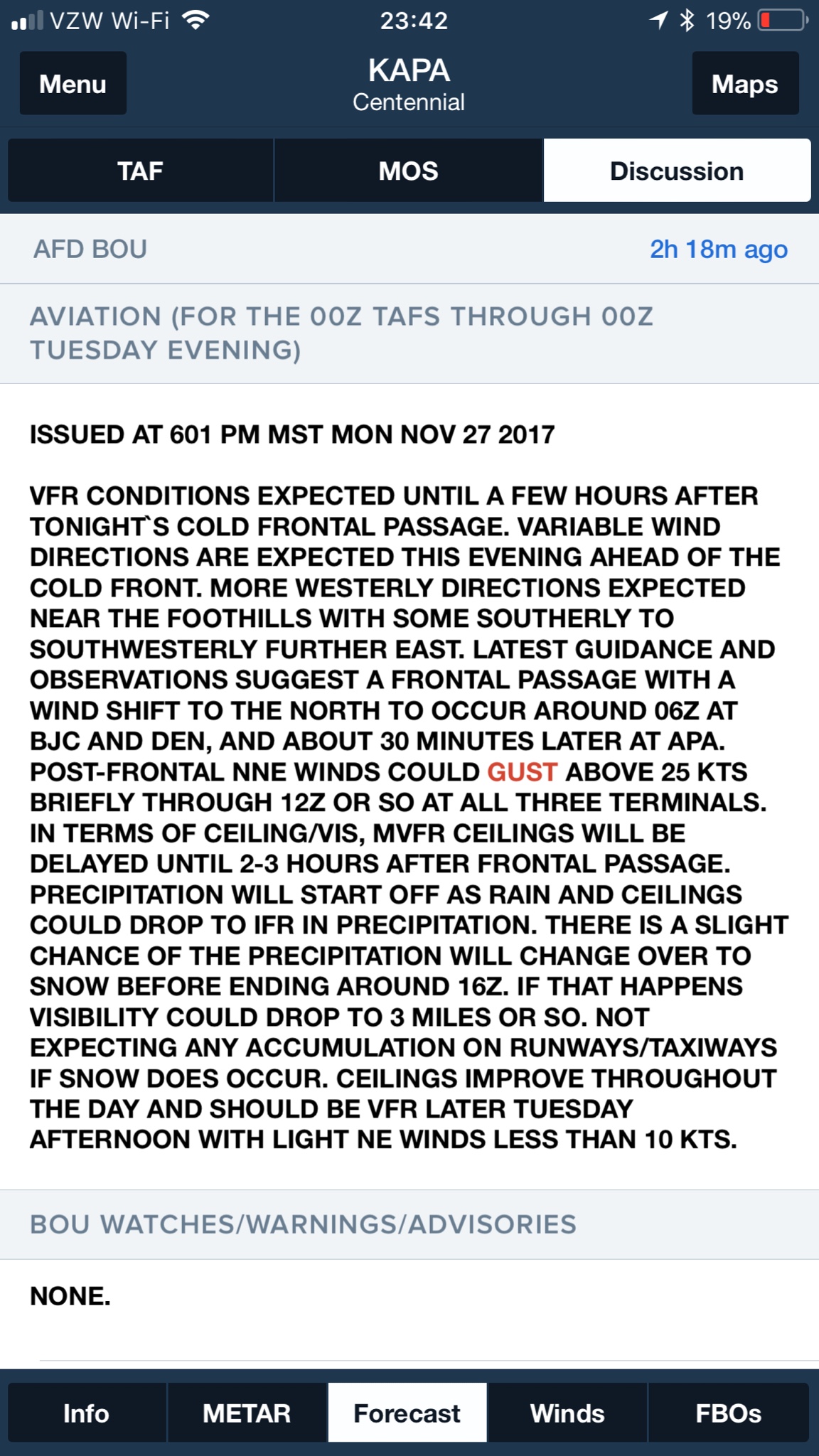
I had some time before my preflight so I got the phone with the briefer. We have been venturing to other fields so I had the briefer consider a 30 mile radius around the field. A few low altitude icing pireps about 50 miles north, and general mountain obscuration sigmets in various areas. There was a note for high winds with 25 mph gusts, but later in the day, closer to noon. I think this is the key part my rookie brain failed to decode, but the briefer didn't raise any alarm bells for my stated 1 hour of flight time from 9:30 AM EST.

So my question is - how could I have predicted the high winds at that precise time? What didn't I see. If we had taken off 15 minutes earlier we would have struggled to get it back on ground and with the ceilings dropping we could not have gotten out of the valley. Scary stuff.
 
Last edited:
Look at the TAFs. If your airport doesnt have them, look at the closest airport that does. Call Flight Service.
 
See that jump from 9:15 AM to 9:45 AM on the Wind Speed graph. This is what I'm talking about. Looking for historical TAF data, onesec.

histGraphAll
 
Depending on where you are, you may be able to see a steep pressure gradient (isobars with tight spacing) on a map that would denote higher winds eventually coming your way. What little experience I have with aviation weather is that timing is a big "if"...you may have been able to see this coming but even if you did, the timing may have been uncertain. Maybe look at METARS for airports around you as well to see what's headed your way or about to go away. Don't mess around with timing.
 
This is the data from the day.

METAR/SPECI from KAVP, Wilkes-Barre - Scranton, Wilkes-Barre / Scranton International Airport (United States).
SA 22/11/2017 17:54->
METAR KAVP 221754Z 34013G18KT 10SM OVC029 04/M02 A3000 RMK
AO2 SLP162 60001 T00441017 10056 20028 51010=

SP 22/11/2017 17:47->
SPECI KAVP 221747Z 34010KT 10SM OVC029 04/M02 A3000 RMK AO2
T00441017=

SP 22/11/2017 17:27->
SPECI KAVP 221727Z 35014KT 10SM SCT025 BKN030 OVC046 04/M02
A2999 RMK AO2 T00441017=

SA 22/11/2017 16:54->
METAR KAVP 221654Z 34014G22KT 10SM OVC022 04/M01 A2999 RMK
AO2 PK WND 33026/1604 SLP159 T00391006=

SA 22/11/2017 15:54->
METAR KAVP 221554Z 34016G21KT 10SM BKN017 OVC024 04/01 A3000
RMK AO2 SLP161 T00440006=

SP 22/11/2017 15:35->
SPECI KAVP 221535Z 35016G20KT 10SM BKN016 OVC020 04/02 A2999
RMK AO2 T00440017=

SP 22/11/2017 15:21->
SPECI KAVP 221521Z 35013G20KT 10SM BKN014 BKN020 OVC027 05/02
A2998 RMK AO2 T00500022=

SA 22/11/2017 14:54->
METAR KAVP 221454Z 34013G23KT 10SM OVC016 06/03 A2997 RMK
AO2 RAE1357 SLP152 P0000 60001 T00560028 53015=

SP 22/11/2017 14:10->
SPECI KAVP 221410Z 00000KT 6SM BR BKN025 BKN030 OVC046 04/03
A2995 RMK AO2 RAE1357 P0000 T00390028=

SA 22/11/2017 13:54->
METAR KAVP 221354Z 25003KT 8SM -RA FEW027 BKN046 OVC110 05/03
A2993 RMK AO2 RAB07 SLP139 P0001 T00500033=

SA 22/11/2017 12:54->
METAR KAVP 221254Z 00000KT 8SM SCT055 OVC075 03/02 A2993
RMK AO2 RAB02E46 SLP138 P0000 T00330022=

SA 22/11/2017 11:54->
METAR KAVP 221154Z 15003KT 10SM FEW049 OVC060 04/02 A2992
RMK AO2 SLP136 T00390022 10089 20033 53009=

SA 22/11/2017 10:54->
METAR KAVP 221054Z 21003KT 10SM SCT060 BKN075 OVC110 04/02
A2990 RMK AO2 PRESRR SLP129 T00390022=

SA 22/11/2017 09:54->
METAR KAVP 220954Z 10004KT 10SM BKN080 OVC100 04/03 A2988
RMK AO2 SLP119 T00440028=

SA 22/11/2017 08:54->
METAR KAVP 220854Z 00000KT 10SM FEW095 06/03 A2990 RMK AO2
SLP125 T00560033 58009=

SA 22/11/2017 07:54->
METAR KAVP 220754Z 00000KT 10SM SCT085 07/03 A2992 RMK AO2
SLP132 T00720033=

SA 22/11/2017 06:54->
METAR KAVP 220654Z 00000KT 10SM BKN080 08/03 A2993 RMK AO2
SLP133 T00830033=

SA 22/11/2017 05:54->
METAR KAVP 220554Z 00000KT 10SM FEW075 08/03 A2993 RMK AO2
SLP133 T00780028 10089 20050 58018=


No short TAF reports from KAVP during solicited interval in the database.


large TAF from KAVP, Wilkes-Barre - Scranton, Wilkes-Barre / Scranton International Airport (United States).
FT 22/11/2017 17:35->
KAVP 221735Z 2218/2318 33011G21KT P6SM BKN050 FM222200 33011KT
P6SM SCT090 FM230500 32007KT P6SM SCT250 FM231700 28005KT
P6SM SCT250=

FT 22/11/2017 11:41->
TAF KAVP 221141Z 2212/2312 26005KT P6SM -SHRA OVC050
TEMPO 2213/2215 31008G15KT 4SM -RA OVC020 FM221500 33010G17KT
P6SM BKN030 FM221800 33012G20KT P6SM BKN050 FM230100
33007KT P6SM FEW200=

FT 22/11/2017 09:04->
KAVP 220904Z 2209/2306 VRB04KT P6SM SCT070 BKN100 FM221500 33008G16KT
P6SM BKN020 FM221800 33012G22KT P6SM SCT035 FM222300
33007KT P6SM FEW050=

FT 22/11/2017 05:42->
TAF KAVP 220542Z 2206/2306 VRB04KT P6SM SCT070 BKN100 FM221500
33008G16KT P6SM BKN020 FM221800 33012G22KT P6SM SCT035
FM222300 33007KT P6SM FEW050=
 
So that TEMPO issued at 11:41 UTC (6:41 AM EST) for 2213/2215 (8 AM to 10 AM) with 31008G15KT 4SM should have been a big clue I take it?
 
So that TEMPO issued at 11:41 UTC (6:41 AM EST) for 2213/2215 (8 AM to 10 AM) with 31008G15KT 4SM should have been a big clue I take it?

I didn’t look at the rest of the historical full weather picture for your area, but yes. TEMPOs are often associated with a frontal passage or similar, creating a rapid change and then things calming down again.

Not listed as TEMPOs because it’ll take hours, but we have a frontal passage starting now overnight into late morning. The big change here is going to be ceilings and temperature, along with snow as some precipitation... but it would look similar for a big dry system with a wind change...

b7fc52a0c391459af6b87549233df9a8.jpg


Also don’t forget to read the weather discussion for the area(s) from NWS... that can give big hints as to both what might happen and whether the forecaster feels confident in their predictions or why not...

243ff2ce0dfc2ba3996ddb89852ec271.jpg
 
Also don’t forget to read the weather discussion for the area(s) from NWS... that can give big hints as to both what might happen and whether the forecaster feels confident in their predictions or why not...

The WX discussions are awesome. Some regions are better than others with the amount of detail they stick in there. You can get a feel for certainty of the forecast; They can throw their thoughts around in this section unlike anywhere else in the forecast. This is a major part of my initial preflight planning.
 
The WX discussions are awesome. Some regions are better than others with the amount of detail they stick in there. You can get a feel for certainty of the forecast; They can throw their thoughts around in this section unlike anywhere else in the forecast. This is a major initial part of my initial preflight planning.

Yeah they’re quite variable depending on the culture of the particular forecast office and the personalities of the forecasters themselves. We have some characters around here.

I also must admit, our NWS office is on a losing streak for accuracy and is well behind the folks over at Accuweather. I suspect there’s an old timer over there that knows the quirks of this area better for some reason.

Something like that can change from year to year as forecasters come and go eventually. Right now, AW is on top around here. Not by huge margins, but where it counts in precip and wind.

Sometimes when AW has beat NWS the discussion will have had someone whining about “the models not agreeing”. I think sometimes NWS Boulder gets a little too eggheaded and tech centric and doesn’t just look out the window. Ha.
 
Winds looked marginal for the xwind component of the 172...
Keep in mind that 15 knots is the demonstrated max, not the absolute max the plane can handle. Do what ever your comfortable with but don't want you thinking if there's a 16 knot cross wind that you're not going to have enough rudder authority to get it down.
 
So that TEMPO issued at 11:41 UTC (6:41 AM EST) for 2213/2215 (8 AM to 10 AM) with 31008G15KT 4SM should have been a big clue I take it?
Yea, seems like the TAF was telling you all along that winds were picking up at 1500 zulu and getting stronger thereafter. And you were planning to leave at 14:30 returning at 15:30. They didn't really modify the TAF that much over the last 3 intervals:

upload_2017-11-28_9-21-3.png

I guess you got lucky they picked up a bit early.(if you weren't wanting to push your crosswind limits)
 
Not sure if this will help you @Jon Belanger but here goes.

For my entire PPL training (not done yet) I first look at the weather from NOAA.GOV. Enter your location (or closest location), forget the pictures and summaries and go directly to the hourly forecast. For XC's I opened 3 or 4 different locations in separate browsers and line them up on the same start time. So far, this has worked extremely well for me. Out of 50 flights there have been a few times where I avoided scheduling on a day I thought would have nasty winds and it wasn't so bad. Otherwise it has been really, really good especially within 3 days or less. And I have used it to purposely pick crosswind days with the instructor.

For scuba diving in Mexico where Norte's can come in and close the ports for diving, I always use Wind Guru. I look 3-4 days out, then book dives or take a break on the NNW high wind days. So, back to flying. Once in a while I will also dial in Wind Guru and take a peak at the various models, check gusts, etc. Since there are several models here, you can often find one that might make you sit out a flight. But use the information to compare, correlate, etc.

And my newbie observation. Man, now that its winter it seems like the winds aloft are like 4-5x the surface winds at just 500agl. And it seems like the morning winds come up really fast.
 
Just my opinion. I would use those windy conditions to go up and practice with your instructor. I wouldn't consider those winds to be no go by any means (not sure what runway you guys were using?). I understand your hesitation of soloing in those winds, I wouldn't have soloed in those winds either.

I used to not fly if winds were over 10 knots, which looking back was really silly. At some point you are going to find yourself landing in windy/gusty conditions and you'll have to deal with it even if it doesn't feel completely comfortable to you. So use these times to go up with your instructor, it can really boost your confidence for those times when you have to deal with these things solo.

I agree, but I wasn't PIC,and given the long term outlook I think it was the right decision. 5/6 kts crosswind isn't an issue, but I would rather be comfortable in >10.
 
So thinking back on this incident, I think I heard the briefer say the expected winds on the TAF - he must have read that to me - but given the time range (8 AM - 10AM). I assumed they would start when we were already 30 minutes into our flight and we would have to time to get it down. Also in my head I heard I interpreted it as "closer to noon" since they were gusting to 20 kts at 1300Z, which is 100% wrong. The suddenness of the pick up in the winds is the unknown by just reading the TAF. Reading through the lines of these replies, I really just need to check all available data. Pay attention to start times, and if it's close afa timing, look at the local fields to get a picture of what's going on and definitely always look at the available maps. Lesson learned.
 
Last edited:
And honestly that OVC020 is barely VFR in the pattern for a 500 foot field. We would be right at 500' below is class E. I feel like the briefer should have highlighted this, or is that not their job?
 
The cloud heights are AGL, so your field elevation doesn't matter.

But pattern altitude is 1500 (actually more like 1560), so we would be just under 500 feet from the bottom of the OVC clouds right?
 
But pattern altitude is 1500 (actually more like 1560), so we would be just under 500 feet from the bottom of the OVC clouds right?

What is your home field? I assume field elevation is ~560? If so that means OVC would be 2560. You would have 1000' clearance.
 
So my question is - how could I have predicted the high winds at that precise time? What didn't I see. If we had taken off 15 minutes earlier we would have struggled to get it back on ground and with the ceilings dropping we could not have gotten out of the valley. Scary stuff.

You can't reliably. After solo, your CFI will hopefully introduce you to pretty large crosswinds. Lots of times I've had "winds calm" forecast turn into some real blasters (30G35).

Keep in mind that 15 knots is the demonstrated max, not the absolute max the plane can handle. Do what ever your comfortable with but don't want you thinking if there's a 16 knot cross wind that you're not going to have enough rudder authority to get it down.

He's pre-solo ...

Just my opinion. I would use those windy conditions to go up and practice with your instructor. I wouldn't consider those winds to be no go by any means (not sure what runway you guys were using?). I understand your hesitation of soloing in those winds, I wouldn't have soloed in those winds either.

If he's consistent, this practice is a good idea. If he's only at 10-14 hours, maybe not so good an idea yet.

In my area, especially spring, it can blow and not be forecast. CFI used a 3 gear type system:

1. Solo in < 10 knot crosswind
2. Practice in above that
3. Wanted to see landings with him on board that were in the 20-24 range prior to end of training.
 
The weather you are showing is KAVP where the elevation is 962ft. If the cloud base is reported as 020 that means that the clouds are at 2000' + 962' = 2962ft MSL altitude. Not sure which airport you are flying at, but your cloud clearance for at 1500' pattern altitude is then 2962' - 1500' = 1400+ ft. Assuming the clouds are not forecast to get lower, that's plenty for pattern work.
 
The weather you are showing is KAVP where the elevation is 962ft. If the cloud base is reported as 020 that means that the clouds are at 2000' + 962' = 2962ft MSL altitude. Not sure which airport you are flying at, but your cloud clearance for at 1500' pattern altitude is then 2962' - 1500' = 1400+ ft. Assuming the clouds are not forecast to get lower, that's plenty for pattern work.

Yes, thanks for the clarification. Hopefully this doesn't slip my mind again. Your numbers also track what we saw visually. Though I did note that there was some cloud bases East of KAVP that had descended below the tallest mountain there (the one on the sectional with the windmills), and we don't have 3000' mountains here.
 
TEMPO groups are used by forecasters to indicate truly "temporary" conditions. That is, the conditions they forecast can only last for at most 1/2 of the length of the TEMPO period, can only occur for less than one hour in each instance and they are expected to have a 50% or greater chance of occurring. Otherwise, a From (FM) group will be used. Moreover, TEMPO groups can be used to indicate conditions that are expected to temporarily improve (they are not always about bad stuff).

Also a TAF is only valid 5SM from the center of the airport's runway complex. So, if your airport doesn't have a TAF, please don't use the closest TAF; doing so is using the forecast beyond it's designed limits. You should only use a TAF if you are actually planning to depart from or fly to that airport. That doesn't mean you should ignore the TAFs along your route. They provide excellent guidance if you must terminate your flight early or fly to it as an alternate.

Home airport is just outside the class D circle on the sectional - KWBW. We have to be careful to not fly into their airspace prior to turning cross for 7 or 9. I'm sure someone mentioned the 5 SM rule in ground training but in one ear and out the other. What would you recommend then? Thank you.
 
Last edited:
He's pre-solo ...

Hence the 'Do what ever your comfortable' part. It took me well into 100 hours to be moderately comfortable with Xwind landings. Luckily in Oklahoma I was getting a lot of practice... my worst landing ever was with an 8 knot direct.
 
For airports without a TAF, I like to use the GFS Model Output Statistics (MOS). It uses the forecast from the GFS model and combines that with geoclimatic data specific to the airport. Forecasters use MOS to help them construct the TAF. In most cases it'll give you some

Thanks for the example and the suggestion, good stuff. This is better than ground school!
 
I use a combination of sites and apps as well.
I had to drive quite a ways for training, so I always wanted to know if it was a go or no go before driving.

WEBSITES: (not all corrected for your area)
https://www.aviationweather.gov/progchart/sfc - choose different time frames from the menu and look at isobars as mentioned
https://www.wunderground.com/forecast/us/pa/kwbw/18705?cm_ven=localwx_10day
https://www.accuweather.com/en/us/w...ort-pa/18644/hourly-weather-forecast/7894_poi
www.usairnet.com add your location


APPS:
Windalert app on phone (my favorite and the most accurate I've seen for 5-6 days out)
Windfinder - shows longer out forecast, but not quite as accurate
 
On the really windy hard to land days, you could re-arrange your name a little...and I could use it.

Jon LeBanger :cheerswine:
 
Last edited:
I like windy.com as some others mentioned, if it hurts your computer you can turn off the animations. If I'm really looking for absurd levels of detail I like staring at things like https://rucsoundings.noaa.gov (and others doing forecast models showing Skew-T ) But being that I'm instrument rated I'm most often looking for freezing levels and cloud heights to see if I can go over any of the mountains here in the west.
 
Ever notice that the wind is usually a lot calmer at night? Sometimes no wind at all after a windy day? That's nocturnal inversion. The sun goes down, the ground cools off, it stops heating the air above it, thermal activity ceases, and that cooling air gets heavier and tends to "disconnect" (for want of a better term) from the upper air. It stops moving.

In the morning, look at the upper winds forecast. If it shows lots of wind a thousand or two thousand feet up, expect the wind on the ground to pick up once the sun comes up and starts heating the ground, which will heat the air above it. You can often go flying early in the morning, with no wind on the ground, and encounter a layer of turbulence during the climb. Fly around awhile, and come back to the circuit and find that layer of turbulence (and wind shear with it) much lower than it was when you left. After you land and put the airplane away, the windsock might come alive. Seen it dozens of times. Very common on flatter terrain. You pay attention to the upper winds and see; you will soon recognize a pattern and be able to predict the wind.
 
I think we also take for granted that back in the day, the weather online or on TV always showed the frontal diagram. Nowadays they want it to feel more like magic that they got the forecast right, and they rarely show that map.

I’d rather look at one of those than the stupid graphics they have on TV weather these days. After you look at them for years and years you see patterns before the “weather personality” even starts talking.
 
Ever notice that the wind is usually a lot calmer at night? Sometimes no wind at all after a windy day? That's nocturnal inversion. The sun goes down, the ground cools off, it stops heating the air above it, thermal activity ceases, and that cooling air gets heavier and tends to "disconnect" (for want of a better term) from the upper air. It stops moving.

In the morning, look at the upper winds forecast. If it shows lots of wind a thousand or two thousand feet up, expect the wind on the ground to pick up once the sun comes up and starts heating the ground, which will heat the air above it. You can often go flying early in the morning, with no wind on the ground, and encounter a layer of turbulence during the climb. Fly around awhile, and come back to the circuit and find that layer of turbulence (and wind shear with it) much lower than it was when you left. After you land and put the airplane away, the windsock might come alive. Seen it dozens of times. Very common on flatter terrain. You pay attention to the upper winds and see; you will soon recognize a pattern and be able to predict the wind.

In general it's calmer at night, maybe, but that isn't a hard and fast rule. It was pretty windy here last night around midnight. Very calm this morning though, which is typical. This isn't flatter terrain here in the Northeast and I found it's difficult to notice patterns aside from "it's gets colder in the winter".
 
Back
Top