Holy Crap, my house is in ForeFlight

flyingron

Administrator
Management Council Member
Joined
Jul 31, 2007
Messages
24,219
Location
Catawba, NC
Display Name

Display name:
FlyingRon
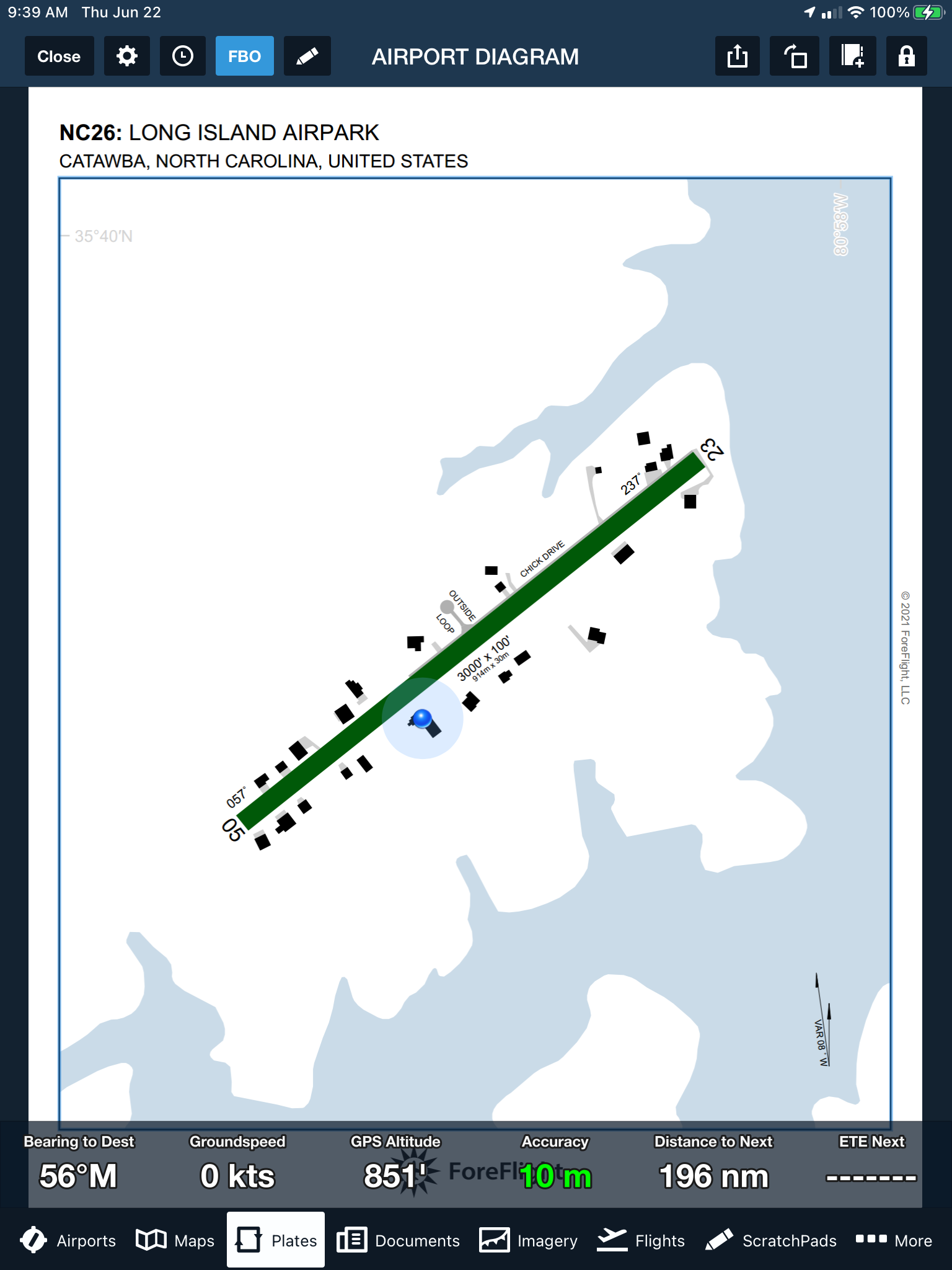
I'm sitting in my house with my iPad on the desk (I was downloading current charts). Now I've previously had it warn me that I was about to enter Runway 5/23 (I guess the GPS uncertainly thought I was moving toward the runway which is about 75 feet away). But today, it suddenly popped up a chart and showed the blue dot right on my house (the black L-shaped building shown).

52992701337_f61e202c4d_o.png
"
 
All smart ass remarks aside, this is new for ForeFlight to pop up geo referenced airport diagrams for smaller airports. My house is also showing up now, and we’re tiny. I don’t think any of the other apps are doing that yet.
 
I love that show.

All smart *** remarks aside, this is new for ForeFlight to pop up geo referenced airport diagrams for smaller airports. My house is also showing up now, and we’re tiny. I don’t think any of the other apps are doing that yet.

It's sad when someone thinks we need georeferenced charts for a single runway no taxiway airport.
 
Huh. I just tried it. It reports the location as my house, but I'm sitting in the pub.
 
I love that show.


It's sad when someone thinks we need georeferenced charts for a single runway no taxiway airport.
Yeah, who wants people that have never been somewhere to have a way to navigate? They should suffer lie everyone else did learning where the dead ends are what roads go through.

many people that come here taxi back on the runway not realizing there are taxiways. With the diagram they can see there is an option to free up the runway. And it’s absolutely not obvious without the diagram.

So the taxiway is covered with trees or structures and can't be seen from the air. *Affirming head nod*
 
Our taxiway is not shown. There should be one just east of my house (distinct from the roadways that also double as taxiways for those who don't have runway frontage).
 
Our taxiway is not shown. There should be one just east of my house (distinct from the roadways that also double as taxiways for those who don't have runway frontage).
Interesting. Our taxiways, some of which are also roadways, are shown with crazy detail, even the small turnarounds show up. And all but the last house built recently is on the map, including the ponds and such. Notably missing is the fuel pump. The pad it's on is shown, but no indication that it's fuel.
 
Huh. I just tried it. It reports the location as my house, but I'm sitting in the pub.

You have the pro version that covers for you?

What happens if you fly under a bridge?
 
Any intel on how ForeFlight populates these unofficial taxiway diagrams? Are they periodically autogenerated? I'm curious how they'd account for changes, such as if Ron tore his house down.. would it eventually disappear from the chart?
 
How did the runway get the name "Chick Drive"?

That's not the runway, but Chick Drive runs along the side of part of the runway (those houses taxi across the road to get to the runway). Chick is Chick Saunders one of the original owners of the airport. The airport was originally developed by H.K. Zeke Saunders who flew "The Hump" in WWII and was the first (and ultimately chief) pilot for Piedmont Airlines. The airport is located on "Saunders Road." There's a set of lots just off the airport where many of teh Saunders kin had trailers called "Saunderosa."

The airport was later expanded and developed into a residential airpark by a couple of airline pilots. The streets they added have names like Outside Loop, Clipper Court, Aeromarine Boulevard, and Catalina Boulevard.
 
Any intel on how ForeFlight populates these unofficial taxiway diagrams? Are they periodically autogenerated? I'm curious how they'd account for changes, such as if Ron tore his house down.. would it eventually disappear from the chart?
I'm assuming they used the Digital Globe data either directly or through Google.
 
Any intel on how ForeFlight populates these unofficial taxiway diagrams? Are they periodically autogenerated? I'm curious how they'd account for changes, such as if Ron tore his house down.. would it eventually disappear from the chart?

I'm assuming they used the Digital Globe data either directly or through Google.

I don't know all the open sources of geographic data that ForeFlight could be using, but at least some of them are outright dumb. Some maps show buildings in the places where farmers have conexes parked for storage or even a broken-down hay baler parked. And some of the dumber truck drivers here follow a magenta line to get to a sand pit near my house, by way of a half mile of a public "no trucks" road (in fairness, the "no trucks" sign was missing for a few years until it was replaced this summer, having been destroyed by a wayward truck whose driver couldn't read or negotiate a stop sign-controlled intersection), my private road with 7 "no trespassing, residents only" signs on it, my 5 tree rows, and a half mile of rough, open country plus two fence crossings and a drop-off into the back side of the sand pit itself.
 
How else am I going to roll my own approach?
I've never done it (if it is not VFR here I land just north at SVH and wait it out or have someone come get me).
However, some have noted that if you fly the RNAV 14 approach into 14A, you fly essentially a base leg for our 23. If you dive down at OKECU quickly you can hope to break out at 600AGL and turn right and land on 23.
 
The "3D" stuff in Google is mostly due to LIDAR passes. We used to write software back a decade or so ago that through out the trees from LIDAR and found the structures. It's likely some variation on that idea. Though there's no 3D stuff in googlemaps on my house.
 
Last edited:
Not my house, but somewhat related. My airplane is (currently) showing up in the Apple maps sat view of the airport on Catalina Island (KAVX). It's the blue and yellow plane in the center of the pic. Must have been taken a couple of years ago when we flew down for lunch and a hike. Someday, when they refresh the overhead pictures, it'll disappear, but for now, it's kinda neat.


0e4d6337251aff4e00653e7032ed4779.jpg


Sent from my iPhone using Tapatalk Pro
 
Google Street view isn't working - I'm standing on the front porch of my house right now and it is not showing me in the picture.

How is that possible?


:)
 
Any intel on how ForeFlight populates these unofficial taxiway diagrams? Are they periodically autogenerated? I'm curious how they'd account for changes, such as if Ron tore his house down.. would it eventually disappear from the chart?

I would guess that it wouldn’t be too difficult to have a machine learning computer vision algorithm generate the basic map with water shown and houses from satellite data. Merging that with the FAA data might be a bit tougher though.
 
Since you're more or less on the runway, can you log time by just making a noise like an airplane, if you're thinking about flying? Do you have to pay a landing fee if you walk into the kitchen? If there should be a TFR over your airport, are you allowed to go outside? Things I'd wonder about if I lived on an airport.
 
Since you're more or less on the runway, can you log time by just making a noise like an airplane, if you're thinking about flying? Do you have to pay a landing fee if you walk into the kitchen? If there should be a TFR over your airport, are you allowed to go outside? Things I'd wonder about if I lived on an airport.
I’ve not thought about that for a minute. I have had a neighbor wave me down and call me when I was taxiing to calibrate a magnetometer while there was a TFR active above us. “Above us” is the key. I felt bad that I’d caused him to freak out so much, but it’s another nice benefit of living on the airport. Everybody generally looks out for each other.
 
Since you're more or less on the runway, can you log time by just making a noise like an airplane, if you're thinking about flying? Do you have to pay a landing fee if you walk into the kitchen? If there should be a TFR over your airport, are you allowed to go outside? Things I'd wonder about if I lived on an airport.

I don't make airplane noises, but my parrot (who likes to fly in the right seat) does. She's particularly fond of my neighbor's Seabee. If she even sees it parked she starts making engine noises.
 
Okay Flyingron, now that we all know where you're "cribbing", when is the fly-in Barb-ba-Que... I got some great Wagu Tri-Tip I can bring
 
Back
Top