Reviving this for a couple of ?s
One doesn’t need a clearance, correct? Just stay above the minimum sector altitude and in the corridors, fly the appropriate NB or SB altitude?
Outside the corridors- one can fly freely above the minimum sector altitude, is that right? Outside the corridors- say in between s terminus of Tuckup corridor- east of VPGCA- one could circle at 11,000 ft as one isn’t in a corridor, and is above the minimum sector altitude?
If one used supplemental o2, you could overfly the toroweap Flight free zone at 15,500?
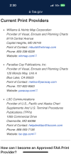
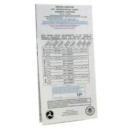
Lastly, how does one get a paper copy of the Grand Canyon chart?
fAA has outsourced to private printers, correct? I checked the websites of all three of the “current print providers”- no joy.
View attachment 126303View attachment 126303


")