
You are using an out of date browser. It may not display this or other websites correctly.
You should upgrade or use an alternative browser.
You should upgrade or use an alternative browser.
GPS175 Flight Plan Waypoint Question
- Thread starter farmrjohn
- Start date
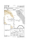
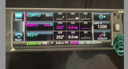

Maybe because there's something over 600 ft in front of you, so you should be at 922 ft altitude, just in case you don't make the turn?
I dunno, I'm not an IFR pilot.
I dunno, I'm not an IFR pilot.

- Joined
- May 25, 2006
- Messages
- 21,997
- Location
- KTTA, North Carolina
- Display Name
- Who you kiddin?
- Home Airfield
- KTTA
It’s the standard 400 AGL before making any turns for standard obstacle separation.

bentmettle
Pre-takeoff checklist
flip back to the procedure page and preview it from there -
It was an interesting question so I am looking at it on my ipad- does the 175 not let you set altitudes in the flight plan? I'm not seeing how to do it just monkey button pushing...
It was an interesting question so I am looking at it on my ipad- does the 175 not let you set altitudes in the flight plan? I'm not seeing how to do it just monkey button pushing...

DGlaeser
Pre-takeoff checklist
- Joined
- Oct 16, 2008
- Messages
- 268
- Location
- Rochester Hills, MI
- Display Name
- DGlaeser
- Home Airfield
- 57D and VLL
Very strange... I've only seen that when the missed approach specifies an altitude on climb out before any turns. Minimums are well above 922 ft, so you should only be that low if descending to land. I don't see that in the departure procedures.
That entry in the procedure is in the Garmin Trainer S/W and the date on the databases is Nov 2023, so it is nothing new...
The 175/355/375 do not let you set altitudes in the flight plan.
A good question for Garmin!
That entry in the procedure is in the Garmin Trainer S/W and the date on the databases is Nov 2023, so it is nothing new...
The 175/355/375 do not let you set altitudes in the flight plan.
A good question for Garmin!
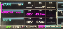
I notice the distance is 0.0NM but for the RNAV (GPS) RWY 28R at KMYY it has a distance to that altitude from the MAP and the altitude corresponds with the DA for the LPV approach. That one I can understand.
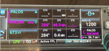
For the original question then, is it the altitude before starting a turn if you have started down from the MDA, or the altitude you "should" be if you started a stabilized descent from the VDP when reaching the MAP ASIYO. That is close to the 300' per mile gouge.It’s the standard 400 AGL before making any turns for standard obstacle separation.
- Joined
- May 25, 2006
- Messages
- 21,997
- Location
- KTTA, North Carolina
- Display Name
- Who you kiddin?
- Home Airfield
- KTTA
Nothing that esoteric. It’s just the standard 400’ above DER before making turns that guarantees obstacle clearance on IFR departures unless a greater climb gradient is specified. Look at the OP chart.For the original question then, is it the altitude before starting a turn if you have started down from the MDA, or the altitude you "should" be if you started a stabilized descent from the VDP when reaching the MAP ASIYO. That is close to the 300' per mile gouge.
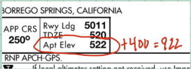
I don’t recall when the feature first showed up and I’m not sure it appears in all navigators, but if it does it will be there on all missed approaches with a turn if there is no procedure-directed climb.
Although I think the answer is staring at us on the chart, since you insist...A good question for Garmin!
Why There is an Altitude only Waypoint for the Missed Approach Sequence in the Flight Plan.
Last edited:
- Joined
- May 25, 2006
- Messages
- 21,997
- Location
- KTTA, North Carolina
- Display Name
- Who you kiddin?
- Home Airfield
- KTTA
If you insist.A good question for Garmin!
Why There is an Altitude only Waypoint for the Missed Approach Sequence in the Flight Plan.
- Joined
- May 25, 2006
- Messages
- 21,997
- Location
- KTTA, North Carolina
- Display Name
- Who you kiddin?
- Home Airfield
- KTTA
No, the Garmin "Navigator" series (GPS, GNC, GNX) don't allow for pilot-created altitude restraints.flip back to the procedure page and preview it from there -
It was an interesting question so I am looking at it on my ipad- does the 175 not let you set altitudes in the flight plan? I'm not seeing how to do it just monkey button pushing...
DGlaeser
Pre-takeoff checklist
- Joined
- Oct 16, 2008
- Messages
- 268
- Location
- Rochester Hills, MI
- Display Name
- DGlaeser
- Home Airfield
- 57D and VLL
Thanks for the link. I don’t see a date on that article, when did that start?
- Joined
- May 25, 2006
- Messages
- 21,997
- Location
- KTTA, North Carolina
- Display Name
- Who you kiddin?
- Home Airfield
- KTTA
No idea. Just before I posted it is the first time I looked for a reference. I didn't really notice or even think about it until I saw a similar question from a pilot. Maybe a year or so ago ,gove or take a few months. I looked at the airport elevation and the GPS snapshot and thought, "oh, that's what it is."Thanks for the link. I don’t see a date on that article, when did that start?
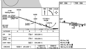
Thanks for the link and explanation. Looking at some other approaches I'll consider that the minimum turn altitude, useful for initiating a missed after starting descent from minimums or as required on the missed approach procedure as in the RNAV (GPS) RWY 8L at KSDM.
MauleSkinner
Touchdown! Greaser!
Just understand that the published procedure still may not protect you if you go missed after leaving minimums.Looking at some other approaches I'll consider that the minimum turn altitude, useful for initiating a missed after starting descent from minimums
- Joined
- May 25, 2006
- Messages
- 21,997
- Location
- KTTA, North Carolina
- Display Name
- Who you kiddin?
- Home Airfield
- KTTA
Right. In this one at SDM, it's a published altitude and while there's not a big difference, it's higher that the standard 400. And .. this may be the reason Garmin decided to add it .. did you already know in the L08 one that you should be above 400 over DER before making that turn?Thanks for the link and explanation. Looking at some other approaches I'll consider that the minimum turn altitude, useful for initiating a missed after starting descent from minimums or as required on the missed approach procedure as in the RNAV (GPS) RWY 8L at KSDM.
Last edited:
Yes for a departure. I was not considering a "departure" as part of a missed approach, hence my confusion. At L08 the DER is almost two miles from the MAP, where the turn would ordinarily be initiated if going missed on the approach. On this approach if you didn't see the runway at minimums until the MAP it would be an unstabilized descent to landing, loosing 1200' in one mile and not prudent to start down. That 922' altitude on the flight plan page would be handy as a reminder in the case of the proverbial truck pulling onto the runway necessitating a go around after starting the final descent for landing.Right. In this one at SDM, it's a published altitude and while there's not a big difference, it's higher that the standard 400. And .. this may be the reason Garmin decided to add it .. did you already know in the L08 one that you should be above 400 over DER before making that turn?
- Joined
- May 25, 2006
- Messages
- 21,997
- Location
- KTTA, North Carolina
- Display Name
- Who you kiddin?
- Home Airfield
- KTTA
That's true, but that can also be true with any climb to altitude before turning.Yes for a departure. I was not considering a "departure" as part of a missed approach, hence my confusion. At L08 the DER is almost two miles from the MAP, where the turn would ordinarily be initiated if going missed on the approach. On this approach if you didn't see the runway at minimums until the MAP it would be an unstabilized descent to landing, loosing 1200' in one mile and not prudent to start down. That 922' altitude on the flight plan page would be handy as a reminder in the case of the proverbial truck pulling onto the runway necessitating a go around after starting the final descent for landing.
Steamflyer
Line Up and Wait
- Joined
- Mar 23, 2022
- Messages
- 954
- Display Name
- Steamflyer
Please review what a visual descent point is, what you can and cannot do there, and as @MauleSkinner so correctly noted, what is the cost/have lost if you continue past the VDP and then have to go missed. Particularly in a low performance aircraft. You will be making a climbing left hand turn in the soup for thousands of feet. So you don't hit the mountains.
The 922' MSL is about the altitude you would be at should you continue on a 3.46 degree glide path from the FAF having crossed the FAF at 2400 MSL. [Math suggests 2400- (4*5280*1.15*tan(3.46)) = 931' ] Of course, you'd have to break out at 1720 to be able to continue that GP; the VDP has other strictures that should be learned before using.
The 922' MSL is about the altitude you would be at should you continue on a 3.46 degree glide path from the FAF having crossed the FAF at 2400 MSL. [Math suggests 2400- (4*5280*1.15*tan(3.46)) = 931' ] Of course, you'd have to break out at 1720 to be able to continue that GP; the VDP has other strictures that should be learned before using.