Got this clearance today

Then there's something wrong in Foreflight. The 325 radial can't diverge from the airway. That is what defines it.
Rereading my post, I see why you jumped on this now. I meant the 325 bearing from ELB, not the radial. Yes, the radial defines the airway.

As for the 480, I'd be tempted to enter it as

DANA V363 JOGIT TUSTI V64...

You then just FLYLEG the TUSTI-COREL when it shows you close.
(If I was going to do it with the autopilot, I'd just hit HDG when close, do the FLYLEG, and tell the autopilot to intercept).
Yep, that works too, and avoids having to switch to the radios.
 
You can't build an unpublished hold on the G1000 (I wish). Maybe G2000.

I have tried that user waypoint thing, but it's just to much of a pain since you have to use LAT/LONG to define it. On the G1000 I just fly the first radial on Nav 1, have Nav 2 on the intersecting radial (TXK). Then switch from Nav1 to heading mode prior to the intercept, CDI to Nav2, then rearm the NAV function so it will intercept automatically and I don't have to sit there and watch it.

If you come up with a better way let me know.

I did what you did (fly actual VOR green needle indications).

However, the G1000 (newer firmware) will let you do a RAD/RAD waypoint type. BUT... (big caveat) I need to find a way to report to them how IMPOSSIBLE it is to use for actual use. See screenshots and commentary below, using my example (above) of the aforementioned TTT074 radial to intercept the TXK244 radial routing:

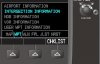
First of all, I love the new popup above the chapter that shows you the page selected with the small FMS knob. Helps you see which is next or previous in sequence... select Waypoints / User Waypoints.

attachment.php


For the record, I had NO flight plan and all user waypoints deleted when I started this with the new V12 Cessna Nav III sim (just received this week from Garmin, so it's the latest).

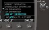
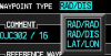
Name your waypoint. I marked it as temporary, but behavior shown below is the same either way. LEFT turn the small FMS knob when over WAYPOINT TYPE to select RAD/RAD (radial to radial) instead of the default RAD/DIS:

attachment.php


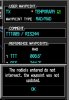
You'll notice the G1000 automatically put two VORs and their radials in the reference waypoints... ??? This causes a problem later. I wish it came up blank. Where did it pull these from? Remember, no flight plan, no user waypoints on file. Answer: Two nearest VORs, current position crossing radials. Confirmed by looking at the NRST / VOR page.

attachment.php


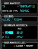
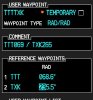
So, I start to override, and put in TTT 074 radial as the first reference radial for the waypoint:

attachment.php


When I hit enter to accept the radial, the G1000 complains that the 074 off TTT won't intercept the RIS 244.2 (my current position relative to the RIS VOR), and CHANGES MY TTT RADIAL to 008.6 to MAKE them match.

attachment.php


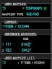
Now, if I go enter the TXK 244 radial, it again complains that the TXK 244 won't cross the TTT 008.6... and back and forth you go, between the two, narrowing the radial spread a degree or two at a time, TRYING to get them to match up. I finally gave up, unable to get it to accept both the TXK 244 and the TTT 074. I think the problem is these two radials are on a NEAR 180 degree intercept (170 degrees, actually).

attachment.php


AND, once I got the TTT radial to about 072 and the TXK to about 249 (working them towards each other), the G1000 suddenly changed the TTT value for me to 248 something, and put me over in North Richland Hills instead of north of Mount Pleasant airport, where I should have been with the TTT074/TXK244 combination. Then, changing TTT back to 070 wouldn't work, kept giving me the reciprocal radial. :mad2: :mad2: :mad2:

So, for now... fly the green needles, or plot the intersection on your chart and use Lat/Long or Radial/Distance waypoints.

Funny thing: you can press the RANGE knob and pan/zoom, but the radials for the two selected reference waypoints don't modify themselves to match your selected location. Instead, once you press ENTER during a pan/zoom user selection, it generates a Radial/Distance waypoint and cancels your RAD/RAD waypoint creation. :mad2: :mad2:

There's a menu option for 'use current location', but not a menu option to start with no reference waypoints and wait until you've entered BOTH values to perform a "do these two radials cross each other" check.
 

Attachments

  • ScreenShot172.jpg
    ScreenShot172.jpg
    18.6 KB · Views: 3
  • ScreenShot173.jpg
    ScreenShot173.jpg
    20.1 KB · Views: 168
  • ScreenShot174.jpg
    ScreenShot174.jpg
    24.2 KB · Views: 168
  • ScreenShot175.jpg
    ScreenShot175.jpg
    23.1 KB · Views: 167
  • ScreenShot176.jpg
    ScreenShot176.jpg
    30.4 KB · Views: 170
  • ScreenShot171.jpg
    ScreenShot171.jpg
    19.3 KB · Views: 164
  • ScreenShot162.png
    ScreenShot162.png
    39.9 KB · Views: 170
Last edited:
Rereading my post, I see why you jumped on this now. I meant the 325 bearing from ELB, not the radial. Yes, the radial defines the airway.


Exactly, nothing else matters to the Airway except the OBS/CDI indication. You have the proper radial dialed in and the needle with tested and verified equipment and you are on the radial regardless what the lady at NY TRACON is telling you...:rofl::rofl::rofl::rofl:
 
Exactly, nothing else matters to the Airman with his head up his @-- except the OBS/CDI indication. You have the proper radial dialed in and the needle with tested and verified equipment and you are on the radial regardless what the lady at NY TRACON is telling you...:rofl::rofl::rofl::rofl:
FTFY. :D
 
I did what you did (fly actual VOR green needle indications).

However, the G1000 (newer firmware) will let you do a RAD/RAD waypoint type. BUT... (big caveat) I need to find a way to report to them how IMPOSSIBLE it is to use for actual use. See screenshots and commentary below, using my example (above) of the aforementioned TTT074 radial to intercept the TXK244 radial routing:

Good write up. I have the latest version of the firmware on my bird. My G1000 sim is way out of date though. I'd like to try it in the actual aircraft to be sure. If you want to come to KADS and burn some gas to find out let me know.
 
Exactly, nothing else matters to the Airway except the OBS/CDI indication. You have the proper radial dialed in and the needle with tested and verified equipment and you are on the radial regardless what the lady at NY TRACON is telling you...:rofl::rofl::rofl::rofl:

Provided you have the RIGHT VOR dialed in. Mr. My Instruemnts are Fine appears to have dialed in ENO which was a few VORs down V16 than where he was (just SW of JFK).
 
Ah, something for me to try in the G1000 sim... haven't tried entering a manual hold, nor know if it's possible other than pressing SUSP and flying it manually. Of course, if it's the last fix on your Flight Plan, SUSP isn't going to do much! :)


Another thing for me to test on the sim; it's been a couple weeks on my to-do list after my IFR departure for Gastons, where I received this clearance route:

RV TTT074 TRISS TTT074 TXK244 TXK

As you describe below, I flew raw needles for the TTT074 - TXK244 route, as there's not a fix at those locations. I read the manual later and found that I can add a User Waypoint as the intersection of two radials, but I think you have to do that FIRST before you can use it in a Flight Plan route. I don't think there's a way to do it "on the fly" while entering a flight plan. Another thing for me to try today.


Are you with Chautauqua or American Eagle?

I think I just threw up a little in my mouth.

: )

Neither, I fly corporate. P180.
 
I think I just threw up a little in my mouth.

: )

Neither, I fly corporate. P180.

LOL. Excellent. Wasn't sure if you flew for one of the airlines, or Part 135 or corporate. Those are the only two airlines I know of with routes between those city pairs.
 
No it CAN NOT. The earth's curvature and variation does NOT have any effect on the airway. The airway is ALREADY defined as a VOR radial which is a straight line in space. The airway is the 325 RADIAL from ELB until you get to the changeover point (which is JOGIT in this case). It can't be anything else, this is how it is defined. A straight line form ELB to JOGIT is the 325 RADIAL

If your line on your echart or GPS diverges, that is a defect in your system.


You are confusing the heading to fly a course with the course definition itself.
Yes, the bearing (both to true and magnetic north) will change along the course, but the radial will remain the same.
VOR radials produce tracks over the ground that are great circle routes. A great circle route is defined as the intersection of the Earth's surface with a plane passing through the center of the Earth and that's exactly what you get with any course defined by the center of a transmitted electromagnetic signal (baring refraction by surface features). You don't normally see this on low altitude victor airways because the VORs are usually fairly close together and the chart's projection masks the effects (they'd be more apparent on a large globe).

But in any case you're correct that the VOR radial that defines the airway will not diverge from the airway as depicted on any chart unless one or the other is incorrectly drawn.
 
Last edited:
Exactly, nothing else matters to the Airway except the OBS/CDI indication. You have the proper radial dialed in and the needle with tested and verified equipment and you are on the radial regardless what the lady at NY TRACON is telling you...:rofl::rofl::rofl::rofl:
Couple of big IF's there, eh? Now just go away and leave me alone.:D
 
The way I would fly the OPs clearance on the G1000 would be to put DANAH as the first point in the flight plane, then load V363 with a point past the V64 intersection as the exit. I used JOGIT. Then I would zoom in the MFD, hit the range knob, move the cursor over to the airway intersection, hit enter, select create waypoint and name it T1. Then push the flight plan key, highlight JOGIT and enter T1. Then add the next waypoint on V64 which is COREL. Then menu, load airway, V64. Then I'd delete JOGIT and I'm on my way. A little quick and dirty but zoomed in on the MFD I bet my waypoint is within 200 feet of correct. As an added bonus, I'd put SLI in NAV1 just to make sure the bearing pointer was on the right radial when I turned.

I agree airway to airway routing is hard to program but I did the above in about two minutes on the sim.

I filed PDZ V21 HEC yesterday out of SNA and got the Anaheim 3 departure HEC transition with no amendments all the way home, a first for me.

You know I have thought about doing that, but I didn't because I'm always trying to get pinpoint accuracy. In this case that is kind of stupid, you're right I bet you could get within a couple hundred feet which is plenty accurate.

Of course it's implied, but you also have to change the map on the MFD to show airways unless you leave it that way (which most people don't).

Good one, thanks.

BTW- I am still curious to see if the new functions to define a waypoint would work (as described above). Did you try that?
 
Good write up. I have the latest version of the firmware on my bird. My G1000 sim is way out of date though. I'd like to try it in the actual aircraft to be sure. If you want to come to KADS and burn some gas to find out let me know.

I reported this to Garmin, and they agree it's not good how the RAD/RAD thing works today (see write-up with screenshots above), and they'll fix it:

Thank you for contacting Garmin,

I would be happy to assist you. There is a request to change this feature that is filed. This will be changed in a future software release. Currently the recommendation is to create a user waypoint from the map using cursor panning in the general area of where the radials intersect and then to edit the waypoint to refine the location to the correct position of the intersecting radials. Let me know if you need any additional information on how to accomplish this.

Best regards,
Todd C
Senior Aviation Field Support Specialist
Aviation Product Support

And while I didn't quote it here, Todd C gave his direct line, etc. Good support!
 
Nevertheless, there should be a CNF at that point.

Airways cross airways all over the country without CNFs being at the intersect point. The FAA publishes all those intersections for internal use and in an ARINC subscription they sell for some $200 a year.
 
Airways cross airways all over the country without CNFs being at the intersect point. The FAA publishes all those intersections for internal use and in an ARINC subscription they sell for some $200 a year.

Nevertheless, there should be a CNF at that point.
 
An unpublished hold is simple enough using OBS mode to set it up.

I'm not saying they're hard to fly on a G1000, but that you can't build an unpublished hold and have the autopilot fly it without input. If you know how, do tell?
 
Last Friday (during the tech center meltdown and the line of storms west of DC), Potomac Approach was issuing instructions to inbound airliners: "Hold now, present position." Much of the traffic was deviating to avoid the buildups.

After ATC rattled this off to 3 jets, one captain proceeded to ask "What do you want, left or right turns? What legs?" The response was "Standard holds". But no questions about EFC times.

I was handed off shortly thereafter (I was outbound...)

When they start issuing rapid fire "hold present position" clearances that's how you know the wheels are coming off the wagon at Center. That is not the time to get snarky or ask a bunch of questions. Just acknowledge the instruction and hold PPOS, standard legs and don't worry about EFCs until its an issue for you or the radio lets up.

If your VFR then cancel if you at all can.
 
Last edited:
With a clearance like Vxxx Vyyy who says you have to fly to the intersection before transitioning to Vyyy? I received a clearance the other day to proceed to a Vxxx that is part of a STAR just past the transition point defined by a VOR. So I just changed course for a 45 degree intercept with the airway and center didn't say a peep.
 
With a clearance like Vxxx Vyyy who says you have to fly to the intersection before transitioning to Vyyy? I received a clearance the other day to proceed to a Vxxx that is part of a STAR just past the transition point defined by a VOR. So I just changed course for a 45 degree intercept with the airway and center didn't say a peep.

ATC may not have made a comment, but changing course and creating your own intercept heading is asking for a deviation IMO. Think about if everyone did this in busy airspace?

In the OP's example they definitely expect you to proceed to the intersection.
 
ATC may not have made a comment, but changing course and creating your own intercept heading is asking for a deviation IMO. Think about if everyone did this in busy airspace?

In the OP's example they definitely expect you to proceed to the intersection.

In my case I had filed the STAR, received clearance for same before takeoff but in the air, on a 360 heading to the transition fix, I was instructed to proceed to Vxxx which begins at a VOR dead ahead and runs east and west. If ATC wanted me to fly the procedure "as filed", i.e., to the VOR transition fix and thence along the airway, there would have been no need to say "direct to Vxxx" so I assumed they wanted me to bypass the transition fix and intercept the airway as soon as I could. I guess I got lucky and the assumption was true.

Now I realize that I should have asked for clarification. It also would have been better if the controller had just issued a vector "until established on Vxxx".

Do you recall the exact instructions they gave you for Vxxx? You can't really proceed direct to an airway since it isn't a single point, but a line. You could be told intercept Vxx, which implies present heading until the airway. If they told me direct Vxxx, I would ask them to confirm intercept Vxxx at present heading, otherwise this is not standard phraseology.

Seems like every time I get into one of these kinds of deals the blame always comes back to me, so I've started to clarify.

One other possibility, where you already operating IFR or where you in the process of picking up the clearance in the air (VFR conditions) and they just had you intercept while still VFR to keep it easy for them? That would make sense.

I found my kneeboarding notes and I confess to "misremembering". Here are the true details:

I filed KTXK TXK.SASIE2 KDTO

The clearance delivered to me before takeoff was:
"Cleared to KDTO via V278 PRX transition SASIE2 arrival"

So what happened was a change in transition from what I filed but what was not clear in the change was how to get from the departure airport to the PRX transition, whereas in my filing it was implied direct to the TXK transition from the departure. The ambiguity arose because I was not cleared direct to PRX nor given any vector to follow after takeoff.

Lesson learned for me is that a clearance delivered to me with a route that begins with an airway will need a request from me for a fix for the intercept or a vector.
 
If you are given an airway to intercept another airway you need to stay on the first one until you intercept the second one. You do not need to overfly the exact point where they intercept wether there is a named fix or not.

You can lead the turn so as to roll out on the second airways centerline. This will keep you within the 4 miles of protected airspace. You cannot just take a heading from the first to intercept the second, especially if that will result in you ever being more than 4 miles from either airway.
 
I found my kneeboarding notes and I confess to "misremembering". Here are the true details:

I filed KTXK TXK.SASIE2 KDTO

The clearance delivered to me before takeoff was:
"Cleared to KDTO via V278 PRX transitionSASIE2 arrival"

So what happened was a change in transition from what I filed but what was not clear in the change was how to get from the departure airport to the PRX transition, whereas in my filing it was implied direct to the TXK transition from the departure. The ambiguity arose because I was not cleared direct to PRX nor given any vector to follow after takeoff.

Lesson learned for me is that a clearance delivered to me with a route that begins with an airway will need a request from me for a fix for the intercept or a vector.


Via v278, which runs directly between TXK and PRX...
 
Via v278, which runs directly between TXK and PRX...

TXK is the VOR, not the airport KTXK from which I departed. My quandary was how to get from my departure, KTXK, to PRX. The clearance was "via V278" but KTXK is not on V278.
 
Sorry, I haven't read all the posts. We've been getting a unique one to Tulsa from Addison lately that won't go in the box:
FUZ 348 ADM179 ADM V161 OKM
We file TEX1.EAKER which is on the Texoma 1 Star, but keep getting this other clearance.
One is to fly one VOR radial until it intersects another, then, on the airway.
All I can do is put the FUZ radial in one VOR and the ADM in the other except this seems to be a pretty direct line between them, but following the clearance would mean having the radials in.
Of course, we get vectors out and direct to OKM at some point. This initially puts us a bit west of where the STAR routing would take us. (shrugging shoulders)

Haven't been able to enter that in Foreflight. Of course, I can put FUZ ADM for a direct line.

Best,

Dave
 
Last edited:
Sorry, I haven't read all the posts. We've been getting a unique one to Tulsa from Addison lately that won't go in the box:
FUZ 348 ADM179 ADM V161 OKM
We file TEX1.EAKER which is on the Texoma 1 Star, but keep getting this other clearance.
One is to fly one VOR radial until it intersects another, then, on the airway.
All I can do is put the FUZ radial in one VOR and the ADM in the other except this seems to be a pretty direct line between them, but following the clearance would mean having the radials in.
Of course, we get vectors out and direct to OKM at some point. This initially puts us a bit west of where the STAR routing would take us. (shrugging shoulders)

Haven't been able to enter that in Foreflight. Of course, I can put FUZ ADM for a direct line.

Best,

Dave

Dave,

Why wouldn't you just make a user waypoint at FUZ 348 ADM 179.

So the portion of the flightplan entered would be FUZ USER1 ADM.
 
I found my kneeboarding notes and I confess to "misremembering". Here are the true details:

I filed KTXK TXK.SASIE2 KDTO

The clearance delivered to me before takeoff was:
"Cleared to KDTO via V278 PRX transition SASIE2 arrival"

OK this looks like the controllers are just doing a simple amendment to your filed clearance to make the trip quicker. They do this all the time. I believe what they expected you to do coming off KTXK was to proceed direct TXK V278 PRX.SASIE2. If you stayed inside the 4NM airway centerline boundary (looks like you'd have to) on your intercept, then you were fine even if you didn't cross TXK exactly.

Since you had originally filed TXK they might not have said it again in the amended route clearance.

Looking at the charts ATC did you a favor, but I still would have clarified the above. I would think that in a different situation this could have bitten you.

Does this sound accurate?
 
TXK is the VOR, not the airport KTXK from which I departed. My quandary was how to get from my departure, KTXK, to PRX. The clearance was "via V278" but KTXK is not on V278.

I hear you... But TXK VOR, which is on the V278 airways to PRX, is only 5.5nm NW of the airport... Lacking a specific vector from ATC, I'd fly any published ODP to keep me clear of terrain, then fly to TXK VOR to pick up V278 to PRX.

What did you end up doing?
 
Last edited:
Dave,

Why wouldn't you just make a user waypoint at FUZ 348 ADM 179.

So the portion of the flightplan entered would be FUZ USER1 ADM.

Thanks John. How would I do that? I can only tune one VOR on each box; how would I determine where the redials meet to create the way point? I usually put one on one box, one on the other and thought I'd kind a turn when I get were it looks like the meet. But in actuality, I've never flown that. Always get vectors and direct somewhere enroute. It would only be a NORDO back up.

Dave

Dave,

What GPS do you have installed? If it is a GNS430W/530W/G1000/GTN, you can create a user waypoint by using the radial/radial method. You enter the two VOR ID's and the two radials to define the location of the waypoint and then use it in the flightplan.
 
Whenever I get a weird clearance with an initial portion that I cannot figure out how to get into the G1000 flight plan, I just put in the rest then fly to the initial portion manually then join up and activate the rest of the plan when I get to it.

I like the G1000 but spending multiple minutes working through the buttonology to force it to accept the plan is less exciting to me. :D
 
Back
Top