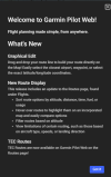
Garmin Pilot Web

Cool feature I've wanted on flight planning software that it has. Click on an airport, go to fuel and there's a button for sort for airports nearby by 100LL price. Use case for me is a long XC that has a fuel stop on the way. Lay out your route without the stop and click on an airport that is roughly halfway. Sort by price and find an airport to potentially fuel at.
GP has a fuel-price overlay that worked really well for me during a multi-day XC flight. Even color-coded by how outrageous the price is! Very simple to just see all of the prices on the map along the route of flight and plan for a stop at an appropriate point.
 
Garmin Pilot wasn't originally a Garmin product, it was an acquisition... And I can't remember what the company was before either.
Digital Cyclone (DCI)
Long-time product user since their original aviation weather app, Pilot My-Cast, and continued subscribing throughout. Re-named Garmin Pilot in 2012.
… if interested, article from 2013:
Behind the Apps: Garmin Pilot
 
Last edited:
Digital Cyclone (DCI)
Long-time product user since their original aviation weather app, Pilot My-Cast, and continued subscribing when it became Garmin Pilot.
… if interested, article from 2013:
Behind the Apps: Garmin Pilot
Thank you! I was looking at the Garmin page on Wikipedia after I posted that trying to figure it out and I guessed it was Digital Cyclone based on the timeframe, but that didn't ring a bell at all and they never mention Pilot. I do remember Pilot My-Cast.

The Digital Cyclone office for Garmin is in Chanhassen, MN, southwest side of the Twin Cities metro, near KFCM: https://www.google.com/maps/place/G...try=ttu&g_ep=EgoyMDI1MDQyOS4wIKXMDSoASAFQAw==
 
Since Garmin took over FltPlan Go, I’ve been on the lookout for an alternative that’s accessible online. The new Garmin Pilot Web looks promising, so I might give the Garmin Pilot app a try. The only thing that really bugs me is that they don’t bundle the Canada and U.S. subscriptions — feels like a missed opportunity for cross-border pilots.
 
Last weekend I planned a XC on GP on my Android phone and was frustrated as compared to the experience on my Android tablet. I actually searched to see if GP had a web interface. Two days later, waa-laa! It will be nice when it has more functional parity w/ the apps. I'd much prefer planning on a computer (vs tablet or phone).
 
Last edited:
I'm still trying to see the benefit of paying for a subscription to Garmin Pilot or Foreflight when Flightplan go is free and appears to work just as well. What am I missing by not spending my money?
 
I'm still trying to see the benefit of paying for a subscription to Garmin Pilot or Foreflight when Flightplan go is free and appears to work just as well. What am I missing by not spending my money?
For me, it's the integration and usability. I can create a flight plan on my iPad (and now on the web) and then, when I get into my plane, that plan is uploaded to my avionics seamlessly and in the same format I've been using on my iPad. GP also downloads and subsequently pushes routine updates to my avionics' databases, so I don't have to mess around with SD cards. The interface is intuitive (more so than FF, in my opinion) and does a fantastic job of keeping me aware of NOTAMs and TFRs (particularly important in the SFRA region). The avionics feed GP updates every second, including attitude, location, ADSB traffic, and engine parameters, all of which combine for useful tools in flight and an easy way to comprehensively review the flight (especially engine data) when back on the ground. All of that data is linked to logbook entries, including maps, in a native app on any device I care to use.

More edge-case, there's also an excellent simulator mode which allows me to link my iPad to my PC for flight simming. When I was planning my coast-to-coast, I was able to fly various routes in the simulator, and see GP reacting exactly as it would in flight. Great training device and when I finally flew the route in real life, it was like I'd already done it before.

Fltplan.com is a great resource. It's a little fiddly for my taste and lacks certain features (e.g., GP is showing a yellow "upcoming TFR" near where I'll be flying tomorrow, while Fltplan.com isn't showing anything there, even with the TFR layer turned on). I think it probably meets the basic needs of a lot of VFR pilots and is a completely reasonable option if it checks all the boxes for a particular aviator.

Given the sheer amount of money I spend on aviation, GP is an absolute drop in the bucket for the utility it gives me. For the price of gas on a decent cross-country, I get a year of a great product that makes flying easier and has been invaluable for maintenance. When my A&P shop wants to know what oil temps, CHTs, and so forth I'm seeing as we chase down an issue, I don't have to pull that from memory. I can show them graphs for all phases of flight, linking any parameter they care to examine. It's really something!

 
I'm still trying to see the benefit of paying for a subscription to Garmin Pilot or Foreflight when Flightplan go is free and appears to work just as well. What am I missing by not spending my money?

Does FPG sync with your EFB?

For me, I can use iflightplanner to plan a flight, get the briefing, and file on a 27” monitor the night before a flight.

When I (later) open my efb, the plan syncs with the EFB, lets me get an updated wx briefing then step to pre-flight.

I can also do all that on the EFB at the airport if I want, but if I’m doing an XC flight, I prefer the monitor’s real estate and HMI over a 10” tablet.

Everyone has preferences and values; whether they line up with yours is chance. Earlier in my life, I used skyvector and avare, because they’re both free and that was valuable to me. Now, I value the features with iFly enough to pay a reasonable amount for the subscription. If our plane had a flightstream, I’d probably move to FF simply for 2-way FP transfers with the GTN and the mature web-based planning tool.

In a few short years when I plan to do some part-time CFI/II work, I’ll likely abandon iFly and use both FF and GP since those are the 800-lb gorillas and I couldn’t see being a competent instructor if I had little to no experience with the tool(s) used by the majority of pilots.
 
No rubber banding capability that I can see. Maybe I haven't figured it out yet.

"Thank you for contacting Garmin International.

Currently the Garmin Pilot Website does not have the "Graphical Route Editing" (rubber band) feature.

I have added that suggestion and the one for zoom in/out buttons to the Feature Request Spreadsheet."
 
I'm looking for an even more basic feature: Activate a Flight so it shows up on the Maps. There is a button to create a Flight from the Maps Flight Plan box, but I don't see the reverse option anywhere. Does anyone have a hint on where the magic button for that got hidden?
 
I'm looking for an even more basic feature: Activate a Flight so it shows up on the Maps. There is a button to create a Flight from the Maps Flight Plan box, but I don't see the reverse option anywhere. Does anyone have a hint on where the magic button for that got hidden?

Create the trip, then activate it.
 
Create the trip, then activate it.
That works great in the iPad app. But where did they hide the Activate button on the web version? It’s probably in 96-point font so I am just not noticing it.
 
That works great in the iPad app. But where did they hide the Activate button on the web version? It’s probably in 96-point font so I am just not noticing it.

Feels like using the android version of GP, honestly. How G can deliver something as brilliant as SmartCharts nut can’t/won’t port feature parity across web/OS/platform is beyond me.
 
I'm looking for an even more basic feature: Activate a Flight so it shows up on the Maps. There is a button to create a Flight from the Maps Flight Plan box, but I don't see the reverse option anywhere. Does anyone have a hint on where the magic button for that got hidden?
I haven't seen it either. There is an "expand" button for the smaller map in the planning page. I've not seen a way to show a FP on the map page.
 
Lack of rubber banding for flight planning is a HUGE problem for me. So easy to modify a route in FF to reduce over water or miss airspace
 
Lack of rubber banding for flight planning is a HUGE problem for me. So easy to modify a route in FF to reduce over water or miss airspace
That's a standard feature in the iOS version of GP, so I imagine it's on the way. Surely must be one of their most requested features for the web version, I'd venture to guess.
 
Lack of rubber banding for flight planning is a HUGE problem for me. So easy to modify a route in FF to reduce over water or miss airspace
I do rough planning, like you describe here, in Skyvector. Then copy/paste the route into GP.
 
See post #50
Your point? Putting on the request list does not get it implemented.

G3X certified users have been asking for EGT equalize function for years. And still not implemented. And it has been on the experimental side for years.
 
Your point? Putting on the request list does not get it implemented.

G3X certified users have been asking for EGT equalize function for years. And still not implemented. And it has been on the experimental side for years.

Great point. So let’s just whine and b!tch about it on PoA and not even ask if they can do it. Solid plan for sure. Great work thanks for your service.
 
No rubber banding capability that I can see. Maybe I haven't figured it out yet.

"Thank you for contacting Garmin International.

Currently the Garmin Pilot Website does not have the "Graphical Route Editing" (rubber band) feature.

I have added that suggestion and the one for zoom in/out buttons to the Feature Request Spreadsheet."

Lack of rubber banding for flight planning is a HUGE problem for me. So easy to modify a route in FF to reduce over water or miss airspace

Your point? Putting on the request list does not get it implemented.

G3X certified users have been asking for EGT equalize function for years. And still not implemented. And it has been on the experimental side for years.

well that didn't age well now did it.

1771984089471.png
 
Update: Garmin Pilot on my iPhone has replaced Trip Planning with Flights, which works more like the Pilot Web version. That is to say, I can’t find the Activate command anymore. Not in either of the two adjacent … menus. Also, all my previously planned Trip Planning trips are absent.

There are other dumb things in this interface, but the loss of the Activate command is by far the most baffling.

Edit: The giant, blue "Start Flight" button was the one to activate it to the Flight Plan and Map pages.

So many other things remain baffling. Including the lack of this option on Pilot Web, the presence of multiple ... menus on the same page, the different places to enter fuel information, changing from "VFR" and "IFR" altitude filters to "500'" and "1000'" filters (which comes with it defaulting to a VFR altitude and IFR flight plan so far), the loss of the entry for cruise TAS (it always liked to assume my 310 is faster than it is so I had to enter that manually, but now I don't even know where the box went and the estimate table it gives it insane: 2300/20.0 ETE is 8+31 while 2300/21.0 is 2+13 for my flight tomorrow), etc.
 
Last edited:
Back
Top