Garmin GI275 HSI/CDI self test

turbosuper

Pre-takeoff checklist
Joined
Aug 3, 2021
Messages
130
Display Name
turbosuper
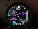
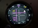
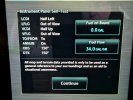
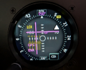
On the Garmin GTN750Xi Instrument Panel Self-Test page, it shows LCDI Half Left and VCDI Half Up, but the CDI is not half up or left on the GI275, it is more like a 1/4 deflection as shown below. Is this normal?

image000000.jpg
PXL_20260923_113425699.jpg
PXL_20260923_113423125.jpg
 
On the Garmin GTN750Xi Instrument Panel Self-Test page, it shows LCDI Half Left and VCDI Half Up, but the CDI is not half up or left on the GI275, it is more like a 1/4 deflection as shown below. Is this normal?

They're both correct.

The nav indicator is indicating 5° up/5° left (max deviation = 10°). It just looks odd because the scale is non-standard.

Nav indicators typically present with the edge of the center circle as 1°, which each dot being 2° deflection. However, Garmin uses the edge of the circle as 2°, and each dot thereafter = 2°.

The HSI scale is 5° per dot, with 10° max deflection.
 
Last edited:
The HSI is on a ADAHRS +AP 275 HSI and the CDI image is from a 275 base MFD unit. They are both hooked up via HSDB so I don't think there is any calibration that can be done.
 
I think the bigger issue is that the two are not in agreement. The HSI is indicating correctly (5° up/5° left, which is half scale deflection (max deflection = 10°, each dot being 5°)), but the nav indicator GI 275 is only indicating 3° up/3° left (each dot = 2°, with the edge of the center circle being 1°).
So you’re expecting the Nav CDI to be on the second dot laterally and vertically, signifying 5° and matching the HSI; is that right? That would make sense.
I’ve never really scrutinized them that closely as long as they come off center both ways and no flags are thrown.
 
The HSI is on a ADAHRS +AP 275 HSI and the CDI image is from a 275 base MFD unit. They are both hooked up via HSDB so I don't think there is any calibration that can be done.
I corrected my post.

They're both correct.

The nav indicator is indicating 5° up/5° left (max deviation = 10°). It just looks odd because the scale is non-standard.

Nav indicators (those made by King/Bendix-King anyway) typically present with the edge of the center circle as 1°, which each dot being 2° deflection (5 dots total either side of the circle), with max 10° deflection. However, Garmin uses the edge of the circle as 2°, and each dot thereafter = 2°. This is consistent with their analog GI 106 indicators.

The HSI scale is 5° per dot, with 10° max deflection.
 
Yeah, it's all showing as it should. The HSI "looks" correct, while the CDI does not because of the way Garmin treats the inner circle.

The indicators appear to be 1.5 out of 4 dots off course, but really they are 2.5 out of 5 dots, or 5 degrees out of 10, which of course is half scale.

Marked up in degrees:

1790608149631.png
 
So you’re expecting the Nav CDI to be on the second dot laterally and vertically, signifying 5° and matching the HSI; is that right? That would make sense.
I’ve never really scrutinized them that closely as long as they come off center both ways and no flags are thrown.
What I didn't realize when I typed that post was that the Garmin and the King nav indicators treat the center circle differently.

On a King/Bendix-King nav indicator, there are 5 dots either side of the circle, laterally and vertically, with 2° spacing. The center circle is a bit smaller, and its outer edges correspond with 1° deflection.

On a Garmin nav indicator, however, there are 4 dots either side of the circle, laterally and vertically, with 2° spacing. It also uses a larger center circle, and its edges correspond with 2° deflection. The first dot from the circle's edge is 4°, then 6/8/10.

Thus on the Garmin indicator, a needle deflection of 5° presents as Circle Edge + 1.5 dots. Whereas on the King/Bendix-King nav indicators, 5° presents as a needle deflection of Circle Edge + 2.5 dots.

I was thinking King/Bendix-King when I typed the post that you quoted.

On most HSI's, you only have 2 dots either side of center, each representing 5° of needle deflection (exceptions for King/Bendix-King KI 525, which still uses the 2° scale), but a 5° scale vertically).

When you're navigating via VOR or ILS, the needle deflection shows angular deviation (half scale deflection/2.5 dots = 5° off radial, for instance). When you're navigating via GPS, however, the needle deflection shows linear deviation in nautical miles, with the scale changing based on En Route (5nm full scale deflection for non-WAAS, 2nm full scale deflection for WAAS) and Terminal mode (1nm full scale deflection), and non-precision RNAV/GPS approaches (0.3nm full scale deflection). For WAAS approaches, it changes to angular deviation.

 
Last edited:
Back
Top