You are using an out of date browser. It may not display this or other websites correctly.
You should upgrade or use an alternative browser.
You should upgrade or use an alternative browser.
ForeFlight Lat/Long Coordinates
- Thread starter luvflyin
- Start date
eman1200
Touchdown! Greaser!
- Joined
- Mar 10, 2013
- Messages
- 18,881
- Location
- Oakland, CA
- Display Name
Display name:
Bro do you even lift
I didn't actually read it (what else is new) but maybe this will help:
you know you want to click here
you know you want to click here
luvflyin
Touchdown! Greaser!
Thanks. I tried some of those converters but it’s not working. I must be doing something wrong but I can’t see what.I didn't actually read it (what else is new) but maybe this will help:
you know you want to click here
- Joined
- Dec 5, 2010
- Messages
- 5,155
- Display Name
Display name:
GeorgeC
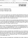
The image you posted appears to be from NFDD, which appears to use degrees-minutes-decimal seconds, e.g. DDMMSS.ssN/DDDMMSS.ssW.
from
So you'd need to convert it.
from
The following formats are supported for entering lat/long coordinates within ForeFlight:
* Decimal Degrees (DD.dd)
* Degrees, Minutes, Seconds (DD°MM'SS)
* Degree Minutes (DD°MM.mm)
So you'd need to convert it.
luvflyin
Touchdown! Greaser!
RussR
En-Route
Dropping the decimals off the seconds seems to be the quickest way with no conversion.
luvflyin
Touchdown! Greaser!
Ah Ha!! That worked. What it gives you back is 17TMF43449679 instead of the 41311504N/081404013W that was typed in. But that's the spot. ThanksDropping the decimals off the seconds seems to be the quickest way with no conversion.
- Joined
- Dec 5, 2010
- Messages
- 5,155
- Display Name
Display name:
GeorgeC
decimal degrees = (degrees) + (minutes / 60) + (seconds / 3600)Yeah, these are ForeFlights formats. I can’t seem to find a way to convert a 413115.04N/0814040.13W into one of those.
luvflyin
Touchdown! Greaser!
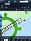
What @RussR said about dropping the decimal point worked. The given coordinate was 413115.04N/0814040.13W. I entered 41311504N/081404013W. ForeFlight decided it should be called 17TMF43449679. That’s the spot, it’s the Departure Reference Point.decimal degrees = (degrees) + (minutes / 60) + (seconds / 3600)

RussR
En-Route
What @RussR said about dropping the decimal point worked. The given coordinate was 413115.04N/0814040.13W. I entered 41311504N/081404013W. ForeFlight decided it should be called 17TMF43449679. That’s the spot, it’s the Departure Reference Point.
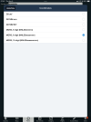
It returned 17TMF.... because you have MGRS 8-digit selected in your Settings. If you pick one of the other options, it will display it differently.
(And the DRP is always 2000 feet down the runway. It's used in several departure calculations and is deemed to be the earliest reasonable point an aircraft would become airborne.)
luvflyin
Touchdown! Greaser!
Ah. Got it. ThxIt returned 17TMF.... because you have MGRS 8-digit selected in your Settings. If you pick one of the other options, it will display it differently.
(And the DRP is always 2000 feet down the runway. It's used in several departure calculations and is deemed to be the earliest reasonable point an aircraft would become airborne.)


