Foreflight internet vs Stratus radar images

mikegreen

Pre-takeoff checklist
Joined
Jan 28, 2010
Messages
201
Location
Denver
Display Name

Display name:
mike g.
Does anyone know which is which in terms of base vs composite?

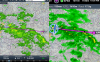
Ipad mini on the stratus and iphone 5 still on 4g showing the same area.. The iphone paints a much worse picture. I am thinking the internet radar is composite radar and the stratus returns are base.

Any idea which ATC sees?

thoughts?
 

Attachments

  • IMG_0691.PNG
    IMG_0691.PNG
    1,012.2 KB · Views: 59
  • IMG_0067.PNG
    IMG_0067.PNG
    1.3 MB · Views: 58
Those weather images are a full 10 minutes apart, so they should not be the same, and they don't really look *that* different (given the time span between images).
 
I disagree.
Look at the amount of yellow towards the end of the route.

The diff in timing was nothing - I just didnt get around to capturing the other screenshot while I was climbing out.
 
I don't understand your disagreement, Mike. The two units say that the last data update checks by FF are 10 minutes apart. That means, at least potentially that the NEXRAD information (assuming regional; continental updates are longer) can be up to 15 to 17 minutes apart. Even just the 10 minutes is more than enough time for the yellow to increase and then decrease again.

According to the FF manual, anyway, the data is the same whether internet or ADS-B from Stratus.
 
Mark, it was consistently different at the same time thru out the flight. Same with the return yesterday.

Does anyone know if ADS-B is base or composite? I got this from the FF site:
What Radar coverage is provided when ForeFlight Mobile is connected to the Internet?

ForeFlight Mobile displays composite reflectivity radar data for the continental United States, Alaska, Hawaii, Puerto Rico, Cuba, the Western Bahamas, and Canada.
 
another vote for calling those images identical for all practical purposes
 
Both of them are composite images. They are comprised of the base reflectivity pictures from all of the radars in the nexrad system.

Foreflight (internet) uses a higher resolution and 'smoothing' plus a little filtering. Basically it just looks prettier.

PS if you want a great app that you can use to play around with all of the different radar products, check out RadarScope. $10 when I bought it 2 years ago, but definitely worth it.
 
Last edited:
Here they are at the same scale. Maybe I'm crazy, but the one on the right last a ton more green.

Lets, for sake of internet argument, say they were at the SAME TIME.

attachment.php
 

Attachments

  • 2013-05-08_0936.png
    2013-05-08_0936.png
    1.3 MB · Views: 70
ok, my 10 year old is a lot taller than she was when she was 6, but for the sake of argument lets say both heights were measured at the same time:rolleyes:

Here they are at the same scale. Maybe I'm crazy, but the one on the right last a ton more green.

Lets, for sake of internet argument, say they were at the SAME TIME.
 
Both of them are composite images. They are comprised of the base reflectivity pictures from all of the radars in the nexrad system.

Foreflight (internet) uses a higher resolution and 'smoothing' plus a little filtering. Basically it just looks prettier.

PS if you want a great app that you can use to play around with all of the different radar products, check out RadarScope. $10 when I bought it 2 years ago, but definitely worth it.

Ren, thanks for a useful answer.

I know the basic (har har) diffs in base vs composite. Any idea what ATC sees? or can they adjust? Like I would do here:
http://radar.weather.gov/radar.php?rid=fsd&product=N0R&overlay=11101111&loop=no
(on top left, reflectivity composite or base)
 
Similar usefulness of data for this VFR pilot. So, for functionality I think they're the same.
 
Ren, thanks for a useful answer.

I know the basic (har har) diffs in base vs composite. Any idea what ATC sees? or can they adjust? Like I would do here:
http://radar.weather.gov/radar.php?rid=fsd&product=N0R&overlay=11101111&loop=no
(on top left, reflectivity composite or base)

Okay, I see your question now

I guess there are two 'composite' radar images.

The composite reflectivity image of a single radar station (as depicted in that link) is a composite of all the tilts of the radar. The base reflectivity is the lowest tilt, so you can (kinda) think of that as seeing what's hitting the ground. The higher tilts show what's up in the clouds. They combine all of these snapshots into one image. The advantage here is that a thunderstorm just maturing might show up as light rain on the base shot if it is close to the radar - but the composite would show it as a stronger return because there is more moisture up in the cloud.

I've always referred to the big national radar pictures you get as 'composite' but I am guessing you are wondering if they are a composite of the individual composite reflectivity images from the individual radar stations, or composites of the base reflectivity shots from all radar stations.

I'm gonna change my answer and go with composites of the composites. :rofl:
 
Last edited:
Mark, it was consistently different at the same time thru out the flight. Same with the return yesterday.

Does anyone know if ADS-B is base or composite? I got this from the FF site:
I think I gotcha - the differences showed up on the two units at exactly the same time; you're just providing a bad example (that shows a 10 minute spread).

In that case, I go with Ren's observation about the differences in depiction over an internet connection as opposed to ADS-B.

ADS-B is composite.
 
Back
Top