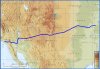
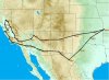
Well, low is a relative thing. I can tell you this, If you look at R-5107 on the ALB chart, you'll see that your two choices are around north at an altitude of 8500 minimum, or south through eastern NM all the way to El Paso. If you choose the northern route, make your way to The corona VOR.
From there, due west will take you over the Mongolon plateau to St Johns. Cheap gas, and use the courtesy car to get food. If you ask for it for longer, you can drive up through Petrified forest. A bleak, and bizzare landscape, you have to see to believe. Leave SJN and go west to Winslow area, overfly Meteor Crator. Turn slightly south and fly through Sedona canyon. You can stop at Sedona for gas and a meal. Keep west to Prescott valley at around 6500', and head over the big mine at Bagdad. Stop in at Lake Havasu. Rent a jet ski for half a day, and tootle up the lake into Topock gorge, beautiful.
From Havasu, things get pretty desert and boring right into LA area. The Santa Paula airport is pretty neat, and they have good Citabria service if you need anything. On the way back, I don't know how far north you're going, but anything past Bakersfield, and east through the Kern Valley, is gonna get very high in altitude quickly. Inyokern is due east, and from there, you have to jog around some R areas to La Vegas(why not?). If you want an interesting side trip you could go north from Inyokern to Furnace Creek and land at -215 feet elevation. Gas gets hard to come by, so keep plenty of fuel with you. May have to carry some in a can, or make arrangements in advance.
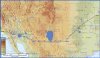
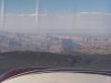
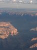
Out of Vegas, basically follow the Colorado river NE. Watch for the minimum altitudes over the Grand Canyon. Stop at Page, and from there, fly over lake Powell which is spactacular, up to Carl Black. Jog around through Monument Valley. From teh four corners area, you have to make a decision. If you want to stay low, you're stuck going back east over the same mongolon plateau. Of you want to get over 10,000', you can continue to follow the Colorado river through some spactacular, but rough high country. Turn right to Hopkins airport at the town of Nucla. Stay up Mckenzie creek going west, then turn north a bit to the Black mesa Gunnison area.
Up to now, you can stay below 10,000 feet, but you'll be close to the ground in some area. Just go around stuff that you can't go over. Landmarks are easy, and it's beautiful flying, especially in the mornings. If you stay in Gunnison, you'll wnat to see the Black Canyon of the Gunnison, it's straight down for a mile, and much narrower than the grand canyon. Out of Gunnison, you'll have to go up to 12,000 for at least a few minutes. Monarch pass is 11,312 and I like a 1000 foot cushion. fortunately, Monarch is a fairly steep pass, and you can get up and down into Salida without too much time at altitude. From here, it's all down hill.
You can either stay down the Arkansas valley to Pueblo, or stay south through Wet Mountain pass, and then into Perry Stokes airport. It's pretty darn flat from there to home, so you'll see lots of scrub and grass.
I've flown this area quite a bit over the years, and it can be stunning. It can also be very dangerous. Use flight plans, and try to fly your plan. FF is spotty, non-existant in the mountains when you're down low. I really suggest you take one of those collapsable plastic cans, and use it four spare fuel on some of the legs. Carry emergeny stuff too.
The southern route to El Paso doesn't have much to see. Carlsbad Caverns is down there, and then not much until you get near Phoenix.
")