RIlls
Filing Flight Plan
- Joined
- Nov 6, 2011
- Messages
- 24
- Display Name
Display name:
RIlls
I have a question about different information in Foreflight vs a sectional chart re the floor of Class E airspace. This is mainly an academic exercise but could have real world implications.
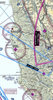
Let’s say I am going in or out of Little River CA VFR. Looking at a sectional chart on Foreflight (see attached) I would assume that class E starts at 700 agl around the airport based on the magenta ring. This would be my interpretation if I just had a paper chart. Nothing in the AF/D would tell me differently.
But with Foreflight, if I select the aeronautical map overlay it adds a whole new area with an indication that class E starts at 5,500 feet mal. (See attached).
So is the airspace above 700 feet above the airport Class G or E?
I think the significance of the distinction is that for day flight above 1200 agl the required visability would be 1 mile if this is G airspace and 3 miles if E airspace. Same distances from clouds. But what about the airspace between 700 feet and 1200 in this situation? Only 1 mile and clear of clouds if the class E does not start until 5500 msl.
The distinction could be important if you climb to 900 feet AGL under a 1000 foot ceiling. If the magenta transition area ring controls, you are in Class E above 700 feet and do not have the required cloud clearance. If the depiction of 5500 foot start of class E controls, you are fine.
This scenario is probably not uncommon at this airport. There is often a marine layer that rolls in over the airport from the ocean but the weather is severe clear a mile to the east.
My other question is about Foreflight vs a sectional chart. Why does this 5500 class E airspace show up with the aeronautical overlay but not on a regular sectional? Come to think of it, it you use the aeronautical overlay without a sectional underneath it, you don’t get a depiction of the magenta 700 foot transition areas anywhere on the chart.
Perhaps I am not up to speed on airspace or chart interpretation- if so I am sure I will hear about it") I use the aeronautical overlay over a sectional base, so I get all of this info, but I could see some confusion if you used only a sectional or only the aeronautical map.
I use the aeronautical overlay over a sectional base, so I get all of this info, but I could see some confusion if you used only a sectional or only the aeronautical map.
Anyone have any thoughts on this?
Let’s say I am going in or out of Little River CA VFR. Looking at a sectional chart on Foreflight (see attached) I would assume that class E starts at 700 agl around the airport based on the magenta ring. This would be my interpretation if I just had a paper chart. Nothing in the AF/D would tell me differently.
But with Foreflight, if I select the aeronautical map overlay it adds a whole new area with an indication that class E starts at 5,500 feet mal. (See attached).
So is the airspace above 700 feet above the airport Class G or E?
I think the significance of the distinction is that for day flight above 1200 agl the required visability would be 1 mile if this is G airspace and 3 miles if E airspace. Same distances from clouds. But what about the airspace between 700 feet and 1200 in this situation? Only 1 mile and clear of clouds if the class E does not start until 5500 msl.
The distinction could be important if you climb to 900 feet AGL under a 1000 foot ceiling. If the magenta transition area ring controls, you are in Class E above 700 feet and do not have the required cloud clearance. If the depiction of 5500 foot start of class E controls, you are fine.
This scenario is probably not uncommon at this airport. There is often a marine layer that rolls in over the airport from the ocean but the weather is severe clear a mile to the east.
My other question is about Foreflight vs a sectional chart. Why does this 5500 class E airspace show up with the aeronautical overlay but not on a regular sectional? Come to think of it, it you use the aeronautical overlay without a sectional underneath it, you don’t get a depiction of the magenta 700 foot transition areas anywhere on the chart.
Perhaps I am not up to speed on airspace or chart interpretation- if so I am sure I will hear about it
I use the aeronautical overlay over a sectional base, so I get all of this info, but I could see some confusion if you used only a sectional or only the aeronautical map.Anyone have any thoughts on this?
Attachments

Last edited:
