tonycondon said:
ha kent, i wasnt sure the pictures would upload and didnt want to mess with it. oh well. hope you enjoyed it
Note that only 20 people have looked at it so far, and I'm two of 'em. (File was corrupted the first time.)
So, for everyone else's convenience, here it is, pics and all:
(bonus: Pictures are now more visible without Word being "helpful" and downsizing them, and they're smaller to boot!)
EDIT: Still difficult to read in the quote box with all the italics. So, note that Tony wrote everything below this line.

Many of you read my flight report from my last attempted cross country flight with Matt Michael in his Lark. Last June, he and I set the un-official Multi-Seat Free Distance Record at about 10 miles. We decided to try and best that last Saturday, April 22.
We had been keeping a close eye on the weather all week, and everything seemed to drop into place. Dr. Jacks Blipmap forecasts were promising. Friday was spent with Matt readying the glider and trailer, and me working and driving to Ames. While the rest of the Iowa State campus was celebrating the comeback of VEISHA by ensuring they would forget the comeback of VEISHA, I was getting the best nights sleep I could.
Saturday morning had Matt and me at the airport around 9 AM making final preparations. The trailer and car had to be ready to go for our eventual crew, if needed and we had to get the glider in order for the flight ahead. Mounting the camera, getting the barograph installed as well as the usual food and water and other support equipment took its time. We kept a close eye on the sky and kept moving. We also spent a good portion of this time trying to concoct a game plan for the flight. A morning call to Flight Service had yielded winds forecast out of the Northwest at 10-15 knots. Matt was really focused on trying to get a record and preferably making it back to Ames to avoid having to derig the glider and then put it back together Sunday morning. I just wanted to go cross country.
As usual, the conditions of the day dictated our decision. Around noon, the first cumulus of the day started to pop up, and we could see that the place to be was not over Ames. Beautiful clouds were within sight to the North, probably about 10 or 15 miles away. Clouds were present around the airport, but were scattered around and didn’t look very promising. We decided we would start heading North up I-35 and then go where the conditions were good. We pulled down to the runway and made final preparations.
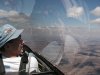
Darrel Mullins was our tow pilot and Paul McIlrath and Paul Kaufmann helped get us launched. The barograph was turned on before takeoff and the tow went smoothly. We got off at about 2000 feet above ground in some decent lift at 12:56 PM. We started working to get high above the airport. It would be our first turn point so we needed to get as high as possible south of it.
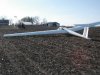
We struggled over town for a while and got down to 2500 feet above sea level but found some lift at about 500 feet per minute and were on our way up through 5000 feet by 1:20. We soon got our picture of the Ames airport and were headed north. By 1:40 we had made it to Roland, about 10 North of Ames and were at 4500 feet and were getting closer to the good looking clouds to the north.
Another 10 miles or so to the NNE and we were over the town of Radcliffe and had reached the excellent conditions as we were now at over 7000 feet. It was in this portion of the flight that we reached our maximum altitude at cloud base of 8000. At this vantage point, we started formulating our the rest of our plan. We knew that if we wanted a downwind run home to Ames so we needed to head northwest. This choice was easy to make as the clouds were streeting from Northwest to Southeast in our area. We got within about 5 miles of the Iowa Falls airport. At one point we got kind of low in this area, down to about 3500 feet, but made a good climb and got back to cloud base. Then turned directly upwind and flew the streets.
We cruised upwind between cloud base at about 7500 and down to about 6000. Stopped occasionally to circle but tried to climb straight ahead as much as possible. The street we were on seemed to start to overdevelop. It was getting pretty shady and cool around us, but we were still getting decent lift so we continued to Clarion. We snapped our picture of Clarion at about 3:50 and headed directly west. Our plan was to go to Humboldt and possibly Pocahontas depending on conditions. That would place us upwind of Ames for an easy trip home.
The trip from Clarion initially involved very little turning, and the Barograph showed that. We were past the Eagle Grove airport, about 8 miles west, in 12 minutes with only a 300 foot altitude loss. The next 7 or 8 miles got us within 7 miles of Humboldt, but down to 4000 feet and we were starting to get a little worried.
By now it was about 4:15 and we were still East of Humboldt 5-7 miles, working very weak lift trying to make it to the airport to get a picture and get back to Ames. Matt made two masterful low saves here, both about 1500 AGL. At one point we noted that the averager on the palm was showing .3 knots up, only 30 feet per minute! Throughout this period of the flight, I was mostly scoping out fields to land in and looking for any sign of lift. We saw a few hawks near us and managed to stay afloat. There were several good sized dust devils to our west about 5 miles. One looked like a tornado, reminded me of something from the desert southwest. By 5:20 we were still struggling to make it to the airport for a picture and were within 2 miles of the airport. Finally at 5:25 after more than an hour long struggle we got a picture of Humboldt from about 3300 feet and headed downwind. We knew there was some lift still out there, after seeing at least 3 dust devils in the area, and the sky still had good clouds. We hoped for an easy trip back home.
It turned out that the day was totally dying. The best lift we encountered in the next 8 miles was 100 feet per minute. Even that was not steady and pretty choppy. The cores were impossibly small and everything was generally unworkable. Being blown downwind almost immediately put us out of range of the Humboldt Airport, especially since we would have had to approach it into the wind and over town. I was once again back in my role of scoping out signs of lift and landing spots. Matt was working the lift to the best of his abilities, but sadly I was watching the altimeter unwind. Just before we were about to give up I spotted a Vulture a quarter mile north of us. I believe he was there just to torment us. We turned final for the field I had chosen, a freshly planted bean field, and made a nice landing with a slight crosswind and rolled as close to the house as possible.
Now the easy part was over and we had to figure out how to get home. Immediately we started calling everyone we knew in Ames to find someone to come get us. Unfortunately Dave Hill was unable to come get us, but his wife Sharon volunteered to come get us. While we waited Matt and I met the nice folks we had landed next to, Dave and Nikki Hanna. Dave was kind enough to bring his tractor out in the field and pull the glider to a driveway where we could derig. After this we waited for Sharon to arrive. She arrived about 830 and we quickly got to work with Daves help to get as much work done as possible before the sun set completely. The derig went very well and both Matt and I noted how easy it was compared to earlier attempts. We finished about 10:00 PM and were headed back to Ames. A quick stop in Fort Dodge for McDonald’s gourmet dinner and check the trailer, followed by a good nap for Sharon and I, and we were back in Ames.
Total flight time was 4 hours and 53 minutes. We covered about 135 kilometers. While my last cross country flight was more drifting with the wind until we couldn’t maintain altitude anymore, this flight finally put to use all the theory I have been learning and teaching about speed to fly and cross country decision making. As far as the level of challenge and reward, I firmly believe that no other form of flying compares.