tonycondon
Gastons CRO (Chief Dinner Reservation Officer)
Here it is folks, I tend to get a little windy with this stuff, sorry:
The soaring is always good during the week. Thermals seem to be naturally scared of weekends, apparently they get tired of overuse. Wednesday August 30 was forecast to have killer conditions throughout the Midwest, but alas, I had to go to class in the afternoon. Several club members had some great flights. Paul Kaufman, Darrel Mullins, and Sky King Mcilrath all worked good lift up to nearly 6000 feet MSL. Meanwhile I sat on the ground and watched. The forecast for the next day was looking good though. I had a friend, Jordan Birkholz, help me assemble the Cherokee on Wednesday afternoon and spent much of the evening getting the trailer and glider ready for a cross country adventure. Winds were forecast to be blowing to the west, turning northwest, boundary layer height was up around 6000 feet and clouds were predicted. Things were looking good.
Terry Lankford (My Hero) offered to tow me at 1 pm on Thursday. I got out of class at 12:15 and raced to the airport. Matt Michael helped me do a positive control check on the ship and make final preparations. I pulled down to the runway. I was slightly delayed but launched at 1:20. Terry pulled me into some good looking lift and at 1800 AGL I got off tow. The lift (as usual) ended up being weaker than expected but I notched the barograph and started to climb.
My initial limb was to about 3000 feet and I started to head northwest. My goal for the day was to make it to Estherville, IA, my hometown. I was looking forward to seeing my family, showing them the glider, and eating some pizza. Matt radioed my soon after I departed to see what my plan was. I told him I was going straight out and not coming back. He responded that he would be unable to chase as he needed to do some work, but I should call him when I landed. No problem. Turns out he was so excited about my flight he spent all afternoon monitoring the weather and trying to figure out my status. He might as well have chased. I soon found myself on the Northwest side of Ames, and the altimeter was still unwinding. It was quite disheartening to have to pick out a field already, just in case. Matt was still trying to talk to me and I responded with “Getting a little low now, need to climb, no time to talk” He was getting a little worried that my day was going to be really short. I managed to hook a good thermal though and back up to 3500 feet I went. Whew! I continued to the Northwest, headed for the Fort Dodge area. Reviewing the barograph trace confirms that I cruised in the strength band between 3 and 4000 for this phase of the trip. After an hour, I was half way the Fort Dodge.
I was right on schedule. I only was counting on 4 hours of flying. Of course, the thermals would probably be working after 5:30 but I didn’t want to have to depend on them. So I needed to be half way to Fort Dodge by 1 hour elapsed, over Fort Dodge at 2 hrs, then ¾ the way to Estherville by 3 hrs. I actually hit all these benchmarks right on. As I neared Fort Dodge airport, I tuned in their traffic frequency and was reminded that the airport hosts a huge skydiving event every Labor Day. There were two airplanes and a helicopter flying jumpers, with people falling continuously. I hooked a good thermal off of town that I rode to nearly 5000 feet and headed around west side of airport (downwind side). The clouds looked better in that direction anyway. In fact, for almost the entire trip I was flying right on the edge of the cumulus clouds. To the east, it was blue, to the west the sky was full of Cu’s. I stayed on the boundary and experienced long cruises in 4-600 foot per minute sink in the blue between some scraggly looking cumulus clouds. Cloud base and climb rates were improving as I continued on.
I saw the helicopter, a King Air jump plane, a regional airline flight and two skydivers (under canopy) during my flight past Fort Dodge. Talk about a diverse traffic flow! Continuing on, I was now cruising between 3500 and 4500 feet. I passed a Monarch Butterfly west of Humboldt and saw a few Hawks and Barn Swallows. All were a welcome sight. I arrived over Emmetsburg, about 20 miles south of Estherville, at 3 hours elapsed time. I was feeling pretty good about my situation. I caught a good thermal off the new Ethanol plant there and rode it to 5100 feet, my highest altitude. I spent a lot of extra time trying to get a little higher, as I remembered my low point in Ames to be 2200 and was trying to get the Silver Altitude gain. The Barograph trace confirms that I was a couple hundred feet short. I left the comfort of being local to the Emmetsburg Airport and pressed on to the north. I figured I needed two more climbs to 5000 or so and I would have it made. The next thermal I caught only brought me back up to 4000. I also started to notice that some high cirrus was moving in and was just about ready to block out the sun. Crap. It was decision time. I considered heading more northeast, trying to stay in the sunlight and hoping for a hole to cut back through the shadow, or I could try to make it before everything got shut down. I looked ahead and saw a few scraggly cumulus clouds in the shade about 5 miles ahead, then I saw a fairly large hog confinement a few miles in front of me. I was reminded of a day flying around at 1000 feet and then suddenly smelling a hog confinement that I was over. I thought maybe I could get a thermal off that and then work my way north. As I was headed toward that I noticed that there were a few more clouds up ahead now. Interesting, I figured everything was dying up there. I made the fateful decision to head towards the clouds. I caught some zero sink a little above 3000 feet and pressed on. Got down to 2500 and caught another little thermal, but only got a couple hundred feet out of it. I could notice it was darker and cooler out and I was beginning to pick out fields. I found an abandoned farmhouse with an empty field next to it. Apparently it had not been planted, and was full of weeds and grass, in bunches. I thought two things about it. One was a good place to land. Two was I could get a thermal off the stand of trees or all the black dirt. There was a little something coming off from it but I couldn’t figure it out fast enough, but did find a little zero sink. Finally I had to give up. I chose to land on the driveway to the house to provide ready access. Also with the bunches of weeds in the field, it did not look very inviting.
I flew a pattern for the driveway, continuously evaluating the decision. There were a couple small bushes up by the road that I would have to clear and corn was on the left side, but plenty of room was available for wing clearance. As I came down everything was looking pretty good. It turned out that the driveway was rougher than expected and I think I caught the nose skid in the grass between tire tracks and got turned sideways. The driveway was also built up from the field about 2 feet and I slid off the side. I was not too happy with myself but the landing was good enough and the only damage was a rip in the fabric in a twice previously torn spot. I immediately called Matt, telling him I had come up 7 miles short of Estherville and everything was OK. He told me that a friend, Chris Jones, had offered to crew, so I called him and he agreed to start out for me. I then called several members of my family. I managed to get to show off the glider to my Aunt and Uncle and their kids, my Grandma, and my Step mom Jody and little brother and sister. I was very thrilled to make it as far as I did and it was great to get to show off the Cherokee. I still got to get a great Woody’s Pizza. Chris got to Estherville about 930 and we headed out to the landing site. By 1030 the ship was secured in the trailer and we were off. Jody and the kids helped derig and stocked Chris and I up with rations for the drive home.
The stats came out to a distance of 91 Nautical Miles, which equates to 169 kilometers. I got the Silver distance in the bag, came up just short of Silver Altitude. I’m sure glad I remembered to bring the Barograph! Duration was 3 hours 40 minutes, which is well over an hour longer than my longest Cherokee flight. Now I can’t wait for a booming day this fall so I can get Gold Distance and Silver Altitude/Duration!
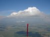
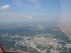
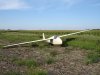
Pictures are
1) Right after first big climb to near cloudbase North of Boone
2) Fort Dodge Regional Airport
3) Where it stopped. When it did stop the tail was still up on the driveway but I had already rotated it down to the field so I could tie the thing down.
The soaring is always good during the week. Thermals seem to be naturally scared of weekends, apparently they get tired of overuse. Wednesday August 30 was forecast to have killer conditions throughout the Midwest, but alas, I had to go to class in the afternoon. Several club members had some great flights. Paul Kaufman, Darrel Mullins, and Sky King Mcilrath all worked good lift up to nearly 6000 feet MSL. Meanwhile I sat on the ground and watched. The forecast for the next day was looking good though. I had a friend, Jordan Birkholz, help me assemble the Cherokee on Wednesday afternoon and spent much of the evening getting the trailer and glider ready for a cross country adventure. Winds were forecast to be blowing to the west, turning northwest, boundary layer height was up around 6000 feet and clouds were predicted. Things were looking good.
Terry Lankford (My Hero) offered to tow me at 1 pm on Thursday. I got out of class at 12:15 and raced to the airport. Matt Michael helped me do a positive control check on the ship and make final preparations. I pulled down to the runway. I was slightly delayed but launched at 1:20. Terry pulled me into some good looking lift and at 1800 AGL I got off tow. The lift (as usual) ended up being weaker than expected but I notched the barograph and started to climb.
My initial limb was to about 3000 feet and I started to head northwest. My goal for the day was to make it to Estherville, IA, my hometown. I was looking forward to seeing my family, showing them the glider, and eating some pizza. Matt radioed my soon after I departed to see what my plan was. I told him I was going straight out and not coming back. He responded that he would be unable to chase as he needed to do some work, but I should call him when I landed. No problem. Turns out he was so excited about my flight he spent all afternoon monitoring the weather and trying to figure out my status. He might as well have chased. I soon found myself on the Northwest side of Ames, and the altimeter was still unwinding. It was quite disheartening to have to pick out a field already, just in case. Matt was still trying to talk to me and I responded with “Getting a little low now, need to climb, no time to talk” He was getting a little worried that my day was going to be really short. I managed to hook a good thermal though and back up to 3500 feet I went. Whew! I continued to the Northwest, headed for the Fort Dodge area. Reviewing the barograph trace confirms that I cruised in the strength band between 3 and 4000 for this phase of the trip. After an hour, I was half way the Fort Dodge.
I was right on schedule. I only was counting on 4 hours of flying. Of course, the thermals would probably be working after 5:30 but I didn’t want to have to depend on them. So I needed to be half way to Fort Dodge by 1 hour elapsed, over Fort Dodge at 2 hrs, then ¾ the way to Estherville by 3 hrs. I actually hit all these benchmarks right on. As I neared Fort Dodge airport, I tuned in their traffic frequency and was reminded that the airport hosts a huge skydiving event every Labor Day. There were two airplanes and a helicopter flying jumpers, with people falling continuously. I hooked a good thermal off of town that I rode to nearly 5000 feet and headed around west side of airport (downwind side). The clouds looked better in that direction anyway. In fact, for almost the entire trip I was flying right on the edge of the cumulus clouds. To the east, it was blue, to the west the sky was full of Cu’s. I stayed on the boundary and experienced long cruises in 4-600 foot per minute sink in the blue between some scraggly looking cumulus clouds. Cloud base and climb rates were improving as I continued on.
I saw the helicopter, a King Air jump plane, a regional airline flight and two skydivers (under canopy) during my flight past Fort Dodge. Talk about a diverse traffic flow! Continuing on, I was now cruising between 3500 and 4500 feet. I passed a Monarch Butterfly west of Humboldt and saw a few Hawks and Barn Swallows. All were a welcome sight. I arrived over Emmetsburg, about 20 miles south of Estherville, at 3 hours elapsed time. I was feeling pretty good about my situation. I caught a good thermal off the new Ethanol plant there and rode it to 5100 feet, my highest altitude. I spent a lot of extra time trying to get a little higher, as I remembered my low point in Ames to be 2200 and was trying to get the Silver Altitude gain. The Barograph trace confirms that I was a couple hundred feet short. I left the comfort of being local to the Emmetsburg Airport and pressed on to the north. I figured I needed two more climbs to 5000 or so and I would have it made. The next thermal I caught only brought me back up to 4000. I also started to notice that some high cirrus was moving in and was just about ready to block out the sun. Crap. It was decision time. I considered heading more northeast, trying to stay in the sunlight and hoping for a hole to cut back through the shadow, or I could try to make it before everything got shut down. I looked ahead and saw a few scraggly cumulus clouds in the shade about 5 miles ahead, then I saw a fairly large hog confinement a few miles in front of me. I was reminded of a day flying around at 1000 feet and then suddenly smelling a hog confinement that I was over. I thought maybe I could get a thermal off that and then work my way north. As I was headed toward that I noticed that there were a few more clouds up ahead now. Interesting, I figured everything was dying up there. I made the fateful decision to head towards the clouds. I caught some zero sink a little above 3000 feet and pressed on. Got down to 2500 and caught another little thermal, but only got a couple hundred feet out of it. I could notice it was darker and cooler out and I was beginning to pick out fields. I found an abandoned farmhouse with an empty field next to it. Apparently it had not been planted, and was full of weeds and grass, in bunches. I thought two things about it. One was a good place to land. Two was I could get a thermal off the stand of trees or all the black dirt. There was a little something coming off from it but I couldn’t figure it out fast enough, but did find a little zero sink. Finally I had to give up. I chose to land on the driveway to the house to provide ready access. Also with the bunches of weeds in the field, it did not look very inviting.
I flew a pattern for the driveway, continuously evaluating the decision. There were a couple small bushes up by the road that I would have to clear and corn was on the left side, but plenty of room was available for wing clearance. As I came down everything was looking pretty good. It turned out that the driveway was rougher than expected and I think I caught the nose skid in the grass between tire tracks and got turned sideways. The driveway was also built up from the field about 2 feet and I slid off the side. I was not too happy with myself but the landing was good enough and the only damage was a rip in the fabric in a twice previously torn spot. I immediately called Matt, telling him I had come up 7 miles short of Estherville and everything was OK. He told me that a friend, Chris Jones, had offered to crew, so I called him and he agreed to start out for me. I then called several members of my family. I managed to get to show off the glider to my Aunt and Uncle and their kids, my Grandma, and my Step mom Jody and little brother and sister. I was very thrilled to make it as far as I did and it was great to get to show off the Cherokee. I still got to get a great Woody’s Pizza. Chris got to Estherville about 930 and we headed out to the landing site. By 1030 the ship was secured in the trailer and we were off. Jody and the kids helped derig and stocked Chris and I up with rations for the drive home.
The stats came out to a distance of 91 Nautical Miles, which equates to 169 kilometers. I got the Silver distance in the bag, came up just short of Silver Altitude. I’m sure glad I remembered to bring the Barograph! Duration was 3 hours 40 minutes, which is well over an hour longer than my longest Cherokee flight. Now I can’t wait for a booming day this fall so I can get Gold Distance and Silver Altitude/Duration!
Pictures are
1) Right after first big climb to near cloudbase North of Boone
2) Fort Dodge Regional Airport
3) Where it stopped. When it did stop the tail was still up on the driveway but I had already rotated it down to the field so I could tie the thing down.