Favorite/Most Difficult IAP's?

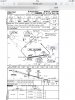
Here are a couple of 1:24,000 topos of Aspen. This makes it apparent that circling to the east is what professionals do and, in fact, is what the tower sometimes directs for spacing when weather permits:

http://www.terps.com/ase

As you know, there are no circling restrictions on the approach chart. For clarity, you're talking about descending below circling minimums in an area where there's a high plateau. If any pilot, professional or otherwise, intends to make right traffic for 33 that would be the prudent place to let down. But we've been talking about climbing from below MDA on a straight-in to rwy 15. In that case the prudent thing would be to hug the slopes on the right as much as is safe before commiting to a turn to the downwind. Your topo map shows how much extra lateral room can be had after clearing the posted elevations by a safe margin.

dtuuri
 
Wait. So you mean someone who routinely flies in to ASE actually knows what's going on vs someone who flew in there once 40 years ago with some hearsay knowledge?

I am shocked, I tell you. Shocked!

Why don't you follow her to ASE? (Hope you'll like the skiing at UKI.)

dtuuri
 
As you know, there are no circling restrictions on the approach chart. For clarity, you're talking about descending below circling minimums in an area where there's a high plateau. If any pilot, professional or otherwise, intends to make right traffic for 33 that would be the prudent place to let down. But we've been talking about climbing from below MDA on a straight-in to rwy 15. In that case the prudent thing would be to hug the slopes on the right as much as is safe before commiting to a turn to the downwind. Your topo map shows how much extra lateral room can be had after clearing the posted elevations by a safe margin.

dtuuri

Actually, landing on 33 is all but prohibited for jets.

And, you are correct, what I am referring to is below circling MDA. And, even if someone wants to circle at MDA, the tower will direct them to circle east.

Further, in the unusual situation where weather is a bit above circling minimums, pilots often cannot get down in time to land straight in (as per the AIM at tower airports) so the tower tells them to circle east for landing.
 
Can we get back to posting approach plates?
 
Last edited:
Actually, landing on 33 is all but prohibited for jets.
Here's a picture from a right hand base leg for 33 (ok, it was from somebody's deck, note the tree in the foreground).
Aspen.jpg
During a go around, before turning this way on a crosswind for 15 (with a probable tailwind) it pays to steal as much room as those hills on the other side will allow first.

dtuuri
 
Talking about interesting plates and associated puzzles ... by the way FAA lists Missoula as one of those airports requiring special skills.

Perhaps I am missing something, could you tell me why in this ILS approach minimum visibility is charted as 7 miles!!

Yes, there is another, better version of this ILS approach to MSO for those that have better climb performance however the airport also has non-precision GPS circling approach (no WAAS needed) where visibility requirements are much more modest (slightly over 1 m) and no special climb performance is required. So where is this 'extreme' 7 miles coming for??

http://155.178.201.160/d-tpp/1412/00266IY11.PDF
 
Last edited:
Talking about interesting plates and associated puzzles ... by the way FAA lists Missoula as one of those airports requiring special skills.

Perhaps I am missing something, could you tell me why in this ILS approach minimum visibility is charted as 7 miles!!

Yes, there is another, better version of this ILS approach to MSO for those that have better climb performance however the airport also has non-precision GPS circling approach (no WAAS needed) where visibility requirements are much more modest (slightly over 1 m) and no special climb performance is required. So where is this 'extreme' 7 miles coming for??

http://155.178.201.160/d-tpp/1412/00266IY11.PDF

Look at the DH.

3° GS 1900DH = 36,254 ft horizontally/5280 = 6.9 sm.
 
Perhaps you are right, but it only shows how a precision approach in many cases can be overly restrictive, or shall we say 'uninviting'. There is circling RNAV(GPS) to this airport with MDA only at 1330 AGL and visibility at 1.25.
 
Talking about interesting plates and associated puzzles ... by the way FAA lists Missoula as one of those airports requiring special skills.

Perhaps I am missing something, could you tell me why in this ILS approach minimum visibility is charted as 7 miles!!

Yes, there is another, better version of this ILS approach to MSO for those that have better climb performance however the airport also has non-precision GPS circling approach (no WAAS needed) where visibility requirements are much more modest (slightly over 1 m) and no special climb performance is required. So where is this 'extreme' 7 miles coming for??

http://155.178.201.160/d-tpp/1412/00266IY11.PDF

On any approach with vertical guidance (ILS, LPV, LNAV/VNAV) the visibility minimum must not be less than the distance from the DP Point to the runway threshold.
 
On any approach with vertical guidance (ILS, LPV, LNAV/VNAV) the visibility minimum must not be less than the distance from the DP Point to the runway threshold.
That's actually not quite correct, not necessarily all the way to the threshold, if runway is equipped with approach light system this distance could be in fact less, there are many examples of that.
 
That's actually not quite correct, not necessarily all the way to the threshold, if runway is equipped with approach light system this distance could be in fact less, there are many examples of that.

No, it is correct. If the approach lights are operative then, typically the required visibility is reduced by 1/2 s.m. Nonetheless the basic measurement before any ALS credit, is always to the runway threshold.

Note that at MSO no ALS credit is given on the ILS Y.
 
Last edited:
If the approach lights are operative then, typically the required visibility is reduced by 1/2 s.m..
Wrong, the opposite is true, the basic visibility is stated but with ALS inop it has to be increased by certain amount.
Also lights or no lights there are example when the formula of yours doesn't apply, for example RNAV(GPS) X RWY 1 at JAC. If your principle held the required visibility should have been around 4 miles but only 2 is required for the LPV approach.

BTW, this approach (and this issue) is under the AOPA microscope in its "IFR Chart Challenge".
 
Wrong, the opposite is true, the basic visibility is stated but with ALS inop it has to be increased by certain amount.
Also lights or no lights there are example when the formula of yours doesn't apply, for example RNAV(GPS) X RWY 1 at JAC. If your principle held the required visibility should have been around 4 miles but only 2 is required for the LPV approach.

It's not my principle. :)

It's all covered in Chapter 3 of FAA Order 8260.3b.

You are missing the note on the LPV minimums for the JAC RNAV X Rwy 1, which states, "Fly visual to airport." (both in the plan and profile views of the FAA chart.) That provision provides relief from the geometric minimums from the DA point to the runway. Subsequent to the time that procedure was published Flight Standards no longer allows fly visual to airport with 2 miles visibility. When the procedure is next revised it will be 3 miles if Flight Standards approves "fly visual to airport," or 3 1/2 miles if Flight Standards does not approve 'fly visual to airport." (and they won't since the HAT is less than 1,000 feet.)

"Fly visual to airport" is generally poorly understood by pilots.

Here is the pertinent language from Chapter 3 of 8260.3b:

Visibility greater than 3 SM.

Where the HATh is 1000 ft or higher, 3 SM visibility may be established with Flight Standards approval when the procedure is annotated “Fly Visual to Airport.”

Note 1: “Fly Visual to Airport” provides relief from visual reference requirements specified in Part 91.175, and related rules such as 121.651, 135.225, and 125.381. This option will only be approved where deemed safe and operationally beneficial.
 
Doesn't work for non-members of AOPA.

Yes, I was hoping most PoA'ers would have access, but obviously not everyone does.
Thank you for the clarification of the "fly visual" part of that approach. When taking the AOPA RNAV quiz a while back, I felt that segment was quite confusing: we are used to "make a decision" at DH or DA, not dilly-dally around, sniffing for asphalt, so this final DA to runway segment seemed very odd, to say the least.
 
Thank you for the clarification of the "fly visual" part of that approach. When taking the AOPA RNAV quiz a while back, I felt that segment was quite confusing: we are used to "make a decision" at DH or DA, not dilly-dally around, sniffing for asphalt, so this final DA to runway segment seemed very odd, to say the least.

Fly visual to airport is FAA politics trumping safety, IMHO.

But, there are certainly contra-arguments on that one.

For purposes of this part of this thread, vertical guidance minimums are predicated on DA to threshold distance is the relevant point.
 
You are missing the note on the LPV minimums
No, I did not miss this note, I was very much aware of it, but the whole idea was to show you the exception to your categorical statement above "visibility minimum must not be less than the distance........".
 
Last edited:
No, I did not miss this note, I was very much aware of it, but the whole idea was to show you the exception to your categorical statement above "visibility minimum must not be less than the distance........".

I believe you told me I was wrong about the geometric construction, which remains unchanged on the KJAC procedure you brought up.

Not to matter. Hopefully, you learned something.
 
Munich ils... Start at the ndb, fly out on a radial from that, join a radial from a vor, then join the loc, if you go missed, climb out on vor track then fly toward ndb and hold over the ndb.

Nbd
 

Attachments

  • image.jpg
    image.jpg
    203.2 KB · Views: 12
Not to matter. Hopefully, you learned something.
Not this time, I knew all along that the distance computation has many exceptions from its simple geometric construction, that was the whole point.
 
Back
Top