poadeleted20
Deleted
- Joined
- Apr 8, 2005
- Messages
- 31,250


That is why I am saying that the min altitude prior to the FAF is 2400. If it is supposed to be something lower then they should have printed it next to the FAF. That means either the descending line is in error or an altitude is missing from the chart. In the meantime I would descend to 2400 and no lower until I passed the FAF. Then start my descent down to either 1580 or 1220 if I could identify ADEBE.Yes Scott but I (in my limited experience) have never seen a descending line unless another minimum altitude is depicted prior to the FAF
That is why I am saying that the min altitude prior to the FAF is 2400. If it is supposed to be something lower then they should have printed it next to the FAF. That means either the descending line is in error or an altitude is missing from the chart. In the meantime I would descend to 2400 and no lower until I passed the FAF. Then start my descent down to either 1580 or 1220 if I could identify ADEBE.
The only FAF symbol is at SVM so I don't see the variable FAF approach that you are describing as being a viable option. The profile view is similar to some NDB approaches where you turn inbound to the NDB and just keep descending but those types of approaches do not have a FAF symbol.I can't help but wonder if they were attempting to depict that with DME (or other way to identify the other fixes) the FAF is actually ADEBE (and that you can descend to 1580 after the PT then to 1220 after ADEBE)
and / but
without DME the FAF is SVM as depicted. But IMO that would be sufficiently confusing as to merit two different approach plates B)
The only FAF symbol is at SVM so I don't see the variable FAF approach that you are describing as being a viable option. The profile view is similar to some NDB approaches where you turn inbound to the NDB and just keep descending but those types of approaches do not have a FAF symbol.
I can't help but wonder if they were attempting to depict that with DME (or other way to identify the other fixes) the FAF is actually ADEBE (and that you can descend to 1580 after the PT then to 1220 after ADEBE)
and / but
without DME the FAF is SVM as depicted. But IMO that would be sufficiently confusing as to merit two different approach plates B)
If it were, the line in the profile view from the PT to the FAF should be horizontal, not descending, and there should be a 2400 at the FAF. That's why I think Scott's right, although it is possible that it really is an unrestricted descent from completion of the PT to 1580 and then 1580 all the way to ADEBE (or the MAP if you have no DME). Gonna ask AFS-400 about this and the lack of an IAF. BTW, anyone do the math and see what descent gradient you'd need to get from 6000 MSL to the TDZE while staying within 5nm on the PT and (as required by TERPS) flying the PT level? My calculation shows it exceeds 400 ft/nm, and that's not kosher.That is why I am saying that the min altitude prior to the FAF is 2400.
If it were, the line in the profile view from the PT to the FAF should be horizontal, not descending, and there should be a 2400 at the FAF. That's why I think Scott's right, although it is possible that it really is an unrestricted descent from completion of the PT to 1580 and then 1580 all the way to ADEBE (or the MAP if you have no DME). Gonna ask AFS-400 about this and the lack of an IAF. BTW, anyone do the math and see what descent gradient you'd need to get from 6000 MSL to the TDZE while staying within 5nm on the PT and (as required by TERPS) flying the PT level? My calculation shows it exceeds 400 ft/nm, and that's not kosher.
Is there a standard speed for Terps construction?Unless you include descending in the PT (which TERPS prohibits SIAP developers from considering), I don't think you can come up with 27nm in which to descend from over SVM to the touchdown zone while staying within 5nm. The most I get is about 12nm from SVM to the start of the PT, then from the end of the PT to the runway.I got a little above 300 ft/min, based on a maximum 27 nm approach profile (to stay within the 5nm restriction) after passing what should be the IAF. But that is in a Cessna 170
Unless you include descending in the PT (which TERPS prohibits SIAP developers from considering), I don't think you can come up with 27nm in which to descend from over SVM to the touchdown zone while staying within 5nm. The most I get is about 12nm from SVM to the start of the PT, then from the end of the PT to the runway.
My guess is that they are missing an altitude (and DME) label at the FAF.

Cross the VOR outbound below 6000 and above 2400. No lower than 2400 until crossing the FAF, then no lower than 1580 unless you have ABEDE in which case you can descend to 1220 after ABEDE.
Cross the VOR outbound below 6000 and above 2400. No lower than 2400 until crossing the FAF, then no lower than 1580 unless you have ABEDE in which case you can descend to 1220 after ABEDE.
Yeah just trying to creatively rationalize the descending line segment post-PT and pre-FAF.
If it was depicted as a horizontal line it would be a fairly standard VOR/DME approach with stepdown fix. Which, I suppose, it is.
My guess is that they are missing an altitude (and DME) label at the FAF.
If it were, the line in the profile view from the PT to the FAF should be horizontal, not descending, and there should be a 2400 at the FAF.
Cross the VOR outbound below 6000 and above 2400. No lower than 2400 until crossing the FAF, then no lower than 1580 unless you have ABEDE in which case you can descend to 1220 after ABEDE.
I am pretty sure that any depicted FAF requires an altitude to be associated with it.


I think you might be referring to the altitude assigned to the inbound leg of the procedure turn. On NOS charts it is often printed near the FAF, but it's not associated with the fix itself - it's the min altitude once established inbound to the fix.
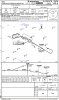
Here are two profiles for the VOR / TACAN RWY 26 into Tulsa. The top is the jepp chart, the bottom is the government issue. My point is that the 2000 shown to the right of the FAF on the government chart isn't related to the FAF, but to the inbound leg to the FAF. Same as on the original chart posted by Ron. I think it's much easier to see in the Jepp chart.
I don't think there's much confusion about the original approach.
Did you add the 2100 yourself?
Well my II is almost as wet as Chips, but seems to me the only reason as stated earlier for the FAF symbol is for timing for the missed, and after completion of the procedure turn at or above 2400, once established inbound on the radial you can desend down to 1580 ft.
I don't agree. 2,400 throughout the entire procedure turn, then 1,580 after crossing the FAF.