Droid X free EFB, maps, wx - more Android apps?

JohnSBA

Pre-takeoff checklist
Joined
Feb 24, 2010
Messages
209
Location
Santa Barbara, CA
Display Name

Display name:
JohnSBA
I got a Motorola Droid X (aka DX) smartphone (v 2.2.1) just before leaving on a long x/c flight, and have been discovering some unexpected aviation uses for it. I found that by plugging it into the aux power (adapter included with purchase at Costco) and turning on GPS, it tracks pre-viewed (cached) gMaps. Being small enough it clips nicely on my knee board, supplementing our 430 (DX has comparable screen size, but much better resolution) and Lowrance 1000 with useful information, and it's large enough to be useful at a glance. In back country, especially over snowy terrain, I liked knowing where there are roads and settlements that don't show on the charts or aviation GPS units. Over most roads and towns I was surprised to find it often even gets a 3G connection to update weather. Other than those experiments I left it in Airplane Mode, but in a pinch it could save a lot of time to browse wx online in the air without XM charges. It could even let you know in advance where to get fuel, food and other services at airports.

All this got me thinking about loading it up with other stuff, so I'm wondering if anyone else has experimented with free or inexpensive aviation apps on the Droid X. Might be able to load moving-map VFR and USGS charts on it with the free Maverick app, but I haven't tried yet.
Updates as of 3/14:
In the hope of making this thread more useful to other pilots, I'm inserting this paragraph with links to updates further down in the thread. I'll also add a few words here occasionally for asides like the fact I've tried and rejected Maverick for aviation use. My suggestion for anyone with an Android device is to download and experiment with the free RMaps and OruxMaps apps, and add your comments to this thread so we can all benefit.
Links within this POA thread:

  • RMaps initial impressions. (quick, easy, enough for some)
  • OruxMaps initial impressions. (best free av app, improving)
  • Locus initial impressions. (not for me - uninstalled)
Links outside POA:

In case anyone is choosing between the DX and iPhone as I was, my advice is go with the DX. It does everything I want that an iPhone will do plus some really important extras. For example, I ran the battery down once and swapped in my wife's (when she saw my DX at the Verizon store she just said, "I want that!" even tho I thought she'd hold out for the iPhone a friend had showed her). In less than a minute mine was running again, and I made a mental note to buy an extra battery ($15 or so I think). An iPhone in that scenario would be a brick until it was recharged. I've used Flash on a few aviation (esp. wx) websites, and of course the iPhone won't do that. Most important for me though is the larger screen, just big enough to use on the kneeboard or browse the web on the ground. In the car it has the best navigation of any GPS I've seen. I thought it would be complex or geeky compared with the iPhone, but the day I got it and before reading any directions I had it giving voice car navigation in less than a minute.

Any Droid X or other Android owners out there who'd like to share tips?
 
Last edited:
rMaps gives you geo-referenced Sectionals and other aviation maps.
 
I got a Motorola Droid X smartphone (v 2.2.1) just before leaving on a long x/c flight, and have been discovering some unexpected aviation uses for it. I found that by plugging it into the aux power and turning on GPS, it tracks pre-viewed (cached) gMaps. Being small enough it clips nicely on my knee board, supplementing our 430 (DX has comparable screen size, but much better resolution) and Lowrance 1000 with useful information, and it's large enough to provide useful info at a glance. In back country, especially over snowy terrain, I liked knowing where there are roads and settlements that don't show on the charts or aviation GPS units. Over most roads and towns I was surprised to find it often even gets a 3G connection to update weather. Other than those experiments I left it in Airplane Mode, but in a pinch it could save a lot of time to browse wx online in the air without XM charges. It could even let you know in advance where to get fuel, food and other services at airports.

All this got me thinking about loading it up with other stuff, so I'm wondering if anyone else has experimented with free or inexpensive aviation apps on the Droid X. Might be able to load moving-map VFR and USGS charts on it with the free Maverick app, but I haven't tried yet.

In case anyone is choosing between the DX and iPhone as I was, my advice is go with the DX. It does everything I want that an iPhone will do plus some really important extras. For example, I ran the battery down once and swapped in my wife's (when she saw me pick mine up at the Verizon store she just said, "I want that!" even tho I thought she'd hold out for the iPhone a friend had showed her). In less than a minute mine was running again, and I made a mental note to buy an extra battery ($15 or so I think). An iPhone in that scenario would be a brick until it was recharged. I've used Flash on a few aviation (esp. wx) websites, and of course the iPhone won't do that. Most important for me though is the larger screen, just big enough to use on the kneeboard or browse the web on the ground. In the car it has the best navigation of any GPS I've seen. I thought it would be complex or geeky compared with the iPhone, but the day I got it and before reading any directions I had it giving voice car navigation in less than a minute.

Any Droid X or other Android owners out there who'd like to share tips?

Someone will come and tell you that it was your imagination that it worked, but that someone doesn't understand the difference between CDMA and GSM.

Verizon/Sprint: Works in the air, whenever it shows signal.
AT&T/T-Mobile: Looks like it works, until you try. Receives too many towers, or some other excuse.
 
I got a Motorola Droid X smartphone (v 2.2.1) just before leaving on a long x/c flight, and have been discovering some unexpected aviation uses for it. I found that by plugging it into the aux power and turning on GPS, it tracks pre-viewed (cached) gMaps. Being small enough it clips nicely on my knee board, supplementing our 430 (DX has comparable screen size, but much better resolution) and Lowrance 1000 with useful information, and it's large enough to provide useful info at a glance. In back country, especially over snowy terrain, I liked knowing where there are roads and settlements that don't show on the charts or aviation GPS units. Over most roads and towns I was surprised to find it often even gets a 3G connection to update weather. Other than those experiments I left it in Airplane Mode, but in a pinch it could save a lot of time to browse wx online in the air without XM charges. It could even let you know in advance where to get fuel, food and other services at airports.

All this got me thinking about loading it up with other stuff, so I'm wondering if anyone else has experimented with free or inexpensive aviation apps on the Droid X. Might be able to load moving-map VFR and USGS charts on it with the free Maverick app, but I haven't tried yet.

In case anyone is choosing between the DX and iPhone as I was, my advice is go with the DX. It does everything I want that an iPhone will do plus some really important extras. For example, I ran the battery down once and swapped in my wife's (when she saw me pick mine up at the Verizon store she just said, "I want that!" even tho I thought she'd hold out for the iPhone a friend had showed her). In less than a minute mine was running again, and I made a mental note to buy an extra battery ($15 or so I think). An iPhone in that scenario would be a brick until it was recharged. I've used Flash on a few aviation (esp. wx) websites, and of course the iPhone won't do that. Most important for me though is the larger screen, just big enough to use on the kneeboard or browse the web on the ground. In the car it has the best navigation of any GPS I've seen. I thought it would be complex or geeky compared with the iPhone, but the day I got it and before reading any directions I had it giving voice car navigation in less than a minute.

Any Droid X or other Android owners out there who'd like to share tips?

Also - while it hasn't been used for a very, very long time, I was using InstaMapper on my website (http://www.meetthebrennans.com) to let family members track my wife and I as we flew places. Like FlightAware, except it wasn't willy nilly, and always worked as long as I had cell service (which, quite frankly, on Verizon, was nearly everywhere once up about 1-2 thousand feet).

InstaMapper is a free app for Android.

Also, there's a free E6B app for Android. Its not as good as Jesse's but it does the job nicely.
 
Check out Avilution. They have a moving map VFR sectional app, an AFD app, AV WX app. The moving map app will download wx from the internet and display Nexrad, Winds Aloft, and Metars on the map. The subscription fee is $4.95/mth.
 
Verizon/Sprint: Works in the air, whenever it shows signal.
Actually, my old Treo and wife's Centro didn't work in flight worth a hoot on the same Verizon numbers we have now. Even text messages often didn't go. Are you saying Android phones on V/S work better?

This Droid X gets out a text most anywhere, has cell coverage (untested for voice) where you'd expect (roads, towns, etc.), and even gets 3G over major areas. Voice quality's way better than the Palms too, speakerphone's great, and it doesn't seem to care how you hold it (unlike iPhone). As you can tell, I'm excited to actually learn how to use it now that we're home and have time, so the helpful website links already posted on this thread are much appreciated.

What I meant to say, but didn't say properly was that if you see that you have signal, it works, even in the air (although, I have found VZW's coverage between 3-5K AGL is better than most others). With GSM networks, T-Mobile and AT&T specifically, you'll see you have full coverage, but when you try to use it, it fails. Not so with CDMA.
 
InstaMapper is a free app ... Also, there's a free E6B app for Android.
Does anyone know the name of the E6B app? I'd also like to find free apps for pilot log and w/b. The google market seems like drinking from a fire hose with zillions of hits on any search I've tried and no ability to sort, so tips on using that would help too. Maybe easier to just google stuff on my laptop and then search market for specific apps? [Update: I just now discovered that putting the app name in "quotes" when googling on my laptop prevents hits on similar apps] Another approach I've considered is just getting a spreadsheet app and writing my own simple log and w/b sheets, though presumably other pilots have already written some sheets and posted them someplace?

not as good as Jesse's but it does the job nicely.
What is Jesse's? An app written by Jesse that's not (yet) available on Android? I thought maybe you were talking about RunwayFinder's author, but as I recall his name is Dave.
 
Last edited:
Does anyone know the name of the E6B app? I'd also like to find free apps for pilot log and w/b. The google market seems like drinking from a fire hose with zillions of hits on any search I've tried and no ability to sort, so tips on using that would help too. Maybe easier to just google stuff on my laptop and then search market for specific apps? Another approach I've considered is just getting a spreadsheet app and writing my own simple log and w/b sheets, though presumably other pilots have already written some sheets and posted them someplace?


What is Jesse's? An app written by Jesse that's not (yet) available on Android? I thought maybe you were talking about RunwayFinder's author, but as I recall his name is Dave.

Jesse, a member/admin here, wrote an E6B app for iOS, and its apparently amazing (I have no iPhone to test on). The Android E6B I use is called FlightTools E6B. Its free on the Market. InstaMapper is also free on the Market.
 
I've just found out about an Android app named RMaps. Judging by the first review I found and a quick look at the developer's site. For the sort of x/c VFR I often fly, it's helpful to have offline maps like Maverick but adding sectionals and TACs would be great! I've long chafed at the expensive, low-res and limited Jeppesen info on the 430. Presumably there are free online AFDs somewhere too, or I can just use my Droid's 3G to check AirNav. Interesting that the developer lives in St. Petersburg, Russia and has integrated FAA charts of U.S. airspace, proving that we're a global village.
 
Re: Droid X free EFB, maps, wx - Paranoid?

while it hasn't been used for a very, very long time, I was using InstaMapper
At first glance, I'm wondering if there's a new google app to do basically the same thing as InstaMapper. That is to let friends, family or anyone see your real-time location on a map. The reason I ask is, does anyone else worry about Permissions? If there's a google equivalent, it probably has much more invasive permissions requirements than those listed for InstaMapper. It's just that Google, Inc. already owns me since the moment I bought our beloved Droids. Let me hasten to add that the same applies to iPhones, except that it's all but impossible to find out what access Apple and the developers have to your personal data. Anyway, having already surrendered (resistance is futile) I'd like to limit the spread of my data.

Now having said all that, the only troubling permission for InstaMapper is:
"modify global system settings
Allows an application to modify the system's settings data. Malicious applications can corrupt your system's configuration."
So I'm just curious, are any other smartphone (including iPhone) owners concerned about such things?

Updates:

  • Looks like the google app I was thinking of is Latitude for gMaps. Anyone tried it out? Couldn't you just turn that on in flight, then off when you don't want stalkers tracking your movements? Sub-Update: after a quick look at Latitude, I'm thinking it will be easier to just post a quick blog update from my Droid X (such as "Arrived Spokane.")
  • I just noticed the publisher link, to get a complete list of official Android apps by the friendly stalkers at Google Inc.
 
Last edited:
I've just found out about an Android app named RMaps.
Downside is that you don't download the charts in RMaps except as needed, which means 3G running in the cockpit. Other than that it works great. But Avilution and Navzilla are probably better aviation choices.
 
bought an iPad.
I'm hoping the reduced clutter of the Droid X will outweigh the larger screen of a tablet, and so far (with the help of my portable and 430 av GPS units) it does. Hopefully the new generation of Android tablets are free of the iPad's altitude and temperature limits, so that if I do end up going for a bigger screen it will still be a droid. It's pretty convenient having my EFB in my pocket when I go into town. The DX was also very handy for street nav in the rental and crew cars.
 
you don't download the charts in RMaps
Even though I got pretty good coverage over roads on this most recent flight from Edmonton to Santa Barbara, not having at least medium-res maps pre-loaded seems like a deal breaker. Maybe I can at least figure out some way to cache the Sectionals? Looks like the Open Source application Mobile Atlas Creator might work. Probably more steps to do this on RMaps than other options, but then maybe I could also have layers of USGS and other maps?
Update 3/14: RMaps seamlessly and automatically caches every map you view, so only GPS would be required for moving-map use in the cockpit and even in Airplane Mode (all RF devices off) it works great for manually browsing maps aloft. This is apparently also true of OruxMaps, though I haven't yet confirmed it.

Avilution and Navzilla are probably better aviation choices
Thanks for mentioning Navzilla. I'm a little leery of anything that's not on the official Android Market but can see why they'd need their own site for subscriptions. For some trips it would be nice to just go, without any pre-loading. Plus, many VFR flights tend to take different routes due to whim or weather so anything that requires downloading in flight is unlikely to be useful and if it's simple and easy something like Navzilla could save the day.

Update: I'll need to check out OruxMaps too, and see what it offers.
 
Last edited:
Good on you for checking permissions. too many people don't.

Instamapper does need the permission to modify system settings because it has a button that enables/disables the gps.
 
I'm hoping the reduced clutter of the Droid X will outweigh the larger screen of a tablet, and so far (with the help of my portable and 430 av GPS units) it does. Hopefully the new generation of Android tablets are free of the iPad's altitude and temperature limits,
Temperature limits might apply in both cases to a larger display and since I hear that the iPad was tested to something like 31,000' for it's EFB certification for certain 135 and 121 ops...
 
checking permissions. too many people don't
Agreed. Inattention to that by most people puts all of us at more risk, and encourages disreputable developers to use and sell our personal data (or simply take over everyone's iPhones, tablets and other toys).

need the permission to modify system settings ... enables/disables the gps.
Much as I appreciate Android's reporting and user control of permissions, there are two improvements I'd like to see (but given aforementioned popular attitudes probably won't). First is more "granularity" so that I can allow specific access (like GPS toggle) without also allowing a developer to own my nifty Droid X. There's quite a bit of that in the "Show All" pulldown menu for all apps. Yet another thing I like about Android in this regard is the fact it's open source, and that's how the recent Market hack was discovered and led to quick action by Google in zapping the offenders.

The other improvement I'd like, is ability to toggle individual permissions, so that if I'm paranoid (already ascertained) I can sacrifice unwanted features of an app to eliminate a small risk.

Anyway, thanks again for all the tips and pointers. I'll continue to post updates and questions here, and hope others will too. This thread has already saved me countless hours of experimentation with the benefit of your experiences. I have a dozen tabs open in my laptop's browser, ready for more exploration. Right now though, outside it's severe clear with light and variable, so in celebration of our safe return from the Winter Wonderland of Edmonton we're off to fly the Spring colors of home... :D
 
hear that the iPad was tested to something like 31,000' for it's EFB certification
Even though I've decided against Apple products for this application right now (love my 2 year old Macbook!), I'm very glad this certification was done because it paves the way for others. Friendly competition is always a Good Thing in my book.

I appreciate your mention of the recent certification and the restraint you and the hordes of other happy iPad users have shown thus far. I'm hoping this thread can keep the focus on Android hardware and apps, because as we all know it's much too easy for us to slip into platform disputes that would dilute any value this thread might have for pilots seeking info in the future. If anyone would like to start a platform comparison thread, I'll happily join the fray. :)
 
I appreciate your mention of the recent certification and the restraint you and the hordes of other happy iPad users have shown thus far.
You won't find me in a platform dispute. I have a Droid and love it. My decision to go with an iPad also was based on available applications, in partucular ForeFlight, not the platform. My comments about Android apps is based on the fact that I use them.
 
Agreed. Inattention to that by most people puts all of us at more risk, and encourages disreputable developers to use and sell our personal data (or simply take over everyone's iPhones, tablets and other toys).

Much as I appreciate Android's reporting and user control of permissions, there are two improvements I'd like to see (but given aforementioned popular attitudes probably won't). First is more "granularity" so that I can allow specific access (like GPS toggle) without also allowing a developer to own my nifty Droid X. There's quite a bit of that in the "Show All" pulldown menu for all apps. Yet another thing I like about Android in this regard is the fact it's open source, and that's how the recent Market hack was discovered and led to quick action by Google in zapping the offenders.

The other improvement I'd like, is ability to toggle individual permissions, so that if I'm paranoid (already ascertained) I can sacrifice unwanted features of an app to eliminate a small risk.

Anyway, thanks again for all the tips and pointers. I'll continue to post updates and questions here, and hope others will too. This thread has already saved me countless hours of experimentation with the benefit of your experiences. I have a dozen tabs open in my laptop's browser, ready for more exploration. Right now though, outside it's severe clear with light and variable, so in celebration of our safe return from the Winter Wonderland of Edmonton we're off to fly the Spring colors of home... :D

One of the main reasons Android lacks that granularity is because it would allow people using ad-supported apps to block access to the network for downloading those ads, thus depriving the developer of the ability to recoup costs associated with the app.

But I agree, that would be a nice feature.
 
Re: Droid X free EFB, maps - OruxMaps initial review

OruxMaps Initial Quick Summary: Like most good apps on the Android platform, this app is quite good and getting better very rapidly. With a bit of learning and perhaps interaction with the apparently quite responsive developer, pilots can probably have a great free av. app while also helping to support such resources being available to other pilots. If you need an av app that's as quick and easy to use as a Lowrance 2000, this probably isn't there yet though it has many features not available on dedicated av GPS units.

If you have an Android device, Orux is well worth the quick free download and is an app to watch. Right now there seems to be a race between RMaps, Orux and Locus that benefits Android owners. If a few pilots got together behind any of these apps and maybe did a wiki documentation project, we might find we already have several free apps that meet all our needs. Right now nobody seems to be writing clear and concise documentation for any of these apps. Simple steps to set up/use one for flying would be a great asset.

Initial Impressions: I've downloaded and messed around with OruxMaps at home (stationary), and it looks like it could be a great free VFR (and possibly IFR) solution on my Droid X and other Android devices. The downside so far is the documentation. The flexible and full-featured interface is quite intuitive, and in a few minutes I had gMaps displaying in OruxMaps with some great extras beyond what I had flying with just stock gMaps. It seems pretty easy to set it up so that you can browse online maps at home (pre-fly a route), and it will automatically cache the maps so you don't need a net connection in flight.

One problem I have is figuring out how to point the online map source at something other than what's in the menu (e.g. input a source url). That problem is greatly compounded by the documentation, which is unclear and uneven. The many frequent and remarkably cool upgrades to the app haven't always been updated in the docs, English seems to be a second language for the author, and useful updates I saw mentioned on the developer site & in the blog didn't seem to be documented in the [user] manual page. I haven't yet read the downloaded PDF manuals to see if they're better or different.

I'm unable to get any online map source besides gMaps street view working in Orux other than a brief glimpse at gEarth maps. The widest sat view loaded, then I was unable to zoom in or get anything else to load. With the "VFR maps" option, nothing showed up at all and no indication of what if anything was happening. Any time I went back to gMaps it worked fine. Could be I didn't wait long enough for them to load (gave up after a minute or two). Even gMaps terrain view would be great, since it's probably a small file and quick to load/store for offline use. Best of all of course would be VFR charts, but so far not a glimpse of those.

That said, Orux is clearly designed to also use offline maps created with Mobile Atlas Creator (aka "mobac" or TrekBuddy). That would be great for a device like my Droid X or an Android tablet with lots of storage space, and for people with slow or per MB phone data. Several aviation user posts on the developer's blog seem to indicate that pilots have av charts working happily for them, including live or cached online charts that spare you the steps of using mobac. The downside of course is learning and doing the steps involved in creating and installing offline maps, but the documentation seems to be much better and the maps will work with most any av or map app, probably including those on the iPad.

In all, these are exciting times for Android devices in the aviation community. This year is likely to see exceptionally rapid development beyond the already great free resources already available. Since several apps have a spectrum of useful and needed features, the lead will probably go to the app with the most intuitive interface and best documentation.
 
Last edited:
Re: Droid X free EFB, maps- Locus initial review

Locus Initial Quick Summary: At first glance, the interface for this app is more intuitive but OruxMaps seems to have many more features that will be useful for pilots. Another big drawback for me is that the free version comes with annoying ads that take up valuable screen real estate and are easy to inadvertently touch (think turbulence) and launch Market into some uninteresting app when you're trying to use Locus. While this is a deal breaker for me, the screen shots seem to indicate the pay version does away with the ads (free OruxMaps has no ads).

On the upside, there are handy tooltips and other slick features that make for ease of use. I was also quickly able to choose between gMaps, terrain, and satellite/hybrid maps. The auto-rotate (tilt Droid to get landscape/portrait map display) is on by default, and reorienting the map to North is intuitive and quick.

I've yet to find any mention of VFR use on the rather unhelpful developer's site or the apparently more active forum. As with OruxMaps, the developer seems quite responsive. The one aviation post on the forum requests bearing-to, and it was added the next day.
 
Re: Droid X free EFB, maps- RMaps initial review

RMaps Initial Quick Summary: Clean and Simple - two words I've been looking for in my intial reactions to the main crop of free Android moving map apps. The moment I launched RMaps and it showed almost nothing but maps, I was smiling. Of course, gMaps does fairly well in that regard so two more qualities immediately came to mind: 1. How hard is it to cache maps for offline viewing in flight? 2. How hard is it to use VFR Sectionals online and offline? Other pilots will of course have other priorities and additional key criteria (as do I). But having looked at OruxMaps and Locus and been sorely disappointed on both points, RMaps instantly caught my attention. No clutter as with the very unwelcome ads on Locus, or the numerous buttons arrayed across the top of the OruxMaps display = Clean. Having my choice of street, terrain, or (drum roll...) VFR Sectionals on screen and working either online or offline without reading directions = Simple.

Some great additional features I liked immediately were (once I figured them out) being able to long-touch the enigmatic - + icons at the bottom of the screen to instantly have preset fav Min/Max zoom levels; or the ability to double-tap the screen to orient North after messing with the Compass feature (cool on the ground but of limited value in flight, imo). Additional options are accessed via the Android hardware options button (left-most).

Then things began to bog down. I have yet to figure out (still without reading the manual or checking out the developer's blog) how to quickly get distance to a point, distance units displayed in NM rather than SM, or other stuff useful for aviation like bearing to.
 
Last edited:
Re: Droid X free EFB, maps, wx - Initial Summary 3/14

At this point my preference is to continue buying current VFR Sectionals, learn my way around RMaps and OruxMaps by flying them, tinker with mobac (starting with the Taranfx quick tutorial) enjoy the incredibly fast development of these apps, and probably by summer begin phasing out paper in the cockpit. Well, maybe some mostly-current WACs will remain folded within reach. But with our 1983 172Q already sporting an original model Garmin 430, my beloved simple Lowrance 1000, and now the remarkable Droid X, paper seems so ... yesterday.

Of these three free apps (RMaps, OruxMaps, Locus), my choice is currently RMaps for quick VFR charts and OruxMaps for everything else.
TIP: Long-press the Home button on any Android device to get a display of recent apps, then choose the one you want. This makes it quick and easy to switch between these two apps. I also use it as the shortcut I've not been able to find elsewhere, to turn Data on/off without wading through the Settings menus - just turn Data on or off, then long-press to go directly between that setting and your apps.

Even using the Droid X on gMaps without cached offline maps flying low and slow along roads from Edmonton to SBA it was quite useful. Occasional glances down at my kneeboard where it was clipped provided me with extra terrain and place name info, txt messages, and ADDS weather with at least 1G data for about 80% of the locations I tried. Adding uncertified moving-map VFR Sectionals just made this little "giant screen" $150 phone [Update 4/15: just saw it on sale for $50 at Costco] a major player in the flying game.

I hope others will share their favorites, tips, and solutions for free Android aviation apps here in this thread or at least on POA. I'll probably continue posting updates here in this thread as I figure out how to use the more powerful features in these two apps, explore mobac and post a how-to, and pass along news about improvements in the apps and any new contenders I try out. If any of this has been helpful to you, questions come to mind, or you have something to add, please add to the thread.
 
Last edited:
Just had an idea. Problem: the current Market version of RMaps comes with avcharts Sectionals working (it's said to work on OruxMaps' beta from the developer's website, but doesn't work on the Market version I downloaded). Idea: I changed the Maps directory setting in OruxMaps, to see if it will use the Sectionals downloaded by RMaps (presumably to the /sdcard/rmaps directory).
OruxMaps default directory (in Settings/Application...):
/sdcard/oruxmaps/mapfiles/

Alas, it didn't work. Later I might find a way to do it, but perhaps more likely is that the two apps use different ways of storing their offline files or have different internal naming conventions for the subfolders. I tried manually copying the RMaps VFR browsing cache file to a folder named rmapsvfr in the same OruxMaps mapfiles folder as their folder named world with two files in it. I then renamed the rmaps file OruxMapsImages.db to match the main file in the world folder hoping Orux would create an xml file like the world folder has, but only "world" still shows up as an option in the Orux "Browse maps" option. Oh well... :)
 
On a members-only Cessna forum, someone mentioned AirWX that's $7 one-time app with no subscription fee for live weather, radar, plates, AFD info and other stuff. Please post if you've tried it. So far I'm resisting anything that isn't free, because so much is free with a browser that seems to work quite well aloft with the Droid X. I haven't actually tried that in flight, but it seems easy and reliable enough that my wife could look stuff up on her DX while I'm flying.
 
Last edited:
For some reason I cannot get any of the aviation maps in Rmaps to load. The other maps seem to load with no problem. When I click on any of the VFR or IFR charts my droid X stays stuck on the loading screen....
 
Also on that Cessna forum just now, someone recommended FltPlan Mobile. Anyone here have feedback on it?

Its an excellent app, but it requires data access, so it may not always work in the air. Its basically a portal to FltPlan's website (which some people don't like). I personally think that is the way to do a mobile site for aviation, since it loads only the pertinent information you need, and not the entire website.
 
On a members-only Cessna forum, someone mentioned AirWX that's $7 one-time app with no subscription fee for live weather, radar, plates, AFD info and other stuff. Please post if you've tried it. So far I'm resisting anything that isn't free, because so much is free with a browser that seems to work quite well aloft with the Droid X. I haven't actually tried that in flight, but it seems easy and reliable enough that my wife could look stuff up on her DX while I'm flying.
Got it. Use it. Love it.
 
cannot get any of the aviation maps in Rmaps to load
Maybe re-install RMaps? I think lots of av chart apps went bonkers when RunwayFinder got that bogus legal threat and had to temporarily shut down. Could also just be one of those little glitches that happen from time to time with everything. fwiw my version of RMaps is 0.8.7.3 and it works flawlessly on VFR Sectionals (the only charts I've tried). Loads them quickly, caches them automatically for offline moving map, and though I've not yet flown with it seems to work perfectly. I did get an error message once, but saw no difference or interruption in operation. I'm very interested to check out the update of OruxMaps when it comes out, because that app seems much more robust and mature.
 
basically a portal to FltPlan's website
Thanks for the feedback. I decided not to try it yet, after reading more about it. Seems like other free options (including just browsing my fav av sites with Firefox mobile) offer more powerful and extensive solutions and info. This of course betrays the fact that I very rarely file flight plans - just VFR and often flight following.

Speaking of fav websites, I love how well the CWSU interactive map worked on the DX when I tried it. I could pinch-zoom in and tap an airport's status color dot to get the handy translated METAR I get on a computer using mouseover. Though it lacks sat or radar overlay, the terrain relief is somewhat handy. Don't recall whether I tried it with Browser (I call it "Bowser" because it's a bit of a dog) or FF mobile, so there's another thing to check for my next flight. Anyway, unlike nearly all NWS/NOAA weather sites it seamlessly includes the major adjoining parts of Canada & Mexico. That's really handy for cross-border flights.
 
Got it. Use it. Love it.
Glad to get an enthusiastic endorsement of AirWX. Would you be willing to write up a summary of what you like/dislike? The reviews on Market are too short for useful feedback, and your comments would be very helpful both in deciding on apps and gaining any tips/tricks you've discovered.
 
I really haven't found a lot of tricks. The ability to do a quick check of weather using either it's GPS location for "nearest" airports or to check destination and en-route conditions shortly before takeoff (even to the extent of anticipating which approach will be used) without having to surf around to different sites or key in identifiers is worth the one-time price. With 3G is also works en route.

One of the things I like best, though, is the option to call AWOS directly from the app. It's a menu item and connects directly to the phone.
 
quick check of weather using either it's GPS location for "nearest" airports or to check destination and en-route conditions
That's pretty cool, and certainly a time saving feature. I'm imagining a quick fuel stop, and pausing to update weather. Shaving 5-10 minutes off that puts us that many miles closer to our destination.

anticipating which approach will be used
Remarkable! Thanks for mentioning it.

option to call AWOS directly from the app
Very nice! Little stuff like that really adds up to a lot of ease. Thanks again for sharing. If you think of anything else, please add.
 
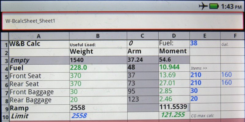
I've been working on a W/B spreadsheet (see this POA post) for my 172Q that calculates CG, useful load and gross weight from my loading inputs. So far I'm using the free Shead Spreet Lite as my app for this, but will also be investigating other options. Here's how the current version of the sheet looks on my DX:
w-bcalccapture.jpg


I haven't yet figured out the font and background color scheme used by Shead Spreet (it doesn't seem to completely follow the ones in the excel-format sheet I created with Open Office). I'd like to have different colors for the main input points (passengers & baggage), and maybe key outputs like useful load and CG Arm (not yet added to the bottom of that column).

Among the things I dislike about Shead Spreet is the scary Permissions related to its use for barcodes and inventory. I wish the developer would stop resisting the fervent input from his users and just release a bare Permissions sub-version.

Anyway, it's going to be great having a free W/B tool in my pocket on the ramp. Along with all the other cool stuff smartphones can do for pilots these days. :)
 
Last night (at home) I messed around with the new version of the free Google Earth app for Android on my Droid X, and it got me curious if there's a way to find out what the cache limit is and whether there's some way to change it. I found a page with google directions but of course it's just a basic user manual. Last night I "flew" gEarth on my phone around SBA at about 3k'AGL and then up Hwy.101 at about 20k'AGL and "descended" back to cruise Saratoga at 3k and zoomed down to 200' or so over my sisters' homes. All that stayed in the cache and was there to re-fly offline, so it would be useful even in Airplane Mode if we didn't use 3G aloft. Despite some googling, I haven't yet found anything about the cache limit or settings. Would also be nice if like the desktop version it would show altitude and terrain height. Anyone know more?

Meanwhile, it was so scary cool having simulated vision on my phone we're excited for my wife to try it in flight. I guess most (all?) Androids have a built-in compass/gyro, so presumably this will work on any of them. Basically, it's like their fun free Sky Map for stargazing. You point the phone at something (hold the phone between you and target), and see the virtual view with descriptive info. So with her phone attached to the panel or yoke at the correct angle, it would show in real time a satellite/map hybrid moving view of what's ahead. Pick the phone up and point it at something out the side window, and she gets details on that. Kinda mind boggling.
 
Back
Top