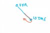
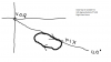
Can someone tell me what kind of holding instructions ATC might use for this kind of hold in the picture?
Would it be something like this? "Allegiant 640 hold northwest of the Grand Forks 120 radial, 10DME"?
Is this a common type of hold to receive from ATC?
First problem is that you cannot hold northwest on the 120 radial because it extends southeast of the Gran Forks VORTAC. "Radial means from." right? You illustrated it correctly but said it wrong.
From the 7110.65:
-"6-4. HOLDING INSTRUCTIONS When issuing holding instructions, specify:
a. Direction of holding from the fix/waypoint.
b. Holding fix or waypoint.
NOTE-
The holding fix may be omitted if included at the beginning of the transmission as the clearance limit.
c. Radial, course, bearing, track, azimuth, airway, or route on which the aircraft is to hold.
d.
Leg length in miles if DME or RNAV is to be used. Specify leg length in minutes if the pilot requests it or you consider it necessary.
e. Direction of holding pattern turns only if left turns are to be made, the pilot requests it, or you consider it necessary.
PHRASEOLOGY-
HOLD (direction) OF (fix/waypoint) ON (specified radial, course, bearing, track, airway, azimuth(s), or route.)
If leg length is specified,
(number of minutes/miles) MINUTE/MILE LEG.
If direction of turn is specified,
LEFT/RIGHT TURNS."
So it would be "Hold southeast of the Grand Forks Vortac on the 120 radial, ten mile legs."
Bob Gardner


")