GreatLakesFlying
Pre-takeoff checklist
Hi everyone.
I am looking at a flight from Grand Junction, CO (KGJT) to Sidney, NE (KSNY), in an Arrow III (normally aspirated engine). Any direct route will require that we overfly some serious elevations and I'd rather avoid that. The alternative is to take I70 eastbound to Rifle, thence north to Meeker and further up until intercepting I-80, round Medicine Bow, and off to the plaines. The terrain under this route is between 6500 and 7500. This leaves me room to fly at 9500 comfortably and minimize (if not eliminate) the need for O2 -- we'll have it on board in case, though.
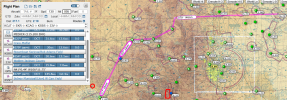
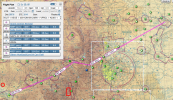
The route I've worked out on Foreflight is below. (For locals, this follows I70 e/b, CO 13 n/b, then Moffat county road 7 n/b, and Moffat county road 57 n/b).
It will be VFR/FF until we'll clear the Rockies. I'd welcome suggestions, cautions, and other advise. Thanks in advance.
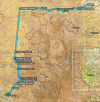
(Map added at @ArrowFlyer86 suggestion).
KGJT 39.11195/-108.33206 SQUAT 39.46906/-108.02444 39.57659/-107.8133 39.65302/-107.88059 39.70507/-107.93758 39.95291/-107.96814 40.14214/-107.96883 40.2224/-108.05603 40.27723/-108.09714 40.30689/-108.12075 40.319484/-108.126316 40.51693/-108.08556 41.92885/-107.88849 FIKLA 41.8552422/-106.6209412 41.9043212/-106.4369202 41.9094315/-106.2982178 MBW 41.9406/-105.56385 41.92323/-105.38086 KEAN KSNY
I am looking at a flight from Grand Junction, CO (KGJT) to Sidney, NE (KSNY), in an Arrow III (normally aspirated engine). Any direct route will require that we overfly some serious elevations and I'd rather avoid that. The alternative is to take I70 eastbound to Rifle, thence north to Meeker and further up until intercepting I-80, round Medicine Bow, and off to the plaines. The terrain under this route is between 6500 and 7500. This leaves me room to fly at 9500 comfortably and minimize (if not eliminate) the need for O2 -- we'll have it on board in case, though.
The route I've worked out on Foreflight is below. (For locals, this follows I70 e/b, CO 13 n/b, then Moffat county road 7 n/b, and Moffat county road 57 n/b).
It will be VFR/FF until we'll clear the Rockies. I'd welcome suggestions, cautions, and other advise. Thanks in advance.
(Map added at @ArrowFlyer86 suggestion).
KGJT 39.11195/-108.33206 SQUAT 39.46906/-108.02444 39.57659/-107.8133 39.65302/-107.88059 39.70507/-107.93758 39.95291/-107.96814 40.14214/-107.96883 40.2224/-108.05603 40.27723/-108.09714 40.30689/-108.12075 40.319484/-108.126316 40.51693/-108.08556 41.92885/-107.88849 FIKLA 41.8552422/-106.6209412 41.9043212/-106.4369202 41.9094315/-106.2982178 MBW 41.9406/-105.56385 41.92323/-105.38086 KEAN KSNY
Last edited: