Colorado Springs

Nope. Advice remains the same. Stay out of passes and you’ll be just as safe as you are at home without new knowledge requirements. Flying over mountains the same.

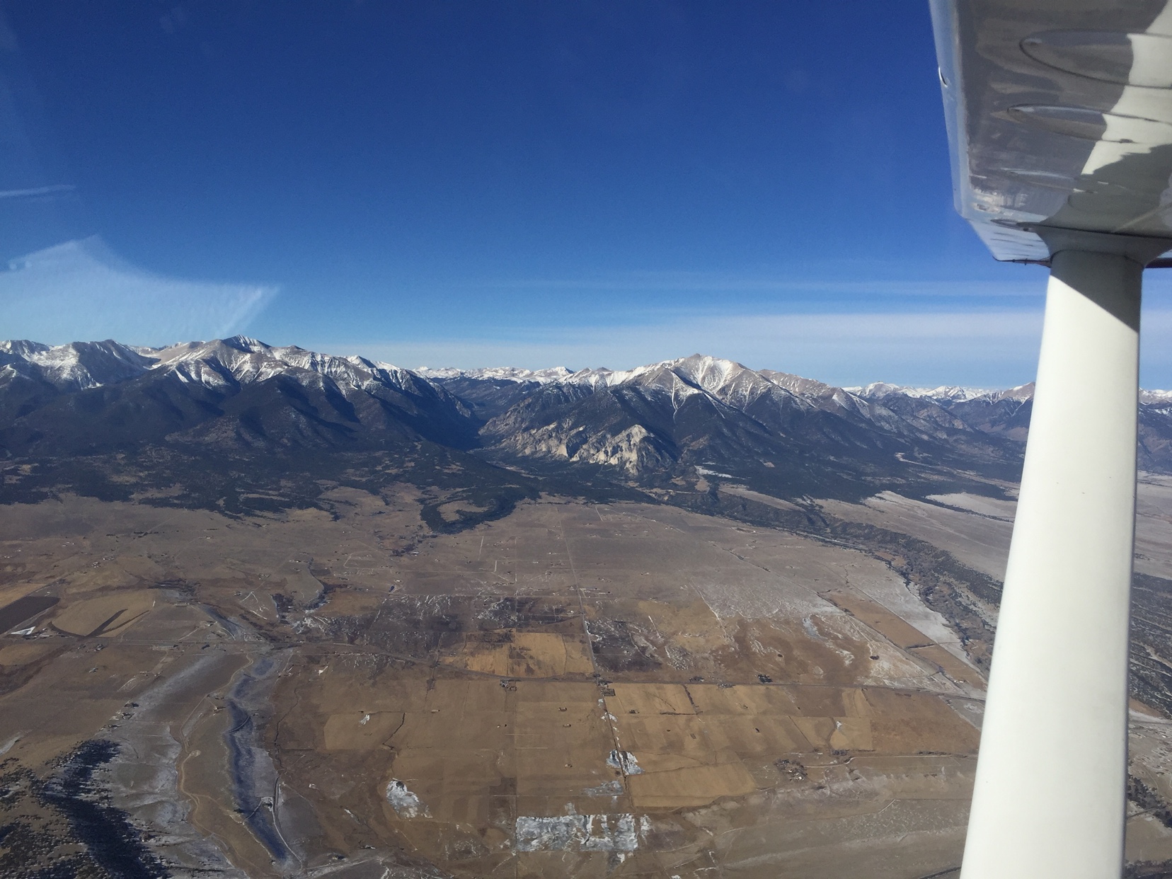
I agree with Nick that staying out of passes is a real good idea. One of my methods is to fly over a pass rather than through it as long as the ceiling allows it of course. This method gives maximum terrain clearance at a given altitude for the area and avoids the possible higher winds funneling through the pass. The turbocharger helps the 'kota have the performance to use the method. Lots of folks don't have the performance and get stuck with long shuttle climbs or just accept less terrain clearance. A couple people from POA have ridden with me in the hills and have seen that I take the extra time required to climb for terrain clearance well before the pass.

There is a particular weather phenomena which has nothing to do with passes but is a concern when flying in the general vicinity of mountains: rotors and mountain turbulence. It's a very real problem particularly in the winter when high winds drop down from the upper atmosphere. We've seen hundred mile an hour winds on mountain AWOSs so ya gotta be a little careful with being downwind of peaks. In some conditions you'll see the clouds streaming off the peaks and it's easy to tell that ya don wanna be goin' there. Other times when it is particularly dry the disturbed air won't have telltale clouds. A wise mountain pilot is aware of the direction and velocity of winds aloft and avoids the disturbed air downwind of peaks when velocities exceed 20-25 knots. Sometimes ya get caught in higher winds. One out can be to climb, climb, climb. Another out can be to get really low so the mountains actually block the wind for you. Beware that rotors can have enough energy to hit the ground in some places and there is no wind block.

If you're going to be flying over or around the mountains out west then Sparky's book is a good resource for background material.
 
She can.

Me? I just cover up the panel, set power and hope for the best...
I had a hard time locating the appropriate needles on your panel, especially from the right, so I reverted to looking out the window, at the horizon. That technique actually works! Or I was lucky.
 
I had a hard time locating the appropriate needles on your panel, especially from the right, so I reverted to looking out the window, at the horizon. That technique actually works! Or I was lucky.
Ha, we all know that you have internal static instruments.
 
For the doubters, here is a link to the math:
http://www.nar-associates.com/technical-flying/altitude/part1/altitude_part1_wide_screen.pdf

Look at the final two paragraphs on page 2. :D

Now, from a practical perspective flying out of 5K long runways at only 5K MSL, will it matter. Probably not. But if you ever want to learn to fly and get the majority of the use out of your plane, you really should understand this stuff. It is helpful to know how this affects not only stopping distance, but takeoff, climb performance, reaction performance...
I have run the numbers when flying an SR20 out of 2K runways needing to clear trees in summer; at sea level and at airports a paltry 3K MSL. And I could see a difference.

Tim

Never really looked hard at the numbers for power required vs altitude in airplanes. In can tell you the power required for a given indicated airspeed does go up in helicopters with DA. The loss of rotor efficiency with increase in altitude will necessitate a higher power (torque) requirement. A few % in trq isn't much but an increase none the less.

Of course, indicated stall speed remains the same with increasing altitude...or maybe not (second para). ;)

https://www.flightsafety.org/ap/ap_sep91.pdf
 
Last edited:
Never really looked hard at the numbers for power required vs altitude in airplanes. In can tell you the power required for a given indicated airspeed does go up in helicopters with DA. The loss of rotor efficiency with increase in altitude will necessitate a higher power (torque) requirement. A few % in trq isn't much but an increase non the less.

Of course, indicated stall speed remains the same with increasing altitude...or maybe not (second para). ;)

https://www.flightsafety.org/ap/ap_sep91.pdf
That guy is definitely confusing indicated with true since he is referencing Reynolds number. Reynolds depends on the actual fluid velocity.
 
That guy is definitely confusing indicated with true since he is referencing Reynolds number. Reynolds depends on the actual fluid velocity.

There are a few others support with the Reynolds number theory. I've read the UNTPS article before it was removed from the thread and they supported that an increase in altitude will produce a slight increase in indicated stall speed. All due to a decrease in Reynolds number.

https://www.airlinepilotforums.com/technical/22778-indicated-stall-speed.html

I go with the basic FAA guidance:

j. Altitude and Temperature. Altitude has little or no effect on an airplane’s indicated stall speed. Thinner air at higher altitudes will result in decreased aircraft performance and a higher true airspeed for a given indicated airspeed. Higher than standard temperatures will also contribute to increased true airspeed for a given indicated airspeed. However, the higher true airspeed has no effect on indicated approach or stall speeds. The manufacturer’s recommended indicated airspeeds should therefore be maintained during the landing approach, regardless of the elevation or the density altitude at the airport of landing.
 
Last edited:
There are a few others support with the Reynolds number theory. I've read the UNTPS article before it was removed from the thread and they supported that an increase in altitude will produce a slight increase in indicated stall speed. All due to a decrease in Reynolds number.

https://www.airlinepilotforums.com/technical/22778-indicated-stall-speed.html

I go with the basic FAA guidance:

j. Altitude and Temperature. Altitude has little or no effect on an airplane’s indicated stall speed. Thinner air at higher altitudes will result in decreased aircraft performance and a higher true airspeed for a given indicated airspeed. Higher than standard temperatures will also contribute to increased true airspeed for a given indicated airspeed. However, the higher true airspeed has no effect on indicated approach or stall speeds. The manufacturer’s recommended indicated airspeeds should therefore be maintained during the landing approach, regardless of the elevation or the density altitude at the airport of landing.
Well I made it to the third page of that thread before I got disgusted with people confusing the various airspeed terms and making up things. It’s funny how the loudest voice (2 kts/5,000 ft increase in CAS) is the easiest to debunk. No way in hell is stall speed 4 kts faster at 10,000 feet or many of us would have had trouble landing at Leadville.

I don’t doubt that things get interesting as Mach number increases. I don’t doubt that things get interesting as Reynolds numbers change significantly. For us spam can drivers not much is changing.
 
Cool.

I’m going to go give myself a hernia loading the 3000W generator into the car and taking it to the hangar because the 1000W struggles sometimes with our preheater. One less thing to worry about on Monday. Going to be cold. You people with electricity in your hangars make me jealous. LOL.

Go fly the plane around the patch and make sure the battery is behaving and charged up, too.

And take gas for the tug out there, it’s low.

And diesel for the big hangar heater.

And air compressor for the tires on the heater. And probably check the airplane and the tug too...

And... well whatever.

Winter. Bleh. I ain’t a badass hand propping a cub in snow like @Shepherd that’s for sure. But I might. If I had a Cub. LOL.

If I leave the 3000W at the hangar and we have a power outage at home, Karen will be motivated to let me buy that whole house genset and have it installed, too... LOL.
Altho I have electricity at the hangar, there's no heat. But I put an engine block heater on the engine which I can turn on from home thru the cell phone link, the tug has a rechargeable battery, long extension cord for the air compressor, and the microwave is just fine for making hot chocolate or perhaps microwave lunch.

[ snarky comment off ]
 
Great fun. I'll check tire pressure tomorrow and plug in the crankcase heater. The charger/maintainer is always on. Might kick it up to high voltage setting. Won't bother with fuel until Monday morning. Oh, and my "tug" always has gas...
Still not cold enough for the BBQ
 
Thursday’s going to get down there and try... 21 day / 01 overnight... :)
Sounds like the perfect day for the BBQ at Clark's hangar. Shall we start the menu for a potluck? Might be a great time for a PoA meet.
 
Sounds like the perfect day for the BBQ at Clark's hangar. Shall we start the menu for a potluck? Might be a great time for a PoA meet.

I’m stuck in the office all week, unfortunately. We let the junior sysadmin out of his cage and he bolted until after New Years. Bwahaha.

I’m still kinda “part-time...ish” at the office but this week I’m the “cover the afternoons and evenings so the users don’t get too cranky while the junior sysadmin/desktop support guy is out”, guy.

This is also in prep for disappearing for a number of weeks in January to finish ratings, so it’s a trade off. He’s out now, I’ll stick him with all the support fun in January.

There are certain people in our user base who like to panic if they don’t physically see any IT people in our work area, and apparently don’t know how to pick up a phone, or text, or Slack... and then complain to management...

So we publish all of our well published numbers again... and point out we all have certain Slack channels set to notify us even after hours... and that we all have dual desk phone and cell phone ringing set up and have it on all the time... and we all check our email nearly constantly... and the company has GSuite so everyone can use Google Hangouts at any time for any reason... and we all have desktop remote access software so we can help anyone remotely at any time looking at exactly what they’re seeing... and...

You can make stuff that easy (my original on-call roles were with a freaking pager and that worked... I think I can handle responding to any of these newer things... no problem...) and people will still think “nobody’s here, I can’t get help!”... LOL
 
Typical thread for POA. You guys might have more friends if you learned the KISS principle. Anywhooo...for the OP

1) As mentioned there is no issue flying up and down the east side of the mountains.
2) I would not recommend flying over the range to the west. And that advice is from fellow POAers from when I flew Salt Lake to Denver. I received some great advice on route planning and made it safely. And they do care...some were messaging me to make sure I was okay. It was an anniversary trip with my wife so I wasn't really online lol.
3) If you haven't had mountain training Denver is a great place to get it. Ask for recommendations and book a flight with a cfi. I got some specific mountain flying and short field training on the west side (Rifle). That was a separate solo ski trip where I flew from Salt Lake to Rifle and parked the plane for a ski trip with friends. I received quality POA advice on that trip as well. My original idea was to fly into Glenwood Springs, and POA advice was to NOT do that without a cfi as a first time adventure. Great advice! Smallest field I have ever landed to date, with a cfi along for the ride.
4) Any plans for Denver while you are there? Three things we did: Catch an Avs game, drive a rental car over to Breckenridge and check out the ice sculpture contest (end of january), and Denver has a really cool botanical garden that's worth the admission.
 
Wow, I left for a couple days and this thread really evolved (or should I say deteriorated)! So, back to my original question...I think it’s pretty clear that I won’t be exploring any of the passes or trying to overfly a ski resort on this trip. I have absolutely no desire to put myself in a position that’s even close to not being comfortable. However, I do like the idea of skirting along the east side for a nice view. I’ll file IFR on my way in, so the scenic ride will most likely be a separate Fri or Sat afternoon flight.

Assuming the winds are less than 20 kts, it looks like going straight south out of KCOS, past the restricted airspace, and then heading west at Pueblo could be a nice option where it’s at least 6-8 miles wide between any big terrain. Any thoughts on following the highway west to Poncha Springs and then up to Buena Vista?
 
I’ll be making a weekend trip to Colorado Springs in my Warrior this January. I’ll be coming from the Dakotas and don’t have any mountain flying experience, so the plan was to grab a car and drive into the mountains for a little sight seeing on Saturday. However, after thinking about it more I started wondering if it would be doable to safely make our way west of Colorado Springs for a scenic flight this time of the year. It will only be a friend and me, so we can keep the plane light and I would only go if weather was not an issue. I definitely don’t want to get in any canyons or too close to terrain, but if we could get relatively close to one of the ski resorts or something else scenic it sure would beat being in a car. Does anyone have any recommendations?
Its completely doable! I'm laughing at some of these comments. You can still have fun and be safe at the same time. I literally just flew home yesterday from Granby, CO to Kansas City. I did some snowboarding at Winter Park and Mary Jane. We had a choice of taking my Comanche 250 or My buddy's Mooney M20C. We took the Mooney because we wanted to see how 180HP worked at 8200ft airport elevation. Density ALT was right at 8200ft and we were at 90% gross weight. I don't have formal mountain training but I certainly do my homework. My hard, fast rules are easy.... NO IMC at all, winds below 15kts, be as light as possible (90% gross or less), and do takeoff performance/rate of climb calculations. Use the 50/70 rule. If you are not at 70% of your rotation speed by 50% of runway used, abort the takeoff. Oh, and have fun!
 
Its completely doable! I'm laughing at some of these comments. You can still have fun and be safe at the same time. I literally just flew home yesterday from Granby, CO to Kansas City. I did some snowboarding at Winter Park and Mary Jane. We had a choice of taking my Comanche 250 or My buddy's Mooney M20C. We took the Mooney because we wanted to see how 180HP worked at 8200ft airport elevation. Density ALT was right at 8200ft and we were at 90% gross weight. I don't have formal mountain training but I certainly do my homework. My hard, fast rules are easy.... NO IMC at all, winds below 15kts, be as light as possible (90% gross or less), and do takeoff performance/rate of climb calculations. Use the 50/70 rule. If you are not at 70% of your rotation speed by 50% of runway used, abort the takeoff. Oh, and have fun!
Sat, Dec 16 was an absolutely perfect day for that trip, assuming GNB north to the state line then east. Even I would have headed to leadville over wilkerson pass. But today? Staying home, prepping for next semester. High winds, IMC, temps below freezing even on the plains. I fly a 180 hp,cherokee and routinely take it to 14k DA. 8200 out here is DA in the summer on the ground on the east plains.

West out of PUB takes you right over Canon City (18v) - wave to the guys at SuperMax ( no, there's no notam or anything) but be aware of heavy traffic - the USAF uses it for academy and IPT training, and IPT is based at KPUB. Just pass 18v you'll fly over the Royal Gorge. The route to Salida's not bad, then head north and stop at Leadville and get your certificate. Poncha Pass is subject to some very wicked winds at times while coming direct fromPUB is a bit easier.

Coming back, backtrack fromLeadville to Buena Vista then head east towards Wilkerson Pass, easy to do at 11.5 which takes you over South Park (yup, it really exists, and the guys are from there) then north to avoid the Academy, over the cliff and it's an immediate 1000 agl to 5000 agl which freaks people out and right turn into COS.
Not quite sure I want to venture as far north as Leadville in my underpowered Warrior, but that looks like it would be a sweet place to go! What’s the “certificate” you mentioned?
 
Not quite sure I want to venture as far north as Leadville in my underpowered Warrior, but that looks like it would be a sweet place to go! What’s the “certificate” you mentioned?

Certificate for landing at the highest public use airport in the United States.
 
Not quite sure I want to venture as far north as Leadville in my underpowered Warrior, but that looks like it would be a sweet place to go! What’s the “certificate” you mentioned?
If you're expecting to go over Poncha Pass, Leadville aint no big deal. PP is over 9K, so you'd want to be at 10 or 11K.

Consider your route PUB west to the valley, you'll still need to get to at least 11K. In the winter, shouldn't be a problem for the warrior. For someone not familiar with the area, that's another discussion.
 
Got to fly with @Clark1961 in the mountains today. I joked with him that he needed to fly his approach at Spanish Peaks two knots faster. :)

Seriously though, today was as flat calm as it ever gets up there, every valley filled with haze from inversions for 200 miles. Winds at Wilkerson Pass AWOS station were still 8 G 16, and...

The only place we got mildly rocked was, you guessed it, La Veta Pass. Right downwind of the mountain. As always.

Clark had already slowed to Va before even going in there, and we both remarked, “If we get anything, it’ll be right up... there...” He also circled over Trinchera Ranch. That’s an interesting airport. Private 5000’ asphalt. Someone’s got some pesos...

And it was where we got rocked a bit. Freaking La Veta. Always.

No bumps at 12,500 in my airplane earlier though doing the north route over Buena Vista, and Poncha Pass.

Spanish Peaks was literally the only airport for 200 miles with any wind, too. But cheap gas! 100LL was 3.90 and Jet A was 2.80 at their self serve.

We chuckled at the “Beware” sign with a picture of snakes on it. We didn’t see any but we were guessing they like to sun on the asphalt when cold and hide under the shade of the fuel pumps when hot.

Poor Clark. The 10 knot headwinds followed him around all day. LOL. Didn’t matter which direction he flew. :)

4d3c51e774522876bb1df1aa6f74a397.jpg
 
P.S. I want an Autopilot. Hahaha. Dang it.

Clark’s over there having our back seater pour him coffee after we were back out over PUB in the smooth air and he hasn’t touched the yoke for 15 minutes.

C’mon Garmin with a good retrofit for the 182...
 
Got to fly with @Clark1961 in the mountains today. I joked with him that he needed to fly his approach at Spanish Peaks two knots faster. :)

Seriously though, today was as flat calm as it ever gets up there, every valley filled with haze from inversions for 200 miles. Winds at Wilkerson Pass AWOS station were still 8 G 16, and...

The only place we got mildly rocked was, you guessed it, La Veta Pass. Right downwind of the mountain. As always.

Clark had already slowed to Va before even going in there, and we both remarked, “If we get anything, it’ll be right up... there...” He also circled over Trinchera Ranch. That’s an interesting airport. Private 5000’ asphalt. Someone’s got some pesos...

And it was where we got rocked a bit. Freaking La Veta. Always.

No bumps at 12,500 in my airplane earlier though doing the north route over Buena Vista, and Poncha Pass.

Spanish Peaks was literally the only airport for 200 miles with any wind, too. But cheap gas! 100LL was 3.90 and Jet A was 2.80 at their self serve.

We chuckled at the “Beware” sign with a picture of snakes on it. We didn’t see any but we were guessing they like to sun on the asphalt when cold and hide under the shade of the fuel pumps when hot.

Poor Clark. The 10 knot headwinds followed him around all day. LOL. Didn’t matter which direction he flew. :)

4d3c51e774522876bb1df1aa6f74a397.jpg
You go flying and don't invite me? Your 182 or the turbodakota? Dropping off thr 182 with Mark?

bah humbug.
 
Ditto Murphy above! Gee, thanks! Doesn't matter that I couldn't have joined you anyway. Work is trying to kill me, and I think they're getting close to figuring out how...
 
Got to fly with @Clark1961 in the mountains today. I joked with him that he needed to fly his approach at Spanish Peaks two knots faster. :)

Seriously though, today was as flat calm as it ever gets up there, every valley filled with haze from inversions for 200 miles. Winds at Wilkerson Pass AWOS station were still 8 G 16, and...

The only place we got mildly rocked was, you guessed it, La Veta Pass. Right downwind of the mountain. As always.

Clark had already slowed to Va before even going in there, and we both remarked, “If we get anything, it’ll be right up... there...” He also circled over Trinchera Ranch. That’s an interesting airport. Private 5000’ asphalt. Someone’s got some pesos...

And it was where we got rocked a bit. Freaking La Veta. Always.

No bumps at 12,500 in my airplane earlier though doing the north route over Buena Vista, and Poncha Pass.

Spanish Peaks was literally the only airport for 200 miles with any wind, too. But cheap gas! 100LL was 3.90 and Jet A was 2.80 at their self serve.

We chuckled at the “Beware” sign with a picture of snakes on it. We didn’t see any but we were guessing they like to sun on the asphalt when cold and hide under the shade of the fuel pumps when hot.

Poor Clark. The 10 knot headwinds followed him around all day. LOL. Didn’t matter which direction he flew. :)

4d3c51e774522876bb1df1aa6f74a397.jpg
Wow, views like that are exactly what I’m looking forward to in a few weeks. Fingers crossed that Mother Nature cooperates!
 
So, if weather cooperates and I can go south to Pueblo and then northwest to Salida and possibly beyond, is flight following even an option? If not all the way out there, are they happy to provide FF near the restricted airspace and MOA’s?
 
You go flying and don't invite me? Your 182 or the turbodakota? Dropping off thr 182 with Mark?

bah humbug.

Ditto Murphy above! Gee, thanks! Doesn't matter that I couldn't have joined you anyway. Work is trying to kill me, and I think they're getting close to figuring out how...

We be snobs. Or I can’t keep up with the Bo or they wouldn’t loan us the crew car or something...
 
So, if weather cooperates and I can go south to Pueblo and then northwest to Salida and possibly beyond, is flight following even an option? If not all the way out there, are they happy to provide FF near the restricted airspace and MOA’s?
You can get FF east of the Front Range and they really do want to be talking to you. Lots of training activity from Fort Collins down to Pueblo. Civilian up north and Air Force and Air Force contract from the Academy to Pueblo. Anyway ATC wants to know your intentions to help keep things safe. Just tell’em what you want to do and they’ll let you know about any problems they may have. Once ya get in the mountains they lose you pretty quick. Look at the MEAs along routes you are pondering and understand that you probably can’t get FF below the MEA.
 
You go flying and don't invite me? Your 182 or the turbodakota? Dropping off thr 182 with Mark?

bah humbug.

Ditto Murphy above! Gee, thanks! Doesn't matter that I couldn't have joined you anyway. Work is trying to kill me, and I think they're getting close to figuring out how...

Sorry. We weren’t even sure it’d happen on Monday until about Friday... coordinating four people n’ stuff... watching weather... yadda yadda... mumble...

Work for me all week now, too. I’m supposed to be covering for the guy who’s off and out of town but they appear to have survived today...
 
Delayed posting this minor story but it might be worth a few minutes. I’ll make it as short as I can.

Dropped Nate, et.al., at APA then had short hop to FTG. Departed east off of 10. APA Tower is talking to a guy who claims he is south of the airport. Tower sees an ident northeast of the field. That gets my attention since I intend to turn north in a minute or two. Tower has guy ident again and tower says he is northeast of the field. I decided to delay my turn north for a bit. Guy still insists he is south of the field. Tower gives him beacon code.....then tells the guy he is northeast of field. The guy accepted tower’s instruction to turn southwest towards the field but never admitted that he was lost. I finally turned north when due south of FTG...
How does he screw that one up? KAPA is at the southern edge of the Denver metro. Lol. Is the city to the north of you? Then you’re South.

Idiot.
 
The guy had to be seeing Buckley and thinking it was APA. Not that they look anything alike. Guessing he hadn’t flown to the Denver area before. Anyway he was the flying definition of navigation hazard...
 
@Clark1961 also got the fun of exiting 17L at Alpha 8 arriving at APA and then getting stepped on three times by aircraft who weren’t listening on their initial call up to ground. Haha. We just sat there stuck waiting to cross alpha to the ramp for quite a while. Ground finally just says “aircraft at Alpha 8...” trying to get us across and out of the way... LOL.

Nice weather in the middle of winter, Monday afternoon, lots of students, APA becomes a nuthouse. Totally normal. ;)
Why I love Front Range....
 
Back
Top