Colorado Mountain Routes

petrolero

Pattern Altitude
Joined
May 1, 2014
Messages
2,399
Location
Denver, CO
Display Name

Display name:
petrolero
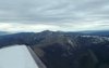
I have a TR182 and it rocks balls for mountain flying. I could climb high and ignore the rocks below but I'm trying to practice flying *in* the mountains and not just sky over them as if they weren't there. I'm still going to use the advantages of the turbo in spots but I intend to fly via passes.

Caveat: I have had mountain training and experience before (Colo. Pilots Assoc. & with Civil Air Patrol), but I like to keep training. I am familiar with, and have recently reviewed, my notes from the CPA mountain class. I mention that so that we don't rehash all the mountain rules of thumb and recommended practices.

All that to ask this...

What route would you take from:

A) Centennial Airport (KAPA) to Salida (KANK) to Leadville (KLXV) to Granby (KGNB) and back to KAPA?

B.) also, from KAPA to Gunnison/Crested Butte (KGUC)?

_____________

A) My plan is


  • KAPA,
  • Wilkerson Pass,
  • Trout Creek Pass,
  • down the Arkansas River to KANK.
  • Then back up the Valley to KLXV. I've done most of this route before (in a truly gutless C172RG), including landing & departing KLXV & KAEJ.

But Leadville to Granby presents some interesting options that I want to think through:

From most to least direct from Leadville to Granby:


  • FREMONT PASS to Dillon Res: Basically following CO 91 NE north out of Leadville (after gaining sufficient altitude, of course). That is a somewhat narrow pass that is 5 miles peak to peak. But is pretty flat on top with places to land...


  • MOSQUITO PASS to Hoosier to Dillon Res: This bad boy is barely a pass in my view at over 13,000 feet. It's basically crossing a 13,000 ft mountain range. Yes, I could do it in a turbo but meh. No good places to land....


  • WESTON PASS to HOOSIER PASS to Dillon Res: Even narrower than Fremont at only 2 miles peak to peak. I know a lot of guys like sneaking through this one. It's high and flat on top and beautiful but I don't see it as any better or worse than Fremont Pass, and it's less direct....

... Thence... Dillon Reservoir, up the Blue River Valley, cross over the Williams Fork Mountains at the saddle north of Ute Peak (NE of DOBEE int) and down into Granby.

OR


  • Leadville to TENNESSEE PASS to the long way around up by Eagle then Kremmling then Granby. This seems like a punt as it's way too far around. If I didn't have the performance to go elsewhere, this would be a good option.

Thence... From Granby via the usual ROLLINS PASS and back to KAPA.

B.) from KAPA to KGUC, a route I have never flown except for the first two passes...


  • Wilkerson Pass
  • Trout Creek Pass
  • Poncha Pass
  • Marshall Pass (CPA advises against Monarch - too long and tortuous)
  • Down into KGUC

Anyone have experience with some of these passes? Obviously winds at 12k and other general weather will have to be favorable. Winds aloft are pretty dead this time of year but we'll see.
 
Last edited:
Have you started with the CPA's Commonly Flown Mountain Passes and the state VFR chart - the one from the Colorado Aeronautics Division? It actually highlights commonly flown mountain passes.

The caveat to many of the passes is wind and weather and the venturi effect you learned about in the CPA course - that's part of the issue with the narrower ones you mention. Monarch, on a calm day is actually quite pleasant and beautiful. I'be flow it a number of times. But it's because of what the winds do there, combined with the pass altitude, that we tend to avoid it if the weather is not perfect. Marshall is a bit easier to negotiate lower down.

I've flown all the passes you mention other than Tennessee, Fremont, Hoosier, Weston and Mosquito.

Typical KAPA-KGUC route for me (including my last mountain flight about a month before I moved away) was Wilkerson - Trout Creek and either Monarch or Poncha/Marshall depending on the weather.

Thanks - that's a good resource. It doesn't list any of Fremont, Mosquito (not commonly used), or Weston though. CPA basically uses Hagerman or Tennessee passes to get into/exit the Arkansas River valley in its training routes.

I took notes on Weston pass in the class. They said it was narrow and only recommended in light winds but was relatively flat on top with places to land. In the right conditions, they said it's a decent alternative to going down around the corner to get to Leadville.

I'm leaning toward Fremont Pass if winds are decent.
 
Just a couple comments.

Mosquito Pass is so narrow that a suitable landing area isn't a question, if yer high enough to get over it then you'll be able to glide to a flatter area. That said, the ups-and-down drafts can be "interesting" with that much elevation change in a very short horizon

ANK to GUC, just circle northwest of ANK until you have your desired clearing altitude. Follow the road toward Monarch until it starts it's big left turn through the actual pass, you go just about straight west (a little bit south of west actually) and head down the slope. Don't follow that damned road. The important part is to get your clearing altitude before ever heading up the valley towards the pass.

Clearing altitude before heading for the pass is a major rule for me. Much better to circle and sightsee rather than pucker while looking at rocks getting closer.

And if you don't like Monarch because of all the aluminum bits scattered around, then yes, Marshall or even the long way around to North are better routes. Don't do this on a hot day...it's tough enough in the cool of morning. But then your 182 should do a bit better than my 'kota.
 
I'm in Granby now at my vacation home- one of my main reasons for learning to fly is to get here quicker. Would love to hear your experiences flying into Granby!!!
 
I'm in Granby now at my vacation home- one of my main reasons for learning to fly is to get here quicker. Would love to hear your experiences flying into Granby!!!

When the weather is too low for Rollins pass, go north to the low area along the Colorado-Wyoming border. Follow the powerlines west until you're north of Walden, turn south for Granby. If the weather is too low for that route, land and wait it out. Do not try scud running in the hills, it isn't much fun and has ended poorly for many folks. I like at least 2,000 agl ceilings...

Be wary of ground fog in North Park, I've had VFR on the plains east of the Front Range and VFR on the Western Slope but the inter-mountain valleys have been full of fog. That's the way it goes sometimes.
 
Thanks!!! I'm still finishing my PPL so I have a while to go before I do my IFR and mountain training, but I hope to be able to start flying here in the next year or two. Would you recommend a 182 or SR22? Is turbo an absolute must?
 
Just a couple comments.

ANK to GUC, just circle northwest of ANK until you have your desired clearing altitude.

Having been in and out of KANK many times skiing at Monarch, I have to strongly disagree with hanging around NW of KANK. There are a couple 14-er's over there, and there is usually quite a down draft generated along that whole ridge. If you've skied at Monarch before, you know what I'm talking about. If not, just trust me.

If trying for Marshall pass, my method is to head 165 from KANK and gather up some ridge lift off that wilderness area. Warning, you're gonna get roughed up some, but stay over the wilderness stuff until you have altitude then hit Marshall. I've gone over both Marshall and Monarch a couple times, and I much prefer Marshall.

If you look at where the glider symbol is, well east of KANK for a reason. There's a 4x4 route from 285 west and south of mt Ouray that I follow until you can see the other side well. Just follow the 4x4 route a bit to the south of the road all the way to Gunnison.
 
Having been in and out of KANK many times skiing at Monarch, I have to strongly disagree with hanging around NW of KANK. There are a couple 14-er's over there, and there is usually quite a down draft generated along that whole ridge.

Well of course you don't go over and get in the downdraft...geez, do like I say, circle until well clear of terrain and there are no worries. Go looking for lift and yer on the wrong side of the ridge for the flow out of the west.
 
I'm a bit confused as to why a guy who has the capability to go high and doesn't.

Weather is what usually forces you down into the passes, or not being able to go high.

And remember you never fly in the mountains, you fly around or over never thru. It's been tried, and is usually hard on the aircraft.
 
I'm a bit confused as to why a guy who has the capability to go high and doesn't.
Silly question. The view of course! Why go high when you can see this? It's not alway just about getting from here to there.
attachment.php
 

Attachments

  • image.jpg
    image.jpg
    39.8 KB · Views: 119
:thumbsup:
I'm a bit confused as to why a guy who has the capability to go high and doesn't.

Weather is what usually forces you down into the passes, or not being able to go high.

And remember you never fly in the mountains, you fly around or over never thru. It's been tried, and is usually hard on the aircraft.

Actually, I have a special Garmin molecular decombobulator that allows me to penetrate granite safely. :thumbsup:

If you're going to land at mountain airports you have to get down in the valleys.

Anyway I will go high, of course. I'm not going to be screwing around pretending I'm a 172 crossing passes at 500 agl and 1.0 Vpucker. But I do need to experience some of the wind currents in and around the peaks and passes and valleys in addition to high DA takeoffs and landings because otherwise I'm not learning anything.

Sounds like Marshall is a better option in general than Monarch. Has anyone tried Fremont or Weston though? Or has anyone really even gone from Leadville to Granby? In my experience, virtually no one in normally-aspirated GA flies north out of Leadville - almost everyone goes Hagerman to Aspen or back south down the valley.

I don't even really consider Mosquito a pass in the sense of being useful to many NA GA airplanes even if my plane could do it.
 
Last edited:
Anyway I will go high, of course. I'm not going to be screwing around pretending I'm a 172 crossing passes at 500 agl and 1.0 Vpucker.
:rofl:
I've done that in a straight leg 182 on a hot day, it sucks.
 
: Or has anyone really even gone from Leadville to Granby? In my experience, virtually no one in normally-aspirated GA flies north out of Leadville - almost everyone goes Hagerman to Aspen or back south down the valley.

I used to be based at KFTG with a normally aspirated Grummn Tiger (180 HP). I flew from Leadville to Granby, and I believe I went through Tennessee Pass which is 10,424 ft. and I was fine at 12.5. had to do a couple of 360's to gain altitude coming out of Granby to get back to Front Range. It is very doable.
 
the only way I've done GNB to LXV was via ASE then over independence pass, which I flew with someone much more experienced and wouldn't fly again.
 
While I do understand the desire to be down surrounded by the rocks and enjoy the view, if my 182 were a TR, I'd just go over. The whole point of the T is to do exactly that. :)

If you want to go slumming' down low, we can just go up in my regular ol' non-TR. haha.
 
Well of course you don't go over and get in the downdraft...geez, do like I say, circle until well clear of terrain and there are no worries. Go looking for lift and yer on the wrong side of the ridge for the flow out of the west.

Sir, there is no missing the downdraft in that area. It's all downdraft unless the wind is out of the SE which happens between 3-4PM on April 4th each alternate year.


I will say it again, with all due respect, do NOT hang around NW of KANK. :no:

end statement, end sentence, end paragraph.
 
While I do understand the desire to be down surrounded by the rocks and enjoy the view, if my 182 were a TR, I'd just go over. The whole point of the T is to do exactly that. :)

If you want to go slumming' down low, we can just go up in my regular ol' non-TR. haha.

Totally agree. That's why I bought the turbo. When I fly with the family (or really on any other non-training flight) we'll go up high and let 'er fly.


EDIT: I guess I now have to clarify that I will not go "high" but "fly at a high altitude" - this is Colorado, after all. :puffpuffpass:
 
Last edited:
I fly out of KANK, Salida, and agree that stuff NW of Salida is 14,000 plus hills.
An easy way west from Salida, is across Poncha Pass..no big deal, then south to
04V, then west over easy North Pass, then follow the road to highway 50 and on into Gunnison. No high passes, no narrow canyons. Easy route.
 
Silly question. The view of course! Why go high when you can see this? It's not alway just about getting from here to there.
attachment.php
I'm with ya on the sight seeing thing, but why go high over those rolling hills.

here is what he's talking about.
 

Attachments

  • Texas Trip 99 035.jpg
    Texas Trip 99 035.jpg
    150.8 KB · Views: 14
I fly out of KANK, Salida, and agree that stuff NW of Salida is 14,000 plus hills.
An easy way west from Salida, is across Poncha Pass..no big deal, then south to
04V, then west over easy North Pass, then follow the road to highway 50 and on into Gunnison. No high passes, no narrow canyons. Easy route.

Do you find that route easier than Marshall Pass? Marshall does require flying on the lee side of the very steep Mt Ouray, which is probably gnarly some days. Looks like the way you describe doesn't require flying near any big peaks.
 
the only way I've done GNB to LXV was via ASE then over independence pass, which I flew with someone much more experienced and wouldn't fly again.

Independence Pass is one of those that you don't fly (unless in a Pilatus, or an F16) because there is absolutely no way to get out if there's a problem. The highly experienced mountain instructors in Colorado discourage everyone from taking that pass.
 
Do you find that route easier than Marshall Pass? Marshall does require flying on the lee side of the very steep Mt Ouray, which is probably gnarly some days. Looks like the way you describe doesn't require flying near any big peaks.

Poncha is more difficult in the car than in the airplane.
 
Independence Pass is one of those that you don't fly (unless in a Pilatus, or an F16) because there is absolutely no way to get out if there's a problem. The highly experienced mountain instructors in Colorado discourage everyone from taking that pass.
Even the lowly experienced ones discourage everyone from taking that pass. I think the ones that don't probably got their mountain training from the same place that hands out free online ministry certificates.

Thought about taking it once on an absolutely perfect calm day. Decided I might if I was flying with other aircraft but not otherwise.

Then again, my standard rule for flying with a pilot/friend when we confront something we are not sure about is, "he who is most chicken wins"
 
Last edited:
Sir, there is no missing the downdraft in that area. It's all downdraft unless the wind is out of the SE which happens between 3-4PM on April 4th each alternate year.


I will say it again, with all due respect, do NOT hang around NW of KANK. :no:

end statement, end sentence, end paragraph.

It's a matter of degree. You can circle over the field or you can move a couple-er-three miles north west and circle there. No big deal. Maybe don't think in such extremes.
 
Poncha is more difficult in the car than in the airplane.

Poncha is easy I agree. It doesn't go near Mt. Ouray - Marshall does. On the day we flew winds were SW so we wouldn't have had to deal with the lee side of Mt. Ouray anyway.
 
EPILOGUE: So in the event, we changed the route. Winds were getting a bit on the high side in the northern Colorado rockies so we didn't do the Leadville to Granby route, although if we had it would have been Fremont Pass.

Instead we went KAPA to Wilkerson Pass, did a few chandelles over the south park plains, then crossed into the Arkansas River Valley at a saddle just south of Buffalo Peaks wilderness - this sort of cuts the corner off going down to Trout Creek Pass when heading to Leadville (KLXV, elev 9934'). I looked up north at that point and got a real nice look at Weston Pass. Looks nice but narrow and rising - not a lot of margin for less powered aircraft.

Flew up to Leadville, landed, took the old taxiway C to exit the runway and then realized there is nothing on that taxiway any longer and I hadn't been looking at the diagram. Last time I landed there was 2004. Back taxied to D. :D

Departing Leadville my airplane exhibited approximately book performance takeoff roll and distance over 50 ft obstacle (which I did as distance to reach 100 agl) - as determined later using the FF track log and Google Earth. Good to know. It was probably in the upper 50s or 60s, altimeter was 30.47" (down south the Monarch Pass AWOS reported like 30.77"!) and we had a 10 knot gusty SW headwind on departure on 16. Density altitude was 12,200' according to Lake County ASOS. Wow. But takeoff was nbd since it is a 6400' paved runway with falling terrain down toward the river valley (and in 2004 in the Gutless 172 RG we were glad to have that too).

We flew down the valley and over Poncha Pass. We intended to take Marshall Pass and land Gunnison (KGUC, elev. 7679') but we ran out of time since it was Father's Day so we instead took Hayden Pass to Currant Creek Pass to Wilkerson Pass and back toward Denver.

The weather was fantastic. Not even a cumulus puff to speak of. Winds were relatively light around there and turbulence was almost nil. There was enough wind over the tops to get a feel for up and down drafts and lee-side eddy bumps (not bad at 15 or so knots SW).

I'll get up over Fremont another time. All-in-all it was a fun and helpful mountain refresher.
 
Last edited:
Back
Top