Cleared direct, but without safe obstacle clearance?

pstan

Pre-takeoff checklist
Joined
May 17, 2009
Messages
168
Display Name

Display name:
Stan
A colleague of mine pointed out this quote taken from the bottom of page 4-12 of the FAA Instrument procedures manual, which can be downloaded from

http://www.faa.gov/library/manuals/aviation/instrument_procedures_handbook/media/FAA-H-8261-1A.pdf

"ATC is not always responsible for safe terrain clearance
for the aircraft under its jurisdiction. Many times
ATC will issue en route clearances for pilots to proceed
off airway direct to a point. Pilots who accept this type of clearance also are accepting responsibility for
maintaining safe terrain clearance."

Reading the section, there seems to be no suggestion that this was for uncontrolled airspace.

Question 1. Many times??

Question 2. Is it even legal for ATC allowed to issue such a clearance?
 
A colleague of mine pointed out this quote taken from the bottom of page 4-12 of the FAA Instrument procedures manual, which can be downloaded from

http://www.faa.gov/library/manuals/aviation/instrument_procedures_handbook/media/FAA-H-8261-1A.pdf

"ATC is not always responsible for safe terrain clearance
for the aircraft under its jurisdiction. Many times
ATC will issue en route clearances for pilots to proceed
off airway direct to a point. Pilots who accept this type of clearance also are accepting responsibility for
maintaining safe terrain clearance."

Reading the section, there seems to be no suggestion that this was for uncontrolled airspace.

Question 1. Many times??

No.

Question 2. Is it even legal for ATC allowed to issue such a clearance?
No. See Order JO 711.065U Air Traffic Control paragraph 4−5−6 MINIMUM EN ROUTE ALTITUDES.
 
And people gve me a hard time for refusing direct destination clearances at night and in mountainous terrain . . .

If I'm flying from connecticut to South Carolina at 6000 I'll take direct pretty much anywhere - if I'm flying from ITSME intersection to Redding at night or in IMC at 8000 and ATC tries to give me direct destination before I get to EHF - nope. Only way I KNOW I have terrain clearance is a) airway b) a certified terrain warning system c) FLIR or obstacle avoidance radar or d) magenta line on a high resolution chart that shows me above all of the obstacles and terrain or if I'm above the clearance altitudes in the boxes on a sectional or IFR low chart. . . .
 
So....have things changed since 2007 when the manual came out?

Is there a logical (or illogical) reason why this quote has been included in the manual?
 
Agree with Steven. Only time I've given a clearance below an MIA/MVA is IAW 4-2-8 in the 7110.65. Ocassionally pilot's asking for a "pop up IFR". Simply ask if they can maintain terrain/obstruction clearance til reaching my MVA. If they can, than you can clear them. Also I've never taken anyone of a route without restating an assigned altitude that complies with 4-5-6 in the 7110.65.
 
That's scary. I guess Henning is right--we all need SVT.
 
That's scary. I guess Henning is right--we all need SVT.
One can have an awareness of the terrain around them and how high they need to be without SVT. It's quite simple really.
 
\__[Ô]__/;1000689 said:
That's not very reassuring.

That is one controller's view who works at Green Bay (read: very flat land).

The folks who write the information to help you do the job right and, in the process, keep yourself alive, are well aware of direct clearances in areas with mountains that have gone astray. If the controller screws up on a direct clearance at minimum altitudes he may fall off his chair. You may attend your own funeral.

Be very, very, careful with direct clearances at night or in IMC when operating at, or near, minimum altitudes.
 
That is one controller's view who works at Green Bay (read: very flat land).

It's not an opinion at all, it's a fact:


Order JO 7110.65U Air Traffic Control

Chapter 4. IFR

Section 5. Altitude Assignment and Verification

4−5−6. MINIMUM EN ROUTE ALTITUDES

d.
Where MEAs have not been established, clear
an aircraft at or above the minimum altitude for IFR
operations prescribed by 14 CFR Section 91.177.

The folks who write the information to help you do the job right and, in the process, keep yourself alive, are well aware of direct clearances in areas with mountains that have gone astray. If the controller screws up on a direct clearance at minimum altitudes he may fall off his chair. You may attend your own funeral.

The folks that write the information intended to help pilots do the job right are not doing that when they provide incorrect information.
 
You could always get an assigned altitude on a direct clearance where 100 miles down the road might conflict with terrain. A controller worries about the altitude in their airspace, not 3 facilities down the road. When you check in with that facility they'll take care of it. That's just ATC 101 stuff. If you lose comms, then yeah, you better start checking the MIA in your area and climb to it if you're below it.

Say a controller assigns an altitude on an airway that meets his MEA but yet later on doesn't meet it for another facility. The next facility is responsible for assigning a higher altitude. Same thing that happens with many aircraft that aren't on the proper altitude for direction of flight. While legal, most controllers will get you on a proper altitude for direction of flight for safety purposes.

Controllers also have MSAW alerts for aircraft assigned the wrong altitude. I'd say if it ever got to the point a controller needed an MSAW alert to make him aware of an aircraft's improper altitude, they should be relieved from ATC. Controller's aren't perfect, but I don't know of anyone that would assign an altitude in their airspace (mountainous or un-mountainous) that doesn't meet their MVA.
 
It's not an opinion at all, it's a fact:


Order JO 7110.65U Air Traffic Control

Chapter 4. IFR

Section 5. Altitude Assignment and Verification

4−5−6. MINIMUM EN ROUTE ALTITUDES

d. Where MEAs have not been established, clear
an aircraft at or above the minimum altitude for IFR
operations prescribed by 14 CFR Section 91.177.


The folks that write the information intended to help pilots do the job right are not doing that when they provide incorrect information.

You need to read more carefully. What I said:

"The folks who write the information to help you do the job right and, in the process, keep yourself alive, are well aware of direct clearances in areas with mountains that have gone astray."

How often have you flown west of Denver?
 
You need to read more carefully. What I said:

"The folks who write the information to help you do the job right and, in the process, keep yourself alive, are well aware of direct clearances in areas with mountains that have gone astray."

Actually, it is you that needs to read more carefully, and learn the difference between opinion and fact.

This is what the folks wrote:

"ATC is not always responsible for safe terrain clearance
for the aircraft under its jurisdiction. Many times ATC will
issue en route clearances for pilots to proceed off airway
direct to a point. Pilots who accept this type of clearance
also are accepting responsibility for maintaining safe terrain
clearance."

That information is incorrect, the proof that it is incorrect is in the reference to Order JO 7110.65. Given
that controllers are required to provide ATC services IAW that order any conflicting information found in
publications prepared by "the folks who write the information to help you do the job right" is indisputably
incorrect.

How often have you flown west of Denver?

Never, and irrelevant to this discussion.
 
And people gve me a hard time for refusing direct destination clearances at night and in mountainous terrain . . .

If I'm flying from connecticut to South Carolina at 6000 I'll take direct pretty much anywhere - if I'm flying from ITSME intersection to Redding at night or in IMC at 8000 and ATC tries to give me direct destination before I get to EHF - nope. Only way I KNOW I have terrain clearance is a) airway b) a certified terrain warning system c) FLIR or obstacle avoidance radar or d) magenta line on a high resolution chart that shows me above all of the obstacles and terrain or if I'm above the clearance altitudes in the boxes on a sectional or IFR low chart. . . .

There are minimum vectoring altitudes controllers must abide by if issuing off airway instructions. I know you like airways because you can verify the altitudes on your chart. But you might not know that you can see these off airway clearance minimum altitudes, which are usually higher than airway altitudes. See your low ifr chart
 
There are minimum vectoring altitudes controllers must abide by if issuing off airway instructions. I know you like airways because you can verify the altitudes on your chart. But you might not know that you can see these off airway clearance minimum altitudes, which are usually higher than airway altitudes. See your low ifr chart
Errm... even I know about OROCAs. I'm pretty sure Joe knows about them, too. ;)

The MVAs though, I don't believe are in publications available to the average, non-ATC pilot. I thought that was going to be your point... ?? :confused:
 
There are minimum vectoring altitudes controllers must abide by if issuing off airway instructions. I know you like airways because you can verify the altitudes on your chart. But you might not know that you can see these off airway clearance minimum altitudes, which are usually higher than airway altitudes. See your low ifr chart

The minimum IFR altitudes that ATC can assign off of published routes can be lower than the off-airway minimum altitudes printed on low IFR charts. The reason is that the latter are determined by the highest obstruction applicable to each rectangular subdivision of the chart, whereas the minimum assignable IFR altitude not on a published route is determined by the highest obstruction within four nautical miles of the course to be flown, per 91.177.
 
The minimum IFR altitudes that ATC can assign off of published routes can be lower than the off-airway minimum altitudes printed on low IFR charts. The reason is that the latter are determined by the highest obstruction applicable to each rectangular subdivision of the chart, whereas the minimum assignable IFR altitude not on a published route is determined by the highest obstruction within four nautical miles of the course to be flown, per 91.177.

Centers use MIAs, TRACONs use MVAs. MIAs have to be relatively simply polygrams. MVAs can, and often are, complex.
 
Mr Roncachamp, I was not aware that controllers had a need to know Part 91. I guess I was wrong.

Aterpster, I've read your articles and your newsgroup posts from way way way back, as well of course as your more recent contributions. I'm most impressed; youngsters take note of this man's knowledge!!

Having said that, am I out of line to say it appears the FAA Instument procedures manual is not correct and should be amended. While I understand the inherent risks of accepting a clearance direct to a point off airway, at an altitude assigned by atc that "should" be safe, I am of the feeling that it would be better to instead point out the risks of accepting such a clearnace without an intimate knowledge of the terrain.

If not, what can we expect next? The manual to say that pilots cannot request a contact approach, seeing as that can have much more risk that a safe "vectors for the ils"?

Thanks to all.
 
Mr Roncachamp, I was not aware that controllers had a need to know Part 91. I guess I was wrong.

Most of them don't, those who are responsible for MIA and MVA maps do.

Unless the flight is very short enroute aircraft will rarely be assigned the minimum altitude. The lowest assigned altitude tends to be the minimum altitude, rounded up to the next cardinal altitude, plus 1000 feet. Lower altitudes interfere with IFR operations at airports along the route.
 
Last edited:
But you might not know that you can see these off airway clearance minimum altitudes, which are usually higher than airway altitudes. See your low ifr chart

OROCAs aren't minimum altitudes. They are offered as an aid to help determine the minimum altitude, which is 1,000 feet (2,000 in designated mountainous areas) above the highest obstacles within 4nm. You could use sectional charts to determine that, if you wanted.
 
One can have an awareness of the terrain around them and how high they need to be without SVT. It's quite simple really.

You're right, and you see that I'm arguing for your GPS fail in the other thread. Still, in IMC over, say, a mountain range--even after having done homework, and even with GPS--having SVT clarifies things immensely.
 
I was under the impression that under IFR ATC is responsible for terrain clearance, though ultimately it is your responsibility to be certain that what they are telling you is not going to end up in CFIT as you are PIC, and that since you are in control of the plane it is your responsibility to maintain proper terrain clearance. In any case, if they give you a wrong altitude and you blindly accept it, at the end of the day ATC may lose their job, but you lose your life. Maybe I am interpreting the paragraph wrong but I think using the term clearance is a poor choice if they are actually writing about terrain clearance as opposed to ATC giving clearance.

Doug
 
I sent the referenced paragraph to those responsible for the Instrument Procedures Handbook. They in turn passed it on to the headquarters ATO guru. His response:

"I think this (IPH) and the AIM language is wrong.

It is always a good idea for a pilot to have enough situational awareness to question clearances when needed. Saying that....when a controller issues any routing, (vector, heading, ATS route, etc.), he/she must adhere to available obstacle clearance criteria. This criteria may be many different things depending where the aircraft is; on an airway you must adhere to the MEA or MOCA, off of an airway ATC must adhere to their MIA/MVA. Clearly the off airway example stated below would be the responsibility of ATC."

So I will stick with my comment that these types of clearances can, and do, go astray, particularly west of Denver.
 
As pointed out above in 4-5-6 ATC is responsible for ensuring your altitude under IFR complies with the MIA or MVA. Simple. Now you could say well sometimes controllers screw up and we need to be aware. Sure you could say that about everything they do. When they clear me for take-off they need to ensure there isn't a vehicle on the runway that I might hit. When I get a radar vector it isn't suppose to smack me into a radio tower. When they give me a climbout it shouldn't impact another aircraft. I suppose we as pilots should be aware of our surroundings because ultimately it's our butts on the line. But in this question, the topic of the thread, the controller is reasponsible for the safe altitude selection.
 
As pointed out above in 4-5-6 ATC is responsible for ensuring your altitude under IFR complies with the MIA or MVA. Simple. Now you could say well sometimes controllers screw up and we need to be aware. Sure you could say that about everything they do. When they clear me for take-off they need to ensure there isn't a vehicle on the runway that I might hit. When I get a radar vector it isn't suppose to smack me into a radio tower. When they give me a climbout it shouldn't impact another aircraft. I suppose we as pilots should be aware of our surroundings because ultimately it's our butts on the line. But in this question, the topic of the thread, the controller is reasponsible for the safe altitude selection.

No doubt, but the exposure time is greater en route in a light airplane around the mountains.
 
If you have the SA that you SHOULD have when flying IFR, there should be no issue on accepting an off airway route as long as you can comply with the OROCA or MVA. As already said, ATC wont purposely fly you into a mountain. That being said, you should know where you are at all times.
 
I think the bigger hazard and in some cases a misunderstanding is when ATC vectors VFR aircraft for a practice approach. It doesn't have to comply with any minimum altitude. I was given vectors for a practice VFR approach in Afghanistan while at the FAF altitude and the controller was vectoring us right into a mountain, at night with no safety alert. Now I had the benefit of flipping down my goggles and seeing our altitude wouldn't work but VFR guys operating at night in the States don't have that luxury. Some controllers issue an at or above altitude but a lot just say "maintain VFR." So, if you're VFR at night getting vectors, better make sure you know your surroundings and min alt in your area. :wink2:
 
I think the bigger hazard and in some cases a misunderstanding is when ATC vectors VFR aircraft for a practice approach. It doesn't have to comply with any minimum altitude. I was given vectors for a practice VFR approach in Afghanistan while at the FAF altitude and the controller was vectoring us right into a mountain, at night with no safety alert. Now I had the benefit of flipping down my goggles and seeing our altitude wouldn't work but VFR guys operating at night in the States don't have that luxury. Some controllers issue an at or above altitude but a lot just say "maintain VFR." So, if you're VFR at night getting vectors, better make sure you know your surroundings and min alt in your area. :wink2:

There was an instructor at our flying club whom I knew and liked, who died in exactly that type of situation. :(
 
If you have the SA that you SHOULD have when flying IFR, there should be no issue on accepting an off airway route as long as you can comply with the OROCA or MVA. As already said, ATC wont purposely fly you into a mountain. That being said, you should know where you are at all times.

Of course, they won't purposely fly anyone into a mountain.

I'll give you a personal example and also refer you to the Piper CFIT into terrain near the JLI VOR. The two pilots should have known the area better but they didn't. The center controller who handed them off to SoCal couldn't have cared less. The SoCal controllers were asleep at the switch. You can find this fatal on the NTSB website.

In my case I was in a Beech 235 HP Bonanza filed from KMRY to KCRQ down V27 to the SBA then via TEC routing to KCRQ at 7,000.

I was /A but did not request any direct routing. Approaching BSR Oakland Center came out of the blue and cleared me present position direct GMN, then some routing to rejoin my file routing in the Burbank area.

Of course, I knew the terrain very well, likely far better than most. GMN is a long ways from BSR for a light airplane. In fact, GMN is well within Los Angeles Center airspace. There is also 8,800 plus terrain just west of Gorman. I don't know the Center MIA in that area (who does?) but it must be close to 11,000.

I refused the clearance with a simple "unable." But, it would have been easy to have been sucked into that one. Although it was clear, there were some bad post frontal winds in the area of GMN. In fact we hit them near VNY but over low terrain.

This stuff occurs far too often.

Correction: I was Slant G
 
Last edited:
OROCAs aren't minimum altitudes. They are offered as an aid to help determine the minimum altitude, which is 1,000 feet (2,000 in designated mountainous areas) above the highest obstacles within 4nm. You could use sectional charts to determine that, if you wanted.

I'm well aware. You will frequently get altitudes lower than orocas from atc when being vectored for an approach.

In the context of comanchepilots post, I was just pointing out that there is published guidance for minimum altitudes off airways, for example if you are filing gps direct. Further you should know these orocas along your route, and if you are given an off airway clearance lower than the oroca on the chart, that should prompt you to double check
 
Last edited:
I think the bigger hazard and in some cases a misunderstanding is when ATC vectors VFR aircraft for a practice approach. It doesn't have to comply with any minimum altitude.
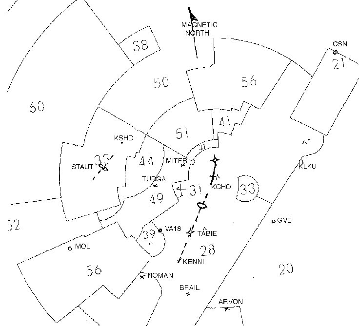
I think it does. There are minimum vectoring altitudes (MVA) ATC uses for vectors. They are just not published for easy pilot access (although there are a couple of samples here and there like this one supposedly associated with Patomac TRACON:

mva.jpg
 
"I think this (IPH) and the AIM language is wrong.
aterpster; I am puzzled on what the ATO guru might have meant by the above quote about the AIM language? I was looking at:

AIM 5-5-2 Air Traffic Clearance

b. Controller.
1. Issues appropriate clearances for the operation to be conducted, or being conducted, in accordance with established criteria.
2. Assigns altitudes in IFR clearances that are at or above the minimum IFR altitudes in controlled airspace.


and wondering if this is what he was referring to, though I have no idea why.


Should you get any further info, please post


thanks, Stan

My guess he was shooting faster than he was aiming. :) I'll try to find out.
 
I think it does. There are minimum vectoring altitudes (MVA) ATC uses for vectors.

VFR aircraft not at an altitude assigned by ATC may be vectored at any altitude. Altitudes assigned to VFR aircraft must generally be at or above the MVA.
 
VFR aircraft not at an altitude assigned by ATC may be vectored at any altitude. Altitudes assigned to VFR aircraft must generally be at or above the MVA.

Beat me to it. Only time I would assign an altitude to a VFR on approach is when they request a radar approach. That way their altitude coincides with 5-9-1 b. & c. Still no requirement to do that of course.
 
I'm well aware. You will frequently get altitudes lower than orocas from atc when being vectored for an approach.

In the context of comanchepilots post, I was just pointing out that there is published guidance for minimum altitudes off airways, for example if you are filing gps direct. Further you should know these orocas along your route, and if you are given an off airway clearance lower than the oroca on the chart, that should prompt you to double check

OROCAS leave a lot to be desired. The OROCA in the Ontario, CA area is 12,100, but the MVAs in a part of that grid are as low as 2,500.

Note the MSA for the attached RNAV IAP; useless.

Because of the work I do, I have access to the civilian TRACON MVAs but not the military TRACON MVAs (even though they cover a lot of civil traffic). I don't have ready access to any Center MIAs, which would be of far more value than OROCAs. MVAs on a sectional chart are quite informative. They (and MIAs) would be a lot more informative on a 21st Century moving map.

MIAs and MVAs would have to become Part 95 altitudes for them to be readily and accurately availble to pilots. The FAA doesn't want that for any number of reasons. Some countries publish at least their terminal area MVAs in their AIP, in which case Jepp charts those.

MVAs in many cases, at least in the west, cause pilots to technically violate 91.177, but that is fodder for a different thread.
 

Attachments

  • F70.pdf
    638.8 KB · Views: 4
MVAs in many cases, at least in the west, cause pilots to technically violate 91.177, but that is fodder for a different thread.

Given that 91.177 includes "or unless otherwise authorized by the FAA", what is the technical violation?
 
Given that 91.177 includes "or unless otherwise authorized by the FAA", what is the technical violation?

Disregard. I had forgotten they made that "end run" change in 2010.
 
Back
Top