Chicago to Vegas

mandm

Avionics Upgrade
Joined
Feb 7, 2020
Messages
3,616
Location
Chicago
Display Name
Michael
Home Airfield
KUGN
Hi everyone,

I’m thinking about flying to Vegas from Chicago. Have any tips, suggestions, lunch stop along the way, PIREPs about the FBO in Vegas / recommended airport/FBO?

Thanks in advance!
 
Anyone flown Wolf Creek pass? At 10,857’, it’s pretty high.
 
Did central Iowa to Vegas c. 2007. Went direct LVS (Las Vegas, NM - funny coincidence) then roughly V263-611 to clear the peaks. Then an impromptu stop at GCN to settle our stomachs after getting our teeth jarred out of our heads for an hour or so, then straight on to HND. Easy peasy, lemon squeezy. I think I went up to 16,500' going west just to say we did (we had O2), but didn't need to go that high to clear the peaks between LVS and SAF.

On the way back, there were storms along the front range, so we went a little farther south and overnighted in ABQ.
 
Looks like an epic trip! I personally haven't flown through the Rockies (always north) but if you're planning this trip in the winter I would fly south of the Rockies through KABQ and hit KSEZ on the way. Not much out of the way... Have fun!
 
I have flown ~500 hrs in the 4 corners area in a 182, and can't wait to fly over it again. World class mountain and desert scenery, from San Juan Mtns to Grand Canyon.
Wolf Creek pass is fine if it's calm and your plane has plenty of lift at those altitudes.

I have been to Henderson several times, both on overnight stays and quick turns, and every visit was perfect, including the ATC handling (all VFR).
 
Did you find this trip report i did last summer? Boulder city fbo worked great. Highly recommend Stearman field as a lunch stop on the way.
 
Did you find this trip report i did last summer? Boulder city fbo worked great. Highly recommend Stearman field as a lunch stop on the way.
Yesss I remember that trip you did too. For this trip I’m thinking end of Feb and I’ll probably leave the dogs at home with a sitter. I’m thinking to fly over the Grand Canyon on the way there. And Zion is definitely on our list and given I’ve read they aren’t really dog friendly maybe this is the time to go. I’m also planning to do an RV trip in May again to Vegas with the pups. Is Kanab a good base for Zion?
 
Is Kanab a good base for Zion?

If you do go to Zion and have the time, Kolob Canyon is worth the drive. It's been years since we toured the area, but we found it practically deserted and well worth the stop!
 
Yesss I remember that trip you did too. For this trip I’m thinking end of Feb and I’ll probably leave the dogs at home with a sitter. I’m thinking to fly over the Grand Canyon on the way there. And Zion is definitely on our list and given I’ve read they aren’t really dog friendly maybe this is the time to go. I’m also planning to do an RV trip in May again to Vegas with the pups. Is Kanab a good base for Zion?
Yeah it worked great. That kanab car rental place was great too. Kanab is almost equidistant from Zion and Bryce. Bryce actually has an airport, but I couldn't figure out a car there. There's a Cuban restaurant in kanab that I would almost make the trip for.
 
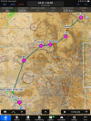
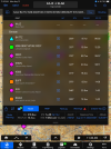
Here is a suggested route to cross the Rockies on the North end. This is obviously a VFR route. This can be flown at 10,500 safely as long as Wx conditions are favorable. This route goes to Delta (KAJZ) but you wouldn't have to fly the last portion, but keep going West at Grand Junction.
 

Attachments

  • IMG_0001.png
    IMG_0001.png
    6.3 MB · Views: 43
  • IMG_0002.png
    IMG_0002.png
    1.7 MB · Views: 38
There are some that wonder if their flatlander airplane has the chops to make a trip out west. I was once too young and dumb to wonder. I just went.

Late July, 1981. Loaded my wife, dog, and some backpacker camping gear into our (85hp) Cessna 140 and headed west out of Chicago. The airplane had no gyros and it's 90-channel Narco was capable of either VOR navigation or VHF communication (but not both at the same time). What more did I need?

Among our stops over the next couple of weeks:

Pierre, SD
Billings, MT
Yellowstone National Park
Salt Lake City, UT
Las Vegas, NV
Phoenix, AZ
Albuquerque, NM
Oklahoma City, OK
St. Louis, IL
Wilmot, WI

Obviously all VFR (and mostly nordo), never went higher than 11,000 or 12,000 feet. Good times, right up until PATCO got frisky and we had to cut the vacation short...
 
Personally I wouldn't take the NA Arrow over the Rockies, and going in February I'd be concerned about weather. But plenty of others here who have experience mtn flying who can advise on that :)

I prefer getting to the southwest via my tried-and-true path of going down to KROW->KELP->KTUS (flying around I-10) -> KPHX... Then you're only an hour and a half from Vegas / Grand Canyon. That offers the best mix of airport availability (decent sized ones that might have mx services if needed), and route safety. It's a very conservative, safe, stress free route IMHO.

But if you're feeling more adventurous and going to cut through the winter mountains, have your pax take pictures!
 
Personally I wouldn't take the NA Arrow over the Rockies, and going in February I'd be concerned about weather. But plenty of others here who have experience mtn flying who can advise on that :)
IIRC, John Deakin had an article or two about delivering brand new NORDO Pipers to Central America way back when.
 
I think finding days that make the tall pointy rocks flyable in the winter are few and far between. Jet stream coming too far south. So i'd say plan a flatter way to go (WY or NM) as plan A, then cross if the weather is perfect (VFR below 15kft and winds below 25kts at 12kft [forecast] is my rule). I like Rollins pass, Wilkerson pass, then Kenosha pass (third) a lot and will add miles to use it over other passes.

Have fun!
 
I did stop in LVS once, long ago, due to weather. And then decided to spend the night because the weather wouldn't improve until much later. I picked a hotel that offered a courtesy shuttle, but it was offered only to those who paid the walk up rate vs. booking an online rate.
 
id pick anywhere else but LVS. The town is several miles away, the fuel is expensive, the courtesy car is rare available and there are no ubers or taxis available. You /can/ rent a car from the used car dealership if you plan on staying a few days, but there isnt much to see, do or eat there. . . lol.

GCN - well its where a lot of the heli's launch from and at least its in/near the Grand Canyon. But I would go anywhere but LVS. Even take Santa Fe or ABQ so you can visit a city. Taos even as its right over the mountain.

As for Las Vegas NEVADA, in a single engine piston or twin - its pretty cheap to land at Atlantic Aviation (make sure you get the PPR). Otherwise, henderson is much nicer than North Las Vegas.

This was ~18 years ago, so I can't remember if LVS was a planned fuel stop or if we 'had' to stop to settle our stomachs. I remember that whole day of flying being pretty brutal turbulence-wise. We hung out in the FBO long enough to get fuel and eat a sandwich (that my wife had packed) and that was about it.

I do know that GCN was 100% an impromptu stop to keep both of us from losing our lunch. I don't even remember where the FBO was - we landed and walked the ramp until found a shady cool-ish spot to sit. It may have even been the entrance for where people were showing up for their aerial tours. We departed a little before sunset to make the final leg to HND just after dark.
 
I used to get to KLVS about once a month and stayed for 1-3 nights. That was back in 2003-07. We keep a car at the airport. I agree that it is not a great place to stop if you want to go into town for a meal.

There are things to see there, and I think they have the best Mexican food. Kocina De Raphael was my favorite with Charlie's Spic & Span Bakery & Café second.
 
Those of us who live out here.....we don't do the hills in the winter with a single engine, even if an arrow. A Pilatus, sure.

The northern route is follow I-80 then drop down thru Utah. Or, once you get to Colorado, before you get to Denver turn south, PUB-4V1 (cheap gas, too!) then climb to 13,000 over LaVeta Pass if the winds allow it. There's an AWOS on top of the pass so you can check before you make the decision. If winds not ok, then continue south TAD-RTN-LVS-OTO then west. You can follow I-40 to Gallup/Holbrook/Winslow or go straight across to Winslow then Flagstaff unless, of course, you want to stop at Sedona (great restaurant on the field) then Flagstaff to Kingman which takes you right into the Vegas airspace. Of course you can also do one of the Canyon routes for the view and watch the world drop out below you.
 
If you do it in winter, I'd suggest an old Dodge with a 440, dark sunglasses, dark suits, some smokes and Sam & Dave playing in the background.
 
Have done Chicago Vegas several times in my Cherokee 180 - Northern route; I-80 then SLC, 'mid' route I-40, and the easiest and longest I-10. The I-10 route has the advantage of lowest terrain and (generally..) best weather. I-40 route has the best (truly spectacular!) views and best stopping places. I normally plan for I-40, and then 'chicken out' down to I-10 if weather doesn't look perfect.
 
id pick anywhere else but LVS. The town is several miles away, the fuel is expensive, the courtesy car is rare available and there are no ubers or taxis available. You /can/ rent a car from the used car dealership if you plan on staying a few days, but there isnt much to see, do or eat there. . . lol.
KLVS is merely an easy waypoint to enter into the GPS to get to the south end of the biggest rocks. I've flown over it many times, never landed!

This was ~18 years ago, so I can't remember if LVS was a planned fuel stop or if we 'had' to stop to settle our stomachs. I remember that whole day of flying being pretty brutal turbulence-wise. We hung out in the FBO long enough to get fuel and eat a sandwich (that my wife had packed) and that was about it.
That whole zone in NM does tend to have some really brutal turbulence.
 
I've done close to that route in spring (April) through the big rocks, but I would never have done so without taking a mountain flying course first. I also had several alternate routes planned for weather. Here was the trip out:
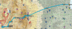
Screenshot 2025-01-30 at 12.09.22 AM.png

KHND plus a rental car was cheaper than the fees at KLAS.

With this sort of thing, I would plan multiple routes, and not return the same way you came. Definitely take a detour to Sedona for a meal, that's a memorable stop and one of the best airport restaurants I've ever encountered. Bryce Canyon is also spectacular; I've stopped for a meal there (IIRC they have a courtesy car but only available when the FBO is open) and then made it an overnight.

An easier route farther to the north is 06C CKW HVE KBCE VPGCB VPGCA CUNDY KHND, that also gets you over Bryce Canyon and the Grand Canyon (be sure you review the procedures for Grand Canyon flying, make sure you have the chart downloaded, and DO IT!).

A good southern route would be 06C LVS RENCO ADABY KSEZ KHND, that will get you to Sedona. You could do the Grand Canyon on this one too.

As far as what's in between... Well, there used to be a nice little restaurant at KOFK Norfolk, NE but I'm pretty sure it's gone unless someone decided to open it back up. Otherwise, there's a whole lotta nothin'. Pack a lunch and keep flying. If you do decide to tangle with the big rocks, there's an excellent restaurant at KAPA, The Perfect Landing. Sedona, as mentioned.

If you end up wanting to RON in the Denver area, KCFO Colorado Air and Space Port (formerly KFTG Front Range) has always provided fantastic service to me. They're not right in town, but there's no traffic between you and the hotels, fantastic service, and cheap self serve fuel. They do have a restaurant on field there too (again, check if it's still open... Sigh).

Were I you, I'd take the northern route one way, the southern route the other way. Probably west and east, respectively, keeping in mind that the southern route gets some bad turbulence so you'll not generally want to go through there in the afternoon.

Have a great trip!

 
I wouldn't recommend flyingcheesehead's route, it takes you over 2-3 high passes: LaVeta, Monarch (rarely recommended) and I can't tell what the third one is from the image, and I don't have a map with me.

If you're serious, Colorado PIlots offers a high-altitude course three times this year - June, Aug, Sept if the schedule is correct - full day ground followed by flight which includes landing at Leadville for your certificate.

coloradopilots.org

Experience wise, I have flown out of Eagle, Leadville, Aspen, and Denver in an Archer (172 in Denver). I’ve also flown over the western hills on the way to Seattle/Alaska. It will be day VFR with acceptable winds.
 
Experience wise, I have flown out of Eagle, Leadville, Aspen, and Denver in an Archer (172 in Denver). I’ve also flown over the western hills on the way to Seattle/Alaska. It will be day VFR with acceptable winds.
Absolutely agree - good weather for our little spam cans. I've done the same in my 180 hp cherokee. Under very favorable circunstances.
 
I wouldn't recommend flyingcheesehead's route,
Note that I didn't recommend it either, I just said I'd done it. ;) I just didn't put pretty pictures on the other two routes. Here they are - And I'd fly it as a loop, myself, to maximize the scenery per dollar:
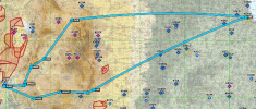
Screenshot 2025-01-30 at 11.11.26 PM.png
it takes you over 2-3 high passes: LaVeta, Monarch (rarely recommended) and I can't tell what the third one is from the image, and I don't have a map with me.
Uh, negative on both of those - It's not a great image, but I was significantly farther north than either one of those. I wish I had a track log, but this flight happened about three months before we started even beta testing track logs in ForeFlight, and I didn't have any panel equipment logging at that time either. Thus, my memory and some lat-longs I put in my logbook are the only record.

We took off from Front Range (I'm calling it that until I see rockets launching from there :rofl:), flying over KAPA and heading up I-70 and hanging a left over Loveland Pass, continued west roughly over US 6 and straight over Dillon Reservoir and Frisco before following I-70 and then CO-91 through Fremont Pass and landed at Leadville (as one does). Visibility was excellent, there was a high overcast, and winds were light (6 knots on the ground at departure).
 
I went twice, once to GCN, another to Salt Lake. To me the easiest, & safest route is I-80 on the North side, or down near Raton, NM, then North of ABQ, near Farmington, southern route. Raton, NM was a good overnight stop.


Back here in the Midwest GPS direct works much of the time, out west not always a great option.
 

Attachments

  • IMG_1058.jpeg
    IMG_1058.jpeg
    209.5 KB · Views: 12
  • IMG_1050.jpeg
    IMG_1050.jpeg
    166.2 KB · Views: 11
Have done Chicago Vegas several times in my Cherokee 180 - Northern route; I-80 then SLC, 'mid' route I-40, and the easiest and longest I-10. The I-10 route has the advantage of lowest terrain and (generally..) best weather. I-40 route has the best (truly spectacular!) views and best stopping places. I normally plan for I-40, and then 'chicken out' down to I-10 if weather doesn't look perfect.
From someone that has flown from SoCal to Wyoming over Vegas, and now from Central Texas to Carson City, NV and Kingman, AZ. I would recommend the above route, as well as going to ABQ, and then follow the 40 west to Kingman, AZ and shoot up from there. I did these routes in a Cherokee 180. The Southern route is the easiest as far as terrain is concerned. The route above has the best views.
 
Note that I didn't recommend it either, I just said I'd done it. ;) I just didn't put pretty pictures on the other two routes. Here they are - And I'd fly it as a loop, myself, to maximize the scenery per dollar:

Uh, negative on both of those - It's not a great image, but I was significantly farther north than either one of those. I wish I had a track log, but this flight happened about three months before we started even beta testing track logs in ForeFlight, and I didn't have any panel equipment logging at that time either. Thus, my memory and some lat-longs I put in my logbook are the only record.

We took off from Front Range (I'm calling it that until I see rockets launching from there :rofl:), flying over KAPA and heading up I-70 and hanging a left over Loveland Pass, continued west roughly over US 6 and straight over Dillon Reservoir and Frisco before following I-70 and then CO-91 through Fremont Pass and landed at Leadville (as one does). Visibility was excellent, there was a high overcast, and winds were light (6 knots on the ground at departure).
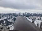
"flying over KAPA and heading up I-70 and hanging a left over Loveland Pass, continued west roughly over US 6 and straight over Dillon Reservoir and Frisco before following I-70 and then CO-91 through Fremont"

In a 172? Then go buy many lottery tickets, you are incredibly lucky. There are high-performance aircraft & occupants buried along Loveland Pass and that route.

Loveland Ski area is a fantastic bowl for skiing, if you're willing to hike up to the top, which happens to be one of the most incredible views, since it's the top of the Continental Divide. The pass (the road) is 12K, and the ridge is 13K, which means you need to be at a minimum 15K .... west bound THERE ARE NO OUTS!!!!! I cannot stress that enough.

There's no AWOS anywhere nearby. The camera's are trained on the highway. None of the (reputable) experienced mountain CFIs, Colorado Pilots Assoc, Civil Air Patrol, or any Colorado-base flight school will ever recommend Loveland Pass. Recommend? h*ll, they'll tell you to get out of the airplane before they go over that pass. CAP has a turbo 206 and won't do it. Even the State's PC12 thinks twice.
 
Last edited:
"flying over KAPA and heading up I-70 and hanging a left over Loveland Pass, continued west roughly over US 6 and straight over Dillon Reservoir and Frisco before following I-70 and then CO-91 through Fremont"

In a 172?
Oh hell no! But OP isn't flying a 172 either.
 
what's he flying?
An Arrow, which granted isn't a whole heckuva lot better.

But again, I wasn't recommending that route, just saying I'd done it. I gave two better routes in the text, but in that first post I did not have them plotted on the map. I followed up after your first reply with a map containing the better routes:

screenshot-2025-01-30-at-11-11-26%E2%80%AFpm-png.137635


And the post you're replying to, I was just clarifying that I wasn't in La Veta or Monarch on the first one either.
 
I like those two routes depicted above, with the minor adjustments. If going that far, line up Monument Valley, the Grand Canyon, Ship Rock, even the Colorado River and Lake Powell if coming from the North. Most are not to far out of the way, making the trip more memorable.
 
Back
Top