Chicago to Santa Monica - routing

ArrowFlyer86

Pattern Altitude
PoA Supporter
Joined
Jul 17, 2019
Messages
1,892
Location
Chicago suburbs
Display Name

Display name:
The Little Arrow That Could
Flying from Chicago (KDPA) to Santa Monica (KSMO) in a single engine piston, what route would you take? (PA28R200)

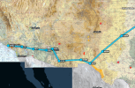
The route I'm considering is essentially Chicago -> El Paso -> Tucson -> Phoenix -> Santa Monica. I really propose this path since I've done the trek to PHX a couple times using this route and I like it (doing it again towards the end of October). Departure would be in ~10 days.

Flight path visually (only focusing on the interesting parts since it's not hard to traverse the mean terrain of Iowa and Kansas):
1694188566058.png


What route would you take? Open to suggestions. Any route recommendations that take me directly through the Rockies probably won't work since I'm both non-turbo and haven't taken a mountain flying course.

Considerations:
- I already have a RT commercial ticket booked just in case I choose not to fly myself
- What's SoCal weather usually like end of September? I'd need to get back to Arkansas for the PoA fly-in on the 29th. I won't have a ton of buffer.
- My friend in LA would love to go flying, which is why I want to fly. But in case I use my commercial ticket -- any recommendations for a place to rent down there? Staying in Santa Monica.
 
An Arrow II is capable of traversing the Rockies and the Sierras if you take the right passes. The bigger issue to me is LA airspace if you're going VFR. You really need to study and understand the VFR corridors and procedures before you get there.
 
An Arrow II is capable of traversing the Rockies and the Sierras if you take the right passes. The bigger issue to me is LA airspace if you're going VFR. You really need to study and understand the VFR corridors and procedures before you get there.
Good to know. Admittedly the LA airspace does look like a gd nightmare. And yeah, this would be VFR.
 
The weather in LA at the end of Sept has been good in past years — a little hot even at the coast and sometimes windy, but otherwise VFR. This Sept, though, has had several MVFR and even IFR mornings at the coast.

For rentals, consider Proteus at KSMO. It has several Pipers.
 
Need a co-pilot?
Let me put this into foreflight and I’ll share my suggestion.
 
I have flown from central Iowa to Las Vegas in a (non-turbo) 200hp RV-7A. I crossed over the front range from Las Vegas, NM towards Santa Fe, NM while wearing O2. I think you could go just a little south from there and stay out of O2 levels pretty easily. Coming back, we overnighted in ABQ and didn't "need" O2 to get past the front range from that angle, but I put it on as we climbed up to 13,000' to catch a heckuva tailwind to go non-stop from ABQ to central Iowa (just to say I did).
 
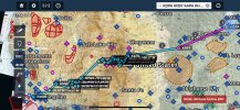
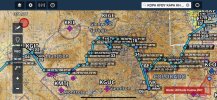
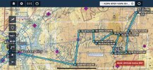
Here’s what I think would be an awesome flight out west!

KDPA-KFBY (SS100LL $5.25)
->KAPA (Denver)
->KANK (SS100LL $5.65 price outdated 3 months)
->KLXV (Leadville - go in the FBO to obtain your certificate for flying into the highest airport in America 9,934’)
->KASE Aspen (if you want to pay the landing fee, believe it comes in the mail, $25/50/100 who knows), you’ll need to go about 12,500-13,000’ for Hagerman Pass
->KGJT (SS100LL $5.80)
->Lake Powell, then the Grand Canyon tour (Read the SATR, avoid the purple areas on Foreflight and Northbound 11,500’ or 13,500’, Southbound 10,500’ or 12,500’ in the corridors, see §93.309)
->KHND (Las Vegas!!) (SS100LL $6.35)
->KSMO (You can clear everything about 8500’ on this leg, or for lower terrain options once you get to Victorville (KAPV) head south towards the inland empire and skirt the northern end westward towards KSMO - the Bravo isn’t really an issue here)

Foreflight route (can you let me know if this link works?)

IMG_4476.jpg
IMG_4477.jpg
IMG_4478.jpg
IMG_4474.jpeg
IMG_4475.jpeg
 
Last edited:
Thanks for the detailed routing suggestion! Yep the foreflight link worked. That's pretty neat, I've never seen a FF web link work like that before.

Re the specifics: it'd be cool to fly from KAPA over the rockies, but that's pretttttttty high altitude. The DA at KLXV is currently a cool 12.2k feet! That's about 4.5k higher DA than anything I've done previously.
Haven't researched the whole route there yet but it looks like I'd need (or want) to have to have O2 on board for cruising that area, and that also would put me in uncharted territory for the arrow in terms of performance (11.5 is highest I've gone yet).
Though I do really like the part of the route that would wind through the grand canyon and give me a day in Vegas :cool:. I'll have to think about this routing and do some research. Mucho gracias for the detailed suggestion!
I did my mountain flying training in an Archer (less power than your Arrow) flying into Eagle County, Leadville and Aspen. I should have training materials somewhere that I could share with you if you’d like (DM me), there isn’t much taught, mountain waves, updrafts/downdrafts, gotta ride them out, and checking the weather cameras and weather. You could also stop in KAPA and go up with an instructor to Leadville Aspen Eagle County and back. I planned a route going through lower terrain as well instead of direct, so it would be easier to follow as long as you have ADSB/GPS etc, don’t go down the wrong valley, be close to the mountain (fly the sides) to give you room to perform a chandelle if you need to turn around. But don’t choke your engine with full rich mixture either. Oxygen won’t be needed, most of the planned route is lower terrain with exceptions for a couple passes that you’ll be higher up momentarily. You’d want to do this day VFR on cooler days or super early in the AM and not at full weight.

Aspen full service fuel is saying $6.15/gallon, maybe you could check out the downtown area too if they have a crew car.
 
IMG_4479.jpeg

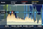
Here is a terrain profile for the route I planned, and you can adjust the route to find lower terrain as well.
 
I did my mountain flying training in an Archer (less power than your Arrow) flying into Eagle County, Leadville and Aspen. I should have training materials somewhere that I could share with you if you’d like (DM me), there isn’t much taught, mountain waves, updrafts/downdrafts, gotta ride them out, and checking the weather cameras and weather. You could also stop in KAPA and go up with an instructor to Leadville Aspen Eagle County and back. I planned a route going through lower terrain as well instead of direct, so it would be easier to follow as long as you have ADSB/GPS etc, don’t go down the wrong valley, be close to the mountain (fly the sides) to give you room to perform a chandelle if you need to turn around. But don’t choke your engine with full rich mixture either. Oxygen won’t be needed, most of the planned route is lower terrain with exceptions for a couple passes that you’ll be higher up momentarily. You’d want to do this day VFR on cooler days or super early in the AM and not at full weight.

Aspen full service fuel is saying $6.15/gallon, maybe you could check out the downtown area too if they have a crew car.
Gotcha .
If I were to do that I think I'd find a KAPA CFI to go up with me at least once to show me the appropriate things. Max DA at takeoff I've done so far is 8000 ft, and climb performance was *not amazing*.

- Definitely learned the hard way not to choke the plane with full mixture! Won't make that mistake again (luckily it was on the ground).
- also learned the value in being light and not always flying with full tanks (which I do pretty much everywhere in the Midwest)
 
Last edited:
If your goal is to get the plane to SMO, then your route is fine.
My primary aviation mission is to enjoy beautiful places from the air, and the American Southwest offers world-class aerial scenery. Canyonlands NP, Arches NP, Shiprock, Monument Valley, Valley of the Gods, Goosenecks of San Juan, Lake Powell, Escalante, Horseshoe bend, Grand Canyon, Zion and Bryce NP.
 
Gotcha .
If I were to do that I think I'd find a KAPA CFI to go up with me at least once to show me the appropriate things. Max DA I've done so far is 8000 ft, and climb performance was *not amazing*.

- Definitely learned the hard way not to choke the plane with full mixture! Won't make that mistake again (luckily it was on the ground).
- also learned the value in being light and not always flying with full tanks (which I do pretty much everywhere in the Midwest)
Head over to the Colorado Pilots Assoc website for a list of incredibly qualified mountain CFIs on the Mountain flying page. Each one has 1000s of hours flying in the Rockies. GPS direct to is not always a good idea in the hills. Get a map, even a paper one, and serious planning.
 
Head over to the Colorado Pilots Assoc website for a list of incredibly qualified mountain CFIs on the Mountain flying page. Each one has 1000s of hours flying in the Rockies. GPS direct to is not always a good idea in the hills. Get a map, even a paper one, and serious planning.
I’m sure someone from POA would be happy to fly with you as well, Denver is a good base.
 
Your route thru ELP is great and can be done at 8.5. Another route, a little shorter and more scenic, is westbound at Amarillo thru Albuquerque, Sedona, HEC vor. This can be done at 10.5 If VFR, then just head towards ONT but head westbound just north of it to DARTS then direct SMO. That will keep you clear of Bravo (you will need to dip below 5k after DARTS, but you will be decending anyway.

I would have both routes ready to go and then choose one over the other depending on the weather.
 
I've done the trip (well, almost - Chicago to Las Vegas NV) - a few times. I always plan 2 options; same as you via ELP and can do it at 8500 or via ABQ at 10500 with the added bonus of stopping of at Alamogordo or other interesting places on the way. I make a final decision on the day; if upper winds above 25kts, I go via ELP.
 
I'm jealous. The route you have is fine. I think people normally cut through ABQ? Definitely grab a Colorado Pilots Association CFI for real instruction if you want to do mountains. I did it a few years a few years ago and they were fantastic!

If you go into the mountains
1) Density Altitude, density altitude, density altitude (Engine (mixture), Wing, Prop, Pilot, P28R gear override, higher GS)
2) if you're in the high country, max load your aircraft to 90% of max gross. That'll help the 200hp engine fly you.
3) clear mountains/ridges/passes by some margin based on winds aloft (think: calm = 500AGL; 10kts = 1000AGL; 20kts = 2000AGL; more= dont go).
4) Make sure you're mega-VFR (few k-ft above tops of mountains, 10-15+ sm viz). Even with mountain training, I won't fly in them with viz under 10.

Aspen is $25 ish to land. Much more if you shut down there. Read up on the VFR procedure, they’ll likely hold you over Snowmass until clearing you to land.
 
When you heading back? You could stop in at kskx and pick me up. Save me from the 22 hour drive home. Will bribe in elk meat.
 
Yep like @kaiser I was going to suggest ABQ and then you get to look at the grand canyon and score those awesome wingtip wednesday photo points. It's basically interstate 40 instead of the originally proposed interstate 10. Both routes are fine. If I was in a 150 and not an arrow, I'd take the I-10 route as it's lower and slightly less bumpy.

That mountain zig-zag into grand junction makes my head hurt, from thinking about it being dribbled off of the headliner. :)
 
I’m sure someone from POA would be happy to fly with you as well, Denver is a good base.
Not everyone on POA in Colorado would be a good choice for an intro to mountains. I've flown here for 20+ years and would NEVER offer to take someone into the mountains and show them the ropes about mountain flying.

The next CPA Mountain class is Sep 23 - all day ground, then schedule with a CFI for the 4-6 hr flight which includes a stop in Leadville to get your certificate.
www.coloradopilots.org

New Mexico Pilots Assoc does a similar program with emphasis on northern NM mtns and southern CO mtns. Coming up same weekend:
 
Last edited:
Gotcha .
If I were to do that I think I'd find a KAPA CFI to go up with me at least once to show me the appropriate things. Max DA I've done so far is 8000 ft, and climb performance was *not amazing*.

- Definitely learned the hard way not to choke the plane with full mixture! Won't make that mistake again (luckily it was on the ground).
- also learned the value in being light and not always flying with full tanks (which I do pretty much everywhere in the Midwest)
Rule of thumb - max 90% of gross weight, learn to lean, lean as you climb, enrich as you descend.
 
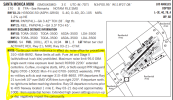
Doing a bit of homework on the LA airspace and then I get to looking at the A/FD for KSMO.

I don't believe I've seen a noise-abatement policy this long in the chart supplement. As a comparison, Midway airport in Chicago is tightly surrounded on all 4 sides by neighborhoods and they land Southwest 737s there early in the morning to late at night, and they have a whopping 1 line noise abatement request... What's with SMO?

1694376063695.png

Midway for comparison:
1694376235099.png
 
I mean who is really playing around not trying to climb to traffic pattern altitude? You climb in 40 seconds, I climb in 45 seconds, what’s the difference.
 
I’ve flown a similar southern Route, once going via ElPaso and another time via ABQ.

one thing I’ll caution is: if you’ve lived your whole life at low elevations: you don’t think you need oxygen “according to the rules” until you are up there… in my case I got a racing/fast heartbeat at only 10k Ft and I needed to turn-on oxygen at 10k and then to cross ABQ, even though I was within the 30-minute limit.

The El Paso route is risky that you have a narrow corridor between Mexico on the south and the restricted areas to the north: usually the air there is dry enough you should be okay, but if you cannot clear it VFR, you might be forced to turn back and then have to fly the long way around north of all the restricted areas. Also ElPaso itself is crazy and I didn’t want to stop there even though it was my halfway point: I stopped at Phoenix Goodyear (GYR) it was a good place.
 
It's California....I'm surprised they didn't include a prop 65 warning because the ink that was printed on is known in the state of California to cause cancer.
The voice in the radios is known to cause cancer too
 
Flying from Chicago (KDPA) to Santa Monica (KSMO) in a single engine piston, what route would you take? (PA28R200)

The route I'm considering is essentially Chicago -> El Paso -> Tucson -> Phoenix -> Santa Monica. I really propose this path since I've done the trek to PHX a couple times using this route and I like it (doing it again towards the end of October). Departure would be in ~10 days.

Flight path visually (only focusing on the interesting parts since it's not hard to traverse the mean terrain of Iowa and Kansas):
View attachment 120435


What route would you take? Open to suggestions. Any route recommendations that take me directly through the Rockies probably won't work since I'm both non-turbo and haven't taken a mountain flying course.

Considerations:
- I already have a RT commercial ticket booked just in case I choose not to fly myself
- What's SoCal weather usually like end of September? I'd need to get back to Arkansas for the PoA fly-in on the 29th. I won't have a ton of buffer.
- My friend in LA would love to go flying, which is why I want to fly. But in case I use my commercial ticket -- any recommendations for a place to rent down there? Staying in Santa Monica.
Lots of detail here… but I have done the routing from Den to CA (based in central coast of CA) numerous times in a 180HP Tiger at near gross. Sure everyone here is suggesting the lowest route across New Mexico and Arizona and that is great, I have done that too… but just as a counterpoint… look at following I-70 from Cheyenne Wyoming to SLC. Take a hard look at a Topo… yes its high but its really flat, has runways all along and takes you right across the Rockies and Wassach with no issues. From there its a stop in Wendover or northern Nevada (outside Reno)… then you only need to make a slow but deliberate climb to the top of donner pass. Easy with 200HP. Truckee will be off on your left if anything goes wrong… once you clear Donner pass, you can descend into the Central Valley (lots of cheap fuel)… if the weather is good, short alternative would be to go to Monterey, then Big Sir to go South. Fuel in San Luis or Oceano (foggy then SMX)… Here is where I can really help.. if you a intimidated by LAX class B VFR.. then fly RZS (VOR) with flight following to Point Mugu (VOR near NAS point Mugu) stay low off shore and follow the coast line as it turns in… keep descending below the Bravo…. Enter near the Santa Monica Pier (it has a VP on the sectional)… then you are lined up to enter the right downwind… No Bravo transition needed. Easy Easy Easy.
 
Thanks for the suggestion. Not a route I had considered previously.
Wondering -- did you mean follow I-80 from Cheyenne to SLC? I think I-70 runs through Denver.
 
Thanks for the suggestion. Not a route I had considered previously.
Wondering -- did you mean follow I-80 from Cheyenne to SLC? I think I-70 runs through Denver.
Sorry I meant I-80. The southern desert route is really pretty for about two hours….. then is just flat and ugly compared to the diversity of I-80, SLC, Wendover, Reno-Tahoe, San Joaquin valley, Salinas/Monterey, Big Sir, Santa Barbara, Pt. Mugu, SMO. The routing I provided for SMO is super easy. Good luck.
 
Lots of detail here… but I have done the routing from Den to CA (based in central coast of CA) numerous times in a 180HP Tiger at near gross. Sure everyone here is suggesting the lowest route across New Mexico and Arizona and that is great, I have done that too… but just as a counterpoint… look at following I-70 from Cheyenne Wyoming to SLC. Take a hard look at a Topo… yes its high but its really flat, has runways all along and takes you right across the Rockies and Wassach with no issues. From there its a stop in Wendover or northern Nevada (outside Reno)… then you only need to make a slow but deliberate climb to the top of donner pass. Easy with 200HP. Truckee will be off on your left if anything goes wrong… once you clear Donner pass, you can descend into the Central Valley (lots of cheap fuel)… if the weather is good, short alternative would be to go to Monterey, then Big Sir to go South. Fuel in San Luis or Oceano (foggy then SMX)… Here is where I can really help.. if you a intimidated by LAX class B VFR.. then fly RZS (VOR) with flight following to Point Mugu (VOR near NAS point Mugu) stay low off shore and follow the coast line as it turns in… keep descending below the Bravo…. Enter near the Santa Monica Pier (it has a VP on the sectional)… then you are lined up to enter the right downwind… No Bravo transition needed. Easy Easy Easy.
NO NO NO! Not I-70 but I-80! I-70 will run you into the side of Loveland Ski Area. And I'll get a CAP text message to go hunting for a smashed aircraft.
 
Speaking of following interstates, it’s interesting that Victor 16 airway is basically following Interstate 10 when west of El Paso/Tucson.

For the Interstate 80 route, check out Victor 6 airway.
 
@ChopAndDrop
Thanks -- that's pretty nifty. V6 actually starts right at my airport's VOR - DPA. How convenient!

@Mtns2Skies
I recall you mentioning that you lived in the Cheyenne area? Any thoughts on the route proposed above about following I-80 westbound?
(Apologies in advance if I totally misremembered that :D )
 
I rather liked the V6/I-80 route since I've never been to SLC (and the flatter terrain is less intimidating).

And I got impatient to start the trip... So now I'm in Cheyenne! Chicago to Cheyenne today. Good flight. Gas stop at KGRI.
Going to hit up the flight school tomorrow AM on some mountain flying/ higher DA training.
PXL_20230914_015556328.jpg
 
Last edited:
I rather liked the V6/I-80 route since I've never been to SLC (and the flatter terrain is less intimidating).

And I got impatient to start the trip... So now I'm in Cheyenne! Chicago to Cheyenne today. Good flight. Gas stop at KGRI.
Going to hit up the flight school tomorrow AM on some mountain flying/ higher DA training.
View attachment 120589
Saw your post about Nebraska; I was also surprised by the vast emptiness of Nebraska. If you happen to need a fuel stop in Nebraska on the way home, grab a crew car, run into town, and go to Runza. Best fast food I've ever had, and only exists in Nebraska for some reason. I find myself looking for reasons to go to Nebraska now, although so far I've been unsuccessful.
 
I rather liked the V6/I-80 route since I've never been to SLC (and the flatter terrain is less intimidating).

And I got impatient to start the trip... So now I'm in Cheyenne! Chicago to Cheyenne today. Good flight. Gas stop at KGRI.
Going to hit up the flight school tomorrow AM on some mountain flying/ higher DA training.
View attachment 120589
How’s Cheyenne? On my list of places to go.

Safe flight!
 
How’s Cheyenne? On my list of places to go.

Safe flight!
So far so good. It's not a big happening town like Denver, but it's nice enough for a couple day stay. I like it so far! Here til tomorrow.

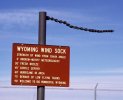
Also the FBO guy sent me this to prepare for training lol.
ALEBL34EqvLmTYnbqOuNPZuk92M1hPdSb6Q4bhCYw7M.jpg
 
Back
Top