TipTanks
Pre-takeoff checklist
- Joined
- Mar 28, 2018
- Messages
- 270
- Display Name
Display name:
TipTanks
Accident Piper PA-32 , 28 Jul 2023
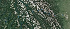
A Piper PA-32 impacted mountainous terrain of Mount Bogart, near Kananaskis Village, Alberta's Rockies, Alberta. <br />The six occupants died and the aircraft was destroyed.
aviation-safety.net
This one is brutal. Coming across the Rockies from Calgary area towards the BC Okanagan. 6 Young men dead, a few fathers, one father to be... has rattled the GA world up here for sure.

") Thanks.
Thanks.