Check TAF discussion and radar...

ArrowFlyer86

En-Route
PoA Supporter
Joined
Jul 17, 2019
Messages
3,285
Location
Around
Display Name
Flight
There was a thread recently about potentially declining weather forecasting quality. I'm not saying this is it, but in my flying I haven't found many cases like this that seem to miss such a blatant weather dynamic (except the military TAFs I mentioned in another thread). Four photos below kind of tell the picture.

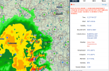
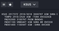
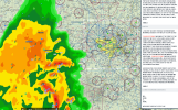
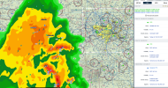
Context: A friend asked me this morning to fly down to St Louis this afternoon and I did my usual glance at the TAF (the coded TAF only, not discussion) for destination KSUS, thought it'd be a nice VFR flight so I agreed to fly. Then just now I load up WX radar, here's the picture. A fairly fast moving, big blob of thunderstorms and rain stretching all the way from (almost STL) SW to Oklahoma that should reach St Louis in like 30 minutes. Yet if you just look at the TAF code, you'd never know it. Everything looks totally rosy until 4am tomorrow. Obviously, I'm not flying through that. Trip cancelled.

Looking at time lapse wx radar, it doesn't seem like this popped out of nowhere. So how could something like this not be reflected in the TAFs or added to it as some kind of urgent update? Am I crazy, does that not seem a little strange? KSTL TAF showing similar.
1745943967058.png
1745944002421.png

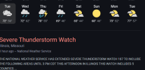
Even Google gets it (when checking wx for St Louis)
1745944726757.png

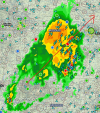
So this blob, on this trajectory isn't noteworthy enough to be in the TAF for StLouis
1745944927416.png
 
I'm seeing this a lot too. Where TAFs at the far outer edge of their forecast window - say 18-24 hrs out - can be very inaccurate. Same-day TAFs I've found still OK.
 
I'm seeing this a lot too. Where TAFs at the far outer edge of their forecast window - say 18-24 hrs out - can be very inaccurate. Same-day TAFs I've found still OK.
Yeah, I always ascribe more leeway and uncertainty to the forecast windows that are further out. Which is why I found this a bit of an abberation, cuz 54 mins ago is when I snapped that TAF saying nothing but pure VFR and no chance of rain, and now an hr later the METAR for SUS (predictably). I'm no wx forecaster, so I know the professionals who manage their TAFs wouldn't ordinarily miss such an event?

1745948054960.png
 
Blob may not have existed when the TAF was made. Path may have changed. Sometimes they dissipate. Hence the value of watching radar for some time before the flight to see if the TAFs and general forecast makes sense. This TAF seems to indicate that at least one blob was thought to pass south; sometimes that's only an educated guess.
 
I went and looked at the TAF history. It had storms in every one for the last 24 hours except for the odd 1211z TAF. Weird. Why have a TAF at 1120 and then 1211?
 
Blob may not have existed when the TAF was made. Path may have changed. Sometimes they dissipate. Hence the value of watching radar for some time before the flight to see if the TAFs and general forecast makes sense. This TAF seems to indicate that at least one blob was thought to pass south; sometimes that's only an educated guess.
Yeah, but when I looked at radar time loop it appears that it's been barreling that direction for some time now.
And normally they do some update to the TAF, even if it's in-between their normal publish interval if the wx is expected to change enough, right?
Seems sort of asleep at the wheel when the storm is at your doorstep moving 50+ mph and you're still forecasting rainbows and unicorns.

And yet, at other times the TAF can be overly pessimistic - :crazy:
Yeah... Though a lot of times the most pessimistic ones might say "30% probability" or something. Something indicating it's not going to be all doom + gloom.

Well they have it now. Better late than never. :dunno:
The same can be said about me eventually, finally checking radar!
 
It can be incredibly difficult if not fundamentally impossible in some cases to predict convection in the terminal area. Here's a perfect example.

Here are the TAFs today for KCLT (most recent at the top). At 1516Z (bottom), no mention of any precip or convection. The 18Z issuance adds a TEMPO group for TSRA because a line of storms moves in to the southwest of the airport. Then that line began to fall apart and they amended the TAF to include a TEMPO group for SHRA. CLT didn't get a drop of rain or report convection.

View attachment 140596

Then you can see the surface observations with TCU reported, but no rain or thunder.

View attachment 140597

Here's the radar depiction at 19Z. A line of convection moving to the east/northeast.

View attachment 140598

But by 2130Z, that line had completely fallen apart.

View attachment 140600

As it turns out, the forecast from the HREF model issued at 12Z did a fantastic job showing the dissipating line. Red arrow points to the line in question. Left is 19Z and right is 22Z. Notice how it accurately depicted that this line would dissipate.

View attachment 140602

It appears the first TAF nailed it, but the next forecaster felt that line might actually make it to cross through that tiny little 5 SM forecast area. If that line would have held together for another 40 miles, the TSRA forecast might have been correct.
Thanks Scott.

My follow-up question would be, as the time draws near (as it did in my case where the storms were not even 30 minutes from barreling into StLouis at 50MPH), don't those models tend to point towards an unambiguous outcome? I can understand at further time periods why you might leave it off the TAF, but I have to think that when you start to get closer it becomes pretty clear what is going to happen?

And when the weather in the TAF differs so substantially from reality, wouldn't it normally trigger an update of some kind once the storm was knocking on their door? Going from pure VFR no rain, to heavy rain, IFR, no viz + thunderstorms in the span of 45 minutes seems like someone asleep at the wheel -- no?
 
I don't know what guidance they were using for this particular situation. So it's hard to know for sure. But it appears they felt the bulk of the precipitation would pass south of the STL area. If you look at the 12Z 3km NAM, 12Z WRF-ARW and the 12Z HRW-FV3 model it does show that. So much of the model guidance was poor.

A majority of the heavy convection did pass to the south of STL as you can see from this NEXRAD image.

View attachment 140610

From an amendment standpoint, the forecasters should have had at least VCSH or SHRA in the TAF given the weather was more north than forecast. I do think there's a lot at play here. More and more of the forecast offices are not launching weather balloons. So this will decrease forecast accuracy in the models.

You can read this post I made about TAF amendments. There are many forecast offices that have gone to a minimal staff due to the cuts and retirements and it's possible that the TAFs for amendments may get left behind especially when there's significant weather in the area. I don't know if this was the case for St. Louis.
Thanks!

Are wx balloons particularly helpful for convective predictions? I'm actually not sure which information they're best at relaying.

And regarding your weather update post, this seems like the part I was thinking about most relevant:

"Once the TAFs hit the wire, the forecaster must continue to compare the forecast to the actual observations for the airport to be sure it accurately depicts the ceiling, visibility, wind and weather occurring at the airport. When there is a discrepancy or the forecaster feels that the TAF isn't representative of the weather that may occur in the terminal area within the TAF's valid period, they will issue what is called an unscheduled TAF, better known as an amendment."

^i guess I expected StL to act faster than they did. But it's just one observation, I have no idea if it's a pervasive problem (yet) or not.
 
Forecasts in this area have been pretty inaccurate over the past week or so. I keep checking weather and find even the general forecast seems to change every couple of hours. Partly cloudy, showers, scattered storms, or storms- who knows? Wait an hour and it will be different. TAFs haven't been a lot better.

Might just be spring in the midwest but it definitely does seem significantly less accurate than usual. My interpretation of conditions like this where it frequently changes is that they know there's moisture in the air and they expect some precip but they're not sure where, when, or if it will develop into storms. You pretty much have to fall back on trying to read the trend in the radar.
 
In general, the National Weather Service is definitely off it's game.
Two days ago the local report for overnight was 40 degrees, partly cloudy, possibility of rain, and a frost warning. It had been in the mid-70's all day.
Today was 95% chance of rain until 6:00PM. It rained for 20 minutes about 1:00 AM and nothing since.

It's like someone is just randomly stringing together weather words.
Of course, if these forecasts are based on the IBM Watson systems, it probably is just random weather words.
 
Reading all this, one best have their CC ready for that unexpected delay and stay over night, if you are doing any significant XC.
 
yea i flew into Columbia MO that morning. I just figured that the forecaster didn't think the northern edge would extend that far. It was a bumpy ride around the north end of the system but smooth in rain on the approach with a reasonable ceiling and decent visibility.
 
Just chatted with a few of my colleagues today and things are much worse than I thought. Out of the 122 forecast offices, 30 don't have an MIC (meteorologists-in-charge). Not having an MIC means another forecaster who assumes that role will not be doing essential forecasts, issuing warnings, updating TAFs, etc. Found out that the Goodland, Kansas office has had to shift to a non-24-hour operation. Appears that about a dozen more offices in the Plains area and Pacific NW are poised to transition to this as well. There are 90 vacancies for folks that repair the NEXRAD radars and ASOS sites. They can't fill these due to the hiring freeze. Nearly 600 NWS employees were fired or retired since early February. All in all, this is pretty risky stuff...especially that hurricane season starts on June 1.
It was right there on page 674 of Project 2025 all along...

Screenshot 2025-05-02 at 11.53.00 PM.png
 
Without turning this into a political debate and getting banned, there are many things the government does that should be done nationally, and are good for our citizens/nation. There are many things the government also does that don’t benefit the citizens. Two things for sure that the government should do that each state can not do individually are Air Traffic Control Services and National Weather Services/Forecasting. A shame to see these uniquely qualified government services being reduced.
 
I like to check the forecast discussion. Sometimes there are some good nuggets in there as to why the TAF says what it says.
 
Given that the NWS is a 24/7 organization, they were already stretched pretty thin before all of the terminations and retirements. When the weather is fair, this wasn't an issue. However, when severe weather is expected, they usually bring in more forecasters (some on their day off) so that there is ample coverage to issue the necessary warnings and advisories. Many forecast offices don't have the staff now to support this. Worth noting, seniority doesn't imply they get to work the day shift...all employees are required to work all three of these shifts regardless of their seniority.

I know a few of my colleagues that were recently promoted (but considered probationary because of their new job description) and then terminated are now working in Europe and Canada helping them to advance their science in meteorology.
Hate to see the baby thrown out with the bath water, too - perhaps a carving knife (or scalpel) would have been a better approach, vice a chain saw. But a significant house cleaning is needed. After decades as a Fed employee and Fed consultant, oh, yeah, it's needed.
 
Really, at the NWS? Have you ever visited a weather forecast office on a busy weather day? It's pretty insane how few people they have given what they are asked to do.
I can't speak to the folks doing the weather guessing; I imagine NWS contracting, purchasing, budgeting, HR, and management structure could be looked at. Maybe it's fine? I guess that's possible.
 
The contractors are the ones that support the systems that NWS meteorologists use. So when a computer system goes down, are you okay getting rid of that person who is responsible for fixing it? Or when a NEXRAD radar goes out, let's get rid of those people too? Honest questions. Yes, they've terminated or severely limited those contracts as well. So management structure...out of the 122 WFOs, they have lost 30 meteorologists-in-charge or 25% of the management structure. I wish that I could tell you to visit your local WFO and see for yourself...but they don't have the staff to support any visitors (I tried to set up a visit to four different offices and they couldn't support it).

I travel the country and visit these WFOs and without charging the government and set up two hour or so "chalk talks" with them so they better understand the needs of general aviation pilots - most of them are not pilots. I try to emphasize key points of what is important to put in the forecast and the area forecast discussion. While not all of the forecasters attend my talk, those that do have a better appreciation for our needs. Right now, many don't have the administrative staff to support this.
I defer to your experience - I suggest the administrative side might be worth a peek?
 
…As you might imagine, this would mean they would be considered probationary employees if they switch positions...and we know what will happen to them during the next round of cuts that are coming up. So that ain't happening.
That’s an interesting take. I’d like to see what box 24 of a career tenure SF50 contains and what the agency relocation offer states.

Usually no change in GS-series or level can change tenure unless a new appointment is made.
 
As part of the DOGE program did they allow drugs to be smoked on the job at NWS? Curious about smoking crack specifically.

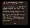
Our phones went nuts out here impending of a dust storm. While technically possible I guess, it would be the first time in about 40 years living in this area that I witnessed such a thing.

Screenshot_20250516-182412~2.png
 
As part of the DOGE program did they allow drugs to be smoked on the job at NWS? Curious about smoking crack specifically.

Our phones went nuts out here impending of a dust storm. While technically possible I guess, it would be the first time in about 40 years living in this area that I witnessed such a thing.

View attachment 141113
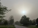
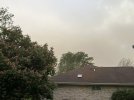
Nope, that was totally real. A friend of mine who lives in Chicagoland saw the same alert, blew it off, and then ended up taking these pics:

498671363_10104857045289835_7068236218831272038_n.jpg497741994_10104857045120175_181390459830542508_n.jpg
 
I flew yesterday (KC area). Visibility was really bad for a few hours from dust. That’s probably what Chicago got today.

Parts of I-70 in western KS were closed.

Back in March a dust storm crossed that Interstate and started a 70+ vehicle pileup that killed 8 or 9 people. I saw a dashcam video that showed visibility going from unlimited to zero in seconds.
 
Wow! I would have bet money it was a joke!

I've never once seen a dust storm here. In AZ, sure, but here?
It's definitely not a normal occurrence in this part of the world. I'm more used to seeing what we saw here yesterday, where the sky turned funny colors and there were tornados. Several hangars at KUNU took some damage, not sure of the fate of the airplanes inside.
 
It's definitely not a normal occurrence in this part of the world. I'm more used to seeing what we saw here yesterday, where the sky turned funny colors and there were tornados. Several hangars at KUNU took some damage, not sure of the fate of the airplanes inside.
This is why I stayed on the ground yesterday. RST was G41. No thanks. Mod turb under 10 reported all across IL and IN. Nope.
 
Wow! I would have bet money it was a joke!

I've never once seen a dust storm here. In AZ, sure, but here?
NWS Illinois posted on social media that it was only the second time in their history that they'd ever issued a dust storm warning, and it was the first ever for Chicagoland.
 
NWS Illinois posted on social media that it was only the second time in their history that they'd ever issued a dust storm warning, and it was the first ever for Chicagoland.
Oh, and I think they said the dust came from @Jim K's farm. :rofl:

OK, not JUST his, but that winds were whipping from the south and the dust was stirred up from farm fields. So some of it probably did.
 
Oh, and I think they said the dust came from @Jim K's farm. :rofl:

OK, not JUST his, but that winds were whipping from the south and the dust was stirred up from farm fields. So some of it probably did.
That particular day, it rained here, so all that dust was from north of anything I farm. I'll also say this....some farming practices are much more susceptible to wind erosion. Although I use "conventional" tillage, I select my implements and practices to leave a significant amount of material from the previous crop on the surface, which disrupts the wind at the surface and prevents (for the most part) soil loss. I see, particularly among the very large operations, a trend towards more tillage, and wanting to eliminate all the "trash". The high-speed "vertical tillage" tools these big guys favor do a great job of pulverizing the soil and old crop material...looks like brown flour when they're done. Then the slightest gust of wind will pick a bunch of it up. Before long, the government will dictate what we can & can't do, and it will be a massive overreaction.
 
That particular day, it rained here, so all that dust was from north of anything I farm. I'll also say this....some farming practices are much more susceptible to wind erosion. Although I use "conventional" tillage, I select my implements and practices to leave a significant amount of material from the previous crop on the surface, which disrupts the wind at the surface and prevents (for the most part) soil loss. I see, particularly among the very large operations, a trend towards more tillage, and wanting to eliminate all the "trash". The high-speed "vertical tillage" tools these big guys favor do a great job of pulverizing the soil and old crop material...looks like brown flour when they're done. Then the slightest gust of wind will pick a bunch of it up. Before long, the government will dictate what we can & can't do, and it will be a massive overreaction.
Interesting. I would think of "conventional tillage" as being the old-school rollover plows which seem to be practically dead. I couldn't even find one on JD's web site. What do you use? What do the big operations use?

I'm not, nor have I ever been, a farmer... But my dad grew up on a farm and was a dairy science professor so I consider myself "farm adjacent" :rofl: I think he said the rollover plowing released a lot of the nitrogen from the soil and that's why it's generally not done any more.
Plowing pretty much ended due to wind erosion. My dad plowed still when I was kid in the late 80s, which was the tail end. I remember the snow in the ditches turning black in those days.

When everybody switched to "chisel plows" that stopped. The chisel plow lifts the soil up instead of turning it over, leaving some residue on top. A chisel pass in the fall followed with a shallower field cultivator pass In the spring was originally called "conservation tillage", but as moldboard plowing went away, it eventually became the standard and picked up the "conventional tillage" moniker.

Three things I'm seeing more of that I think are part of the problem
1) fall tillage tools that have multiple sets of discs, and leave the soil about as bare as a moldboard plow. The chisel I use has discs, but they're adjusted to be less aggressive and only buries about 25% of the residue.
2)fall chiseling of soybean stubble, which leaves the soil bare all winter
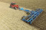
3) these "high speed discs" they do an almost unbelievable job of pulverizing the soil &residue. Better than a roto-tiller, and coupled to a 600+hp tractor capable of working 40' at 15mph. After one of these things goes through, even a 10mph wind will raise a cloud of dust.

images.jpeg
 
…
3) these "high speed discs" they do an almost unbelievable job of pulverizing the soil &residue. Better than a roto-tiller, and coupled to a 600+hp tractor capable of working 40' at 15mph. After one of these things goes through, even a 10mph wind will raise a cloud of dust.

View attachment 141180

Dang. What you’re doing sounds like what I remember doing in college. This last contraption may be efficient, but it doesn’t seem to promote conservation practices as I remember them.

I will say the little bit of land I was helping work likely used different practices than larger operations.
 
Before long, the government will dictate what we can & can't do, and it will be a massive overreaction.
State? Feds?

Iowa has a display in one of their rest areas along I-80 showing the progression of their agriculture industry and later soil conservation efforts that was pretty interesting. Probably the earlier "something" happens, the less of an overreaction it is. Unfortunately, those large farming operations likely don't have the future good of agriculture in the state on their minds, they're going to extract maximum profits for minimum effort for as long as they can until there's a crisis and the government makes them do better. :(
 
There was a thread recently about potentially declining weather forecasting quality. I'm not saying this is it, but in my flying I haven't found many cases like this that seem to miss such a blatant weather dynamic (except the military TAFs I mentioned in another thread). Four photos below kind of tell the picture.

Context: A friend asked me this morning to fly down to St Louis this afternoon and I did my usual glance at the TAF (the coded TAF only, not discussion) for destination KSUS, thought it'd be a nice VFR flight so I agreed to fly. Then just now I load up WX radar, here's the picture. A fairly fast moving, big blob of thunderstorms and rain stretching all the way from (almost STL) SW to Oklahoma that should reach St Louis in like 30 minutes. Yet if you just look at the TAF code, you'd never know it. Everything looks totally rosy until 4am tomorrow. Obviously, I'm not flying through that. Trip cancelled.

Looking at time lapse wx radar, it doesn't seem like this popped out of nowhere. So how could something like this not be reflected in the TAFs or added to it as some kind of urgent update? Am I crazy, does that not seem a little strange? KSTL TAF showing similar.

View attachment 140492
View attachment 140493

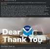
Even Google gets it (when checking wx for St Louis)
View attachment 140495

So this blob, on this trajectory isn't noteworthy enough to be in the TAF for StLouis
View attachment 140496
I think your first picture says a lot. The 12Z TAFs seemed to be based on the 0617 local (1117Z) aviation discussion, which indicated the forecasted morning and early afternoon storms were going to stay south of the area. At that time, the leading edge of the mesoscale convective system (MCS) in question was still back near Independence, KS, 260NM away. Indeed several of the 00z convective allowing model (CAM) runs showed that MCS staying south of the STL area, arriving closer to 19 or 20Z and/or dissipating. The closest model to being accurate as to the arrival of the MCS was the HRRR. But the MCS did not do what most of them predicted and instead went much farther north, much faster than expected, arriving closer to 17Z (12PM local).

At 1243 local, the aviation discussion was updated, but didn’t go into effect until the 18Z TAFs, which was after those storms had moved through. Whether budget cuts limited the bandwidth to issue an amended TAF isn’t readily discernible in this case, but as Scott pointed out, a lot of the extra folks who contribute to said bandwidth required to do timely updates are gone.
 
State? Feds?

Iowa has a display in one of their rest areas along I-80 showing the progression of their agriculture industry and later soil conservation efforts that was pretty interesting. Probably the earlier "something" happens, the less of an overreaction it is. Unfortunately, those large farming operations likely don't have the future good of agriculture in the state on their minds, they're going to extract maximum profits for minimum effort for as long as they can until there's a crisis and the government makes them do better. :(
Federal, I think. There's a bunch of farm programs that kick in at certain price levels. Sometimes they are the difference between surviving and going broke. More often they're the difference between a new Superduty or a new King Ranch Superduty. Anyway, regardless of how you feel about "farm support", everyone signs up for these programs and jumps through the necessary hoops, which is largely reporting your plantings. That's where the government and the CBOT gets their data on how much of each commodity is being produced. They get the yields on the back end through the (federally subsidized) crop insurance program. Point being, if they say "you're only allowed X units of N", or "you're going to use cover crops"....they have the big carrot/stick of denying you access to all these programs.

The states could also legislate this stuff, but they tend to have less teeth and the farm lobby is pretty good at being heard in the state houses. Now, if these dust storms in Chicago become a regular thing, there's not enough downstate legislators to have any say about anything. That said, if they become a regular, thing, something needs to be done; it just seems like farm policy created by city folks is a dangerous thing. There was a big pileup on the interstate near Springfield a couple years ago https://abc7chicago.com/illinois-dust-storm-pile-up-interstate-55-accident-i-crash/13203789/, which spurred the creation of the NWS dust storm alert they issued this week. I don't think it will take many of these events to bring about legislation. As you said, it seems like a big percentage could care less about long term soil health and effects on others. It's hard to claim we're being good stewards of the soil when it's being deposited in the suburbs.
 
Back
Top