Sinistar
En-Route
- Joined
- Sep 9, 2016
- Messages
- 3,712
- Display Name
Display name:
Brad
All this Canada talk lately, figure we're close so time to take quick trip across the border and figure out how it all works.
Outbound: KGYL -> KTWM (Fuel) -> CYQT (Thunder Bay, Customs)
Return: CYQT -> KDLH (Duluth, CBP, Fuel) -> KGYL
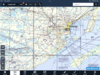
Then I started looking at sectional and seeing stuff I don't normally see up here. On the way up there is one MOA (Snoopy) which starts at 6000msl so no problem there. But the sectional on the Canadian side has some markings I don't recall or have never seen. See image. Curious what all the items in Green Circles mean if anyone can help? And that weird marking North East of the city - no clue?
We already have the sticker and eAPSIS login stuff. Same goes for CPB contact numbers for (return) and obvious 1888CANPASS for the way up. Both pilots are 3rd class medical and we have ADSB-OUT. Will file VFR flight plan and FF on the way up. Obviously we'll file VFR flight plan on the way back. As well as the eAPSIS forms and timing of everything. We have proof of insurance, registrations, checking plane for radio license thingy, etc.
Anyone have any recommendations for restaurants or places to see?
Topping off at KTWM gives us enough fuel and reserves to not need fuel in Canadia at just shy of $10/gal. And maybe enough to get back to our $5.80/gal

Outbound: KGYL -> KTWM (Fuel) -> CYQT (Thunder Bay, Customs)
Return: CYQT -> KDLH (Duluth, CBP, Fuel) -> KGYL
Then I started looking at sectional and seeing stuff I don't normally see up here. On the way up there is one MOA (Snoopy) which starts at 6000msl so no problem there. But the sectional on the Canadian side has some markings I don't recall or have never seen. See image. Curious what all the items in Green Circles mean if anyone can help? And that weird marking North East of the city - no clue?
We already have the sticker and eAPSIS login stuff. Same goes for CPB contact numbers for (return) and obvious 1888CANPASS for the way up. Both pilots are 3rd class medical and we have ADSB-OUT. Will file VFR flight plan and FF on the way up. Obviously we'll file VFR flight plan on the way back. As well as the eAPSIS forms and timing of everything. We have proof of insurance, registrations, checking plane for radio license thingy, etc.
Anyone have any recommendations for restaurants or places to see?
Topping off at KTWM gives us enough fuel and reserves to not need fuel in Canadia at just shy of $10/gal. And maybe enough to get back to our $5.80/gal