I am not absolving the crew of any responsibility here, but I for one am not going to pass too harsh of judgement on them.
Back in my 737 days, we were flying from Chicago to Harrisburg, PA. It was a nice clear night, visibility forever. Approaching Harrisburg, ATC gives us a bearing and distance to the airport. We look, and there is a nice brightly lit runway in about the location ATC mentioned. So we call the airport in sight and get cleared for a visual.
Now, just so you know, it is SOP at UAL to have the ILS (or whatever approach is being used) tuned in for backup guidance to whatever runway being used.
So, we have the field in sight, the localizer looks about right, and we proceed on down for a visual approach. Everything is looking good when one of us looks at the glideslope and we are pretty much full deflection low. WTF? Well, turns out, we were actually approaching Capitol City airport, which is just 4 miles west of Harrisburg, and very close to the same alignment. Not to mention the fact that their runway lights were on high intensity and Harrisburg's were on low intensity.
If we were operating strictly by visual references, we would have landed at the wrong airport.
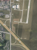
I don't know what time of day it was with these guys in Wichita, but given the fact that there are a lot of runways there in close proximity to each other, I can totally see how this happened.