Bird Migration Maps

Roland Donnell

Pre-Flight
Joined
Aug 30, 2019
Messages
63
Location
Plano, Tx
Display Name
Roland Donnell
Home Airfield
T31
I don’t live under a rock but just recently became aware of this web site. Pretty amazing. Real time and forecast.

 
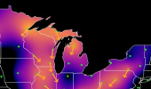
That is interesting. I find it odd that birds don’t migrate over the Great Lakes or large bays.
 
Very interesting site. Around me it’s pelican migration season. Tens of thousands fly the Mississippi River. They like to stop over in a large basin maybe 5 miles from a class D, but they seem to roost at night.
 
I’ve been watching online bird migration radar data, maps, and on the ground reports (ducks unlimited has pretty good spotter reports) for a few years now, not for aviation, but for agriculture (avain influenza/forcast for times of heightened biosecurity risks). I have noticed that there are areas around the USA that have limited radar coverage at low levels simply due to the “line of site” nature of the doplar radar they use and the radar site locations. The websites are pretty good at establishing base lines, but if it is a low ceiling day/night they miss a lot of movement in these areas.
 
birds generally don't fly IMC. They're smarter than us, sky's their wheelhouse after all.
 
That is interesting. I find it odd that birds don’t migrate over the Great Lakes or large bays.

It appears to me that the data is being constrained to the landmass boundaries, which doesn’t necessarily mean birds aren’t crossing the lakes.

Birds.png
 
Birdie birdie in the sky,
why'd ya do that in my eye?
Aren't cha glad that cows don't fly.??
 
Back
Top