ADS-B inaccuracy and certificate action

You need to speak face to face with inspectors. I can’t imagine anything more than a nothing burger from this unless something else is actually off. Most I’ve personally met are very reasonable humans.
OP needs an aviation attorney to speak for him. the FAA has already initiated action... this is not a brasher warning.
 
Send a letter/email to the FAA to save the ATC communications for this date for future legal evidence. Be specific about which ATC you are requesting, and be accurate

I received a letter from the FAA recently proposing a 1-year certificate suspension

Since at this point there has been the initiation of formal enforcement action, the FAA has already saved it, and the odds are it's not helpful to the pilot. (I agree completely about doing your own research on LiveATC.)

What strikes me as odd about this is that, based solely on the description given, I would expect something like this to be handled under the Compliance Program. Even if it weren't, there's correspondence that normally precedes a Notice of Proposed Certificate Action from an FAA lawyer (unless its serious enough for emergency revocation rather than suspension). The proposed 1-year suspension suggests to me that there is far more to the story.
 
The only advice I could offer is to not take any advice from Trent Palmer ... ;)
 
What altitude and where were you at when ATC told you to hold? And did ATC say, "Hold," or just, "Remain outside of the Class B"? Had ATC put you at the altitude you were at in the place that you were at to begin with?

I assumed based on the OP that this was a formal IFR hold on a fix and course. In that case, the OP only had 2 choices. Violate the FAR minimum altitude, or refuse the instruction.

But now it's sounding more like "hang out outside of the Bravo until we are ready for you." In that case, it would totally on the pilot to select a location and altitude that complies with FAR minimum altitude regs.
 
Do you have the actual data (ADS-B and Mode-C) from the FAA for the time in question?
If not, why not? You can't do anything until you understand what data is being used against you.
Does the Mode C from your transponder match the baro altitude from the ADS-B?
Does the GPS altitude correlate to either reported baro altitude?
What was the altimeter setting at the time in question?

Can you tell us where exactly you were and how you got there?
Over Mission Bay approaching from Mt Soledad
 
It would probably be wise at this point to shut up and consult with a professional.
They can't help themselves but to talk online about this, all over the internet, despite early advice to lawyer up.
 
Personally, I would not file a NASA report. It's way after the alleged transgression and after the FAA has initiated action. "anything you say can and will be used against you"
 
Personally, I would not file a NASA report. It's way after the alleged transgression and after the FAA has initiated action. "anything you say can and will be used against you"

§ 91.25 Aviation Safety Reporting Program: Prohibition against use of reports for enforcement purposes.​

The Administrator of the FAA will not use reports submitted to the National Aeronautics and Space Administration under the Aviation Safety Reporting Program (or information derived therefrom) in any enforcement action except information concerning accidents or criminal offenses which are wholly excluded from the Program.
 
Great question and headed down the path of what I am trying to solve here.

I am using a uAvionix system that has its own barometric pressure sensor and does not use the altitude encoder. My testing has shown the altitude reports from this are way off. The FAA won’t accept that testing, however. They are claiming they would have already been notified by a PAPR if the altitude was off.
what does the uAvionics system use for a static source? Where is it located? If it doesn't use the aircraft's static system, the altitudes certainly won't match.

Ron Wanttaja
 
what does the uAvionics system use for a static source? Where is it located? If it doesn't use the aircraft's static system, the altitudes certainly won't match.
SkyBeacon and TailBeacon have their own built-in baro sensor in addition to the built-in GPS. I don't know whether the standard PAPR has enough detail to compare them, but you can request full ADS-B details for any of your flights by emailing the FAA. I did this a few years ago when troubleshooting mine, and it was very helpful.

The email address I used: [email protected]
In the email, include your tail # and the date of your flight.
 
Last edited:
SkyBeacon and TailBeacon have their own built-in baro sensor in addition to the built-in GPS. I don't know whether the standard PAPR has enough detail to compare them, but you can request full ADS-B details for any of your flights by emailing the FAA. I did this a few years ago when troubleshooting mine, and it was very helpful.

The email address I used: [email protected]
In the email, include your tail # and the date of your flight.
Do you know if the SkyBeacon and TailBeacon use only the built-in baro sensor data, or do they use both the built-in plus the Mode C altitude encoder? The FAA is telling me that the uAvionix ADS-B units "correct" the Mode C encoder data by using the built-in baro sensor. This just doesn't seem right to me.
 
Do you know if the SkyBeacon and TailBeacon use only the built-in baro sensor data, or do they use both the built-in plus the Mode C altitude encoder? The FAA is telling me that the uAvionix ADS-B units "correct" the Mode C encoder data by using the built-in baro sensor. This just doesn't seem right to me.
Here's now uAvionix explained it to me when I was troubleshooting my unit. The only thing they get from the xponder is the current squawk code. They do it by sensing ripples on the power input that happen when the xponder is pinged and responds, drawing power to transmit. Any altitude data they send comes from their own internal GPS or baro sensor.
 
I received a letter from the FAA recently proposing a 1-year certificate suspension due to a couple of holds over sea level populated areas where my ADS-B reported altitudes as low as 800'. I was told by ATC to hold at 1000' or below, and I was holding 1000' exactly. Of course I was shocked to receive this letter and I started testing out my ADS-B in flight to compare to my altimeter. On the ground, the ADS-B reported 100' low and once in the air in a level hold it would read as much as 300' lower than my altimeter. I recorded this on video and submitted it to the FAA. Their response was that if my ADS-B was that far off from my Mode C, they would have received a PAPR alert at the local FSDO and would have contacted me. Is this true?

How did they know who was flying the airplane? Was there a flight plan that listed your name and phone number?

I bring this up because a few months ago, I got a call from the FSDO about our club plane allegedly circling at low altitudes. I explained to him that we were flying over our home field for an engine break-in. The inspector said he already knew that, was aware of our recent engine replacement, and apologized for the call. He mentioned that someone had filed a complaint and that he was required to follow up. He never asked who was flying (it was me) or what our altitude was (we were between 3,000 and 4,000 feet AGL). My point is, people will file complaints over anything—but inspectors should use some discretion before taking it further.
 
I *think* the ADSB focus may be a bit of a red herring, and I expect using that data as a defense/in support of the PIC’s action(s) won’t be key to the outcome.

I would hazard to guess that even with fused smybology, the encoded altimeter reading and the ADS-B data are separate data fields/blocks since ADS-B can’t be used for separation services.
 
…they requested that I hold outside of the class B at 1000’ or below until they could accommodate me

Over Mission Bay approaching from Mt Soledad
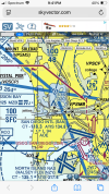
Looking at the TAC and taking these two comments together, maybe the issue wasn’t being below 1000 ft but was being in the Class B without a clearance. If you were “over Mission Bay”, it sure looks like you were within the Class B part that goes down to the surface.

IMG_7737.png
 
I received a letter from the FAA recently proposing a 1-year certificate suspension due to a couple of holds over sea level populated areas where my ADS-B reported altitudes as low as 800'. I was told by ATC to hold at 1000' or below, and I was holding 1000' exactly. Of course I was shocked to receive this letter and I started testing out my ADS-B in flight to compare to my altimeter. On the ground, the ADS-B reported 100' low and once in the air in a level hold it would read as much as 300' lower than my altimeter. I recorded this on video and submitted it to the FAA. Their response was that if my ADS-B was that far off from my Mode C, they would have received a PAPR alert at the local FSDO and would have contacted me. Is this true?
§ 91.3 Responsibility and authority of the pilot in command.
(a) The pilot in command of an aircraft is directly responsible for, and is the final authority as to, the operation of that aircraft.
 
No one else has suggested it yet, so I will … review PBOR.

the encoded altimeter reading and the ADS-B data are separate data fields/blocks since ADS-B can’t be used for separation services.
Do you mean can’t be used for vertical separation? Because isn’t that the whole purpose of ADS-B? To use for separation as an ( better) alternative to radar?
 
Last edited:
Noe one else has suggested it yet, so I will … review PBOR.


Do you mean can’t be used for vertical separation? Because isn’t that the whole purpose of ADS-B? To use for separation as an ( better) alternative to radar?

My understanding is that ATC use of ADS-B is conditional, and in this thread, I don’t think enough information exists to determine if those conditions have been met.

I probably should have more clearly stated that.
 
Noe one else has suggested it yet, so I will … review PBOR.


Do you mean can’t be used for vertical separation? Because isn’t that the whole purpose of ADS-B? To use for separation as an ( better) alternative to radar?

since VFR flights are not required to talk to ATC, and by FAR, there is no required separation other than 'don't hit each other' and 'be safe'.

Also ADS-B OUT is not required UNLESS you operate in ADS-B required areas. My home field is in a non-ADS-B required area. Basically if you stay under 10000ft MSL and don't go in/over class B/C or a mode C vial you don't need it.
 
Last edited:
Looking at the TAC and taking these two comments together, maybe the issue wasn’t being below 1000 ft but was being in the Class B without a clearance. If you were “over Mission Bay”, it sure looks like you were within the Class B part that goes down to the surface.

View attachment 141516
Depends on where Mission Bay. There is an intersection of Class B boundaries right over the VOR. To the south is the SAN surface, but to the north are 1800' and 4800' floors. And that's assuming no Class B clearance.

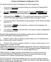
Besides, if, as stated, they received a Notice of Proposed Certificate Action, it specified exactly which reg(s) the FAA claims was violated. and how they were violated. For illustration, this is a sample content of a simple NPCA claiming a common IFR altitude violation. (yes, from a real case). Point is, a claimed violation of the minimum altitude rules will cite the minimum altitude regs; a claimed violation of Class B will cite the regulation requiring a Class B clearance.

1748714676270.png
 
Depends on where Mission Bay. There is an intersection of Class B boundaries right over the VOR. To the south is the SAN surface, but to the north are 1800' and 4800' floors. And that's assuming no Class B clearance.

Besides, if, as stated, they received a Notice of Proposed Certificate Action, it specified exactly which reg(s) the FAA claims was violated. and how they were violated. For illustration, this is a sample content of a simple NPCA claiming a common IFR altitude violation. (yes, from a real case). Point is, a claimed violation of the minimum altitude rules will cite the minimum altitude regs; a claimed violation of Class B will cite the regulation requiring a Class B clearance.

View attachment 141535

The only thing that's clear to me about this story is that there's more to it. On its face, the charitable interpretation of the OP's defense to a 91.119 violation is that he was actually only violating 91.123. But without knowing what happened leading up to and after the alleged violation, it's really hard to grok.
 
:yeahthat:

Oh, if only Paul Harvey were still alive....

It would certainly be helpful if the OP would post the letter, redacted as necessary. Otherwise, this is starting to seem rather like trolling.
Helpful to us, not necessarily to the OP.
 
Depends on where Mission Bay. There is an intersection of Class B boundaries right over the VOR. To the south is the SAN surface, but to the north are 1800' and 4800' floors. And that's assuming no Class B clearance.

Besides, if, as stated, they received a Notice of Proposed Certificate Action, it specified exactly which reg(s) the FAA claims was violated. and how they were violated. For illustration, this is a sample content of a simple NPCA claiming a common IFR altitude violation. (yes, from a real case). Point is, a claimed violation of the minimum altitude rules will cite the minimum altitude regs; a claimed violation of Class B will cite the regulation requiring a Class B clearance.

View attachment 141535
Where and when was there an FL170 in the USA?
 
Not me. But unless that’s a helicopter he sure is busting. Even ADSB error can’t excuse that one. Most of my hold was over the water but I was over the land section a few times. It was at least a 10 minute hold.

That letter posted above is really enlightening. I imagine the only reason it was a proposed certificate action was because they came within close proximity of another aircraft. I would think otherwise they would have gone through the compliance program or whatever it’s called.
 
Personally, I would not file a NASA report. It's way after the alleged transgression and after the FAA has initiated action. "anything you say can and will be used against you"

But he didn't know about a possible violation until he got the letter.
 
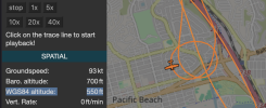
Things have a funny way of unfolding. I just received a quarterly newsletter email from ADSB Exchange. Probably many of you here just got the same thing. One of the topics is the new barometric altitude correction feature. I figured out how to activate the field, looked up the barometric pressure for the date/time of the flight, plugged it in (30.13), and suddenly my altitude is just over 1000' for the entire hold. Boom. How can the FAA deny that?

Am I on the right track here? Missing anything? Just made my day.. unless somebody here is going to burst it.
According to the sectional posted above the ground (the land section) is 250’. The island in Mission Bay is 320’.
 
Not me. But unless that’s a helicopter he sure is busting. Even ADSB error can’t excuse that one. Most of my hold was over the water but I was over the land section a few times. It was at least a 10 minute hold.
Oops, guess it must have been the other photo flight aircraft that busted altitude over Mission Bay exactly a year ago, and is also owned by Troy Hartman: https://globe.adsbexchange.com/?ica...owTrace=2024-05-29&leg=1&timestamp=1717005871

As to why the FAA cares: if you scroll through the history you'll find 10 other altitude busts in 6 months.
 
According to the sectional posted above the ground (the land section) is 250’. The island in Mission Bay is 320’.

The Sea World tower is 320' and over 2000' away. The 250' land section is on the other side of the freeway. On the west side it's an RV park at sea level.
 
Back
Top