radioguy01
Pre-Flight
- Joined
- Jan 12, 2014
- Messages
- 46
- Display Name
Display name:
radioguy01
Hi all,
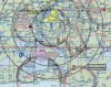
This is a screen capture of a nearby airport (KLCH). It's class D airspace.
I have a few questions:
1. Class D airspace - in all the textbooks they show it as a straight up and down column of space, but on the map, it appears to have that "inverted cone" appearance that they show class B airspace having. I can clearly see the expanding concentric rings with different bottom altitudes. Does the column shape the textbooks show mean anything?
2. I can see the VOR off to the east of the airport. I don't know why, but it strikes me as odd that an airport doesn't have a VOR itself. How wonderful would it be to just tune to an airports VOR and fly right to it. Now, I haven't really done the VOR navigating part of my training yet. But, it would seem that you would just draw a radial out from the VOR, and then tune your OBS to that radial (something like 170') and "fly to it." But how would you do this if you were completely lost? Lets say you had autopilot on, no GPS, and you blacked out for 20 minutes. (I know, that's stupid.) So you wake up, assume you're somewhere near KLCH, and you tune that VOR that you know is east of the airport. You tune the radial that should bring you right over the airport. Would you just fly until the "TO" changed to "FROM" (or vice versa), which would tell you that you passed over the VOR tower, and then turn around and look for the airport? (Or would you tune the airport and ask them to vector you in?)
3. If you look at the bottom of the picture, the dark colored rings. Is that denoting a column of class E airspace? If so, why are those areas class E? I don't see anything in them other than a couple of towers and lakes. And does that mean anything outside of the D and the little shaded rings of E is class G airspace?
4. I think this is a great example of how cluttered these maps are. It took me several minutes to realize the VOR information for the VOR east of KLCH is actually up above and to the left of the whole area, well out of the way (it's not even pictured on this screen capture.) They definitely should have obstacles, private airports, etc, all on different "layers" that smart software (ForeFlight, Garmin Pilot, etc) can switch on and off to get the detail you want.
")