Just thought of a an addition to the vanity N-number thread....
Eight-Three Victor Oscar.
Stylize the 8 to look like a "B" and the 3 to look like a backwards "E"
Why??? Read on:
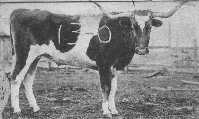
How t.u. got a longhorn as their mascot and how it became known as BEVO
Origins:
Bevo, the longhorn steer mascot of
the University of Texas t.u., made his debut on Thanksgiving Day, 1916. During halftime of the annual rivalry game against Texas A&M, a group of Texas supporters led by Stephen Pinckney presented the the steer to the Texas student body. Pickney, who had graduated several years before and had long sought to give his alma mater a live longhorn mascot, found the steer while assisting in some West Texas cattle raids. Pickney gathered up contributions from 124 fellow alumni and shipped the steer by rail to campus just before Thanksgiving. It arrived on gameday.
Mascot BBQ:
Texas beat the Aggies, 22-7. But the new mascot didn’t seem too happy about it. Possibly because he was shipped to Austin without any food or water, Bevo was in a foul mood and even charged a photographer trying take his portrait.
Things got worse a few months later, when Aggie fans snuck into Austin and branded Bevo with a “13-0” -- the score of a recent A&M win over Texas. Bevo was soon afterward shipped to a ranch outside of Austin. He remained there until 1920, when the University tired of paying 50 cents a day to keep him fed. So the original Bevo ended up being served, as dinner, at that year's football banquet.
The Bevo Myth:
Texas legend states that the name "Bevo" originated from the Aggie's “13-0” brand. According to this popular story, when Texas undergrads discovered the brand, they tried their best to alter it, turning the "13" into a B, the hypen into an "E", adding a "V", and keeping the zero, thus making the score into the name “Bevo.”