You are using an out of date browser. It may not display this or other websites correctly.
You should upgrade or use an alternative browser.
You should upgrade or use an alternative browser.
2nd GPS approach Q tonight
- Thread starter Let'sgoflying!
- Start date
luvflyin
Touchdown! Greaser!
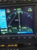
The plate (same apprch as in 1st Q) offers an LPV.
Why does the 530W display “LNAV” (bottom L)?
Shouldnt it say “LPV”?
The approach is selected & activated.
I think it might be because you aren’t yet to a point where it’s been programmed to think you can successfully complete an Approach to LPV minimums. Maybe because you’re not close enough to RUWEL yet, or maybe not at an altitude that’s close enough to the Glidepath.
- Joined
- Dec 5, 2010
- Messages
- 5,144
- Display Name
Display name:
GeorgeC
Maybe it downgraded to LNAV due to loss of integrity?
https://www.pilotsofamerica.com/community/threads/do-i-have-the-required-equipment-for-lpv.98117/
https://www.pilotsofamerica.com/community/threads/do-i-have-the-required-equipment-for-lpv.98117/
midlifeflyer
Touchdown! Greaser!
- Joined
- May 25, 2006
- Messages
- 17,195
- Display Name
Display name:
Fly
When was it? Were there any GPS NOTAMS?
luvflyin
Touchdown! Greaser!
It won't go to LPV until the FAF is the active waypoint.
RUWEL, the FAF, was the active waypoint. He was 3.48 miles from it. Seems to me I remember there was some 'capture box' so to speak, you had to be in before it would annuciate LPV. If so, is it less than 3.48 miles?
Last edited:
midlifeflyer
Touchdown! Greaser!
- Joined
- May 25, 2006
- Messages
- 17,195
- Display Name
Display name:
Fly
You may be onto something. The snapshot of the box doesn't tell us everything, altitudes and groundspeeds ferinstance. For example, if this is the straight-in from FST scenario and the altitude limits are being followed, at 193 kts GS, that's about an 1800 FPM descent rate between TIFE and RUWEL. The I don't know whether the unit is smart enough to say, "no way you're in position to do an LPV"?RUWEL, the FAF, was the active waypoint. He was 3.48 miles from it. Seems to me I remember there was some 'capture box' so to speak, you had to be in before it would annuciate LPV. If so, is it less than 3.48 miles?
aterpster
En-Route
- Joined
- Apr 15, 2011
- Messages
- 3,317
- Display Name
Display name:
aterpster
It won't start ramping down ILS-like until 2 miles from the FAF. There are offset limits that will cause the navigator not to switch from terminal to approach. But, those are way off centerline and at acute angles. I don't know the specs; that's not pilot stuff.RUWEL, the FAF, was the active waypoint. He was 3.48 miles from it. Seems to me I remember there was some 'capture box' so to speak, you had to be in before it would annuciate LPV. If so, is it less than 3.48 miles?
luvflyin
Touchdown! Greaser!
You may be onto something. The snapshot of the box doesn't tell us everything, altitudes and groundspeeds ferinstance. For example, if this is the straight-in from FST scenario and the altitude limits are being followed, at 193 kts GS, that's about an 1800 FPM descent rate between TIFE and RUWEL. The I don't know whether the unit is smart enough to say, "no way you're in position to do an LPV"?
It does evaluate vertically. This from the Garmin Pilot Guide:
5. Sixty seconds prior to reaching the FAF (LOTKE), the unit will check the required Horizontal Alarm Limit (HAL) and Vertical Alarm Limit (VAL) to ensure the GPS position integrity is within limits to complete the LPV precision approach. In the event the HAL or VAL limits are exceeded, the approach will be downgraded to a non-precision approach indicated by “LNAV” on the moving map, a message that the approach is downgraded (“Approach downgraded - Use LNAV minima”), and the glideslope indicator will be flagged. You may continue the approach using LNAV non-precision minimums if there are LNAV minimums for this approach. In the rare event the GPS integrity cannot meet the non-precision HAL limits, the unit will send a message to the pilot to abort the approach (“Abort Approach - Loss of Navigation”). The unit will revert to terminal limits to support navigation to the missed approach when the message is acknowledged. After the aircraft has passed the FAF, a loss of WAAS integrity will cause the approach to abort instead of downgrade.