18 days in paradise and a Masters Degree in Bahama Out Island Exploration w/ HD video

beestforwardspeed

Pre-takeoff checklist
Joined
Apr 26, 2013
Messages
289
Display Name

Display name:
CoopAir
If you liked my trip report from my vacation to the Bahamas in 2012 and my travelogue from Subarctic Quebec last year, you will LOVE what is about to come your way shortly!!

After considerable blood, sweat and tears, I have FINALLY reached the next level of Bahama Out Island Exploration and lived to tell about it!!

As hard as that was though, the real work came after I returned home, spending dozens of hours editing video, and stills to publish for all of you to enjoy!!

But before I get into the meat and potatoes of this travelogue, I want to give you a preview of what you can look forward to in the coming days and weeks and I document the obstacles, challenges, rewards, and tense moments visiting what is by far my most favorite destination on the entire globe.

Just a few of the many highlights that you will be along for:


1) A little known, but absolutely beautiful place where almost no one ever goes when they rent a boat from Staniel Cay!


2) The geologic cousin of the Exuma Chain. While everyone and their brother has been to the Exuma's, this place on the other hand, recieves less than 1% of the visitors that the Exuma's get.

3) A forgotten collection of sandbars in Eleuthera that are unknown to most who visit that island

4) My attempt at a 7 mile walk each way along the beach on a very remote out island. This beach is so seldom visited that there were literally no known photos, video, or travel accounts posted anywhere on the entire internet of this place!!


5) Plus MUCH MUCH More!!
 
Re: 18 days in paradise and a Masters Degree in Bahama Out Island Exploration w/ HD v

PART 1: Video from July 10th and 11th:
https://vimeo.com/103085320


Stills from July 10th: https://www.flickr.com/photos/56841718@N06/sets/72157647182815641/


July 10th:

Woke up at 4:15 AM today to make sure that I can preflight and be wheels up right at 5 AM, just as it would get light enough to video the entire flight down to paradise!

My hopeful plan was to be able to fly straight through to MYBG today with 3 fuel stops in PHF, MYR and then FPR where I would also pick up the raft to rent

To make it to MYBG in one day, I would absolutely have to be on the ground there no later that sunset (00:05Z) and would want at least a 20 min cushion.

At 5:04 AM, I depart runway 20 at HFD and fly south along the CT shore, then right over JFK. The wx VFR up until the Deleware Bay where I have to deviate around some cells. At first it looks as if I will have to turn 45 deg right of course to a 260 HDG to get around the cells. I can see about a 10 mile gap on my XM in the cluster, but being in solid IMC, I just don't feel safe trying to pick my way in between.

At that point, I ask for a climb from 4 to 6 thinking that I MIGHT be able to get into VMC, but figure it likely won't make a lot of difference.

Much to my total surprise, I get on top of everything except the TCU's and CB's at 5500 and can now visually see the gap that is being displayed on my XM. I ask ATC for a 180 HDG (give or take) and tell them that I can see a good size gap on that HDG.

They approve this and I pass in between the 2 cells with good visibility and a very smooth ride! Shortly after, I have to deviate to about a 250 HDG again for about 15 nm to get around the end of another line, hardly adding a lot of time on a nearly 1200 nm trip!

I am amazed that there is such widespread IMC in July in the Mid-Atlantic region with a front stalled out near the Delmarva---a rare occurance for the height of summer.

Comanchepilot can correct me if I'm wrong, but I think we never got out of the persistent trough that gripped most of the east coat during much of last winter!!!!

The landing at PHF comes as a surprise with 700 OVC being reported on the ATIS! I am vectored for the ILS 25 and break out at 600' and taxi over to the ramp to refuel.

To minimize travel time, I don't even stop to eat, but rather bring several bags of trailmix to munch on as I'm flying down. Luckily this plane has an excellent 2 axis AP on its G1000 which makes a big difference when it comes to preserving my mental energy on a 13 hour trip!

After departing PHF, the weather steadily becomes VFR as I make my way over central NC! Unreal to have flyable IMC that far south in July!! That global warming sure is bringing these fronts further and further south
rolleyes.gif
rolleyes.gif


Coming up on MYR, I am given the visual to 18 and land uneventfully and top her off at the self serve pump and then depart rwy 18 on course to FPR.

The plan before was to fly non-stop from MYR-FPR, but having some convection along the Fla coast until about 50 miles before FPR made me want to land short in SSI and top her off.

This cost me about 20 minutes, so making it to MYBG was questionable at this point with plan B spending the night in FPR and then flying the remaining 170 NM at 6 AM the next day.

The t-storms along the Fla coast were pretty menacing but easy to avoid with the Mark I eyeball. I think I only had to deviate 10 deg to the left, if that.

In hindsight I could have made it without refueling, but why raise my blood pressure when its supposed to be a fun trip.

After arriving at FPR I called customs at MYBG and asked them if they could wait for me as I would be landing at 7:30 with more than a half hour to spare. THey said that was fine, but would cost an extra $50 in overtime fees after 6:30 PM. No problem, still less than what I'd pay for a room at FPR.

I touch down at 7:32 and make my way into customs where I was rushed through! They had to close up at 8:00 (which I did not know at the time) and then I got a ride to the Harbor Inn, located about 500 ft from the pool bar and literally across the street from the dock where my rental boat (18' Outrage) would be waiting for me the next day.
 
Re: 18 days in paradise and a Masters Degree in Bahama Out Island Exploration w/ HD v

JULY 11th pics:
https://www.flickr.com/photos/56841718@N06/sets/72157647143597206/


For video from today, click on the Vimeo link at the top of this post (it covers both July 10th and 11th)


I woke up at 8 AM to get ready to take the boat out to a very nice sandbar, about 10 nm south of MYBG.

I accidentally discovered this sandbar back in June of 2012 when flying from Nassau to FPR. Even at 10,000 ft, it just jumped out at me as being so stunning as a lone white strip, surrounded by blue water. When I saw this, I knew I would have to visit it on a future trip!

After loading my container full of Explorer Nautical Charts and gadgets on the boat, I exit the harbor and turn SW and then S. With about 2 ft seas, the ocean is rougher than I thought it would be and I get splashed a bit, which I was not happy about since I had my non protected camera around my neck!!

I quickly stowed it and stuck with my waterproof Gopro for filming!
The ride down there was uneventful, although being the first time as PIC of a boat in almost 2 years, I felt noticeably rusty and unable to achieve a mode of total relaxation despite beautiful blue skies that match the water color perfectly. Why so many idiots think they can safety pilot one of these things drunk is beyond me.....

That being said, what you might have heard about the Outrage is all true!! Very stable, forgiving, and slices very gracefully through the chop. Doing in the low 20's knots was no problem, even into head seas.
At around 10:45, I arrive to the sandbar as the tide is going out, now halfway to LT. Because of this, I make sure to anchor is deeper than usual water.

I get out and walk/swim the remaining 100 ft to the sandbar and climb up, happier than a 2nd grader waking up on his B-day opening presents!! I spend the next several hours getting pics and video of this wonderful place.

In the early afternoon, I am looking to the south and notice a few t-storms, about 10 nm away. Much to my surprise, I can hear occasional thunder as I had thought that they'd be too far to hear it. Its At that point I am ready to get out of there if they start moving towards me.
The one thing I had forgot to do before I left was check the winds aloft at the 18,000 ft level to figure out what direction theyd be moving!
Luckily I have my satellite phone with me, so I whip it out and call my CFII who checks for me on ADDS.

Luckily, he tells me that they are moving from about 110 deg so that being the case, the cells will move parallel to me, not towards. Yipee!!
Because I was a bit lazy, and knowing the tide would rise before I head back around 5 PM, I go over to the boat and realize that she is only in about a foot of water now.

OOPS!! Can't go anywhere till the tide comes up. Not really worried, just wish I had taken 5 minutes to move it to deeper water 90 min ago! During the peak of LT, there is a secondary sandbar, just 50 ft from the main one that comes up a few inches above the water.

LT where I am is actually 90 min later than what is published for Nassau, (the Explorer Charts were spot on mentioning this) so its not until 2:30 that it starts to rise again, and its not until 4:15 that I have deep enough water to get out of there.

Now time to leave, I start by going west, and then north back to GHC, I get her up to about 25 kts on plane once in about 4-5 ft of water. The ride back is uneventful and I pull into the narrow harbor entrance at 4:45 and have her tied up at 5:00.

That evening I get a ride down to the restaurant by the airport and then eat dinner at the pool bar. I was having so much fun all day, that I neglected to eat anything until dinner time-----something that will become a common theme as I go on the Bahamas diet.
What is the Bahamas Diet?

One meal a day, skip the other two because you are having way too much fun to think about food until dinner!!
 
Re: 18 days in paradise and a Masters Degree in Bahama Out Island Exploration w/ HD v

Video from July 12th and 13th: https://vimeo.com/104542294

July 12th and 13th pics: https://www.flickr.com/photos/56841718@N06/sets/72157647301416251/

Saturday July 12th:

Woke up today and started gathering all my stuff (I packed wayyy too much crap!) which took at least an hour and then loaded it all into the jeep to drive from the marina to the airport, where I will be flying to Staniel Cay and staying there for 2 nights.

Unfortunately, upon arriving at the airport, the immigration officials are a bit mad at me because I had parked my plane towards the front of the ramp where there is a lot of traffic and prop blast. With the plane only being chalked down, I noticed that it had moved slightly from where it should have been when I arrived on Thu night.

I think I was more upset than the officials were, thinking how bad it would have been if it had been damaged, leaving me stranded!! I was kind of puzzled that they had a problem with me parking it there, because they didn't ask me to move her when I arrived 2 days earlier.

Oh well....next time I'll park in the back!!

Before too long, after setting up my multiple Gopro's, I depart runway 13 and then fly along the pristine and deserted beach on the east side of Haines Cay, just across a creek from the main island of GHC.

14952729440_50b9655a1b.jpg


15136418451_3750153011.jpg


After that, I fly over the sandbar that I visited yesterday and then make my way to the start of the Exuma Chain where I flew at 500 ft to get more pics and video. This never gets old. The color of that water has got to be some of the most beautiful and clear ocean anywhere in the world!! A sight to see!

I make a straight in approach and landing to runway 16 at Staniel Cay (MYES), where I change the batteries in all of my Gopro Cameras.

The plan now it to fly again 35 nm on about a 260 HDG to the Scrub Cays, a string of sandbars and other low lying sandy cays that stretch for over 20 nm, almost to Andros.

The reason that I am doing this is because, tomorrow I will be renting a boat from Captain Wayde (a 17' Skiff) and taking her out to the the Scrub Cays if the weather cooperates.

Because the Explorer Chart books have very sketchy into and few soundings of the area around the Scrub Cays, I had planned long before the trip to do the overflight as close to low tide as practical, and then take the boat there as close to high tide as I could. This way, I could mark the track on my GPS in the plane, and know that anything that is covered in water, has AT LEAST 2-3 feet of water over it when I return on the boat near HT.

Not to mention it'd be a lot easier on the plane to scope out the most beautiful sandbars without wasting precious time on the boat the next day!

At around 4:15 that afternoon, about 1 hr past LT, a depart MYES, and turn on course to the Scrub Cays.

I fly at around 300 ft most of the way, and occasionally dip down as low as 50 ft to get an idea with how high the seas are for a given wind speed. Flying a G1000 gives me the luxury of getting a live wind speed readout.

While not on the surface (of course!!) I'm sure the winds are not a lot different at 50 ft than they are on the water.

When flying this low, there are four rules I follow to a T, no exceptions:

1) Never any passengers onboard

2) Tune in 121.5 on active

3) Over an unpopulated area only

4) Trim the plane nose UP so if I let go of controls (accidentally) she will climb!

Sure, even doing all this, it is less safe than flying at altitude, but I do what I reasonably can to mitigate this risk, not eliminate it. Heck........if I really wanted to play it safe, I'd have just bought an airline ticket here and left all the flying to a crew of two with a combine experience of 5000 hrs or more!!

So back to what I was saying.........

About 22 nm west of Staniel Cay, I come upon the first exposed sandbar in the chain. Ahead, I can see dozens more, and further up, bores that are substantial enough to support vegetation. Some are nicer than others, but I know I will have my pickin' for which will be the best to visit tomorrow on the boat.

14952837517_aab76fef2d.jpg


14952724660_f22cbbb834.jpg


15139009342_2afd888fa9.jpg


About 20nm E of Andros, I turn back and get some more film---this time with the sun at a better angle behind me which of course means better pics and video.

I make an uneventful landing back at MYES and then meet Nikki Ferguson at the airport to get a cottage for the next 2 nights. I opt for the least expensive Sabach, and while decent and clean, next time I'll probably pay $50 more for one of her nicer kept ones. NABD in the grand scheme of things since I'm spending so little time in my room anyway:)

I meet up with Capt Wayde that evening and start to load up the boat to save time tomorrow. He verifies that the tank is full and that she starts up without difficulty. All is well with her. I have 35 gal in the main tank, plus 5 extra in the spare, more than enough for the roundtrip.

I skip drinking anything alcoholic that night because taking a 17' Skiff on a 60nm roundtrip adventure to a very remote and rarely traveled area as a 1 man band will require a very clear head!!

At 10 that night, I check the weather one last time. On www.windfinder.com, they are forecasting winds from the ESE at 11-13 kts for most of the day, a bit on the breezy side, but nothing that should cause any issues.

Off to bed I go.....
 
Re: 18 days in paradise and a Masters Degree in Bahama Out Island Exploration w/ HD v

Coming up next:

A sandbar, over 20 nm from civilization, that is more beautiful than even the best IMC I have ever flown in??

Is that even possible??
:confused::confused:

Stay tuned to find out!
 
Last edited:
Re: 18 days in paradise and a Masters Degree in Bahama Out Island Exploration w/ HD v

Sun July 13th:

A sandbar more beautiful than the best IMC I have EVER flown in?? Is that even possible??

Read on..

I gather all my supplies to take on the boat where I will be off into the wild blue yonder, bound for the Scrub Cays.

These cays are sooo far off the beaten path that almost no one ever goes there!

David Hocher, the owner of SCYC told me that he has not even visited this place yet, even though he has been running the SCYC for well over a decade!!

If thats not a litmus test, I dunno what it :)

I drag myself out of bed a bit later than I had planned and pull out of the dock at 9:40, on course to about a 260 hdg. It is an absolutely GORGEOUS day with not a cloud in the sky.

About 5 nm out, the ocean seems a lot rougher than what I would have thought which gives me pause. Being that its a following sea, its not a problem now, but its something that I make sure to monitor since it will be in a head sea on the way home.

I am cruising at about 20 kts at around 3200 RPM, moving along nicely. About 11 nm out, almost halfway there, I momentarily turn back to the east towards Staniel Cay to see what the ride going back is going to be like into the head sea.

10 kts and 2600 RPM (give or take) is all that I can manage comfortably with what I estimate to be 3 to occasionally 4 ft head seas!
At that point, after some mental fuel burn calculations, I know that I am logistically prepared to make it to the Scrub Cays and back.

BUT.................

I ask myself, "Even though I am logistically prepared for the return leg, am I MENTALLY prepared to deal with punishing head seas for over 3 whole hours?"

"HELL YEA", I tell myself! It'll be sooo worth it to visit some of the most beautiful scenery on the entire planet!!

I continue on course to "paradise within paradise". About 5 nm later, the water turns the perfect shade of blue with a nice sandy bottom. I estimate that it is around 6 ft deep, but much to my surprise, it is 10 ft when I stick my depth gauge underwater.

About 10 minutes later, now about 1 hr after high tide, I can see the first sandbar come into view, soon followed by many more of the string, further to the west. As luck would have it, the first sandbar looks the most picturesque so I aim for it and then slow up as I get her in closer.

Since it is just past HT, I am extra cautious (paranoid) to bring the boat anywhere in even marginally shallow water. If I had someone else with me, (especially someone big and strong) Id take her in closer, but as a 1 man band, I don't want the stress of having to watch her every 10 minutes on a falling tide.

I end up really playing it safe and anchor in 3-4 ft of water, about 50 yards from the sandbar. She only has a stern anchor, which is better than nothing, but I much prefer to anchor her from the bow. Not the end of the world as she'll be in sight the whole time.

As I walk/swim to the sandbar, its beauty hits me full force!! I mean....its the perfect shade of white surrounded by amazing blue water as far as the eye can see! Something straight out of a movie!!!

https://farm4.staticflickr.com/3924/15138350361_3ff
516b8df.jpg

Even the most fantastic scenery I have experienced in all of my IMC reports that I post, fell short of the raw beauty of this absolute gem of a gem. Heck, even 200 and 1/2 with crisp tops to 5970 with the sun setting couldn't quite measure up to the beauty of this sandbar----and as anyone who knows how much I love IMC......that tells ya something!!!

15118318906_ff392e8ae8.jpg


I have a momentary somber pause and am reminded of the Haitian refugee boat that ran aground in this area last year, with many eventually dying from exposure and dehydration of course. Its a cruel irony to be reminded that such a beautiful place could also be so unforgiving and deadly to the unprepared.

I spend some time there (don't know if it was 15 min or 45---time just stands still when you are cutoff from the real world like that)!

After soaking in this piece of heaven on earth, I get back to the boat, and take her another 4 miles further west down the chain to a more substantial sand bore. This one has enough of a foundation to support vegetation in the form of pine trees.

14954630389_1fa17930b1.jpg


While not as nice as the previous one, it still holds it own in the scenery department. Not to sounds like a downer, but what would make this one even better is if one could somehow manage to plant a substantial and fairly dense grove of coconut trees.

Not being an expert when it comes to soil and gardening, I don't know if this particular sandbore/cay could support coconut growth, but its interesting to ponder the thought anyway. Something as shown in the pic below is what I envision.

cwe6784.jpg

Because of the head seas that I am sure to face on the return, I set a FIRM turn-back time of 2:00, not a minute later. As luck would have it, I am ready to go 10 minutes early and brace myself for what is sure to be a punishing, long and wet 30 nm haul back to SC.

The first 5 miles aren't half bad, but I know that once past the last sandbar, that the fetch will increase making for a rougher ride.
Sure enough, about 6 nm into it with still 23 more to go, I am getting soaked in the trough of every wave.

If that isn't bad enough, my sunglasses are almost useless with the salt stains on them. Just as predicted, I am able to achieve about 10 kts, but not much more.

About 3 nm later, I come upon a relatively shallow (5-6' probably) bank with isolated to scattered coral heads here and there.

14954670940_bda9d96439.jpg


Even though they are not charted, they are certainly something that I want to steer around, and luckily with a cloudless sky and the sun almost vertical and slightly behind me, I have excellent lighting and can easily avoid them using visual piloting rules (VPR).

As shown in the photo above, its never easy to tell if coral heads like this one are 3 ft under or just 1, hence why I assume that they are all a navigational hazard and steer clear of them.

This goes on for about another 3 nm until it becomes just a sandy bank in the 10-15 ft range.

Now I am about 20 nm from SC, making slow progress in what I estimate to be 3-4' seas. I continue to get soaked and brace myself for 2 more hours of this! To add insult to injury, the strap for my Gopro that I mounted above the center console, has broken off due to the relentless up and down pounding, falling on the floor behind me!

Luckily nothing is broken other than the strap so I just use the pole to film instead. As rough and tiring as the ride back is, I never feel that my safety is in jeopardy. Just like airplanes and turbulence, I'm sure these boats are built to take a hell of a lot more pounding that its occupants can endure!!

By the time I am 15 nm out, about halfway there, the get-home-itis factor has kicked into overdrive. I am now at the point where every mile feels like 10 as they slowly count down on the GPS in a torturous fashion!
Being no stranger to extreme outdoor activities, I can unequivocally tell you that the few hours of pounding I am enduring on this 30+ nm return is taking MUCH more of a toll on me mentally and physically than did camping in Upstate NY in January when the temperature dropped to -25F

14996865670_ca0ef59574_n.jpg


Not only that, but this is even taking up a lot more "mental bandwidth" than a 400 nm flight with in hard IMC with ceilings near minimums along the entire route, without an AP, in solid moderate turb!

Moving along, next thing I know, I am 10.5 nm from SCYC with no sign of the seas showing any mercy on on my hapless soul. At that moment, my brain tries to grab hold of anything to convince me thats its not as bad as it is, if that makes any sense. In response to this, just a split second later, I look forward to the GPS going from 10.0 to 9.99 nm in about 3 minutes time at the speed I'm going!!

Ahhhhhh.........The relief I feel once I see the GPS go from 10.0 to 9.99 nm distance remaining!!

Even though its just a number that the unforgiving ocean doesn't give a crap about, it feels as if I have cleared a significant hurdle towards comfort! Kind of like getting 10 inches of snow on the first day of spring, but knowing that winter will lose its grip sometime in the near future.
Sure enough 9.5...........9.............8.5..............8 nm out, and the sea is still giving me 3 to 4 ft swells in very short intervals. Surely, once I near the Exuma Chain again, this will improve.

But how many more miles of this will I have to take?

Anyone's guess.............

Light at the end of the tunnel appears when I am about 5 nm from shore. It seems as if the seas have gone from 3-4' to now 2-3 ft. I'm about to pick it up a few kts, but I am still far from being able to enjoy the ride.
4.5..............4.............3.5................3 nm.

Now I finally can start to relax as I am dealing with seas no more than 2 ft.

Whooooooo!! Hallelujah!!!!!!

Now its right at 5:00 and I'm just 1 nm out. Finally, I can resume my normal speed and a few minutes later, I pull her up to the fuel pump at the YC dock and am very curious as to what I burned.

(continued on next post)
 
Last edited:
Re: 18 days in paradise and a Masters Degree in Bahama Out Island Exploration w/ HD v

(Picking up where I left off)

I top off the tank and see that it took 23 gallons to get her full as when I left that morning. Thats turns out to be exactly 2.6 nmpg, a bit more that I'd have thought, but still at least a 2 hour reserve.

As I bring her back to the dock where I took her, a close friend of Capt Wayde tells me that the tank was 25 gal, not 35!!

YIKES!!

My heart sinks, realizing that if that is true, I came back with just 2 gal in the main and 5 gal in a spare jerry can. Much less than what I deem safe!!
In the months leading up to my trip, Capt Wayde consistently told me it was a 35 gal tank in at least three separate phone conversations when I asked him just to be sure.

I believe Wayde over the other guy because not only did he consistently give me the same figure three different times, but I also gave the tank a push when I returned to see how light it felt.

When I did that, It did not move easily. In fact, it did not move at all. Something tells me that if it really did have just 12 pounds remaining, that it would be very easy to slide around.

Still a needless scare:mad2:

Even though I am generally not one for more govt regulation, it ought to be a legal requirement to placard in plain sight the fuel capacity, just like in aircraft!!

That night at the bar, I enjoy myself over some nice beer and mixed drinks, VERY happy that I made it to the Scrub Cays and back totally under my own power, without incident!

Tomorrow its off to Eleuthera where the following day (July 15th) i'll be renting another boat to explore another picturesque area that few people visit---albeit more than the Scrub Cays though.......

Time to examine my eyelids once again.......
 
Re: 18 days in paradise and a Masters Degree in Bahama Out Island Exploration w/ HD v

Thanks for this! A lot of effort putting it together!
 
Re: 18 days in paradise and a Masters Degree in Bahama Out Island Exploration w/ HD v

Thanks for this! A lot of effort putting it together!

Anytime!

The best of it is yet to come! Still 14 more days to post, so stay tuned:D
 
Re: 18 days in paradise and a Masters Degree in Bahama Out Island Exploration w/ HD v

July 14th video, pics and write-up: Staniel Cay to Cape Eleuthera

https://vimeo.com/104553793

https://www.flickr.com/photos/56841718@N06/sets/72157646837342570/

Woke up on Staniel Cay to the roosters crowing "c0ck a doodle doo"! I just love them crowing like that. I tried calling out back to them, but they didnt seem to respond!

The plan for today is to fly from Staniel Cay to Rock Sound, Eleuthera (MYER). Along the way, I am going to be flying low over the Schooner Cays to get some photos and video since I will be renting a boat from Trevor tomorrow to explore this area. The Schooner Cays consist of 4 islands and dozens of sandbars, located just to the north of Cape Eleuthera.

After landing I will pick up a rental car at MYER, and drive to Freetown, where I will meet Trevor. As I did in Staniel Cay, I have not made any reservations for accommodations.

Why not? Because I prefer to have the most possible flexibility in choosing which island to visit based solely on the wx that day. I figure the odds of not being able to find ANYTHING are slim to none, although the chances of not being able to find ones first choice are much greater.

I depart MYES at 1:00 and fly over Sandy Cay (3 nm to the NW) and then Twin Cays, about 2 nm past Sandy.

15141608091_77dcc7b534.jpg


14957891799_39f7192d4a.jpg


I then climb up to 3000 over the open ocean on course to the Schooner Cays. Looking ahead, I can see a significant TCU that looks like it could easily grow into a full blown CB. Even though it is menacing, like most buildups in the Bahamas, it is isolated and easy to circumnavigate visually.

15144573925_ca4979976f.jpg


Seeing that it appears to be very close to the Schooner Cays, my plan to fly over them might have to wait for another time, but I won't know until I'm a few miles away.

Luckily, the rain shafts seem to be a few nm further north than the Schooners, although it is overcast as I survey the Cays. A smooth ride too.

15141600921_16672ed6c1.jpg


Afterwards, I make a straight in approach to MYRD and land on Rwy 9. One of the line guys helps me unload the plane and puts my bags on a hand truck.

"Friendly Bob", a relative of Trevor Pinder, who I'll be renting the boat from, has arranged a rental car for me waiting at the airport. At first he told me that he would not be at the airport so I make arrangements to give the money ($70 per day) to Trevor, but as luck would have it, he shows up about 5 min before I leave so i just pay him at that point.

The drive from Rock Sound to the SW Eleuthera peninsula is gorgeous with a lot of palm trees and lush vegetation. 30 min later, I arrive in Freetown and meet up with Trevor.

I tell him that I have no place to stay and asked him if he can arrange something for me. No problem he told me as he had a room right above his shop (he repairs outboard motors, and is a darn good mechanic from what everyone tells me)!

The plan had been to take the boat out (17' Key Largo) to the Schooners from Cape Eleuthera today, but I was running behind schedule and just told him that I'd go out tomorrow afternoon. No problem he said!

Later that afternoon, Trevor tells me that he needs to head out to the airport again to get his teenage daughter, who has just returned from a 2 week school trip from Canada.

I offer to drive him out there, as I have nothing else to do and help them load her bags into the car.

Trevor is so personable and instantly makes me feel at ease with him. On the ride back, neither of us were talking much as I was pretty tired being that is was late in the day.

Normally, in a car with someone I don't know very well, that awkward silence can be uncomfortable, but not so in this case.

I commented to him that normally I would feel awkward when riding with someone I don't know well when no one is talking, but with him, it feels like I've been friends for many years and am just chilling!!

He just laughs hysterically when I mention this, and knows its so true!!

Later that evening, Trevor and I take a ride down to the Cape Eleuthera Marina and brings me to the boat and briefs me on everything.

14957887300_700ac30105.jpg


The one thing that seems to be a VERY common theme in the islands when I rent boat from locals is that before setting out, I am much more safety conscious about familiarizing myself with each make and model boat than they seem to be.

The prevailing attitude among them is that "you'll be OK......everything will work fine, no problem mahn".

I, on the other hand, seem to have the mindset of going through everything closely--but not to an obsessive level.

I don't know if that is the pilot blood inside of us, or just the way I've always been hardwired?

On the one hand, I'm glad that they trust me to use their boat as PIC, but on the other hand, I have be the master of my own destiny and speak up about anything that might not be right and ask questions about anything I'm not sure about-----kind of a double edge sword.

Once back, there is a decent restaurant just 500 ft from Trevor's place that serves fantastic fried chicken. As good as it tastes, I'm sure there was a lot of fat, sodium, etc in it. Oh well, this was my 2nd day on the "Bahamas diet" as I mentioned in my other post!

I spend the rest of the night uploading pics and video and then hit the hay around midnight.
 
Re: 18 days in paradise and a Masters Degree in Bahama Out Island Exploration w/ HD v

Enjoying the trip report here, Thanks!

We did our first trip to the Bahamas this past January (Andros, Staniel, Cat) and absolutely loved it. A close-in exotic destination that is perfect for the private pilot.

...but I keep looking for Bonefish in your vid.
 
Re: 18 days in paradise and a Masters Degree in Bahama Out Island Exploration w/ HD v

JULY 15TH, VIDEO AND MASTER LINK TO PICS:

https://vimeo.com/105021395

https://www.flickr.com/photos/56841718@N06/sets/72157646834420227/

Woke up this morning to the sound of more roosters calling out! God, I love that call!

Since low tide was not until 5:30 this evening, when the sandbars would be best, I figured I might as well take a quick flight up from Rock Sound to North Eleuthera to top off the tanks.

I depart runway 9 and then make a right turn to the south and then to the west and just like yesterday, I do some more low level flying over the Schooner Cays to get even more pics and video. Its about mid-tide and rising, so all but a few of the sandbars are still underwater.

15121818716_ac7dccb203.jpg


After doing that for about 10 min, I point her on course to MYEH, but before landing there, I fly at 500 ft along Pink Sand Beach on Harbor Island and get some fantastic video and pics!! A very nice island, but not remote enough for me:)

15141835851_f956e8bbe2.jpg


Coming into land, I practice simulated engine out and ahead of me on the approach to runway 7 is a Bahamasair Dash 8, and even though he is 30+ kts faster than me on approach, I quickly forget that there is only one turnoff from the runway, which means he has to back taxi" for about 1000 feet before clearing the runway.

Because of this, I almost have go around, but Luckily he clears the runway with about 15 seconds to spare, so i'm able to land on the first try!

I take on an additional 15 gal, not needing more since I'll be filling up in Georgetown the next day.

After a quick turn around, I head back to MYER and then drive back to Trevors place to get the boat key.

It now about 1:00. Perfect timing as the tide has been falling.

Around 2:00, I get out on the water and I set out directly for the eastern most of the 4 Schooner Cays (point E on map link below).

SCHOONER CAY MAP WITH WAYPOINTS VISITED ON BOAT:

http://mapfling.com/qsmsj6p
15252497835_6a0a3e75e1.jpg


I anchor on the north side beach (point E) and make sure to anchor her deep enough with the falling tide.

Unfortunately, the wind is not blowing exactly perpendicular to the shore, so she swings almost parallel to the beach. I should have asked for a stern anchor which really would have come in handy!!

I explore this island for a while and then make my way to the west to the next one.

Even though the straight line distance between the two is only 3000 ft, it is necessary to steer a 220 hdg to point H, then 340 from there to point I and then 050 from I to J since there is shallow sand on the direct route.

I'm sure the locals would be able to do direct, but I don't feel comfortable at all. I already have 3 things working against me making this particular trip a lot harder than it ought to be: 1) A completely overcast sky that make reading the water hard 2) An outgoing tide 3) Sketchy and inadequate survey data with few if any soundings.

Yes!!! I'll be glad to go out of the way to lower my blood pressure, thank you very much.

Now having rounded the bend at point I, I'm coming up on the west side of the 2nd Cay (point J) and am about to anchor her just to the north of that sandbar. I kill the engine and raise the motor and get ready to drop the anchor.

Next thing I know, I'm drifting south onto that sandbar with a current, and before I know it, the bow is up on the sand with the stern about to swing around!!

YIKES!!!!!!!!!!!!!!!!

I leap off the boat in my clothes (2-3 ft of water) and use every muscle to drag the boat off the sandbar and get her out to the W so she?ll drift into deeper water with the current. This works, but its too late to save my cell phone which was in my pocket and is completely ruined!! Oh well!

I am kicking myself, because for months I had known that the current flows from NE to SW when the tide goes out. I had just forgotten about it for a second and it almost cost me my ego! I was never concerned damaging the boat, and certainly not my safety, but it would have been embarrassing as hell to have to call out Trevor for a tow!!

Phewwwwwwwwwwwww!!

I move on to the next island to the W (Bottle Cay--point O) and again, am not able to go direct. At point L, i think about cutting across, but the sandbank looks shallow, so I go on further and cut over at point M, and then turn to about a 020 hdg.

Soon after, I anchor on the south side just off shore, making sure to check my drift with the engine at idle before anchoring!! No current here luckily, so I hop off and explore the shore where there is an abandoned shack with some lush palm trees around.

15144754435_e231e51e23.jpg


15144763055_94804b09bb.jpg


Then I make my way to the west side of the island and walk up on a dock. I quickly realize that there is fishing line across it, and make my way back quickly, not wanting to get snagged by that by myself in the middle of nowhere.


When I get back to the boat, I go to crank the engine and I realize she won't start. Ughhhhhhh. I try a few different things and after about 10 min of trying, I call on VHF to Cape Eleuthera Institute and tell them where I am and that I might need a tow, but to not send anyone yet.

After 5 more min of trying, she starts up fine. No idea what happened!!

After getting her running again, I make my way from point O to point S to visit the sandbar just to the west of there.

Looking to the NE, I can see a few sizable CB's and since the sandbar that I want to visit next is off to the north, I want to make sure that the cells aren't moving towards it.

14958061829_f0ca059582.jpg


I then whip out my sat phone and call the Bahamas Dept of Meteorology back in Nassau!! Luckily, the cells are moving from about 260 at around 10 kts, so I should be good to go! That sat phone rental sure is paying for itself when it comes to convenience!


As I make my way towards the sandbar (at point X), I realize that I need to be on the parallel channel, offset to the NW, to access that sandbar, so I reverse course back to the SW, and head from point S to point U. At that point, it is almost right at low tide (tide here is probably 45 min to 1 hr after Nassau) I can?t decide whether or not cut west here (in front of the Island) or on the back side of it further to the South.

I decide to slowwwwly cross over at my present position (point U) and at that point, the water seems to be getting marginally shallow. I still have about 30'' still---more than enough, but just to play it safe, I shut her off and walk her across. It gets down to about 2 feet, so I?m glad that I decided to walk it across. Luckily, its only about a quarter mile of shallow water, so once I get to point V from point U, i power her up again and turn towards on a 030 hdg up the deep channel (5-7 ft) to point X where the sandbar is waiting patiently for me!!

15121738946_3801e7dab5.jpg


Now that it is right at LT, not only do I not have to be concerned about a current any more, but I am also assured that I can gently beach the boat, knowing that the water will not fall any more!! Yipee!!!

I spend about 20 minutes exploring the sandbar looking for sand dollars. I quickly come across what looks to be one, buried just below the sand. Much to my horror, I realized that it was bird crap instead!! Ughhhhhhhhhhhhhhhh!!!!!

15121737426_678d8ef270.jpg


I quickly wash my hands as best I can in the ocean (hopefully saltwater would do a decent job!) for a few minutes and then make my way back since it is now 6:00. I want to make sure I'm back by 7:15 at least 30 min before sunset.

I go back the way I came and while passing point W, OUT OF NOWHERE, a Needlefish skims across the water at 30 mph!!!!

Holy crap!!! I am lucky enough to catch it on film, but wish I had been shooting at 60 or 120 fps, instead of 30 so I could get some good slow motion of it!!!

Once at point V again, I walk the boat to point U and then start her up on the east side of that shallow bank and then turn S back to Cape Eleuthera. The water looks to be shallow even past that point so I slow down and stick my pole down to see how deep it is. Having it overcast makes it really challenging to read the water.

Turns out that I needlessly slow down thinking its 2-3 ft deep, but it?s actually around 5 feet!! Glad that I err on the side of caution!!

The rest of the return is uneventful and in water at least 10-15 ft deep. When docking the boat I make sure to allow for the tide to rise at least 3-4 ft since its only about 1 hr after LT now. Rest of the evening is spent eating, drinking and uploading pics and video.

When talking to Trevor that evening and describing the problem I had starting the boat, he told me that the problem was almost 100% that I had the throttle slightly in gear and that it must be perfectly in neutral!!

Lesson learned!!
 
Re: 18 days in paradise and a Masters Degree in Bahama Out Island Exploration w/ HD v

July 16th: From MYER to MYEF to meet-up w/friends from NC

https://vimeo.com/104554036

Master link to all July 16th pics:


https://www.flickr.com/photos/56841718@N06/sets/72157647251699412/

Arrived at MYER around 11:30 this morning, bound for G-town, where I would be meeting up with a couple from NC for a trip back to Staniel Cay the next day.

When I arrived to the airport there were t-storms all around, which meant that I wasn't even going to preflight, much less takeoff.

Even though it was nasty, I could see blue skies in several directions, which certainly indicated that this would pass soon and I'd be on my way.
It did, but it took almost an hour. Oh well!

15144475931_c473ef5ed8.jpg


I finally depart at 1:00 on rwy 9 , and then make a right turn to the south and then back to the west to do another flyover the Schooner Cays to get more pics and video.

I wanted to get some up close shots of the marker bars flying very low at just 50 ft, but there was a boat anchored there with people, so that of course was out of the question.

Right after, I turned on course to Staniel Cay, where I would follow the chain down to Great Exuma.

About 10 miles later, towering CU's with rainshafts, so I have to deviate around them slightly. No sweat as everything was very easy to circumnavigate visually.

15147065702_ed8ff13ec4.jpg


I do a low pass over the runway at Staniel Cay and then fly along the remainder of the Exuma Chain at 500 ft, getting more pics and video.
I land uneventfully on rwy 12 at Georgetown, and then taxi to Odyssey Inside, my friends Heather and Vince are patiently waiting, and help me load all my bags in the plane.

Since we were all 3 going to be flying to Staniel tomorrow, I wanted to make sure the plane was as empty as possible.

Luckily, all my stuff fits in their car and we were on our way to get some late lunch in Georgetown at Edgewater Eddie's on the inland side of Lake Victoria.

Afterwards, we make our way back to their rental home, owned by an older British Lady who is really funny. Quite a character!!

The rest of the afternoon is spent relaxing, followed by an evening snorkel in the creek, just 50 yards from the front door.

14960798360_a509729f32.jpg


I'm not the only one who has their Gopro ready to use on this shallow water snorkel as Vince also has his set up on a custom made pole. During the swim, we see starfish and many different forms of coral.

15147460785_8105961969.jpg


15147461445_e3b2fa4dc6.jpg


15147064162_4b2f84a589.jpg


Around sunset now, there is a large CB to the NW of us, probably 10-15 nm away. That is our cue to head back inside and get out of there!!

14960896438_0366b7dd50.jpg


14960750409_256cc0329b.jpg


I spend the rest of the evening organizing my cameras. Due to the amount of raw video I need to upload, i am up until almost 2:00 that night!!
I make sure to be as quiet as possible as they are surely asleep. I was afraid that I had kept them up, but they both told me that could not hear me. Good thing!!
 
Re: 18 days in paradise and a Masters Degree in Bahama Out Island Exploration w/ HD v

Jul 17th: Day trip to Staniel Cay with Heather and Vince

https://vimeo.com/103604835


Master Link to Jul 17th pics:

https://www.flickr.com/photos/56841718@N06/sets/72157646854697608/


Waking up to nearly perfect wx (yes, that's VFR, even for me:D), we are pumped to be on our way to Staniel Cay!! We arrive at the airport around 8:30 that morning and after preflighting, I brief Heather and Vince on how to use everything. With the wind being calm, we are able to takeoff on rwy 30 (rare, esp in the summer!) and then follow the shore of Great Exuma on about a 320 hdg.

I level off at just 1000 ft and we soon pass over Sandals Emerald Bay and then several sandbars and flats, about 5 nm N of there.


Before long, we can see the exclusive Musha Cay (Where ONE night will set you back $25,000!!) as well as the famous sandbar associated with in that the 4C's tour boat frequently visits.

15147096892_07775b53cd.jpg


15144506381_41279304fe.jpg


After that, we can see Guana cay, famous for the Iguanas. The landing into Staniel Cay is uneventful and get some photos taken at the airport sign.

Capt Wayde had arranged the boat for us, literally just a football field from where we park the plane!! Talk about convenience!!

We start her up and make our way around the S side of Staniel where we pick up a 5 gal jerry can for extra fuel. Unfortunately, once we arrive at the dock, we learn that they have completely run out of fuel!!!!!

What a bummer!!!

Evev since this, I have wondered just how common of an occurrence this is, as I have seen others talk about it on the Tripadvisor Forum, where I post as much as on this board.

Luckily, we at least have 12 gallons in the main tank, enough to get us up to The Aquarium (in the Exuma Land and Sea Park) and back since its such a calm day.

14960927298_42fe61017b.jpg


15124470856_82b0a68244.jpg


As we make our way up the E side of big majors cay, then foul cay, we are amazed at how luxurious some of those homes are on the islands!! If only I made enough $$ to be able to afford that!!

After passing through what I believe is some of the most beautiful and clear water, anywhere in the world, we arrive at the Aquarium, 45 min later and hook onto the mooring ball. We spend a while snorkeling there and I get some fantastic underwater footage by resting my Gopro on the sandy bottom (away from the reef of course) and point it up at a 10-20 deg angle. It comes out so nicely, I might as well use it for my screensaver!!

15147489335_efb0b11119.jpg


Vince also has his own Gopro on a stick and does his fair share of filming. We can?t help but notice a huge barracuda that is roaming around the reef, very curious--although not acting aggressively. With a complete ban on fishing or taking anything out of the park, I can only imagine how large some of these ?Cuda must grow!!

15147488325_298a784470.jpg


We have an uneventful ride back and unfortunately find out that they are still out of fuel when we return. Lesson learned is to call ahead that morning and find out and make sure that they have fuel before going out there!!

After flying back, we spend the rest of the evening hanging around the pool and drinking of course!! Like I said previously, Heather and Vince are wonderful travel companions and fun to be around.

15124464656_8e9f7d2aac.jpg
 
Re: 18 days in paradise and a Masters Degree in Bahama Out Island Exploration w/ HD v

Coming up Next:

A fantastic place to fly if you want your room to be just 400 ft from your aircraft


Soon to Follow:

A BAD Case of Get-There-Itis..............on a boat, which led to one of the most gutwrenching decisions I had to make on the entire vacation!!!!
 
Re: 18 days in paradise and a Masters Degree in Bahama Out Island Exploration w/ HD v

Just remember, your location spots on the sandbars and cuts will not be accurate long. The reason the charts are devoid of soundings and detail there is because the ever shifting nature of the bottom. It changes with most every good storm.


Absolutely Henning!!

I treat the charts/depth finder readings the same way I do XM weather. A fantastic guide, but as soon as I get the sense that the Mark II eyeballs show something to the contrary, I immediatly go with what I see!

That actually happened to me when visiting the famous sandbar near Musha Cay in 2012. The charts showed that approaching it from the north was best and that I could still have 3' of water just 100' offshore at mean LT, but in reality, the water was no more than 18'' while still 4000' from shore.

Needless to say, I hopped back on the boat, motored her around to the east, then south, and sure enough, found a great spot to drop anchor in 3+ ft just 75' from the shore, even though the chart (explorer series) showed that was the area where it was shallow a long way from shore.

Go figure!!
 
Last edited:
Re: 18 days in paradise and a Masters Degree in Bahama Out Island Exploration w/ HD v

Absolutely Henning!! I treat the charts/depth finder readings the same way I do XM weather. A fantastic guide, but as soon as the Mark II eyeballs show something to the contrary, I go with that!!

I took a boat with 7' of draft through there once, talk about pucker.
 
Re: 18 days in paradise and a Masters Degree in Bahama Out Island Exploration w/ HD v

I took a boat with 7' of draft through there once, talk about pucker.

Ughhhhhh. That ain't no fun! Thats wayyy too much on the west side of the Exumas!!
 
Re: 18 days in paradise and a Masters Degree in Bahama Out Island Exploration w/ HD v

Ughhhhhh. That ain't no fun! Thats wayyy too much on the west side of the Exumas!!

Oh, up around Staniel, Sampson and Norman's it's ok, it's just at the bottom that it's bad shallow. But I had to go salvage a barge out of down there that got loose in a storm, and 7' was the shallowest tug I could get with the HP I needed. I did have to do some propellor dredging.
 
Re: 18 days in paradise and a Masters Degree in Bahama Out Island Exploration w/ HD v

Jul 18th: From Georgetown to Crooked Island

https://vimeo.com/105037928

Master Link to pics:

https://www.flickr.com/photos/56841718@N06/sets/72157646854772078/

[/URL] I bid Farwell to Heather and Vince today and take off from MYEF, bound for Pittstown Point, Crooked Island (MYCP).

Departed on runway 12 and then flew low over Elizabeth Harbor where I get some nice pics and video of some of the post pristine and deserted islands with perfect white sand, surrounded by the most amazing blue water!! God, this never gets old!

15124500256_ab2164e36e.jpg


Before long, I'm coming up on Sandy Cay, where Pirates of the Caribbean was filmed, so I drop down even lower to get some more pics and video of this now famous island!

14960808949_3f80d65886.jpg


14960954318_e4b6af560d.jpg


After giving all of my cameras a good workout, I climb up to 5500 ft on course to Crooked island. I can see some buildups ahead and just a few minutes later, one of the guys at the Crooked Island Lodge, where I'll be staying, sends me a text and cautions me about proceeding!

He mentions that there are t-storms with heavy rain all around and since I can start to see the tall cloud buildups, it's a no brainer to land short and wait for a while. Being that Stella Maris is straight ahead of me and just 10 nm out, landing there makes the most sense.

After taxiing in and shutting her down, I am asked to show my C7A to the immigration officer. Unlike trips past when they have only asked me occasionally, they seem to ask every time I stop at an airport of entry, so I just carry it in my wallet instead of in the glove box.

I exchange texts with my friend on Crooked Island and about 2 hrs later, he mentions there there are only isolated cells off to the north. Should be good to go now! The infrared satellite imagery looks decent as well, so arriving should be uneventful.

If not, Rummmm Cay is on the way, another one of my favorite islands to visit, so worst case, I?ll just stay there for a few days, and they head over to Crooked. No schedule, no set itinerary, and no airport security nightmares to deal with!!

God....this is why I loveeee avoiding the airlines and flying myself!

Once over Rum Cay, it looks like its mostly clear with a few scattered cumulus down low with a much higher thin overcast wayyy up in the flight levels. Solid VFR certainly.

14960855630_f895441751.jpg


At this point, its another 60nm to MYCP and it looks clear as far as the eye can see. Once about 15 nm out, I can spot the Bird Rock Lighthouse on the NW tip.

15124497386_b567184be9.jpg


Once about a mile north of the lighthouse, I fly on a 110 hog for a few miles very low (about 50 feet) about a mile offset from the North shore.
The reason for this is that I want to get a good look at how rough the ocean is, since if the wx cooperates tomorrow, bright and early, I am going to be taking my most ambitious, daunting, yet rewarding boat journey on this entire trip along this exact route.

To where would that be??

A whopping 60nm each way, all the way from the NW tip of Crooked Island to East Plana Cay!

Just like flying a C172 from Leadville to Aspen, its something that requires me to pick and choose my day very carefully!

Even with decent wx forecast tomorrow, about 30% of me is on-edge about making such a long and remote trip under my own power as a one man band!!

In contrast when I made my flight last summer over 350 NM of wilderness to Schefferville, only about 10% of felt that way!

That being said, the other 70% of me is excited as hell about this trip:)

As I do my low reconnaissance flight over the beginning of the route, the waves look like they are 3-5 ft, but with a very long interval in between which means a more gentle and slow up and down than what would be the case if the wave period were shorter.

After the sea survey, I make a right 180 over the reef and then enter on the L dwnd for rwy 10 at MYCP. The runway is 3500 feet long but the runway looks as narrow as my driveway as I?m about 10 seconds from touching down!! Not used to that as most of my flying is done on wider strips.

14960953348_d461e80f16.jpg


After touching down, I taxi back and park on the grass, about 100 feet to the north of the airstrip along with 2 other piston singles.

So what is so cool about this place as I alluded to earlier????

Well......my room is just 400 feet from my plane and I can walk there in less than 2 minutes (at least without my luggage!!). Not only that, but I can do everything here on site. Eat, drink, dive, snorkel, etc. Even more amazing is that I am literally the ONLY guest who is staying here!!

14960853160_c104673d6c.jpg


14960952358_338073e46a.jpg


I knew it was in the slower season, but I would have thought it would only be this dead in September, not in July!!

As much as I am enjoying the Crooked Island Lodge, it would have been nice to have ONE other room occupied for the social factor. I guess I got more than I bargined for when wanting it quiet and not crowded!

As much fun as I am having just walking the grounds of this place, I don't have a lot of time to relax since I need to get into town (Landrail Point) and fill up all 8 of my jerry cans for spare fuel (40 gallons total, plus another 48 gal in the main tank)!!

I will mix each one with half a quart of oil, and then load them onto the 18? Outrage that I will be renting the next day for my (hopefully) successful 60 NM quest for East Plana Cay---my absolute most favorite place in the entire Bahamas----and the entire WORLD by default!!

Soon after all 8 jerry cans are full and loaded on the boat, I just stand in front to the console to familiarize myself with the layout. Even though I already piloted an 18' Outrage in the Berry Islands a week ago, I know that just like airplanes, even the same make and model boats all can have minor differences, which can be unpleasant surprises to those who are don?t familiarize themselves with them!!

The LAST place I want to be figuring this all out is on a 120 nm roundtrip journey over open ocean!!!!!

Luckily, even though there are no other guests booked that night, Ed and Cynthia who both work there, are more than glad to socialize with me that night at the bar, but just as on the eve of my Scrub Cays trip, 6 days earlier from Staniel Cay, I go very easy on the alcohol that night.

One beer is all I drink and I call it quits around 9:00. If there is ever a time that I need to have a clear head and good judgement, this is it!!

About 30 minutes later, as I make my way back to my room, I stand out on the steps along the north shore and look out over the ocean on about a 330 hdg to see an impressive lightning show!!

It is soo bright that at first glance it appears that there are t-storms all around me, no more than 10-20 nm away!!

Not so!!!

Looking more closely, all of these fireworks are coming from a lone isolated cell that is about 50-60 nm away according to the IR satellite imagery on ADDS!!! Amazing!

As much as love watching this show, the enjoyment doesn?t last too long as my feelings quickly turn from exciting, to weary, when my emotions kind of take over, in a not-so-good way!!

Quickly, that little voice is going off inside my head, ?what if I am caught out in something like this on the longggg boat ride tomorrow??

Running on a bit of emotion, I shudder when thinking about this happening, but intellectually, I know that I would probably have to be totally not paying attention to get caught up in a t-storm, since you can always see these cells coming from dozens of miles away in this part of the world, long before they are upon you.

Still though.....I wasn't getting a warm and fuzzy feeling, and now about 40% of me is on-edge about making this boat trip compared to just 30% of me that felt that way just a few hours earlier as I was loading the Outrage up with fuel.

Not a good trend!!

I went straight to bed at 10:00 and planned to wake up at 6:00 to be out on the boat no later than 7:00! A 120 nm roundtrip journey on the water requires an EARLY start.
 
Last edited:
Re: 18 days in paradise and a Masters Degree in Bahama Out Island Exploration w/ HD v

Are you using a Batelco phone?
 
Re: 18 days in paradise and a Masters Degree in Bahama Out Island Exploration w/ HD v

Just because you can see it coming doesn't mean you can necessarily avoid it. But, these cells are short lived. Just make sure you can harness yourself into the helm station. As long as the boat is well found, and you can keep control of it, it may not be pleasant to be in a squall in a small boat, but you'll survive, just drive to what the seas demand. If it's real ugly, just turn down wind and surf. Just like in a plane, carry plenty of reserve fuel, it buys you options.
 
Re: 18 days in paradise and a Masters Degree in Bahama Out Island Exploration w/ HD v

Are you using a Batelco phone?

I had a phone from BTC, but I never used it for photos. Only used it when in town where my sat phone was not necessary.

Just because you can see it coming doesn't mean you can necessarily avoid it. But, these cells are short lived. Just make sure you can harness yourself into the helm station. As long as the boat is well found, and you can keep control of it, it may not be pleasant to be in a squall in a small boat, but you'll survive, just drive to what the seas demand. If it's real ugly, just turn down wind and surf. Just like in a plane, carry plenty of reserve fuel, it buys you options.

Funny you mention that, because I actually had a sailors harness with me (I never actually used it since I never got into bad wx and was harnessed to the kill switch) .

On that 120 nm roundtrip that never came to be, I had loaded a whopping 88 gal of fuel total for the reasons you stated--more than enough to comfortable get there and back, even using worst case fuel burn numbers for an outrage (2 nmpg, lets say)

Thanks for the other tips as well. Hope I don't have to do that, but nice to know if i do
 
Last edited:
Re: 18 days in paradise and a Masters Degree in Bahama Out Island Exploration w/ HD v

I must say though, that LIGHTNING is my biggest fear on a boat near a t-storm, unlike in an airplane where its turb, LLWS, hail, etc.

Being the tallest object around certainly doesn't give me a warm and fuzzy feeling, thats for sure!

Build a lightning rod out of a fat piece of copper cable or braid that you can troll in the water if you get in a storm.
 
Re: 18 days in paradise and a Masters Degree in Bahama Out Island Exploration w/ HD v

July 19th: Two of the hardest decisions I had to make on my entire trip took place on this day.

One was from the comfort of my room, but the other occurred in the heat of battle, 10 nm from the nearest person!!

Video: https://vimeo.com/104523718

Pics:
https://www.flickr.com/photos/56841718@N06/sets/72157647248204251/

Last night, I went to bed feeling uneasy about making the 60nm trip to East Plana. As I dozed off, almost HALF of me felt on-edge about making this trip, compared to just 30% of me just a few days earlier. The lightning show last night certainly didn't help things, neither did the forecast winds of 13-15 knots, right at my limit.

My plane just 400ft from my room!
15148496845_35510fcb6c.jpg


To give you an idea about my level of angst, the thought of taking this boat on a 60nm trip over open ocean was on-par with hiking 7nm into the woods, and then camping the night all by myself in temperatures down to -20F!

Sure, I've camped outside when its been that cold, and then some, but I was right by my car when i did that.

The difference was like having to scale a 6'' wide balance beam when it is just a foot above the ground, versus having to do the same thing when it is 50 ft high!! Sure its the same thing, but at the same time, its not!!

I got up at 6 AM sharp and the first thing I did was check the weather to get an idea where there might be t-storms. Looking at the infared satellite, it seemed like the brunt of the convective activity was about 80nm to the North of my planned route. No big deal, as long as it stayed there.

Next I checked the 500mb winds to see what direction the t-storms would move. Unfortunately, the 18,000 ft winds were light and variable, which meant that the t-storms could just move randomly---not what I wanted to see!

Looking out the window, it was a beautiful day with fairly light winds, but there was plenty of time for that to change.

So here I am looking at the forecast on the computer and it is showing t-storms to the north with the regular trade winds right at my limit of 15 knots??..

Hmmmmm.....should I stay or should I go. My indecisiveness is just eating me alive.

Now 6:20 AM, I make a call to the Bahamas Dept of Meteorology and ask for an informal weather briefing along my route from the NW tip of Crooked Island to East Plana Cay. I am told there is a chance for isolated t-storms in the afternoon along with winds in the 13-15 knot range from about 110 deg. I thank him for the info and then hang up.

No new info about the weather came up in the phone conversation, so I had to decide based on the info that I had before.

At this point, 50% of me is on-edge about making this ambitious trip! It's as if I am making up excuses to NOT go on an emotional level and I just can't get comfortable getting up the nerve to go, not just based on the weather, but because of the distance involved---twice as far as the Scrub Cay trip was 6 days earlier.

Now it's 6:30 and I need to decide soon so I promise myself that I will make a firm decision whether or not to go in 15 minutes, no more! Those 15 minutes seem to go on forever and just like before, that voice inside my head is getting louder and louder telling me not to go. Like I said before, it's as if I'm making silly excuses not to go. Talk about a torterous struggle.

At the end of those 15 minutes, nothing changes and I just don't get comfortable about making this trip. At that point, I decide NOT TO GO, as I seemed to have reached the tipping point where a bit over 50% of me is on-edge about it.

I feel very disappointed that I decide to do this, but I knew at the time (and still do up to this day) that is was the correct choice to make and that listening to that little voice is a sure way to drastically increase your odds of living to be an old man!!

This is by far the hardest and most heartbreaking decision that I've had to make on my entire trip!!! But I know that it's the right thing to do!!
Now that Plan A has fallen by the wayside its on to Plan B.
What is plan B??

Visiting a beach in the far out islands that is so remote that there are literally NO KNOWN PHOTOS of this place on the entire internet????

Is that even possible in the year 2014???

Read on to find out!!!!!

Now that I have firmly decided to scrap this ambitious boat trip, I call him and tell him that I have canceled due to the weather, to which he is fine with and is glad that I err on the side of safety.

At that point, I decide instead to fly out to Mayaguana (MYMM), 79 nm on a 116 course. It is there that I take on my proposed 12 nm walk along the North Shore, all the way from Wreck Bay, to White Hill bay and then onto Long Bay. I described this proposal in this thread from last spring on Tripadvisor.[/URL]

Now it's 7:30 and I am in a rush to get to Mayaguana to get a start. I text Shorty, who owns the Baycaner Lodge in Pirates Well, and ask him if he can have the pickup truck ready for me at 8:30. He quickly responds and says he can have it there at 9:00. Turns out I'm the one more on island time that he is since I don't land until 9:45!!

Now on my way to Mayaguana, as luck would have it, the route is almost exactly along the same route as the boat trip to East Plana cay would have been!

Being that that's the case, I fly low over where I would have been on the water and it looks like a nice day with the seas not too bad and lots of sun. That being said, I'm still glad I scrapped the trip as its only 8:30 now, with still plenty of time later for the weather to deteriorate.

About 30-35 min after taking off from Crooked Island, I come upon West Plana cay, and then 5 min later, my ultimate gem, East Plana!!

I fly very low (100 feet) over each of them to get up close video and to see how shallow the reefs are. It is torturous to think that what would have taken 3-4 hrs to reach by boat, takes less than 40 minutes by air-----and that's in a slowww 172!!

Now around 9:15, I come upon the NW tip of Mayaguana and then fly low again all the way from there, eastbound along the North Shore to Booby Cay on the far NE end. Along the way, I will of course be making a low pass over Wreck Bay, White Hill Bay, and Long Bay where I'll be making my way on foot.

As I come upon Wreck Bay, about halfway along the North Shore, I can see where the road (more like an overgrown path) goes as it makes it way there from Abrahams Bay, winding around and over a few hills along the way. 3 minutes later, I fly over the near end of White Hill Bay where I notice that there is a creek that I'll have to wade across to make it past this point going east. I make a note to myself to ask Shorty about it after I land.

Once I reach Booby Cay, I turn back towards the west and set up to land on runway 6. As soon as I taxi back and park her, Shorty and his Uncle are waiting for me with a pickup truck to take on the road to Wreck bay. It is there that I will make my 12nm roundtrip trek on foot, but before I even start that, I have to make it to Wreck Bay in the truck!! Before I set out, I ask Shorty about the creek just before White Hill Bay and just want to make sure that I'll be able to cross it. He assures me that it is not very deep and that I'll be OK. I then go on to ask him, if it'll work since I'll be crossing it near high tide. He still thinks it'll be fine.

He goes on to say that in all likelihood, I'll be able to make it to Wreck Bay without difficulty in the truck and just advises me to take it slow. No problem mahn!!!!! I also tell him that he can expect me back at the Baycaner at around 8:00, just after dark, but that no news is good news if I don't contact him.

(continued in next post)
 
Re: 18 days in paradise and a Masters Degree in Bahama Out Island Exploration w/ HD v

20 minutes later, after organizing all my cameras, I am on my way to Abraham's Bay which is an easy 5 min drive from the airport. Just past this town is where the road to Wreck Bay becomes unpaved. Not long after, the real fun begins!!

For the first mile or two, the road becomes rough, but not overly so. I am able to do about 10-15 mph comfortably. Not long after the road makes a left turn from about a 080 hdg to a 010 hdg, along the south shore, now to the north, bisecting Mayaguana. Now about 3 nm past Abraham's bay the road has become noticeably rougher and more overgrown as shown below

15148096062_e9b0139b1e.jpg


Commonly, there is now at least 2 ft of scrub that is growing in between the two tire tracks and frequently the antenna catches on the very dense tree vegetation that immediately abuts both sides of the path.

At this point, I'm only able to 5-6 mph, maybe a bit more and about 4 miles past Abrahams Bay, I am now halfway to Wreck Bay. It is at this point that I come upon the steep, but short hill that Shorty had told me about.

15145516521_711d791c45.jpg


I also got a good look at it from the plane, flying in a bit over an hour earlier! It sure is nice to be able to do an aerial survey of these places before I set out to explore them!!

The hill, even though it appears steep at first, is nothing that the truck can't handle and once at the crest, I stop and get a few pics overlooking the ocean about a mile off in the distance.

About 2000 feet later, the road turns from the north to the east and makes an arc around the south side of the salt pond along the North Shore. It continues to be overgrown with 3ft and occasional 4ft scrubs growing up in between the tire tracks along with tree branches that hang out.

After a bit less than an hour on this road from Abraham's Bay, I finally reach Wreck Bay at 11:45. I then change into my hiking shoes and get started walking eastbound along the beach towards White Hill bay. The tide is rising so walking is harder since it is almost impossible to find hard sand. The beach is sandy for about a mile and along the way I come across a picturesque lone palm tree, about a half mile from where I parked.

15148502535_57b8bccfe9.jpg


15125479256_b7fdbde4ce.jpg


As I continue east, I see some dark clouds ahead and know it's only a matter of time before I get rained on! Sure enough abut 10 min later, just as I am about 1 nm into the walk, I get drenched in a heavy shower. I am concerned there might be lightning around, but luckily not. The shower is intense, but only lasts about 5 or 10 minutes. At first I am annoyed to get wet, but then I realize that it is a blessing in disguise!

Why is that?

Because being soaked in water, especially rain (which is of course colder than the ambient air), will mean that my core temperature will stay lower for longer longer, which is important in the height of summer in the Bahamas, especially when exercising!!

Not only that, but being soaked also has the added benefit of drastically reducing the amount of water that I will need to drink!!! Whoooooo!!
After the rain stops, for a second it seems like a good idea to try and dry off as its not the most comfortable thing wearing a shirt that has been soaked.

WAIT A SECOND!!

I quickly realize that doing that would not be a good idea as it is advantageous to keep myself soaked for the aforementioned reasons!
Once the sandy section of Wreck bay ends about a mile into the walk, I have to walk around some scrub sticking out into the water for a bit.

This only lasts for about 500 ft, but after that the shore becomes VERY rocky and it is very taxing walking over so many large and uneven rocks.

14961940368_0a7802ca43.jpg


Thank goodness I am relatively young and in decent shape. The very rocky shoreline continues for what seems like forever as I am making headway in a painfully slow manner watching where I plant my feet each and every time. Of course I can carrying 4 gallons of freshwater in my pack plus an additional 5 lbs in food, cameras, sat phone, etc, which makes it even harder to scale the rocks.

As I am hopping from one rock to the next, I am thinking to myself that there is no way in hell I'd be doing this if this were anywhere other than in the Bahamas and I had a nice beach at the end!!

NEVER underestimate my will power when it comes to the discomfort (or even pain), that I will endure if there is a pristine AND remote beach or sandbar waiting for me at the end!!!

In the planning stages of this trek, I assumed the heat and humidity would be by far the biggest obstacles I would face on this trek. Not so amazingly! The large and uneven rocks that I am trying my best to scare are far more of a hindrance than the temperature or dewpoint is!!

That being said, as you saw earlier when I scrapped my East Plana Cay excursion, I will not take undue risk to my life to accomplish such a thing.

Just when it seems that the rocks ought to end, they keep going on.............and on..............and on!! Boy is it slowwww going!! The only thing going through my mind is, Please God.....don't let me twist my ankle 10nm from the nearest person!!!

After what seemed like an eternity, I FINALLY can see the Archie Shipwreck about 3000 ft ahead, which marks the beginning of White Hill Bay.

15148101052_8fe4dbf544.jpg


I can also see a pair of hills in that same direction and strangely, the landscape and lack of substantial vegetation remind me of one of the raw islands in the SubAntarctic Indian Ocean known as Kerguelen.
14961929637_6515de34b4.jpg


I never thought an island in the tropics at 22 degrees latitude would EVER even come close to reminding me of an island at 49 degrees latitude where it almost NEVER gets warmer than 60! At this point, I stop for lunch (big bag of trail mix) and rest for a while.

30 min later, I continue towards White Hill Bay and about 1000 ft before I am abeam the Archie wreck, I reach a stretch of coastline that has some limestone cliffs. At first, it looks as it walking closer to the edge of the water is the best way to continue, but I quickly realize that it'll be better if I climb over some of the rock/sand mounds further from the shore. Sure enough this works well and I'm able to continue about another 800 feet, before facing my yet ANOTHER hurdle!!

This time, it looks as if the plants are growing out of the water and that if I want to keep going, I'll have to get wet, at least up to my knees or even my belt!! Not wanting to do this, I scour the area for a shortcut where I can bypass the shore for just 100 yards or so. Luckily I find what I'm looking for, but it only buys me a little time.

Now I have to climb under a tree with thick overhanging foliage and then walk back into the ocean along the overgrown shore. At this point, I realize that I will HAVE to get wet if I want to continue on to WHB and Long Bay. At that time, I change from my hiking shoes to my waterproof Keens and stow them in my bag until I reach the sand again.

14961938788_4932e21bb6.jpg


Quickly, the water gets deeper and goes from my knees to my belt as I continue the water equivalent of bushwalking! Luckily it doesn't last for long as I reach a patch of sand about 50 ft later. I then continue towards WHB and the watch gets deep again and I come upon the same creek that I asked Shorty about when leaving. That little voice inside my head that I talked about earlier, is going off again and is cautioning me about continuing.

As I keep treking, the water goes from my knees to my belt, to my waist!!! YIKES!!!

"I didn't sign up for this" I shout out!!

Now with the water just about 8 inches below my arms, and getting deeper-----that voice is now YELLING AT ME to cut my losses and turn back!!! I give into that voice inside my head, and for the SECOND TIME that day, I make the heartbreaking decision to get out of there and head back to the truck.

All of this while I am less than 100 feet from reaching sandy beach again on the other side of the creek!! SO CLOSE BUT YET SO FAR!! OUCH.
What was to be a 14 mile roundtrip walk, now will be just 8 miles.

(last part for July 19th continued in next post)
 
Re: 18 days in paradise and a Masters Degree in Bahama Out Island Exploration w/ HD v

While it probably seems silly to an outsider that I'm so distraught over having to quit, it really hit me hard. To put it in perspective, it was MORE painful than when the New England Patriots lost the Superbowl in 2008 after going undefeated the entire season!!!!

I can't even imagine what heartbreak some mountaineers must feel when they attempt to summit Mt Everest and have to turn back due to a storm when they are as close as 100 ft from the highest point on the globe!!! As bad as my dose of heartbreak was, I can only imagine theirs must be 10 times more painful!!

Being that I am in a much lower emotional state than just 10 min earlier, I retrace my steps back and prepare myself for what is sure to be a draining walk back to the truck. When I reach the Archie again, about 2000 ft after I turn back, it starts to pour rain again, but just like before it only lasts about 5 min. Despite having rained for a total of 10-15 min on the walk, it has remained mostly overcast (high ceiling though) almost the entire way! While normally in the Bahamas I'd want it sunny, this is actually better for what I'm doing that's for sure!!

Much to my surprise, the walk back, especially over the uneven rocks, isn't as bad as it was going outbound! I guess I am just more ready for it.
It takes just 2 hrs to reach Wreck Bay again where I am greeted by the pickup truck and then hop in for the 8 mile drive back to civilization. As I near the base of the hill, 4 miles into the drive back, I make the mistake of not carrying enough speed into the incline and almost can't make it up! No big deal as I could have just backed down slowly and carried another 5 mph into it on the 2nd try, but I end up making it on the 1st try, albeit barely.

The 8 mile trip back to Abrahams Bay takes 55 minutes, about as long as it took coming here. By then, I am glad to be back to civilization and I arrive at the Baycanner Resort in Pirates Well at 7:30, just before sunset.
I spend the rest of the evening relaxing at the lodge and I am still bummed that I had to turn back. I scold Shorty (in gest) for not knowing how deep that creek when I asked him. He knows I'm not really mad at him and just laughs.

Just like on Crooked Island, I am the ONLY guest staying at the Baycaner so I hang out with Shorty while drinking and eating dinner.

For well over an hour, I relentlessly pick his brain about Mayaguana, especially the North Shore, east of Wreck bay. Despite him not knowing how deep the creek was, he knows sooooo much about Mayaguana!! I mean it only makes sense as he was born just 200 yards from the lodge!!
Even having already explored a lot of the North Shore, I am still sooooo intrigued and fascinated by this section of the island.

To quote Comanchepilot:

"It might not be the end of the world, but I can see it from there".

What is soooo amazing is that there are literally NO KNOWN PHOTOS, VIDEO, OR TRAVELOGUES anywhere on the ENTIRE INTERNET of the eastern half of the North Shore of Mayaguana, with the exception of Booby Cay!!

How that can be in the year 2014 is just awe inspiring and amazing!!! I'm so glad I have discovered this rustic, yet wild place. To be honest, I do hesitate sharing this with others for fear that it might not be secret any longer, but I am so eager to let others know how much fun I had, that I'll take my chances:--)))

But my fascination with Mayaguana's NE shore isn't limited to what can be seen above the water!

I must say I am almost as drawn to what might be 40 to 130 feet UNDERWATER along the reef drop-off about a mile from shore in that same area.

Even though I have never swum in the ocean in the two times I've visited Mayaguana, for some reason I seem creeped out by the ocean here, more so than on any other island in the Bahamas. I just envision it being such a wild jungle, (especially along the NE shore reef) with large sharks and barracuda aggressively stalking a curious diver, such as myself, in a bold and defiant manner:eek::eek:

When I told Shorty this, he just laughs and tells me that I don't have much to worry about as the ocean is no different here in terms of predators, even though this divers account of Mayaguana thinks it is!!

http://forums.deeperblue.com/threads/my-mayaguana-experience-from-march-2007-sry-so-late.81383/

It's a paradoxical feeling as the ocean around here draws me in as much as it creeps me out. That being said, on a future trip, I'm definitely going to do some scuba diving!!

I swear, Shorty needs to charge me an hourly consultation fee, in addition to lodging, for all the time I've spent picking his brain about Mayaguana, not just while staying there, but on the phone for many months leading up to this trip!!!

SHORTY!!!!!!!!!!!!!!!!!!!!!!!!!!! Yeaaa mahnnnnnnnnnnnnnnnn!!!

Speaking of the phone, ever since my vacation to Schefferville, Quebec in Jul of 2013 For at least a year, I'd always wanted to be in the Bahamas, (especially Mayaguana, specifically) while talking on the phone to someone in Schefferville, as those 2 places are as far from each other on the globe as you can possibly get!!

Well----maybe not in terms of miles when you take a string to a globe, but certainly when it comes to the contrast in climate between these two locales, not to mention the cultural and lifestyle differences!!

Luckily I was able to get a hold of Shorty's counterpart in Schefferville that night, Gilles Portlier, the main man in Schefferville who wasn't born there, but has lived there for 35 years, owns 75% of the retail up there, and saw that towns collapse in 1982 when hard times hit, due to the mines closing and the population fell from 5000 to 200 very quickly!!

Most amusingly, he is known for telling people that he flew for almost 30 years without a pilot certificate up there. (He self grounded when his health deteriorated a few yrs ago).

Gilles knows as much about Schefferville as Shorty does about Mayaguana, thats for sure.

On the phone, I mention to Gilles that I'm as far from Schefferville as you can possibly get and tell him briefly about Mayaguana!

It is the COOLEST thing to be in the far out islands of the Bahamas talking to him in Schefferville!! I tried to find Shorty, as I thought it'd really be neat if he and Gilles could chat for a bit, but he had gone to his room for a while. Oh well?..

Much to my surprise, Gilles told me it was 75 deg that day (normal July high temp is just 64!). Amazing that it was only 12 deg cooler than in Mayaguana that day, as the climate contrast between the two is so great, that the average overnight LOW temperature in Mayaguana in January is the same as the average daytime HIGH temperature in Schefferville in July!!!

Unfreaking real! 1964 NM miles sure makes a big difference in climate norms!

Around 11 that night, after Shorty has satisfactorily scratched my itch, I walk outside and take in the thousands of stars that I can see in almost total darkness! I can even see the milky way span across the sky, especially if I look at it through the corner of my eye, rather that straight at it.

Makes me realize my insignificance in the vast universe!

Still bummed I had to turn back at the creek, I hit the hay around midnight.
 
Last edited:
Re: 18 days in paradise and a Masters Degree in Bahama Out Island Exploration w/ HD v

July 20th: The low point of my entire vacation:mad:

https://vimeo.com/105039116


Master Link to pics: https://www.flickr.com/photos/56841718@N06/sets/72157646852437309/


It seem as if that when I woke up today, that it had sunk in how unfortunate it was that I fell wayyy short of goal to make it to Long Bay, or AT LEAST to White Hill Bay. I know it sounds silly for me to say, but I felt like such a failure for not making it past that creek.

I can't even imagine the disappointment that some climbers must feel when THAT close to the top of Mt Everest, when having to turn back due to dangerous wx, hypoxia, frostbite, etc. Must be how I felt, 100X over!!

To make things worse, I had misplaced the keys to the truck that I took to Wreck Bay yesterday and was looking all around the Baycaner for a few hours for them, without any luck. On top of that, I had allowed my cash on hand to dwindle way too low, which is problematic because there is not a single ATM on Mayagauna and I had to fly to Great Inagua, 90nm to the south, to refuel.

As luck would have it, they did not take credit cards at MYIG so I had to have cash if I wanted to continue island hopping. Stupid me allowed my fuel to get too low the previous day, since I did a lot more aerial survey flights around MYMM than I had anticipated. This was never a safety issue, but it rather cut down my options to only 1 other airport within range for fuel---that being MYIG.

Luckily, Shorty saved my bacon and was able to have enough case on hand to loan me $250 to purchase fuel! He told me that he could arrange it so that I could just use my CC to pay this when I leave the next day.

Phewwwwwwwwwwwwww!!

SHORTY SAVED MY BACON!! THANKS MAHNNNN!!

Still not able to find the keys to the pickup truck, I am very mad at myself for losing them, but Shorty doesn?t seem concerned at all, even though he does NOT have a spare copy!! ?We?ll find em mahn??relax, it?ll all work out? he tells me.

I?m so envious that these out islanders have such a lackadaisical attitude! I could learn a thing or three from that kind of mellowness.

He then drives me to the airport at around 11:00 that morning and I tell him that he can expect me back at around 2:00, but that it might be a bit later.

No Problem mahn

After doing my preflight, I depart runway 6 and at just 200-300 ft, I overfly the road to Wreck Bay that I drove yesterday. After that I fly even lower (50 to 100 ft) above the nice crescent beach on White Hill Bay, and the turn to a 190 hdg on course to MYIG where I climb up to 4500. About halfway though the flight, I spot a large container ship below me. If I lose the engine I would definitely ditch near him at either 11 or 1 O'clock position-----in front of him so he would see, me, but enough off to the side where he wouldn?t clobber me!!

15149625902_e4b5672ed7.jpg


14963457187_74c7755d59.jpg


I start my desent about 10nm North of the airport and fly along the west shore of Great Inagua which has a few nice beaches that are rarely visited. The nicest and most remote beach is on the far side (east) of Great Inagua and when I say its remote, I mean REMOTE!! Its 40nm as the crow flies from the nearest settlement and getting there on land would mean a several hour ride (in an 4WD vehicle),and you?d likely have a flat tire or two, based on what the locals have told me. If not that, you could very well get stuck in the sand!

Hmmmm??????..maybe getting to this beach is on my bucket list for a future trip!!?? I don?t want to be stupid doing it though, so getting there under my own power is probably out of the question, at least on the first time!!

I make a normal and uneventful landing on runway 10 at MYIG and taxi to the pump.

As per the usual procedure, immigration wants me to show my C7A form, which I have right there since I asked for a 2nd copy to keep in my wallet.

They airport officials and other staff are REALLY on island time here!! It takes a bit over 1 HOUR to get someone to fuel me up, but finally someone does come out.

After I sump, I am on my way. I give a moment?s thought to flying around to the east side of the island to the remote beach that I had mentioned, but I don?t have the patience for it and just want to get back to Mayaguana where Shorty is waiting for me.

The flight back is uneventful and I start out by flying over the cut in the reef, about 2 miles south of Booby Cay, on the far east end of Mayaguana. I then fly over the reef protected bay, and then over the Premidona Wreck, which was the result of a careless couple last winter who was fleeing the USA (evading outstanding debt that they owed). From what I have read on cruiser forums (I might be off on some of the details), they entered the Bahamas illegally without clearing customs/immigration, but were only caught when they called for help when their boat hit the treacherous reef!!

15127001066_95f60cb4ca.jpg


Last I heard, they were taken into custody on Mayaguana, and then flown to Nassau where they were being held in an immigration detention facility awaiting deportation back to France (I think?).

That?s all I know, but again, I could be off on some of the details.

After flying over what was left of their wrecked sailboat, I continue to fly at just 100-200 ft, westbound along the North Shore of Mayaguana over Timber Bay, then Long Bay, and then over the path I walked yesterday between White Hill Bay and Wreck Bay.

What you see in this film is the only known video (or pics) on the ENTIRE INTERNET of the eastern half of the N Shore of Mayaguana, with the exception of Booby Cay!!

Whoooooo!!

I continue my flight along the north shore towards Pirates well, where I fly close enough to get Shortys attention, but not so close to startle him or do anything illegal. (I doubt the Bahamas aviation officials get nearly as uptight about low flying aircraft over populated areas than the FAA does----not that I want to test that of course, but you get the idea)

After making my way around to Betsy Bay on the west shore, I fly straight into runway 6 and if I hadn?t had bad enough luck all day, the streak continues to go against me!!

I make my WORST landing of the entire trip (heck, my worst landing in the past YEAR!) on this one!!

Landing at Mayaguana always seems tricky compared to other airports with the winds for some reason (crosswinds with pine trees around the airport make for jolting eddies and swirls), but this landing I try too hard to make it a smooth one.

I let my airspeed drop too much and I hit it a bit hard, just a few feet above the pavement. While I?m not close to damaging the plane, I?m still mad at myself for not powering up and going around.

Shorty is waiting for me, and I felt bad because I returned back at 3:00, an hour later than I told him due to the slow service at MYIG. He is not too upset and tells me that he found the key to the truck!! It was just under one of my bags in the room!!

Phewww! I still felt stupid for missing it!!

Once back, I drive to Betsy Bay to get some snacks then then drive to the mail boat dock to explore. Then after returning to the Baycaner, I take another drive to the NW tip of the island, a mere 2 mile ride on an road that is unpaved, but in good condition. I spend the evening there watching the sunset from the beach and get more pics and video. I tell Shorty to expect me back for dinner at 8:30, and he says that?s fine!

At 8:20 just as I'm about to leave, I thought I had seen the headlights to a vehicle up on the road as I was down on the beach about 20 feet below. It startles me, but I figure it might be Shorty looking for me, so I quickly make my way up to the road with my flashlight, get back in the truck and head back.

Once back at the lodge 5 min later, I ask Shorty if that was him, and he told me it wasn?t but might have been a Betsy Bay resident taking a shortcut home.

At 9:00, I eat some delicious chicken, rice and beans. His staff sure knows how to cook!!

I stay up pretty late that night just outside relaxing by the stars and hit the hay around 2 AM.
 
Last edited:
Re: 18 days in paradise and a Masters Degree in Bahama Out Island Exploration w/ HD v

July 21st: From Mayaguana, back to Crooked Island via East Plana Cay.

https://vimeo.com/105040225


Master link to pics:

https://www.flickr.com/photos/56841718@N06/sets/72157647266299052/


I woke up this morning still not feeling very well. Mayaguana seemed to be wearing on me and I was looking forward to leaving because I had failed to reach White Hill Bay, let alone Long Bay. Additionally, the isolation and lack of other guests to socialize with was starting to get me down as well.


Don?t get me wrong, I love Mayaguana a lot, but it just seemed a bit too much the last 12 hours being there. That being said, as I write this, a bit over 2 months later, I am already looking forwards to returning to this island, but hopefully with a least ONE other guest at the Baycaner!!

Myself and "Shorty", owner of the Baycaner
15148569841_5e72d8b91e.jpg


As I was ready to leave, I told Shorty that this is now the least pleasant part of my stay to which he just laughs and tells me that it?s his MOST favorite part of course! Parting me with my hard earned money!! Since I did not have cash with me, he had to call his Bank in Nassau and make sure my card went through. Luckily it did (I had a back-up at least) and he printed me out my receipt.

For all the distance I had traveled, in a totally unsolicited manner, he gave me a sweet discount on everything including the room, food, and of course, the pickup truck that got me to Wreck Bay, and BACK successfully.


Shorty is a very kind and warm fellow and really appreciates his guests and treats them very well. I HIGHLY recommend giving him your business if you ever visit Mayaguana.

Before I drive back to the airport, I revisit the NW tip of the island a few miles west of the Baycaner and get some more pics and video with the sun higher in the sky.


14964970378_2a2b0f7e3e.jpg


14964833559_ab4d7c8543.jpg


15151135932_2338a8646e.jpg


As I arrive to the airport, I had been instructed by Shorty to park on the far side of the ramp b/c the twice a week BahamasAir flight would be arriving about mid-day, just as I was leaving. Sure enough several dozen people were all waiting in outside. The terminal here consists of one almost abandoned green building with a few seats on the outside and a few more on the inside.

Even Stella Maris (MYLS) on Long Island seem modern in comparison!!


It feels so different seeing upwards of 50 people all hanging around there. Every time I have been to MYMM, I have been not only the only plane on the ramp for the entire time, but I have not even seen a single other person, except Shorty and those associated with him picking me up!!


No wonder the sign by the ramp reads ?Mayaguana?.Unspoiled-Undiscovered-Tranquility?


I was hoping to see the BahamasAir Dash 8 land, but I really wanted to get out of there since I was going to do another low pass over East Plana Cay on my way back to Crooked Island where I will stay the next 2 nights again. To see how shallow the reefs were, I wanted to not waste time since low tide had passed an hour ago, plus the arriving flight was probably on island time, since it was already 30 minutes late despite perfect wx.

15151518965_ee368c23d9.jpg


I depart runway 6 again and then do another flyover of Wreck Bay, about 5nm NE of the field, and then fly along the western half of the N Shore, right past the Baycaner, and then on course to East Plana Cay.


As I approach E Plana, I fly just on the inside of the reef on the S shore and start filming with 3 of my Gopro cameras. One on each wing and the 3rd inside looking at the 11:00 position. As I reach the West side, I do a left 180 and then fly just on the outside (south) of the same reef on a 100 HDG. Since it is now 1:30 in late July, the sun is almost straight up giving me great lighting---something you?d need when trying to enter the cut on a boat, at least for the first time.

I then climb to 2000? on a 320 hdg back to the Northern tip of Acklins Island. I can see that the sea is pretty rough below me. Seeing that, I am soooo glad that I?m not on a boat trying to get to E Plana as it looks like 5-7 ft seas, if I had to guess. This is rare in the summer, (except near or in a TS or Hurricane), but very common I?m sure in the winter.


I continue flying on about a 280 or 290 hdg along the north shore of Acklins, then Crooked and then enter on the left downwind for rwy 10 at the Crooked Island lodge, where I unload my bags again and check in.


I?d made arrangements with Robbie to rent a SCUBA tank to dive along the wall, just to the west of the Lodge. It?s a bit of a swim, but nothing too crazy. As I am setting up my gear (I have a 13 ft spare air bottle that I will sling since I?m diving solo) I notice that on my pony bottle 1st stage regulator, that one of the ports does not have a plug so I wont be able to use it. I take a ride with Robbie into town and look to see if he has a spare plug. Unfortunately he doesn?t but he has an unused B/C hose that he is not using and gives that to me. I test it on his tank and it works without leaking so I take it back to the Lodge and set it up on my 13 ft first stage reg. It screws on perfectly to my high pressure port, but little do I know I am in something very nasty, that I was completely oblivious to overlooking.


As I turn on the air to the pony bottle, a split second later, I hear a rushing sound of air and the a very loud POP that made my right ear ring for a few min later!!


YIKES!! Next thing I know, the host has burst and has wacked be in the forearm right between my hand and my elbow!! I run away from the tank which is still letting out air completely startled, dazed and confused!! While I knew what had happened, it totally caught be off guard.


Next thing I know, about 2-3 inches of my arm is swelling badly, despite not feeling a lot of pain when the hose hit me. I run up to the office and have them drive me to the Medical clinic about 2 miles down the road in Landrail point!! How in the world did this hose burst despite testing it on the other tank?? I figure it must have been bad luck?.


As I arrive at the clinic 5-10 min later, the nurse gives me ice to lessen the swelling. Luckily 20 min later, the swelling steadily decreases and the nurse is reassured that it should be OK. That being said, because I seem to have a ringing in my right ear still, I asked that it be looked at to make sure I didn?t burst anything. I have to wait for about an hour or two until the nurse can see me in depth and then another 30 min for her to speak with a Doctor back in Nassau.


I now realize that I have completely wasted an entire afternoon sitting here in the clinic! Arggggggggg!! Despite the Bahamas being my favorite place on the entire globe, this is a part of the Bahamas I DO NOT WANT TO VISIT!! Only thing worse that being in a hospital here would be sitting in jail!! Haha!


Since I want to make up for lost time, I use their phone to call my manager at work and tell her that I injured myself and if I could extend my vacation by another day. Right away she tells me that is no problem at all and wishes me a speedy recovery!! Great boss she is, that?s for sure!!


In times like this, I am soooo glad that I have the flexibility to fly myself and just leave later if I feel like it!!


Luckily, the nurse notices nothing unusual in either of my ears. When asked if I am OK to fly, the doctors says that I am, but to keep it no higher than 1500 ft for a few more days and to make slow descents. No problem, that?s not a big deal.


I really feel lucky that I didn?t seriously injure myself when that hose burst. I just hate to think what could have happened if it hit my head!!


Calling Dr. Bruce, calling Dr. Bruce!!


Wanting to go diving again (or at least snorkeling), but this time on a dive boat with a group, plus more familiar equipment so I don?t make that mistake again, I use my satellite phone to call Dr. Bruce and ask him when its safe for me to dive again after the ear pain.


In normal Dr. Bruce fashion:D, he tells me, in no uncertain terms, to wait at least 24 hrs AFTER the last of the ear pain has subsided before diving again, or even snorkeling!!


NO PROBLEM!! I?m following his orders to a T!!:) The last thing I need is to injure myself more, especially in a remote area that I could only get back from as PIC (practically speaking at least)!!


So you guys are probably wondering, what was the total cost for the visit to the clinic, being a guest in the Bahamas?


A GRAND TOTAL OF $30!!! What a bargain!!! Seriously!!


That being said, from now on whenever I travel outside the USA, I?m going to buy accident insurance from DAN, which covers non-diving related injuries and evacuations as well as diving ones. At less than $100/year, it?s a bargain!


I?m hoping to make it to Fish Cay on Ed?s 18? Outrage tomorrow, about 30nm S of Landrail point, along the lee shore, but since the wind is more from the S than from the E, getting there might be more than I am willing to put up with.

Ever since my 3 hour pounding coming back to Staniel Cay from the Scrub Cays 8 days earlier, I really am losing a lot of my stamina when it comes to the amount of discomfort I am willing to put up with on boats to get somewhere nice.


The rest of the day is uneventful and I am still the only guest at the Lodge. Luckily tomorrow night, there is supposed to be ONE other room occupied by a father and his son doing some fishing. Should be fun to socialize with them!

14964832498_c0d8497c23.jpg
 
Last edited:
Re: 18 days in paradise and a Masters Degree in Bahama Out Island Exploration w/ HD v

JULY 22nd: A day of dead ends and hard calculations, topped off with a big dose of disappointment.

https://vimeo.com/105040505


Master link to photos: https://www.flickr.com/photos/56841718@N06/sets/72157647262158871/


Last night, I decided that instead of trying again to get to Fish Cay on the boat, that I would instead fly up to Rum Cay (MYRP) and make an attempt to reach one of my most favorite beaches, not just on Rum Cay, but in the entire Bahamas!!

Where would this be?

None other than Flamingo Bay on the NW tip of Rum.

RumCayRendering.jpg


I made arrangements early this morning to rent a golf cart from Josie to access Flamingo Bay via Sandy point (on the SW tip of Rum).

To give you some background:

As some of you might remember, back in June of 2012, my buddy Ian and I had taken a golf cart from Pt Nelson to Sandy Point and back, but no further past that. This time, I wanted to go another 3 nm past Sandy Point, north to Flamingo Bay.

Unfortunately, when Ian and I were on our way to and from Sandy point on the golf cart, we almost got stuck in the deep and soft sand, about 1-2 nm from Sandy Point. Luckily since we were a 2 man band, I got out and pushed her while he gunned the gas pedal. Not the easiest thing, but not the end of the world.

This time, I would be making this trip as a 1 man band, so I knew that getting stuck in the sand while going solo would most certainly mean that I'd be making a phone call:-((

Because of that, I wanted to find an alternate route to bypass that one section of sand. Looking at Google Earth, it looked promising as there seemed to be another route that was parallel to the one along the shore, but offset inland about 3000 ft.

I marked the major bends on this bypass route into my GPS and also kept a laminated copy handy for quick reference on the trip, if need be.

I took off on Runway 10 at the Crooked Island Lodge that morning bound for Rummmm Cay:--))


I fly the entire 72nm at just 1000 ft, just to be cautious with my ear. The ocean still looks pretty rough as it did yesterday with probably 5-6' seas and a few white caps.

I make a flyover of Pt Nelson at 500 ft, and then along the inland bypass path that I had mentioned earlier, dropping to 200-300' on a 260 hdg. At first, the path looks pretty wide and clear, but as I follow towards the SW tip of Rum Cay, it looks as if it kind of becomes one with the earth and overgrown.

Is this a sign as to what is about to greet me later as I make my way to Flamingo Bay?

Hmmmmmm?

I continue flying on a 250 hog towards Sandy Point and then on a 340 hdg to Flamingo Bay. What an absolutely BEAUTIFUL beach with the perfect shade of blue water to go with it along with scattered coral heads here and there.

I sure as hell hope I can make it here under my own power. Flying over it does NOT count for Jack:)

From the NW end of Rum, I turn to about a 110 hog and fly a straight in to rwy 9 and land uneventfully. As soon as I shut her down and park, I bring my essentials to the golf cart that is waiting for me just 100 ft from my plane. I ride into Pt Nelson and buy some more water and a few snacks and then am on my way to Flamingo Bay------hopefully!!

15129068466_4eb4924702.jpg


As I am riding through town, just across from the Ocean View Restaurant, a dog along the side of the road leaps out and runs alongside the cart, scaring the crap outta me:eek:

I REALLY which the owners of these dogs would be more responsible and NOT allow them to just roam around unleashed. Its only a matter of time before someone gets badly bitten.

PLEASE PLEASE!!

As I make my way out of town, I pass by the abandoned marina project and then I make a right turn to the north to take the alternate inland route around the sandy patch. Soon I am at the top of a hill which the back side of is rather steep.

I want to make sure that the golf cart can make it back up the hill, so rather than waiting until I return and its late in the day, I decide to do it now, and that way if I get stuck, I can not be too concerned about someone coming down before it gets dark.

Luckily, the cart gets up the incline without nearly as much difficulty as I had feared, so I turn back around and continue on my way.

This alternate route so far seems to be OK. It has scrubs that are a foot or two high, but i'm moving along at a good enough speed.

About a mile later, I come upon a significant ridge (by Bahamas standards anyway) off to my left about 500 feet. Around that time, the scrubs on the path grew to 2-3 ft and while I can still keep it going, it is becoming harder and I am hoping that the path clears up.

Unfortunately, that is not the case. Just 1500 ft later, they have grown to 3-4 feet and the cart is laboring. This better not last or else i'm going to have to turn back.

15151680742_edccf2c2d1.jpg


Sure enough, less than 500 feet after that, they get even thicker and are not up to the occasional 4-5 feet tall!!

OK.....thats it. I'm asking for trouble if I keep going.

I'm turning back!!

I'm bummed as hell about this as I make my way back and want to revisit the shore route that I took with Ian, 2 years earlier. I soon reach the hill, and then make a right turn to join that same route and follow it for about a mile.

I want to get as far as possible before it gets sandy, just to see if anything has shifted for the better since I was there in 2012.

Unfortunately, not much has changed and I stop just before it gets sandy.

15152089245_a0cc68a73b.jpg


At this point, there is nothing more to do and I am left with having to go back to Pt Nelson.

14965508377_46de64da6f.jpg


I am faced with disappointment, dead ends, and some hard calculations about what I can do, if anything, to get to Flamingo Bay under my own power.

I now have to go back to the drawing board and totally regroup and figure out what my options are.

The sting of failure feels just a potent in paradise as it does at home!! Or at least it seems like it now!!

I make my way back to Pt Nelson very bummed and go directly back to Josie and tell him what happened. To make things easier, I show him the route that I took on the laminated Google Earth printouts that ended in tall scrubs and ask him if there is a better alternative.

He tells me that I am definitely better off taking the shore route---the same one that Ian and I took in 2012.. Right away, I look at him inquisitively and tell him

"But won't I get stuck in the sand if I go that way?"

He tells me that while it is sandy, if I keep it FLOORED and DON'T stop, that I should be able to make it since the sandy areas are not all that long of a distance.

What he tells me next, however, immediately boosts my confidence and brings light to my chances of possibly being able to make it to Flamingo Bay, under my own power.

He says to me:

"Worst case, and you DO get stuck, just give me a call, and I'll come get you and pull you and the golf cart out of there"

That is the reassurance I had been wanting to hear all along, even though I never asked for it!!

YES!! Now armed with this info, I'm going somewhere!! Hopefully at least!

It was too late in the day by now to make another attempt, so I made arrangements with him to rent the cart for tomorrow morning when I would be doing everything I could to get to Flamingo Bay!!!

I also asked him if he had a pair of long pants I could borrow as well as substantial shoes in case I had to bush walk along some of the route. I was in luck as he not only had both, but the pants were even the same size and while the shoes were about 1 size less, they weren't bad at all on my toes.

2 for 2!!:D

I thanked Josie profusely and drove the cart back to the airport. I would have to fly back to Crooked island that night since most of my belongings were there back at the lodge, so I departed runway 9 and then flew low along the south shore to sandy point again, and then along the last segment of the path from Sandy Point to Flamingo Bay.

It looked to be somewhat overgrown, but not nearly as bad as the dead end path that I had to turn back at. I even saw a lone goat trotting along it!! Way too cool!

I then flew west 18 nm where I landed at Stella Maris (MYLS) where I topped her off. Departed MYLS on rwy 13 and flew along the windward shore of Long island on a 150 hdg.

14965368130_7b81c9e2a1.jpg


Once a bit past Clearance Town, I turn direct to Crooked Isl (MYCP). Landed uneventfully at the CI Lodge and then hung out drinking at the bar for a while before calling it a night.

I was very optimistic about my prospects for success in reaching Flamingo Bay tomorrow, so I got to bed early again so I could be ready to fly again to Rummmmmm Cay!!

Will I reach Flamingo Bay successfully, UMOP, or will tomorrow be a failure just like today?? That's the $64,000 question.

You will find out when I post again, no later than monday.
 
Re: 18 days in paradise and a Masters Degree in Bahama Out Island Exploration w/ HD v

July 23rd: Flamingo Bay or Bust!!

https://vimeo.com/104511630


Master link to pics:

https://www.flickr.com/photos/56841718@N06/sets/72157646887882947/


I hate to sound like an airline passenger by saying this, but I swear..I'm sooo bent on getting to these remote and unspoiled places totally under my own power, that I view the flight as more of a means to an end, than as a primary source of adventure, fun and excitement.

Some pilots have even just lambasted me (in a good way of course!) for looking at the flight as PIC as simply a convenient mode of transportation to get to the boat/off road vehicle to access these remote, beautiful, and unspoiled beaches, rather than as THE main source of mental stimulation.

10 years ago, I was such a "prop head" that finding something outside of aviation get my blood flowing was next to impossible! Nowadays, to be honest---I get a lot more thrill out of boating, scuba diving, and even snowmobiling, than I do out of flying, UNLESS its good IMC with 200 and 1/2 with tops to 5970' of course!!

I get a later start than I had hoped for leaving the Crooked Island Lodge, since it took a while to check out, but no big deal. I depart runway 10 and make a left turn on course to Rummmm Cay again where I am DETERMINED to get to Flamingo Bay???.and BACK, totally under my own power!! If I accomplish that, I'm going to feel like I'm 10 feet tall and weight 60 lbs.

If I fail, I'm going to feel like utter crap:mad:

The 35 minute flight to Rum Cay is uneventful as I land on runway 9 and park right by the golf cart just like the day before. Just as promised, Josie?s shoes and long pants are right there waiting. I?m ready for this man, I?m READY!!

I stop again in Pt Nelson to get more water and snacks and start out right away towards Sandy Point, where I will turn north to Flamingo Bay.

The ride for the first 2-3 nm is uneventful, although rocky. The golfcart, as expected though, has no trouble with this.

15158571862_d43b5874e0.jpg


As I come upon the very beginning of yesterday?s stopping point, I shut her down for a minute and secure all of my belongings to the cart since it will be a rougher ride and I wont be able to stop at all as I try my best to keep my speed up and plow through the sandy areas.

14972366878_dea5aa0890.jpg


Luckily, as I make the right turn just along the water, the cart does pretty well through the sand as I keep her floored! This area ends quickly and I am soon back on the rocky section of the path. My luck does not last long however and before I know it, I come upon very deep and soft sand about a mile later. It is so sandy that it is hard so distinguish the trail from the rest of the beach!! I am damn sure to keep her moving in this area as it is probably about 5-6'' deep.

Much to my dismay, she is bogging down and struggling now, so I try my best to aim for the edge of the path so her tires can grip onto something more substantial to get better traction. Literally every second, I am placing a real game of Tetris as I have to make some very quick split second decisions in the heat of battle as to where to aim her to keep the cart moving. This saps every ounch of mental bandwidth and my brain is quickly becoming TIRED.

It?s only my entire ego hanging in the balance here! No big deal!!

Rightttttttt???????????

14972360248_e17cc2efaa.jpg


My luck comes to a grinding halt after about 500 ft in this deep soft sand as she becomes stuck. I utter my favorite 4 letter word, shut her down and then put on my thinking cap as to what I need to do next to save myself!! Not literally of course, but figuratively!

A split second later, a brilliant idea pops into my mind......

It occurs to me that I MIGHT be able to milk her along, albeit very slowly, if I somehow can use my right hand to push on the gas pedal and my left hand to push the cart. Seems like a crazy idea, but its worth a try at least??.

Much to my delight.......IT WORKS??..slowly!!!!!!!!!!! Whooooo

I'M GOING SOMEWHERE!!!

This is HARD work, but its better than nothing and is getting me in the right direction at least. I keep this up for about 5 minutes and cover a scant 500 ft during that time. Luckily, that distance is enough to get me onto firmer sand where cart can then get enough traction to drive normally.

15155946531_7942a40377.jpg


For about the next 3000 ft, the path becomes mostly rocky again with a bit of sand here and there, but no big deal. My lucks doesn?t last forever though, and right after that, I am back in the deep and soft sand again, now about 1.5 nm from Sandy Point along the south shore. Now it?s back to my frantic game of Tetris again using every ounce of my mental bandwidth again to aim for firmer ground along the edges of the path.

Unfortunately at this point, there is no such thing as firmer edges and the whole path becomes one with the soft and sandy beach. She bogs down again and then comes to a halt.

Fu#W%@#%!!

I get off again, and do the drill again. Right hand on the gas, push with my left. While doing this of course, I have to use my right hand here and there to steer, but I try to minimize the time doing this since I need to keep her moving as best I can!!

Luckily she keeps going and about 1000 ft later, I am home free as the path becomes rocky again as it turns AWAY from the beach and then parallels the coast, offset by about 1500 ft.

Soon, I am greeted by a homemade memento sign that says:

"Welcome to Sandy Point. Population 2, clothing optional beyond this point"

LOL!! Yea....like the previous 2 miles, the nudity police are hiding out in the bushes, ready to ticket violators at the drop of a hat!!! Yeaaaa surreeeeeee!!

Heck, you would be lucky to see someone once a month along this path------and this path is much more traveled that the next segment between Sandy Pt and Flamingo Bay!!

About 2000 ft past the sign, I come upon the left turn-off to a lone home along the water, just before the SW tip of Rum Cay. According to my contact on Rum Cay, Bill, who used to own a home near Pt Nelson where I stayed in 2012 (he sold it this past April when its wife passed away), this home was constructed by a hardy man from the US, with help from the locals on RC, and is totally off the grid with solar power.

(continued on next post)
 
Last edited:
Re: 18 days in paradise and a Masters Degree in Bahama Out Island Exploration w/ HD v

The owner is also a private pilot who flies in 5 or 6 times a year to stay and uses a Polaris ATV to access it!! LOL, I can see why an ATV would be a practical necessity with the condition of the path!!

About 300 ft past the home, I use my Batelco Phone to call my buddy Ian, whom was with me on this same path in June of 2012 when we made it to Sandy Point, but no further. He couldn't believe that I had gone this far solo and told me to be careful!!

After chatting with him for about 15 min (cell service was good, even out this way!), I come upon the right turnoff to head north to Flamingo Bay. Just 3 nm to go!! Yipee!!

The first half mile of the path starts out rocky, but soon becomes overgrown with scrubs about 1-2 ft high. PLEASEEE, let this be as high as they go. I do NOT want to have to turn back this far out as I did yesterday!!

Soon, the scrubs become less and are barely a foot high, if that. It doesn?t last, and soon after they grow to between 2 and 3 feet.

Ughhhh....

I can keep going like this, as long as they don't grow any higher.

Luckily, they shrink to 1-2 feet after another 3000 ft or so, and my BLOOD PRESSURE drops accordingly!! If I?ve come this far, I better damn well make it to Flamingo Bay!!! I stop for a few minutes to rest and can see some occasional cactus growing alongside of the path, although not as plentiful as found in Mayaguana.

As I'm taking a breather, I look at the GPS and notice that I am only about 2000 ft from to Flamingo Bay. I look that direction and can kind of see where the smaller palms become more dense. As I arrive at the end of the track, I notice that the GPS indicated that I am less than a football field from the shore.

At first, I walk the most direct route to the beach, to the NW, but quickly realize that there is no way in hell that I will make it. The vegetation is denser than anything I have ever seen and it might as well be a brick wall that I am trying to get through.

Since going NW is out of the question, I now have to re-think the best way to get there as it seems overgrown all around me.

I take a moment to regroup my thoughts, and try going N---a bit less direct of a route, but still kind of in the right direction. While the vegetation is certainly easier to scale than it was on my previous attempt to the NW, it is still tedious work and quickly becomes a chore.

Back to the drawing board again to regroup....

I then decide that I might want to try doing something different and take 2 steps forward, 1 step back.....

This means that I'll trek NE, which would put me on a parallel course to the beach.

At least this seems to work, and while I still have to pick my way though some scrub and overgrown trees, it is working well compared to my previous two attempts. While I am not going in the direction I want to be going, at least I am going SOMEWHERE, albeit parallel to where I want to end up.

14972230650_69270cbcd2.jpg


What I am hoping for is that if I continue on this parallel path, that up ahead, hopefully no more than a quarter mile, I'll find a clear path to make a cut to the left which will put me on a NW course, dumping me right into that beautiful beach.

A minute later, I come upon the western edge of a nearly dried up salt pond. Just past the salt pond, the path curves from the NE, slowly more towards the North. This is promising, but I am still cautious, and celebrating would be way too premature.

To not make an idiot of myself, I use the track feature on my GPS so that way I can easily find the golf cart on the return.

As I continue walking to the north, before I know it, two more things quickly turn in my favor.

First, the path that I am walking down, (still overgrown with vegetation, but still passable of course) has turned left again from the N to the NW now---just the way I want to be going!!

Second, if that wasn?t good enough, the path is opening up with less and less vegetation. That is the BEST combo, and while I am very happy to see these two things going in my favor, I am still FAR FROM DECLARING VICTORY!!

I ain't doing that until I step foot on that pink powdery sand!!!

As I continue on the path to the NW directly towards the beach, I come across a large plant that I try to walk right over. Silly me realizes right away that if I have a bit more patients, that I can walk around the thing by stepping just 20 feet off to the side to go around it!!

Oh well??

Once I am past this plant, My GPS says I am just 80 feet from the beach, but I can?t quite see it yet. I am still not celebrating until I can see it!!

Next thing I know, I walk up a little hill about 50 ft long, and right at the top, there it is!!!

I'VE FINALLY REACHED NOT JUST THE MOST BEAUTIFUL BEACH ON RUM CAY, BUT ARGUABLY IN THE ENTIRE BAHAMAS!!!


WHOOOOOOOOOOOOOOOOOOOOOOOOOOOO!!!

I am absolutely ecstatic!! I can't believe how beautiful Flamingo Bay is!

15135857006_c591c390f3.jpg


The perfect shade of blue water, and pinkish sand are perfect! If that wasn't enough, numerous coral heads fill the bay, not even 100 yards offshore. If I had more time, I'd have gone snorkeling as I've heard great things about the underwater world here.

I start by walking to the N and NE following this beach for a total of 1.5 nm up before turning around. I get numerous photos and video as I feel like I?m lost in heaven just being in awe that such a nice beach probably only sees a few visitors EACH YEAR!!

I have to laugh at when the usual travel magazines do an article about the top 10 beaches in the world, yet they show half of them packed with 500 other tourists.

ARE YOU KIDDING????

HELL NO!!

Not my speed at all, that's for sure. Anyone can get to beaches like that while putting in 1% of the effort that I had to get to, to this one---physically and mentally.

My camera gets just as much of a workout as my legs do on this excursion as I?ve taken at least 100 pics in the last hour alone, plus several GB of video to go with it.

15155898961_c39e29e1a5.jpg


15158862185_40ecf9a9d4.jpg


15158451512_6db5760836.jpg


14972103599_9e4c10e929.jpg


As happy as I am to have made it to Flamingo Bay, totally UMOP, I know that I still have to get BACK to Pt Nelson without any help for me to totally celebrate. It nags at me in the back of my mind that I still have to get through that soft sand along the S Shore on the way back before I can totally do the victory dance!! I sure as hell hope I am not let down.

At 3:45 I get back to the golf cart and secure all my belongings once again and then get her rolling. The first 3 nm back to Sandy point are uneventful and I continue to mow down the same scrubs that I did on the outbound leg.

(continued on next post)
 
Re: 18 days in paradise and a Masters Degree in Bahama Out Island Exploration w/ HD v

Once I reach Sandy point, I know that the hardest part of the trip lay directly ahead. When I get to the beginning of the sandy stretch, right along the beach, I make sure to floor it and NOT stop. I keep it going for quite a while in the deeper sand, playing advanced Tetris before the inevitable happens and I get bogged down again??

Ughhhhhhhh.

Sure enough, she gets stuck again, and I have to hop off and do my trick by using my right hand on the gas and push with my left. Just like earlier, this works, albeit slowly and I finally reach firm enough ground to quickly hop back on to gain some momentum. For another half mile, I am able to keep her moving fairly well, but my luck runs out again not long after.

Yep......I become stuck again.

This time the sand is a bit deeper than the previous time and I know that patients along with smart and methodical decision making will make or break whether or not I?m able to get out of here without having to call Josie.

I look under the cart and realize that the TIRES are buried in the sand.

Ughhhh...

Luckily, from the snowmobiling that I do, I know that the LAST thing you want to do in this situation is to spin yourself deeper into the sand. I know that I need to somehow remove as much sand as possible from underneath the cart as well as get the TIRES up onto higher sand.

After about 3-4 minutes of shifting the sand and slowly trying to hoist the golf cart onto higher ground, I start the engine again and slowwwwllllyyyyyy am able to inch her forward by my usual method of right hand on the gas, push with left.

After just 30 feet.......get STUCK................AGAINL((((

Every 4 letter word that you can imagine comes flying out of mouth and I am more than ****ed.

As much as getting stuck is testing my physical strength, it is equally trying on my mental toughness. A lot is hanging in the balance at this point, and I am determined to make it back to Pt Nelson.

Just like getting stuck 30 ft earlier, I notice...again...that the wheels are under about 6'' of sand and that I need to slowly and arduously get out of from under the cart, to have any hope of making it to Pt Nelson. As if this is a repeating bad dream, I spend several minutes getting sand from under the cart, and getting her to higher ground without injuring my back (I did that in Feb of 2013 when I got a snowmobile stuck in N Maine on Moosehead lake). Not going to make that mistake again.

After I finally have the path ahead relatively clear, I start her up again. This time, I have one think going against me that I did not have to contend with during the previous bog downs.

About 25-30 ft ahead of me is a slight uphill incline. Its very short and not very steep, perhaps 5 ft forward distance, but ANY uphill component is something that I do NOT need to deal with now!!

I start out pushing the cart with the gas full in and she moves ever sooo slowwllllyyyyy and then get stuck again!! I stop immediately without spinning the wheels and give it another try. I then use every ounce of physical strength to move her forward and at this rate she is literally moving just a foot every 3 seconds. I keep this up and continue to use every muscle in my legs to the fullest.

As painful as this is, I know that the only way to make it back to Pt Nelson is to keep this up and block out of my mind how much this hurts!!

Only by the grace of God, do I make it up over that little hill and while I still am a way from being on firm enough ground to ride her normally, I know that the worst is behind me and that I can go at least at a reasonable clip by pushing.

Before I know it, perhaps 300 ft later, I am on firm enough ground to ride her back normally. At this point, I know that the rest of the way back to Pt Neslon is over rocky path----no problem for the cart getting stuck!!

I am THAT close to declaring total victory, but I know that I am NOT doing that until I actually get back into town!!

The rest of the remaining 3 nm trip is uneventful and I finally MAKE IT!!!

Whooooooooo!!!

NOW?????..I can finally declare total victory!!! Ohhhhhhhhhhhhhhh yeaaaaaaaaaaaa!

I feel like I am 10 ft tall and weigh 60 pounds!! I make a beeline for Josie's place and tell him all about it. I mention that the brakes don?t work too well and he knows right away what the problem is. The cable came loose, and after about 5 min of ducking under the cart, he has it fixed.

He sure is A HANDYMAN!! Very cool guy.

I then pay him the additional $40 for the cart as well as the $125 for the guestroom where I?ll be staying the night and then make my way to Bill?s old home where I watch a nice t-storm cloud off in the distance just as its getting dark.

What a relaxing way to end the day after all the work to get to Flamingo Bay and back.

At 8:30, I then have a delicious dinner and some nice cold beer at the Oceanview Restaurant. Pricy, but worth every penny. Just be sure and make a reservation, as they will only serve you with at least 2 hrs notice.

After I eat, I make my way back to Josie's cottage up the street and call it a night.

What a crazy day. Sooooo glad I made it to Flamingo Bay and back after my failure the previous day!!!

(July 23rd the end!)
 
Re: 18 days in paradise and a Masters Degree in Bahama Out Island Exploration w/ HD v

Coming up next:

A visit to the lesser known and more remote geologic cousin of the Exuma Chain
 
Re: 18 days in paradise and a Masters Degree in Bahama Out Island Exploration w/ HD v

July 24th: From Rum Cay, to the Geologic Cousin of the Exuma Chain.

While the Exuma's are well known by everyone and their brother, this chain, on the other hand, is much less know, much more remote, and equally beautiful.

So just where is this place I speak of............??

None other than the Jumentos!!!

https://vimeo.com/104511058


Master Link to Photos: https://www.flickr.com/photos/56841718@N06/sets/72157647288636741/


I sleep very well in Josie?s rental, about 500 ft from the beach near the Oceanview Restaurant, which has a nice comfortable bed, kitchen, and even a spare room----certainly more than enough for a solo traveler! I am in no rush to leave Rum Cay since I want to wait until at least 2:00 to fly down the chain, since past that time the sun will be more behind me, giving me the best lighting when filming this pearl necklace from the air!!

To kill some time, I walk along the beach just to the west of Pt Nelson, near Bill?s old home where I stayed in 2012. Not much going on in Rum Cay since the marina is still not being manned, although you are welcome to stay there for free.

14972541477_a35f209ba9.jpg


Around 2:15, I depart Rum Cay on runway 9 and then make a left turn to the north and overfly the North beach at the end of the road that starts in Pt Nelson.

While its not the most remote beach on Rum Cay, it is no less gorgeous than the others with a nice crescent shape. I continue to fly on a 260 hdg along the North Shore of Rum Cay at around 300 feet.

15420761651_4a495fe28b.jpg


15237342778_2d0e1fc9cf.jpg


When I am about 2 nm E of Flamingo Bay, where I visited yesterday, I hear another pilot announce his arrival on the CTAF. As luck would have it, it was the same guy who owns the lone and isolated home near Sandy point on the SW tip of RC!!

We chat for a bit on the freq and he invites me to come by. Unfortunately its bad timing as I am just leaving. That would have really been cool!

I then turn right to a 310 hdg, on course to Staniel Cay, where I will do a quick battery change on my wing mounted Gopro so I can film the flight along the southern half of the Exuma Chain. The rest of the flight to Staniel is uneventful and enter on the 45 left downwind for Rwy 16.

After doing my battery swap, I notice the air on the left main tire is a bit low, so one of the guys has an air compressor and is kind enough to get her filled up again. Took all of 5 minutes, if that!!

I?m soon on my way to Georgetown, (where I will need to refuel) as I depart to on 16 again from Staniel cay. I fly along the chain at 500 feet and pass over Guana Cay, Musha Cay, and then cut over the ocean side at Rudder Cay Cut, just a few NM past Musha.

15156129971_2ae88ac949.jpg


Once I land at MYEF, I take a bit of a break from the sun and heat at Odyssey Aviation. That A/C sure does feel nice. As I hand my CC to the lady behind the counter, I tell her than I am on my way to Duncan Town, in the Ragged Island Chain.

Her jaw almost drops that I am flying to such a remote area. She looks at me like I ought to be nervous and on-edge flying solo to such a remote island.

Ha!!!!!!!

If only she knew that that is one of the tamer things I?ve done on this trip:--)))

I depart Georgetown on Rwy 12 and then fly over Elizabeth Harbor, and then make my way down to Hog Cay Cut (5 nm before Sandy Cay where "Pirates of The Caribbean" was filmed. I then fly low over Hog Cay Cut as if I was passing through it on a boat and then turn to a 190 hdg to pick up the northern most start of the Jumento Cay Chain.

At their beginning, the Jumentos are nothing more than a row of rocks, perhaps the size of a football stadium, which will grow into more substantial islands the further south I fly.

When I see these islands that more resemble elevated rocks, I give some thought as to what I would do if I lost the engine. The first reflex of course would be to point the plane near those islands, but I realize that the safer thing to do would be to probably just land over deeper water away from the islands because 1) When I deploy the raft, it could easily be punctured if the wind drifted it towards the rocks, and 2) Trying to land on the islands themselves would be dangerous, unless I executed a PERFECT spot landing since the plateau drops off 50-100 ft into the ocean on all sides.

Yep????Thank you very much, but I?ll just ditch in the open ocean if it suddenly becomes quite in the plane!!!

About 15-20 NM later, the cays are now substantial enough to have beaches on a few sides, and its not long after that I see 3 commercial fishing boats all together in one of the coves on the leeward side of the cays.

For some reason, even though the wx is pleasant, it seems really hazy, which is a bit unusual for the Bahamas, even in the summer.

I make a close pass over the largest islands, starting about 20 nm N of MYRD and then make a low pass over the dingy channel, which leads into the only harbor in town.

To top it off, I make my BEST landing of the entire trip on Runway 13 that evening!! Whoooooooooooo!!!

Too bad no one was there to see it!

Once I unpack, I give Phicol Wallace (AKA: Tallboy) a call to pick me up. He is there about 15 min later and brings me to the Ragged Island Lodge, a new accommodation constructed just 5 years ago. This place is a bargin at $70/night and it has nice clear rooms and great food!!

Later that evening, I am introduced to Phicol?s cousin, Lester who will be renting me an 18? Albury Brothers boat that I will take out tomorrow to explore the Cays to the NNW of Duncan Town. Lester and I make a quick run out to the end of the dingy channel just so he can make sure that I?m familiar with navigating in and out since getting off course can easily run you aground, especially at low tide.

When we do the quick 3 nm run, there isn?t much to hit since we are right at HT, but he does point out the areast that would be shallow at LT, which luckily are the same areas that I took note of of the charts when studying the area a few months before the trip.

The lodge is very convenient to the boat dock, only about a 2 min walk at the most! After a delicious and filling dinner, which only cost like $12, I bum a ride with Phicol?s sister to the Northern tip of the island where I briefly explore the new mail boat dock as well as a few beaches on the windward side of the island. The wind is really blowing, (20 kts or so), so hopefully it won?t be too rough of a ride tomorrow on the boat, especially coming back into the wind!!

I spend the rest of the evening hanging out on the porch at the lodge chatting with the guys and then hit the hay around 10:00 since the plan tomorrow is to get an early start on the water and be in either Cat island or Nassau by that evening.
 
Re: 18 days in paradise and a Masters Degree in Bahama Out Island Exploration w/ HD v

July 25th: Exploring the lesser known geologic cousin of the Exuma Chain---by boat!

https://vimeo.com/105058067


Master link to pics:

https://www.flickr.com/photos/56841718@N06/sets/72157647248876046/


I Woke up bright and early at 6:15 today, to take Lester's 18 ft Albury Brothers Boat, 18nm N to Buena Vista Cay. I wanted to get an early start so I could head off to either Cat Island or Nassau (I was undecided which) later that day before it got dark.

After loading all of my gear onto the boat, I set out down the channel around 7:15 and am soon on the open water.

14973287189_e5d52400ce.jpg


15157039901_ebc7f75670.jpg


Even though its high tide, I still follow the markers for first 1.5 nm or so, until I reach the SW tip of Hog Cay.

If it were LT, it would be a lot more critical to not stray off course, but I figure I might as well practice staying on the line since it will be near or at LT when I return in the early afternoon.

Because I am not familiar with the waters nearly as much as the local guys are, simply going direct to Buena Vista Cay is a bad idea.

Could I have done it?

Probably.............

Especially if I had started on a rising mid-tide, but being that the tide was only going to fall at this point, another 20 minutes of lost time is more than a fair trade for lower blood pressure and peach of mind.

Unlike the Exuma Cays, which have been extensively surveyed, the Jumento Cays, on the other hand, have just a few published routes where you can be assured of not running aground in a vessel that draws 5 ft or less.

Best I stick with these published routes (found on the Explorer Charts) which zig zag their way to Buena Vista.

Once I pass the SW tip of Hog Cay, I motor on about a 320 hdg for about 5 nm to Margaret Shoal Waypoint.

As I am running with a following sea, about 25% of me feels tense, while the other 75% of me is very excited to be exploring new territory. The winds are howling at almost 20 kts) from 120-130 deg, and I know that it'll be an unpleasant ride on the return, just as it was 12 days earlier on my Scrub Cays trip.


Once I round the bend at Margaret Shoal Waypoint, I make a right turn to a 010 hdg and make a beeline for Buena Vista Cay Waypoint, which is offset about a half a mile west of Buena Vista Cay itself.

About 3 nm N of Margaret Shoal Waypoint, the most amazing thing happens in a split second!!

At about my 10 O'Clock position, I see a DOLPHIN running right along side me trying to keep up!!

COOL!!!

My joy quickly turns to an "Oh Crap" moment as this poor thing tries to cut in front of me from left to right.

YIKES!!

I don't want to hit this poor thing, but I'm not going to risk my own skin to make an evasive maneuver to save him!

Luckily, as he cuts in front of me, he ducks under several feet and I lose sight of him after that.

Now abeam Racoon Cay, I can see this island has many nice beaches on its leeward shore. I'll definitely make a stop at one or more of them after I visit Buena Vista Cay. When I am visiting multiple POI's, roughly along the same route, I always like to visit the furthest one first. That way the trip back goes by a lot faster when broken up into several segments.

I soon come upon the near tip of Buena Vista Cay and pull up along the mid-shore of this fantastic stretch of uninterrupted beach almost a mile long.

Sooooo prestine!!

As I turn to the east to bring her near the shore to anchor, I am not pleased that the sun is RIGHT in my eyes, just as I need good lighting to read the water so I can anchor out far enough since the tide is falling.

I take is slowly of course, and about 50 yards from shore, the water looks like its getting shallow (3 ft) so i drop anchor there.

Well........what I thought was 3 feet ends up being 5-6 ft of water when I jump in!!

I'm a bit annoyed with myself for not getting closer, but I'm glad my internal ALARM is erring on the side of caution, rather that the other way around!!

I swim.....and then wade to the shore and then walk south for about a 1000 ft. It is an absolutely beautiful day!! This cove is perfectly protected from the strong winds and is a perfect place to relax, reflect and rejuvenate.

14973346740_b4fe9c0b3c.jpg


15159623332_f96e6ee1a6.jpg


15136977876_5cf4e55cab.jpg


After hanging out here for about an hour, I am ready to head back and stop at Raccoon Cay. As I get back on the boat and crank her up, to my dismay, she will not start!!

Ughhhhh:-(((

I make sure the throttle is perfectly in neutral, and double check the kill switch as well. I even go over the wiring under the console to see if there is anything that is loose that I don't catch.

All looks OK and so I give her another shot.

NO JOY!! Ughhhhh

At this point, I realize that the $200 I paid to rent a Sat phone is the BEST MONEY I SPENT on this entire trip.

Sure, I had a 406 EPIRB that I could use, but that is to me used when truly in a life threatning emergency which this certainly is not.

I then call Tallboy and explain the problem. He goes over a few things with me and wants to make sure it wasn't something simple that i neglected. After his suggestions (nothing I hadn't tried before) I ask him to wait at least 15 min before he comes out to help.

I do NOT want him to come all the way out here unless I am 100% sure its something NOT of my making.

After another 20-25 min of troubleshooting, fearing that it was a mistake on my part that got me into this situation, I bite the bullet and ask him to come by.

I feel really bad that I had to inconvenience him, and I sure as hell hope this isnt something I overlooked that caused the problem.

Since it will be at least an hour until he arrives, I take a nap under the bow overhand in the shade. Surprisingly, it isn't too hot and is rather pleasant as I almost doze off---with that nagging feeling still in my of course.

Sure enough, Tallboy shows up about 1h 15m later along with 5 of his buddies. They pull up along side and he and one of his buddies hop onboard while the others watch closely.

He uses an electric dx tool to make sure that I didnt do anything wrong.

He quickly realizes the voltage is zero and the next thing he does is open up the cowling on the outboard engine and looks over the connectors.

At that point he instantly knows what the problem is!!!

(continued on next post)
 
Re: 18 days in paradise and a Masters Degree in Bahama Out Island Exploration w/ HD v

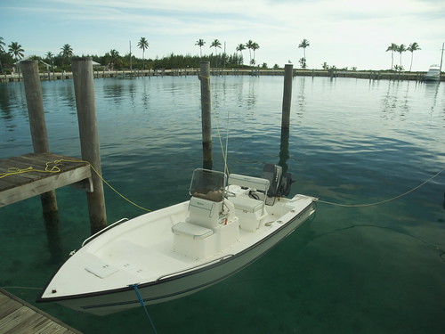
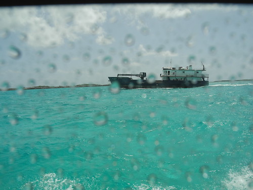
He notices that the wire is very loose and barely making contact on the top end of the outboard motor. He quickly uses a pair of pliers to tighten the wires and is sure that the problem is fixed.

Phewwwwwww!!

What a relief that the problem is NOT caused by something of my making!! That would have been devastating to my ego!!

She quickly starts up again once the wire is reconnected and I spend another 20 minutes exploring Buena Vista Cay.

I had read that a native 73 year old man lives on this island totally off the land. He gets food and water from the mailboat from Nassau. On the "Distant Shores" series on vimeo.com, he was interviewed by a sailing couple a few yrs ago, and when asked if he gets lonely all by himself, he told the camera that he likes the peacefulness and doesn't really feel along, despite what we all might think.

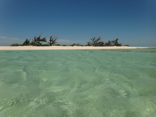
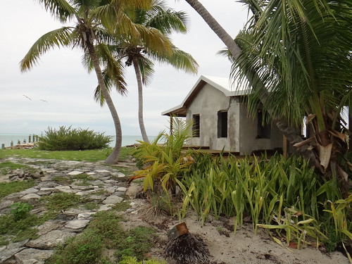
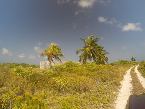
I walked about 500 ft to the N of where I was anchored to see his home. I knew that he was not there at that time since his boat was gone. Tallboy confirmed that he was absent as well as he had gone to Duncan Town on the Mailboat.

So when I am about 100 yards from his place, the dog and rooster sense my presence and become very vocal!!

This is my cue to back off! I certainly don't need to be mauled by his dog!!

Of course, I would not have trespassed on his property if the dog had been absent, but I just wanted to get a bit closer so I could get a few pics.

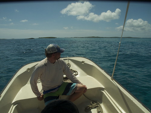
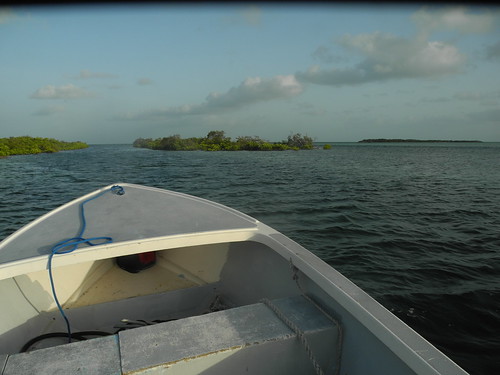
I soon take off for Racoon Cay, about 5 nm to the on a 160 hdg towards Duncan Town. Sure enough, the ocean is rough and wet as I now have a head sea to contend with.

14973430357_818b9497f3.jpg


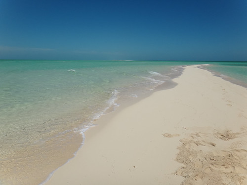
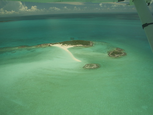
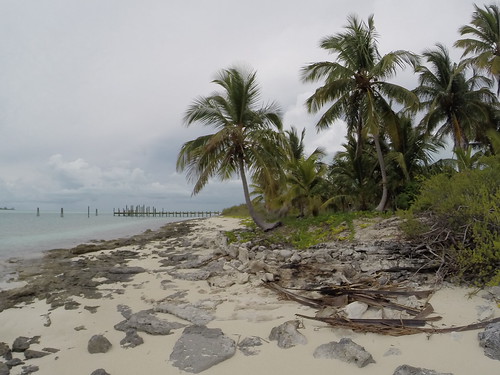
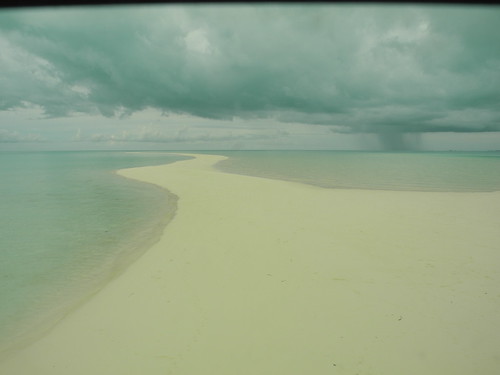
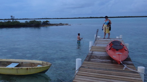
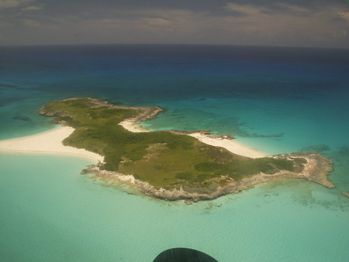
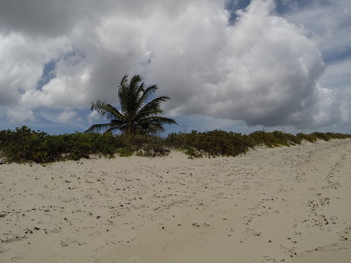
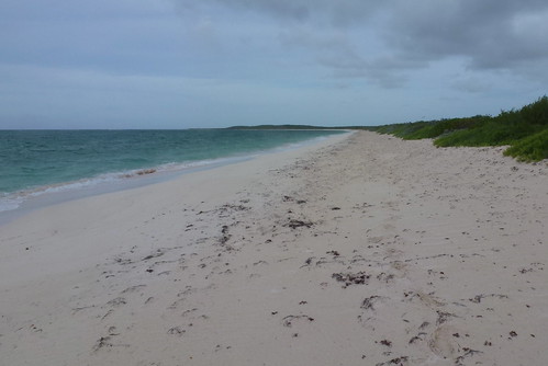
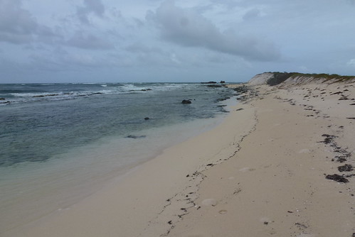
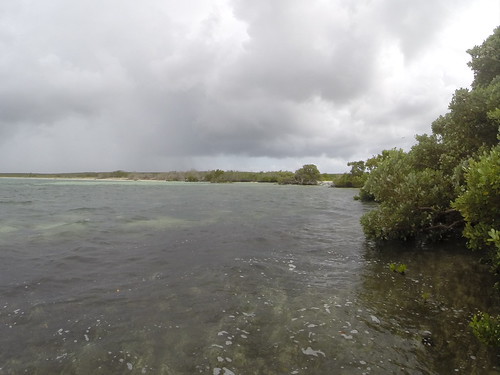
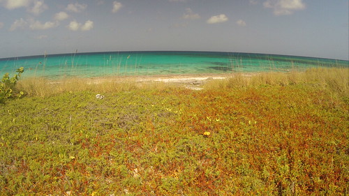
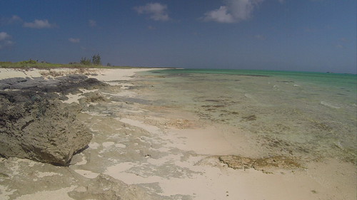
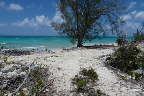
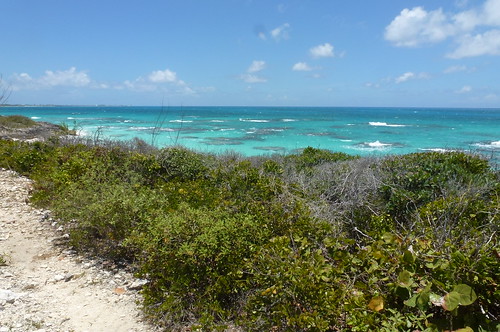
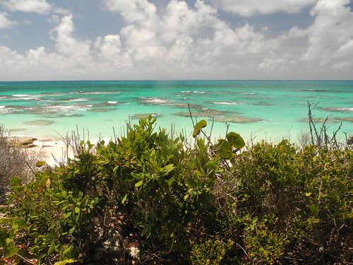
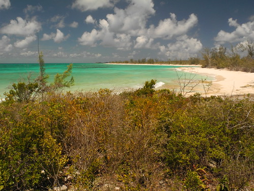
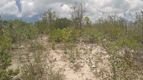
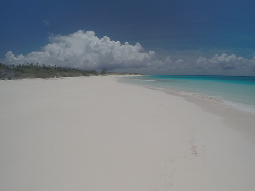
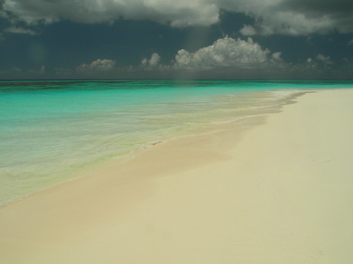
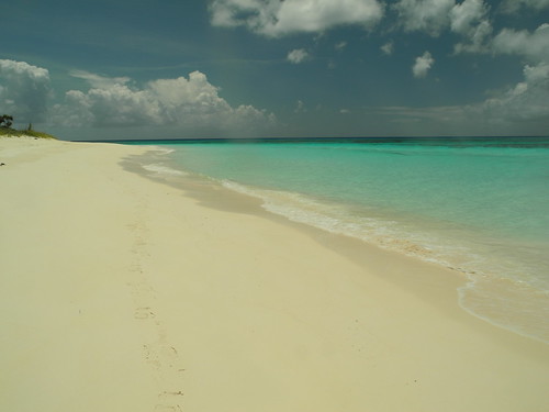
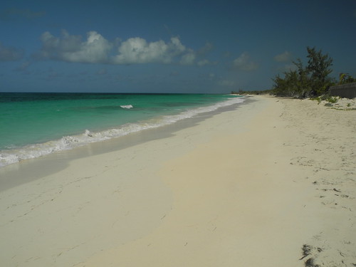
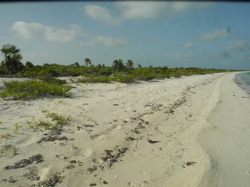
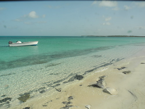
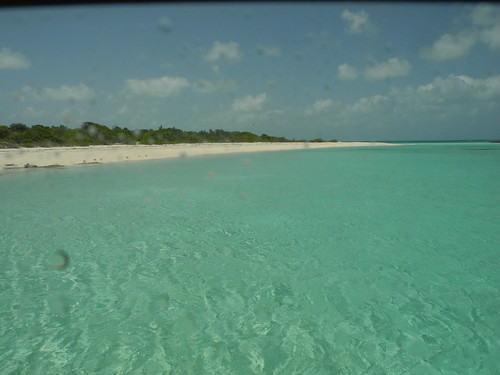
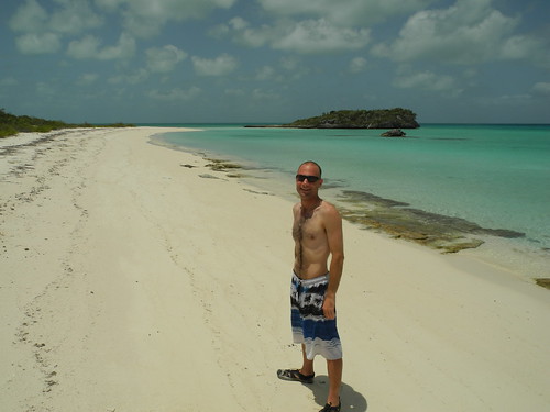
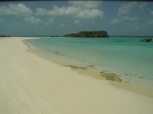
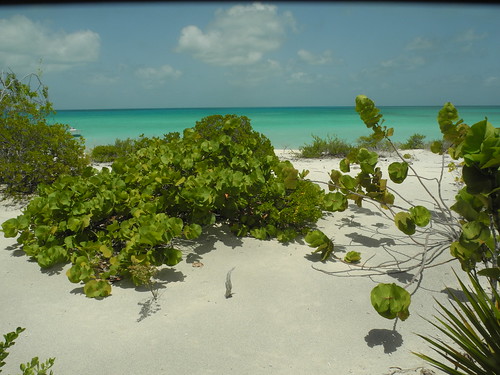
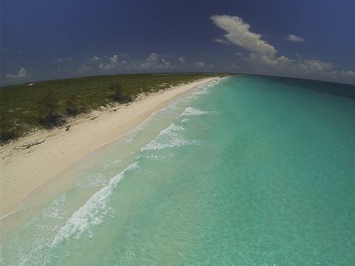
I choose House Bay as the best place to drop anchor---about a third of the way from the SW tip of the island on the sheltered side. This is a lovely cove with a pure white sandy beach and a rock on its south side. The vegetation here is sooo green and picturesque. I spend about 45 min here and get a lot of pics and video.

14973274149_0da9530fa8.jpg


15136971396_9899ff5e48.jpg


15136962126_160eee1810.jpg


15157019321_c42225116e.jpg


As I am walking along this pristine and untouched beach, I can only help but wonder if this is what the Exuma Chain was like in the mid 20th century, or thereabouts??!!

Its something that I ponder as the peacefulness of this place hits me full force. I feel like I've traveled in a nostalgic time machine to an era where life was simpler and strife was minimal.

Soon after, reality hits me full force as I start thinking about the ride back to Duncan Town!

I know its gonna be a rough slog into head seas, most of the way!!

Sure enough, as I get out of the lee of Raccoon Cay and head towards Margaret Shoal Waypoint, the way I came, it becomes rough and wet!!

It is VERY tempting to hug the shore from Margaret Cay to Loggerhead Cay and then Double Breasted Cay, and so on.......but I know that doing that as a newbie, on a almost low and falling tide would be a very BAD idea since there are some very shallow and rocky areas back there.

When it comes down to it, I'll take the pounding in rough seas in deeper water on a published route ANYDAY over a smoother ride in shallow water on a almost low and falling tide!!!

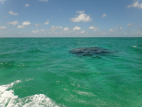
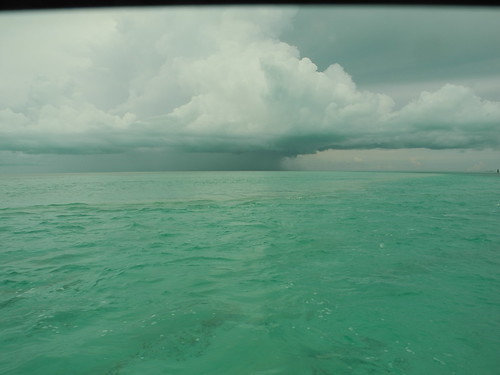
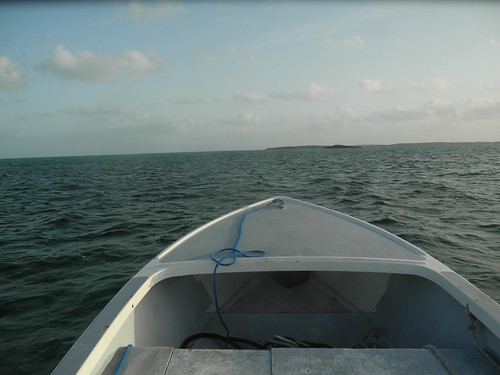
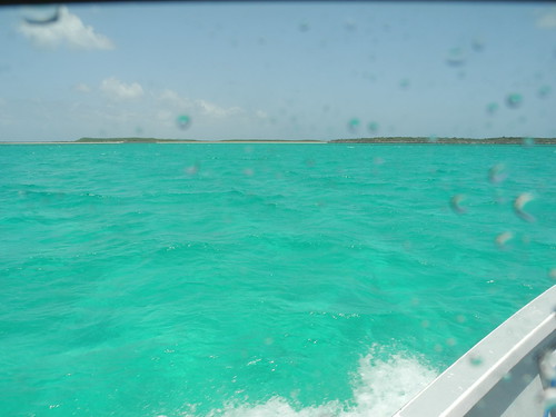
Now about a mile N of Margaret Shoals Waypoint, the sea is right on my beam at my 9 O 'Clock position, and while its not as slow going as a straight head sea would be, its WET!!

VERY WET!!

15136960356_81834053fa.jpg


The thought of tacking crosses my mind (who said tacking is only for sailors...Haha!!), but I soon realize that the added distance I need to travel will only lengthen the total amount of time in this splash!

At no point do I feel my safety is in jeopardy, but its sure is a wet, miserable and nasty ride.

Once I round the bend at Margaret Shoals Waypoint and turn left from a 190 hdg to a 140 hdg, I am now going right into the head seas, and can only do about 8 kts comfortably. I would estimate them to be in the 3-5 ft range. While I am not getting splashed as much as when the sea is off my beam, it is what I call only slightly less unpleasant that what I had 3 nm earlier!

Like I said before, having done both, I FIRMLY believe that camping in a tent, in the middle of January, in Lake Placid (Upstate New York) when the temperature dropped to -25F, was significantly less unpleasant than dealing with 4 ft seas off my bow!! And thats for a whole night vs just 1 or 2 hours on the water!!

In other words, on a per hour basis, winter camping in temperatures well below zero, is MUCH easier than this vengeful ocean, physically, mentally, and emotionally!!

As I continue on a 140 hdg towards the SW tip of Hog Cay, finally after an HOUR of relentless pounding, I finally get enough into the lee of Hog Cay and the N end of Ragged Island to have the seas subside noticably.

What a relief! I am almost home free!

Once I pass the SW tip of Hog Cay, I steer a 180 hdg to pass by a cross built into a rock, and then to the west of Salt Cay, making sure to keep the stakes off to my right.

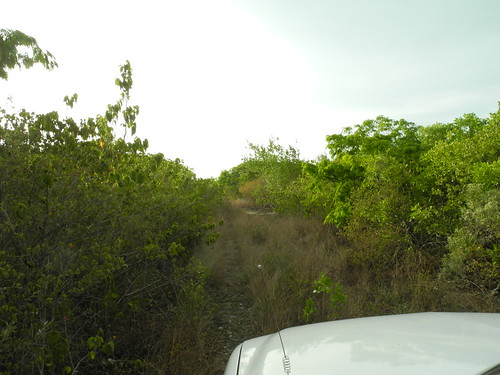
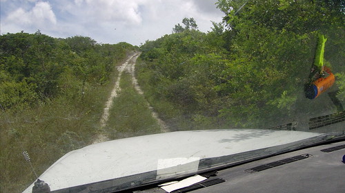
It is right at LT now, so I MAKE SURE to stay right in the middle of the channel as look for the entrance to the dingy channel.

Thank God for Google Earth as I already have the waypoints put into my GPS for this!!

I then turn left from the a 180 hdg to a 130 hdg as I make my way up the dingy channel to get back to the dock.

While the the tide is not in my favor, what i DO have going for me is that it is 2 PM and the sun is very high in the sky and just behind me, giving me great lighting as I head up the dingy channel.

I raise the motor as the water is about 3' deep up the channel, perhaps a bit less. I completely shut off the GPS and navigate up it solely using visual piloting rules and reading the water. Light spots = shallow, darker spots = deeper.

I am getting a bit impatient going just 3 kts up the channel, BUT.......I know that 15 extra minutes is a small price to pay for not damaging the boat!!

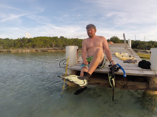
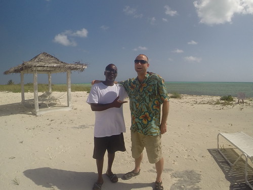
I then make it into the open salt pond and swing her to the NE to pull straight into her parking spot!! Lester is there to greet me and I give thank him again for the boat rental.

I then gather all my belongings and head back to the lodge to shower. At around 3:30 that afternoon, I pay Tallboy for the boat, fuel and room and then get a ride from him back to the airport.

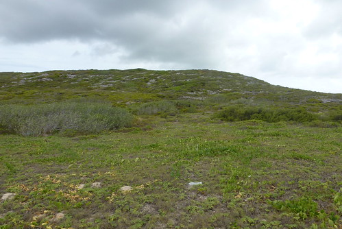
We then stop atop a hill that overlooks the ocean to the SW and he get a few pick of me before dropping me off at the plane.

Now almost 4:00, I give up on going to Cat Island, and choose Nassau instead. As crazy as this sounds, being one who loves remote and beautiful beaches/sandbars, I am ready for a change of pace and Nassau seems to fit that bill. I might make a side trip to Cat Island later on from Nassau, but we'll have to see......

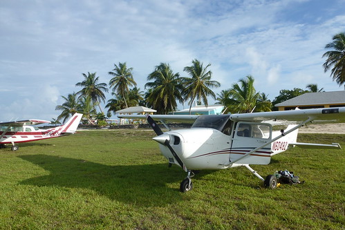
I ask Tallboy if its OK I use his phone to file a flightplan, and he is more than glad to let me. Great man his is! Truly a gentleman.

I depart runway 13 and Tallboy waits in the truck as I takeoff. I tip him a wing on departure and bid farewell.

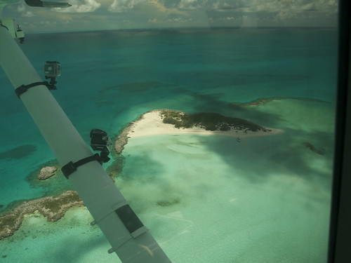
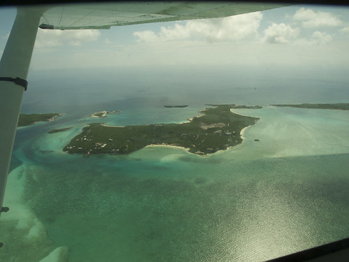
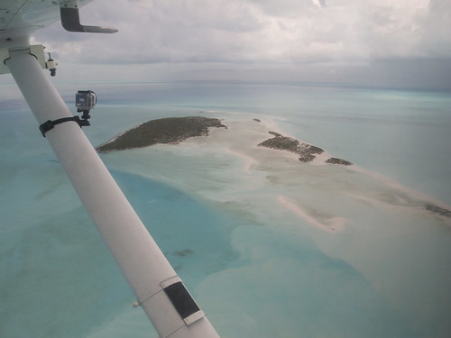
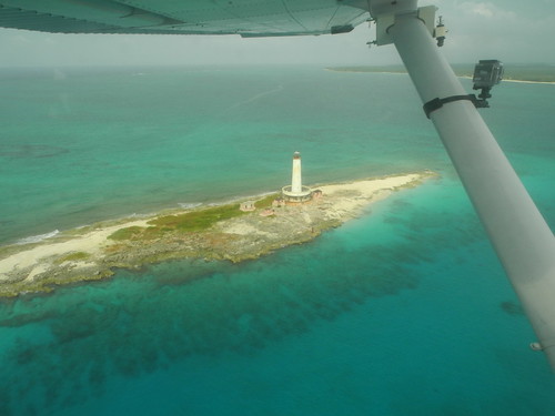
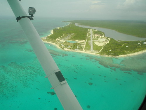
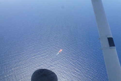
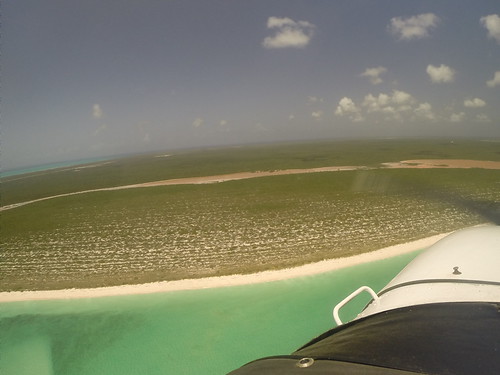
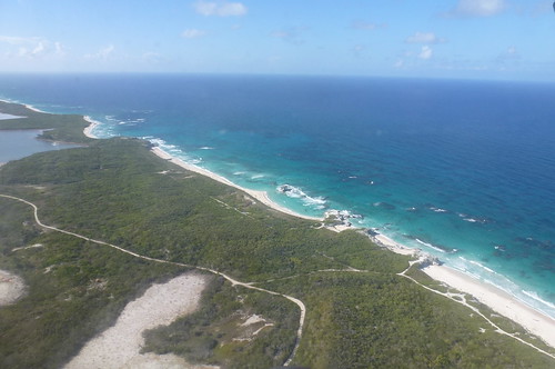
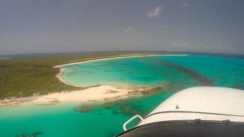
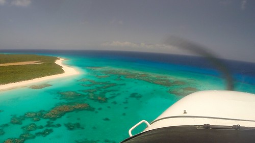
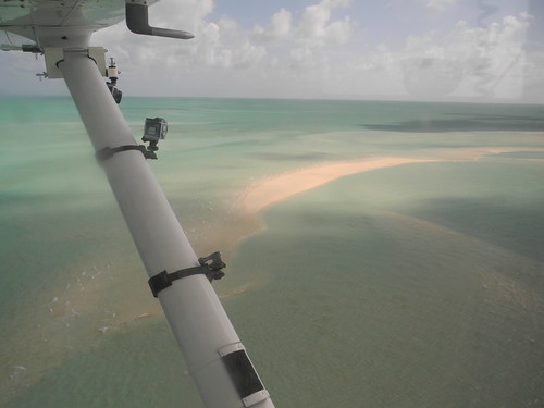
As I make my way back to Nassau, I fly at around 300 ft over the same deserted Cays that I passed by on the boat a few hrs earlier. Once I reach Buena Vista Cay, I go direct to Nassau and climb up to 6500 ft as there are not many more islands to see.

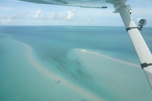
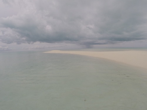
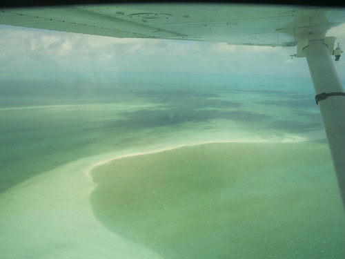
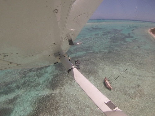
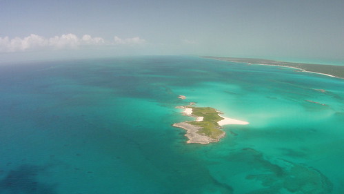
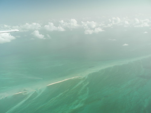
When about 80 nm from Nassau, I notice on my GPS, that there is a circular sandbar, about 30 nm SW of Great Exuma, just before the "Tongue Of The Ocean" towards Andros.

Seeing this, I pull the throttle back and drop to 1500 feet in search of this potential gem.

Unfortunately, I see nothing that resembles such, even taking into account that its coming up on HT.

Oh well.......

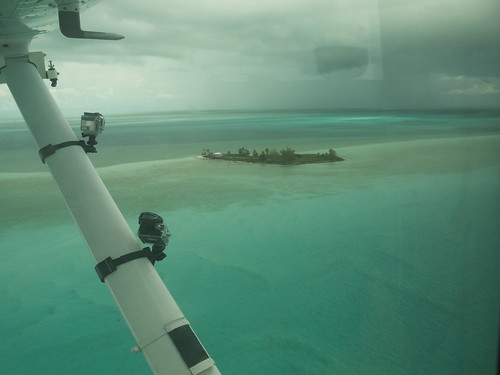
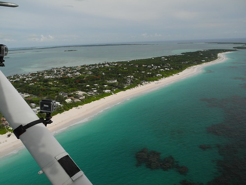
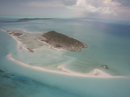
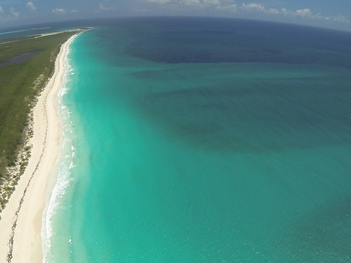
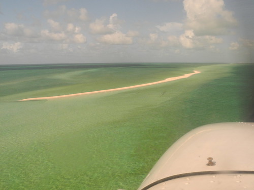
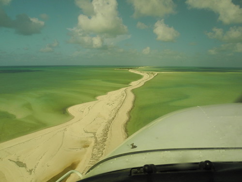
I then continue on course to Nassau and climb back up to 6500'. About 35 nm later, I come upon an all too familiar gem.........once again!!

Where would that place be??

None other than that hidden paradise of sandbars known as the.............

SCRUB CAYS!!

Seeing them from 6500 feet brings back good memories from 12 days earlier when I made it there and back from Staniel Cay.

15159594322_6281d68ac1.jpg


I soon realize that only the western end of these chain of sandbars are visible on my side of the plane (left). To make it this far, I would have had to travel at least another 10 nm on the boat.

No extra value in using my time and gas $$ to go that extra distance as I got the most bang for my buck by visiting the eastern most of the cays.

About 15-20 min later, I contact the Nassau Approach and they give me a code and then vector me behind a stream of airline traffic.

Because its 6 PM on a Friday, there is a LOT of traffic, so I have to fly about 15 nm west of the airport, on a right downwind for rwy 9 before they turn my back.

The landing is nothing special, and I soon taxi to Executive Aviation. Once inside, I try to get a room at the Orange Hill Inn, and unfort they are booked solid.

I was hoping that in the summer they would not be.

Unfortunately, I am stuck with the Junkaboo Down town. Not the best place, but not a complete dump either.

I mean......there IS availability at the Atlantis, but nothing for less than $500/night!

Ughhhh...........I dont think so!!

I finally get a cab to the Junkaboo and its about what I expected. Run down, but not intolerable. $110 a night incl tax. I'll take it. I'm not that picky.......when it come to lodging at least.

I order pizza that night that is delivered right to my room and hit the hay around midnight.

I'm taking it easyyyy tomorrow morning!!!
 
Re: 18 days in paradise and a Masters Degree in Bahama Out Island Exploration w/ HD v

YGTBSM
 
Back
Top