

You are using an out of date browser. It may not display this or other websites correctly.
You should upgrade or use an alternative browser.
You should upgrade or use an alternative browser.
10-13 PA46-350 crash - Baraboo/Lake Delton, WI
- Thread starter fiveoboy01
- Start date

- Joined
- Sep 25, 2019
- Messages
- 828
- Location
- Lancaster, Pennsylvania
- Display Name
- Rick A
- Home Airfield
- KLNS
Nightime at 24,000', widely scattered thunderstorms, and they found one. A PA-46 jet prop reported carrying with 5 adults and one child. RIP.


Doc Holliday
En-Route
That thing is in the ballpark of $1M, right? You'd think they'd put a weather radar on it at that price.
Radar doesn't help if one doesn't know how to use it correctly.

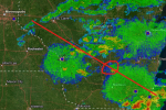
First time using the historical radar view on NOAA site -- but here's what it looked like about 20mins before the crash on radar.
Started in the bottom right and was flying towards Minneapolis area-ish (a little west). Went down near the circle region.
FlightAware plot
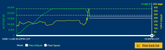
Started in the bottom right and was flying towards Minneapolis area-ish (a little west). Went down near the circle region.
FlightAware plot

Flying Keys
Cleared for Takeoff
- Joined
- Jul 2, 2021
- Messages
- 1,027
- Display Name
- Flying Keys
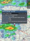 Course approximated. PIREP seems to have come from the accident aircraft - same type, time, and location.
bonefishpete
Cleared for Takeoff
- Joined
- Nov 10, 2024
- Messages
- 1,362
- Display Name
- Bonefishpete
Did the Pilot rip the wings off or did the thunderstorm rip the wings off?
Or in other words did the pilot fly the aircraft outside the design envelope?
Or in other words did the pilot fly the aircraft outside the design envelope?

455 Bravo Uniform
Final Approach
Did the Pilot rip the wings off or did the thunderstorm rip the wings off?
Or in other words did the pilot fly the aircraft outside the design envelope?
PIREP above from accident pilot shows severe icing.
- Joined
- Sep 25, 2019
- Messages
- 828
- Location
- Lancaster, Pennsylvania
- Display Name
- Rick A
- Home Airfield
- KLNS
Did the Pilot rip the wings off or did the thunderstorm rip the wings off?
Or in other words did the pilot fly the aircraft outside the design envelope?
Probably a deadly combination of all three.
The wings may not have ripped off (if in fact they ever did - other stuff can break, including the pilot) until the pilot pulled back on the yoke, increased the angle of attack and loaded up the airframe with excessive G's. The thunderstorm produced the turbulence, vertical columns of severe up and down drafts, and flight environment conducive to a loss of control.
Wagondriver
Line Up and Wait
- Joined
- Mar 7, 2020
- Messages
- 808
- Display Name
- 375Taylor
Seems to me to be worse judgement to fly in that weather than to take off on a river with bridges.
davela
Pre-Flight
This sort of thing seems to keep happening with disturbing regularity. I don't know if this is more an indication of a lack of adequate training regarding weather hazards, or that a significant population of GA pilots simply lack adequate judgement. It does seem to happen to pilots at all experience levels though, indicating both factors may be at play. With more experienced pilots we often see evidence that some attempt to deal with the fatally dangerous weather was actually made in these incidents, though inadequate for the threat level posed and aircraft capability. The latter suggests dangerous behaviors have become normalizated among some higher-time pilots.
MauleSkinner
Touchdown! Greaser!
Be interesting to see the XM radar picture he was seeing at the time, assuming that’s what he was using.

Somewhere there’s a thread that discussed asymmetrical ordnance loading.That thing is in the ballpark of $1M, right? You'd think they'd put a weather radar on it at that price.
- Joined
- Sep 25, 2019
- Messages
- 828
- Location
- Lancaster, Pennsylvania
- Display Name
- Rick A
- Home Airfield
- KLNS
This sort of thing seems to keep happening with disturbing regularity. I don't know if this is more an indication of a lack of adequate training regarding weather hazards, or that a significant population of GA pilots simply lack adequate judgement. It does seem to happen to pilots at all experience levels though, indicating both factors may be at play. With more experienced pilots we often see evidence that some attempt to deal with the fatally dangerous weather was actually made in these incidents, though inadequate for the threat level posed and aircraft capability. The latter suggests dangerous behaviors have become normalizated among some higher-time pilots.
Not sure these higher altitude thunderstorm encounters can be classified into general reasons like lack of training, weather knowledge, a habitual lack of judgement, or high time normalization of hazardous decisions.
Pilots flying turbines in upper teens and low 20's are up there, in part, due to enjoyment of significantly lower fuel flows. As compared with piston aircraft that can choose to fly below cloud bases in visual conditions. Turbulence and icing are also a higher threat at turbine altitudes. Piston powered aircraft flying visually afford a pilot more options for diversions and finding suitable airports, without the need to descend or divert in IMC conditions at higher altitudes in proximity to dangerous weather.
Additionally, higher time pilots may have more experience due to flying more often, and their incomes during accumulation of their flight time may have depended (in part) upon not staying on the ground when the weather could turn worse than forecast, or what was expected. Newer pilots often "don't know what they don't know".
IMO, dangerous behaviors can be normalized in pilots with any amount of time. High time can also be an indication of safe flying, as low time pilots are no stranger to be weeded out early.
MauleSkinner
Touchdown! Greaser!
Turboprops do pretty well down low in visual conditions when dodging thunderstorms.Pilots flying turbines in upper teens and low 20's are up there, in part, due to enjoyment of significantly lower fuel flows. As compared with piston aircraft that can choose to fly below cloud bases in visual conditions.

dans2992
En-Route
- Joined
- Jan 7, 2013
- Messages
- 4,309
- Display Name
- Dans2992
The vast majority do have radar.That thing is in the ballpark of $1M, right? You'd think they'd put a weather radar on it at that price.



I often thought that - if I ever stepped up to a Turboprop like this from a (non-Turbo) Mooney -- I will commit myself to fly it just like the Mooney: Plan your flights AROUND thunderstorms and AFTER they passed through, using XM-type weather radar for strategic planning to fly around questionable weather or just landing and waiting it out.
In many of these types of accidents it seems to me that it comes down to disciplined risk management following iron-clad rules -- just like commercial aviation does it...
In many of these types of accidents it seems to me that it comes down to disciplined risk management following iron-clad rules -- just like commercial aviation does it...
Lindberg
Final Approach
Certainly better than they IN thunderstorms.Turboprops do pretty well down low in visual conditions when dodging thunderstorms.

bbchien
Touchdown! Greaser!
HUBRIS
- Joined
- Sep 25, 2019
- Messages
- 828
- Location
- Lancaster, Pennsylvania
- Display Name
- Rick A
- Home Airfield
- KLNS
I often thought that - if I ever stepped up to a Turboprop like this from a (non-Turbo) Mooney -- I will commit myself to fly it just like the Mooney: Plan your flights AROUND thunderstorms and AFTER they passed through, using XM-type weather radar for strategic planning to fly around questionable weather or just landing and waiting it out.
In many of these types of accidents it seems to me that it comes down to disciplined risk management following iron-clad rules -- just like commercial aviation does it...
Iron-clad rule... like staying visual? IMO, that's priority #1, regardless of what altitude you're flying at while you consider navigating around an area ripe for, or exhibiting convective weather. Whether or not it's producing rain, or lightning.
Researchers that have intentionally flown armored aircraft (T-28's?) through massive North Dakota thunderstorms, say developing storms not yet showing extreme rain or lightning can be just as bad (or worse) as some fully developed ones.

I think you concisely summed up the future NTSB report.HUBRIS
davela
Pre-Flight
Good point about staying visual. This brings up another TS hazard that I was not fully aware of till explained to me by a very experienced instructor in my earlier flying days (it should be taught in primary flight training).That is the danger of long night VFR cross country flights on summer days in TS prone areas of the US, which means a good segment of the country (Texas, NM, and the deep South most notably). His general rule when ferrying planes was daytime flying, preferably early in the day. Cells can be present at night, but simply not seen until an encounter. Of course TS activity tends to moderate at night, but not always.Iron-clad rule... like staying visual? IMO, that's priority #1, regardless of what altitude you're flying at while you consider navigating around an area ripe for, or exhibiting convective weather. Whether or not it's producing rain, or lightning.
Researchers that have intentionally flown armored aircraft (T-28's?) through massive North Dakota thunderstorms, say developing storms not yet showing extreme rain or lightning can be just as bad (or worse) as some fully developed ones.
- Joined
- Sep 25, 2019
- Messages
- 828
- Location
- Lancaster, Pennsylvania
- Display Name
- Rick A
- Home Airfield
- KLNS
Even if the you were guaranteed to make it through. It ain't gonna be pleasant
Yeah, for sure. If through some bizarre string of events where it ever happens, my game plan is;
Yank the seat belt as tight as possible while quickly reducing power to a setting somewhere around maneuvering speed, wrestle to keep the wings as level as possible, keep the airspeed within a range centered somewhere near maneuvering speed, and just ignore the altimeter and heading.
During the above I'd probably lower the volume on the radio and intercom down to zero. At that point of transgression, nothing you can hear from anyone is going to help you survive if you don't focus on the above.
MauleSkinner
Touchdown! Greaser!
One of the things I gleaned from Archie Trammel back in the day was that the red isn’t necessarily a worse ride than the green or yellow…turbulence in a thunderstorm return can be equal to the heaviest return anywhere in the area of radar return.Researchers that have intentionally flown armored aircraft (T-28's?) through massive North Dakota thunderstorms, say developing storms not yet showing extreme rain or lightning can be just as bad (or worse) as some fully developed ones.
MauleSkinner
Touchdown! Greaser!
I wouldn’t ignore heading…AC 00-24C statesjust ignore the altimeter and heading.
A straight course through the storm most likely will get the aircraft out of the hazards most quickly.
bonefishpete
Cleared for Takeoff
- Joined
- Nov 10, 2024
- Messages
- 1,362
- Display Name
- Bonefishpete
I would like to know the tops of these storms? Any hail in the area? Wind gusts?

Plano Pilot
Cleared for Takeoff
That reminds me of a flight in a Sabreliner years ago. We departed Palm Beach early night headed to Dallas and lost the radar after departing. There was a pretty good line of TS near New Orleans, by the time we got to the line we were up at FL450. With the help of FSS, ATC and Mark 1 eyeballs seeing the lightning flashes we were able to go over the line. The lightning flashes would light up the tops of the T-storms.Good point about staying visual. This brings up another TS hazard that I was not fully aware of till explained to me by a very experienced instructor in my earlier flying days (it should be taught in primary flight training).That is the danger of long night VFR cross country flights on summer days in TS prone areas of the US, which means a good segment of the country (Texas, NM, and the deep South most notably). His general rule when ferrying planes was daytime flying, preferably early in the day. Cells can be present at night, but simply not seen until an encounter. Of course TS activity tends to moderate at night, but not always.

Kenny Phillips
Final Approach
- Joined
- Jul 29, 2018
- Messages
- 6,572
- Display Name
- Kenny Phillips
In the only daylight picture I've seen of the wreckage I couldn't determine if the horizontal stab was present. Over-controlling is a thing, and has prematurely ended more than one flight where doing less would be better.
- Joined
- Sep 25, 2019
- Messages
- 828
- Location
- Lancaster, Pennsylvania
- Display Name
- Rick A
- Home Airfield
- KLNS
"A straight course through the storm most likely will get the aircraft out of the hazards most quickly."I wouldn’t ignore heading…AC 00-24C states
I hear you and agree go straight ahead if you can, or at least try to stay inside a quadrant out front.
The only instance of severe turbulence I ever encountered (temporarily out of control) was the inside of a mountain rotor. Just keeping the plane from exceeding 90 degrees of bank and fighting to get back to wings level was the goal, and remaining level enough for a near accurate heading would have been impossible. I was VMC being pulled down by a strong downdraft towards the clouds on top of a broken layer.
Answering ATC's inquiry wondering WTH was going on as the groundspeed had quickly dropped to less than 40kts was mostly grunts, sounding like trying to talk while taking body punches. I could only imagine a thunderstorm's turbulence would be worse than that, and a lot longer in duration. Interpreting and flying instruments while IMC inside a thunderstorm would be an event I'd hate to even consider.

Flying Keys
Cleared for Takeoff
- Joined
- Jul 2, 2021
- Messages
- 1,027
- Display Name
- Flying Keys
Echo tops on that cell were observed to be between FL350-400. It was a developing cell, moving from almost due west to east, that intensified and peaked near the accident site to a bit east of there, then dissipated. From what I can see, there wasn’t a lot of lightning from that cell until right as it was passing over the accident site and a little beyond before dissipating.I would like to know the tops of these storms? Any hail in the area? Wind gusts?
The precip core of the associated storm passed a mile or two south of KDLL. There wasn’t anything in the way of strong winds, gusts, or any peak winds reported by the nearby automated stations, but there was a slight wind shift (just a few knots) associated with the passage of the system. Still could be considered light and variable. No hail or severity from that or any nearby storms reported at SPC, but that doesn’t rule out hail aloft or smaller hail/graupel in areas that went unobserved.
The thunderstorm forecast at 0100z showed that area was right on the western edge of thunderstorm development at 0200z (fairly true to what happened). However, the convective sigmet for that cluster was not issued until 0255, almost 30 minutes after the accident. Basically, the cell moved into a more favorable area for development right as the accident aircraft was passing through. However, the areas 50-ish miles north and south of the route were already under the gun, indicative of larger-scale instability. At the time the accident flight launched, it was a corridor fairly clear of echoes (just a couple light ones), hindsight revealing the proverbial “sucker hole.”
The icing forecast did show an area of moderate icing at about that place and time. SLDs were indicated a bit lower - between 150 and 210. The freezing level was forecast somewhere around 120-130.
The 0100z forecast discussion was fairly innocuous - “at times we have seen some growth where hail became a mild concern but storm growth never ended up becoming significant enough to worry about larger hail and we do not anticipate storms getting much stronger as they track across southeast WI over the next few hours.”

sourdough44
En-Route
Why do pilots think they have to go direct? Is fuel too expensive now days?
Wait for the storms to clear Kenosha, then fly West, hook it north after you get past the convective weather. No not just in hindsight, but an actual plan at departure time.
The accident was 21:30, maybe a somewhat long day? On top of all that, I don’t really care to attend funerals.
Wait for the storms to clear Kenosha, then fly West, hook it north after you get past the convective weather. No not just in hindsight, but an actual plan at departure time.
The accident was 21:30, maybe a somewhat long day? On top of all that, I don’t really care to attend funerals.