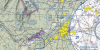
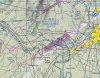
You will need to have a Baltimore/Washington TAC to possibly answer this. Looking at the TAC near the 200 Radial of the Hagerstown VOR there is a magenta ellipse. I know that typically the thick magenta line means Class E to 700 AGL, but in this case I am confused. If you follow the Class E (to 700) airspace boundary (not the ellipse but the major boundary) around it is a continous boundary. Is this ellipse an exclusion and the small area inside class G? There is also one a little north of Quantico. Thanks in advance I am interested to hear an answer or at least a theory.
Chris
The small area inside has a Class E floor of 1200' AGL. The area outside has a Class E floor of 700' AGL. The small area inside is what is left over after the two Class E5 areas below are established:
AEA DC E5 Washington, DC
That airspace extending upward from 700 feet above the surface within an area bounded by a line beginning at lat. 38°55’19” N., long. 76°12’28”W., to lat. 38°27’18”N., long. 77°03’51”W., to lat. 38°36’30”N., long. 77°15’17”W., to lat. 38°35’12”N., long. 77°37’06”W., to lat. 38°57’17”N., long. 78°02’29”W., to lat. 39°30’00”N., long. 78°09’00”W., to lat. 39°44’36”N., long. 77°36’08”W., to lat. 39°43’28”N., long. 77°00’00”W., to lat. 39°36’08”N., long. 76°28’38”W., to lat. 39°19’38”N., long. 76°04’04”W., to the point of beginning excluding the airspace that coincides with the Aberdeen, MD, Hagerstown, MD, Winchester, VA, Midland, VA Class E airspace areas and P-56A, P-56B, P-73, P-40, R-4009, R-4001A, R-4001B, R-6608A, R-6608B and R-6608C when they are in effect.
AEA MD E5 Hagerstown, MD
Washington County Regional Airport,
Hagerstown, MD
(lat. 39°42'28"N., long. 77°43'46"W.)
Hagerstown VOR
(lat. 39°41'52"N., long. 77°51'21"W.)
St. Thomas VORTAC
(lat. 39°56'00"N., long. 77°57'03"W.)
Washington County Regional Airport ILS
Runway 27 Localizer
(lat. 39°42'22"N., long. 77°44'41"W.)
That airspace extending upward from 700 feet above the surface within a 6.6-mile radius of the Washington County Regional Airport and within 3.1 miles each side of the Hagerstown VOR 237° radial and 057° radial extending from 9.6 miles southwest of the VOR to 2.7 miles northeast of the VOR and within 4.4 miles each side of the Washington County Regional Airport ILS Runway 27 localizer course extending from the localizer to 12.6 miles east of the localizer and within 4.4 miles each side of the St. Thomas VORTAC 141° radial extending from the 6.6-mile radius to the St. Thomas VORTAC, excluding that portion within Prohibited Area P-40.