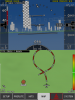
X-aviaonics

I'll be buying Xavion after watching this video:


Once thing I'm curious about... if you're running it in the background, with ForeFlight HD running in the foreground, does Xavion still track your position and energy so you can flip over to it quickly in an engine out scenario for a glide solution?
 
Once thing I'm curious about... if you're running it in the background, with ForeFlight HD running in the foreground, does Xavion still track your position and energy so you can flip over to it quickly in an engine out scenario for a glide solution?


From my understanding, No.

It expects you to have an iPad dedicated to it more or less. If you switch to it I believe it is 30 seconds or so to get it's bearings. This is one of the first questions I had asked the author. I still think the app is great and will get it when it supports the AHRS I have.

You're correct. However, since I also have an iPhone 5, I can run Xavion on the iPhone 5 all the time, and Foreflight on the iPad, and have data from both. Covered on this page:

http://xavion.com/app/hardware/
 
You're correct. However, since I also have an iPhone 5, I can run Xavion on the iPhone 5 all the time, and Foreflight on the iPad, and have data from both. Covered on this page:

http://xavion.com/app/hardware/

I have xavion on my iPhone 4 and I have tested it with the Bad Elf plug-in. Works pretty well, but I've mostly flown with it while practicing instrument approaches, and it always says I'm low-energy, won't make the field :) Looking forward to taking it on a longer flight when I'm up higher and going faster, to see what it says.

Based on my experience you should plan keeping your iPhone plugged-in to a charger: screen ON bright enough to see + xavion + Bad Elf = surprisingly short battery life.

FYI: I mounted the phone using a suction mount on the windshield, and wedged the bottom of the suction mount arm against the top edge of the glare shield so it didn't vibrate as much. Mounting the phone inverted (so the Bad Elf was "up") worked better, but xavion doesn't automatically invert - you have to go into xavion settings to change screen orientation.
 
Last edited:
Is the $95 a one time fee, or a subscription? I couldn't tell from the product site or App Store. I'd almost expect a subscription due to the need to keep airport data up to date.
 
Is the $95 a one time fee, or a subscription? I couldn't tell from the product site or App Store. I'd almost expect a subscription due to the need to keep airport data up to date.

Austin replied quickly to my email question, on a Sunday, no less!

one-time purchase, FOR NOW.

but, in the future, optional subscriptions will be added to keep stuff up to date.
 
If you use Xavion in an emergency, cross check where it's trying to send you with ForeFlight or some other backup. His database (not sure where he sourced it) has some VERY old and closed airports in it. Here's my initial PIREP to Austin:

OK, I went ahead and purchased it (per our discussion earlier today) and already have a major concern! I fired it up on my iPad from my home, connected to my XGPS-150, and found that it was looking at a nearby grass field, 71TS, as the place it would send me. (see screen shots attached)


1) 71TS has been a WALMART SUPERMARKET for at least 3 years!! See http://airportnavfinder.com/airport/71TS/ and the Google Map shown on that page. Would REALLY suck to follow the hoops down through IMC and see a Walmart where an airport should be!! What source of airport data did you use? It wouldn't try to send me to a heliport would it?

attachment.php


attachment.php


2) Does the system automatically prefer hard surface runways over grass if both are in range but the hard surface is further away? I'd like a way to be able to differentiate on the map between hard surface / grass airports, and even to override which of the "in range" airports the emergency mode would take me to, by touching my desired airport on the map. I might pick one over another based on local knowledge.
 

Attachments

  • photo 1.PNG
    photo 1.PNG
    660.5 KB · Views: 108
  • photo 2.PNG
    photo 2.PNG
    301.2 KB · Views: 9
  • photo 3.PNG
    photo 3.PNG
    166.9 KB · Views: 107
Austin's reply, To point #1:

plan to use a professional data update service some time this year
for now, simply touch the airport and select the runway you like, it gives you a bad solution like that

To point #2:

it treats them both as equal
since this is emergency use, i figured that a grass runway is just as good.. it would help get you stopped!
also they tend to be wider in my experience
 
His database (not sure where he sourced it) has some VERY old and closed airports in it.

From Xavion's website:

Airports
Xavion includes about 27,000 airports as of this writing. This airport database is based on the DAFIF airport database, upgraded with thousands of additional airports. For a complete list of airports covered by the software, download the listing. ATIS and Tower or UNICOM frequencies are provided for each airport… just enough to let you contact them to check the weather and let them know you are coming in.

Wikipedia says the following about DAFIF:

Withdrawal of public access

DAFIF was publicly available until October 2006 through the Internet, however it was closed to public access because 'increased numbers of foreign source providers are claiming intellectual property rights or are forewarning NGA that they intend to copyright their source'.[1] Currently only Federal and State government agencies, authorized government contractors and Department of Defense customers are able to access the DAFIF data.
At the time of the announcement, the NGA did not say who the 'foreign source providers' were. It was subsequently revealed that the Australian Government was behind the move. The Australian Government Corporation Air Services Australia in September 2003 started charging for access to Australian data. Rather than exclude the Australian data, the NGA opted to stop making the data available to the public.[2]
 
From my understanding, No.

It expects you to have an iPad dedicated to it more or less. If you switch to it I believe it is 30 seconds or so to get it's bearings. This is one of the first questions I had asked the author. I still think the app is great and will get it when it supports the AHRS I have.

There's a new version that just came out that has quick-start functionality that's supposed to drop the cold startup time to under 15 seconds.

My inner geek wants to have about 3 or 4 iPads in the cockpit running various software. :D
 
Once thing I'm curious about... if you're running it in the background, with ForeFlight HD running in the foreground, does Xavion still track your position and energy so you can flip over to it quickly in an engine out scenario for a glide solution?

Austin's email below might be a partial solution to what you wanted.

I'm guessing that as the ipad platform will get more processing power, and because Austin seems to endorse Fore Flight, in the future these two apps could integrate each other's functionality (as in: press the panic button while crusing with FF active and xavion component will immediately be in foreground - wishing you "Good Luck and Fly the Plane")

OK an update on Xavion!

People keep asking for the same two things:

1: Landscape mode.
2: Ability to run ForeFlight in the foreground, and then invoke Xavion in an emergency.


Xavion Version 1.12 is now out, and it now does both of these things!
Landscape mode is available, and the latest Xavion (1.12) boots and does a very rapid airport search in under 30 seconds to find the best solution on app-start.


So, Xavion is rapidly developing, and these are the latest updates… get it at the iTunes AppStore now.. it is really amazing!


austin
 
AA688, DFW-PHL. 24 seconds from cold start of application to GPS fix gliding solution. 29 minute glide from this high up based on the default settings in Xavion. I bet it would be less in the 737. I need to go configure the glide and airspeed parameters in Xavion for the planes I fly. My wish list includes a library of shared aircraft profiles, ala Jesse's WnB Pro.

ysyze4y2.jpg


y7u5yjy7.jpg
 
I went with Clarity instead of iLevil. So far so good with Wingx. Just waiting on Xavion
 
Has anybody ever head of a box that ties in the pitot static system for airspeed and indicated altitude to transmit this date via bluetooth to an ipad? Would it be so hard to devise such an interface between the PS system to a digital box that transmits a bluetooth signal to an ipad so that we don't have to rely on groundspeed and gps altitude on Apps like Xavion? Any technurds out there with a reasonable short answer would be appreciated. (BTW, I use that expression with affection). Dave A.
 
Has anybody ever head of a box that ties in the pitot static system for airspeed and indicated altitude to transmit this date via bluetooth to an ipad? Would it be so hard to devise such an interface between the PS system to a digital box that transmits a bluetooth signal to an ipad so that we don't have to rely on groundspeed and gps altitude on Apps like Xavion? Any technurds out there with a reasonable short answer would be appreciated. (BTW, I use that expression with affection). Dave A.

It probably won't happen for certificated aircraft. The iLevel is close to what you're looking for on experimental, though. http://www.aviation.levil.com/iLevil.htm
It's WiFi instead of Bluetooth, though.
 
Has anybody ever head of a box that ties in the pitot static system for airspeed and indicated altitude to transmit this date via bluetooth to an ipad? Would it be so hard to devise such an interface between the PS system to a digital box that transmits a bluetooth signal to an ipad so that we don't have to rely on groundspeed and gps altitude on Apps like Xavion? Any technurds out there with a reasonable short answer would be appreciated. (BTW, I use that expression with affection). Dave A.

I think it would require its own pitot source. Perhaps if you have an Aspen or G-500/600/1000... with an air data computer already you could tap the info there. If you are experimental, there are air data computers available for various glass installations but I have no idea if any of them have built in Bluetooth.
 
I have severe doubts about relying on anything using the iPhone/iPad internal accelerometers. I've done some experimentation with this before and absent something holding it rigidly to the aircraft, it's going to be all over the place, running a low pass filter to get rid of the mount shakes isn't going to be real reassuring.
 
Back
Top