Bob Bement
Pattern Altitude
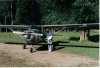
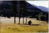
The Minam Lodge is in Northeastern Oregon. It is located in the bottom of a canyon, along the Minam River. It is about 17 miles east of LaGrande Or. The field elevation is 3600' and is about 2600' long. The strip is sod and gravel. You land up stream and take off down stream normally. There is a ridge on each side of the canyon about 7500' in elevtion. The website for the lodge is minamlodgeoutfitters.com with pictures and info. It is a roadless area, the closest road is at the trail head about 8 miles away at Moss Springs. Reds Horse ranch is just above this place but it is closed, as the forest service took it over. In the picture The Minam is in the upper left hand portion of the picture. (Picture) Bob