It's a maybe.
")
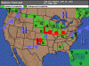
Surface guesses on either side of Friday noon:
So, that tells us... Nothing useful, at this point. It might suck, or it might not.
The only other tool that ever seems to be worth a crap this far out is USAirNet. Right now, for
KFDK at 2:00 PM local on Friday they're calling for 6SM HZ, broken ceiling >12,000 feet, 12% chance of precip and 19% chance of TSRA. Also, 3-knot winds and mid-90's temps... Go high and keep your wife cool and comfy. Hopefully the clouds will keep the thermals from getting too strong.
Anyway, at 5 PM (the next forecast time) they're calling for P6SM, clear below 12,000 but 50% chance of precip and 63% chance of TSRA, with relatively high chances for both for the remainder of Friday and Saturday (they only forecast 72 hours out, so nothing for your return yet).
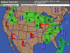
At
KFRG Friday, much nicer temps, vis and clouds OK but steadily increasing chance of precip and TSRA throughout the day. 17% and 18% respectively at 11 AM and 2 PM, up to 29% and 44% at 5 PM and 8 PM.
En route, it looks like
Wings (KLOM) is about halfway, and also calling for good weather at 2 PM with 10%/16% chances, and at 5 and 8 it's calling for 40%/55%.
So, at this point I would say "Go, but go as early as possible."