Let'sgoflying!
Touchdown! Greaser!
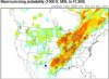
A hypothetical.
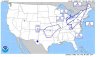
You need to get out: SE piston, non-deiced.
The location is west Texas, 4500'msl
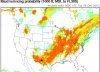
Temp/DP spread is nil, its cold. Thick clouds, no breaks, no light areas.
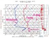
1. skew T guys, where are the tops?
2. how bad do you think the ice will be; why?
The hours are slightly off, metar and charts - ignore.
KE38 041735Z AUTO 08003KT 1/2SM OVC002 M02/M02 A3015 RMK AO2 T10201022
KE38 041715Z AUTO 08004KT 1/4SM OVC002 M02/M02 A3015 RMK AO2 T10231025
KE38 041655Z AUTO 09005KT 1/4SM OVC002 M02/M02 A3016 RMK AO2 T10231025
KE38 041635Z AUTO 07006KT 1/4SM OVC002 M02/M02 A3017 RMK AO2 T10231025
KE38 041615Z AUTO 09006KT 1/4SM OVC002 M02/M02 A3018 RMK AO2 T10231025
KE38 041555Z AUTO 08007KT 1/2SM OVC002 M02/M02 A3018 RMK AO2 T10231025
You need to get out: SE piston, non-deiced.
The location is west Texas, 4500'msl
Temp/DP spread is nil, its cold. Thick clouds, no breaks, no light areas.
1. skew T guys, where are the tops?
2. how bad do you think the ice will be; why?
The hours are slightly off, metar and charts - ignore.
KE38 041735Z AUTO 08003KT 1/2SM OVC002 M02/M02 A3015 RMK AO2 T10201022
KE38 041715Z AUTO 08004KT 1/4SM OVC002 M02/M02 A3015 RMK AO2 T10231025
KE38 041655Z AUTO 09005KT 1/4SM OVC002 M02/M02 A3016 RMK AO2 T10231025
KE38 041635Z AUTO 07006KT 1/4SM OVC002 M02/M02 A3017 RMK AO2 T10231025
KE38 041615Z AUTO 09006KT 1/4SM OVC002 M02/M02 A3018 RMK AO2 T10231025
KE38 041555Z AUTO 08007KT 1/2SM OVC002 M02/M02 A3018 RMK AO2 T10231025
Attachments
Last edited:


")