Ray F
Pre-Flight
How do I figure out the true course on a sectional using a plotter if the course is almost due north. The line I've drawn on my sectional doesn't cross a line of longitude. Thanks guys.
KISS. Just use a line of latitude and add/subtract 90 deg.
Don't make it harder than it is.
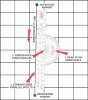
If your course is nearly north or south and does not cross a meridian, place the hole of your plotter over a parallel (line of latitude), and use the inner scale . no math needed.....:
A lot of people forget what the inner scale is for.
Or the were never taught.

Good luck trying that one on your checkride. Or even for a basic diversion.Or, if you're lazy and want to get by without plotting your course, use the Magic Course Heading Finder Application!
<Looks down at plotter...>Happy to be of service

How do I figure out the true course on a sectional using a plotter if the course is almost due north. The line I've drawn on my sectional doesn't cross a line of longitude. Thanks guys.
Use this website, which will print the tool you need to align your course with another parallel course like Murphey said. The FAQ's are very helpful. Or, if you're lazy and want to get by without plotting your course, use the Magic Course Heading Finder Application!

I seem to recall doing this at a time when there was no internet.