UPS data suggest approach or equipment anomalies

taters

Pattern Altitude
Joined
Jun 29, 2007
Messages
1,712
Display Name

Display name:
Taters
Aviation Week


Looks like Loc 18 was performed with AP/AT on all the way , somehow they flew it right into the ground...wonder what was set in the ALT window ?
 
In the aircraft I fly
it should be set to MDA 1200..at ALTS Capture you call for GA to be set.
 
In the aircraft I fly
it should be set to MDA 1200..at ALTS Capture the you click off /cancel FD and call for GA to be set.

Airbus you set the GA altitude passing the FAF on NP approach. If during the approach you hit "TOGA" the airplane will go to the commanded altitude.
 
Last edited:
This is beginning to sound like that freight carrier accident a few years ago where the pilot had vision problems and misread the VASI resulting in sinking into the ground short of the runway around sunrise somewhere in the Southeast US. Can't remember the details.
 
The guy called runway in sight after ,they got 2 GPWS sink rate warnings....should have been an automatic Go Around.
 
This is beginning to sound like that freight carrier accident a few years ago where the pilot had vision problems and misread the VASI resulting in sinking into the ground short of the runway around sunrise somewhere in the Southeast US. Can't remember the details.
Now I have it -- this one.
 
Wasn't there a GA crash at Lee or somewhere with viagra-induced color deficiency?
Dunno. The FedEx pilot at TLH had a congenital color vision defect, and the folks flying Part 121 should all be well aware of the issues surrounding Viagra taken less than some number of hours before flight. If that is a factor in the UPS crash, they'll find it in the blood toxicology. Note that Rwy 18 at BHM has a 4-light PAPI on the left side but no electronic GS -- just like TLH.
 
Does EGPWS tell you anything if you're short of the runway?
 
Does EGPWS tell you anything if you're short of the runway?

That's a "it depends" situation.

From the A319/320 FCOM:

The Ground Proximity Warning System (GPWS) generates aural and visual warnings, when one of
the following conditions occurs between radio altitudes 30 ft and 2450 ft.
‐ Mode 1: Excessive rate of descent.
‐ Mode 2: Excessive terrain closure rate.
‐ Mode 3: Altitude loss after takeoff, or go-around.
‐ Mode 4: Unsafe terrain clearance when not in landing configuration.
‐ Mode 5: Too far below glideslope.
In addition to the basic GPWS functions, the GPWS has an enhanced function (EGPWS) which
provides, based on a worldwide terrain database:
‐ A Terrain Awareness Display (TAD), which predicts the terrain conflict, and displays the terrain on
the ND.
‐ A Terrain Clearance Floor (TCF), which improves the low terrain warning during landing.
The EGPWS uses the geometric altitude. The geometric altitude is calculated by means of a specific
algorithm that uses the following as inputs: The pressure altitude, GPS altitude, radio altitude, and
data from the terrain database.
The cockpit loudspeakers broadcast, even if turned off, the aural warning or caution messages
associated with each mode. The audio volume of these messages is not controlled by the
loudspeaker volume knobs. (These knobs only allow volume adjustment for radio communication).
PULL UP or GPWS lights, on the Captain and First Officer instrument panels, come on to give a
visual indication depending on the engaged GPWS mode.
Note: A number of airports throughout the world have approaches or departures that are not
entirely compatible with standard GPWS operation. These airports are identified in the
envelope modulation database, in such a way that, when the GPWS recognizes such an
airport, it modifies the profile to avoid nuisance warnings.


TERRAIN AWARENESS AND DISPLAY

The Terrain Awareness and Display (TAD) function computes a caution and a warning envelope in
front of the aircraft, which varies according to aircraft altitude, nearest runway altitude, distance to
the nearest runway threshold, ground speed, and turn rate. When the boundary of these envelopes
conflicts with the terrain, memorized in the database, the system generates the relevant alert:
Alert Level Aural Warning
ND (Refer to DSC-31-45
Flags and Messages
Displayed on ND)
Local Warning
Warning TERRAIN
AHEAD, PULL UP
‐ Automatic terrain display
See *
‐ Solid red areas
‐ TERR AHEAD (red)
Caution TERRAIN AHEAD
‐ Automatic terrain display
pop up See *
‐ Solid yellow areas
‐ TERR AHEAD (amber)
The pb light comes on, on
each pilot’s instrument panel.
* When the TERR pb-sw ON, ND is selected ON, and ARC or ROSE mode is selected, the terrain is
displayed on the ND. The terrain is displayed in various densities of green, yellow, red, or magenta,
depending on the threat. (Refer to DSC-31-45 Flags and Messages Displayed on ND). If an alert
is generated (caution or warning) when TERR pb-sw ON ND is not selected, the terrain will be
automatically displayed and the ON light of the TERR pb-sw ON ND will come on.
Note: 1. When TERR pb-sw ON ND is selected, the weather radar image is not displayed.
2. The Geometric Altitude function can protect against certain BARO setting errors,
provided the components used to compute the Geometric Altitude are valid and accurate.
3. The TAD and Terrain Clearance Floor (TCF) functions use FMS1 position information
to perform their calculations. Therefore, in case of an FMS1 position error, the TAD and
TCF will also provide erroneous information and/or warnings.
If the FMGS detects low navigation accuracy, then the enhanced modes of the EGPWS are
automatically deactivated. The 5 GPWS modes remain active.
 
Last edited:
Note that Rwy 18 at BHM has a 4-light PAPI on the left side but no electronic GS -- just like TLH.

most FMS systems can still supply some advisory GS data and many 121 carriers are approved for constant decent rate Non precision approaches..wonder if any of that was set up or not on this UPS flight
 
As I understand it the mild hypoxia of being even above just 5000 feet starts to affect your night color vision. Another reasons why it is good to use O2 well below the required altitudes. Anyone experienced night vision impairment after high altitude cruise?
 
most FMS systems can still supply some advisory GS data and many 121 carriers are approved for constant decent rate Non precision approaches..wonder if any of that was set up or not on this UPS flight

This note is on the chart: When VGSI inop, procedure NA at night.

Also it shows crossing IMTOY at 1380 which is a ALT Constraint. If on vertical guidance in APP mode it would have honored the constraint.
 
As I understand it the mild hypoxia of being even above just 5000 feet starts to affect your night color vision. Another reasons why it is good to use O2 well below the required altitudes. Anyone experienced night vision impairment after high altitude cruise?

Absolutely but a tug or two on the O2 fixes the problem.
 
most FMS systems can still supply some advisory GS data and many 121 carriers are approved for constant decent rate Non precision approaches..wonder if any of that was set up or not on this UPS flight
Y'all be careful of system-computed constant rate descents like the +V function in the Garmin units. Sometimes they produce really excessive descent rates, like on the NDB or GPS RWY 34 approach into Cambridge MD, where following the GS needle will give you an eye-popping 505 ft/nm descent gradient (the TERPS limit for descent gradient on a straight-in is 400 ft/nm, and the desired is 318 ft/nm).
 
Anyone experienced night vision impairment after high altitude cruise?

Yes and I live at 5,000+ feet msl. The combination of night flight at 10,000' msl and instrument lights results in the "disappearance" of isolated lights - such as farmyard lights. Medium intensity runway lighting appears dim also. Turn on the O2 and all the lights come back on. O2 also seems to help vision during the early dawn "grey" light.
 
As I understand it the mild hypoxia of being even above just 5000 feet starts to affect your night color vision. Another reasons why it is good to use O2 well below the required altitudes. Anyone experienced night vision impairment after high altitude cruise?

Sure, I'd buy this if we are talking a UPS feeder airplane that isn't pressurized. It's a pressurized aircraft, they were probably no higher than 8000 ft in pressure.
 
Hard to accept CFIT, but thinking about it, wasn't that what the Asiana crash was too?
 
Y'all be careful of system-computed constant rate descents like the +V function in the Garmin units. Sometimes they produce really excessive descent rates, like on the NDB or GPS RWY 34 approach into Cambridge MD, where following the GS needle will give you an eye-popping 505 ft/nm descent gradient (the TERPS limit for descent gradient on a straight-in is 400 ft/nm, and the desired is 318 ft/nm).

Honeywell or Thales FMS's won't do that.
 
Sure, I'd buy this if we are talking a UPS feeder airplane that isn't pressurized. It's a pressurized aircraft, they were probably no higher than 8000 ft in pressure.
Clark mentioned 5000 PA as the point where pilots' night vision begins to be affected (consistent with what the military and FAA teach in aviation physiology trainng), so a few hours at a cabin altitude of 8000 PA could be a factor.
 
This note is on the chart: When VGSI inop, procedure NA at night.

Also it shows crossing IMTOY at 1380 which is a ALT Constraint. If on vertical guidance in APP mode it would have honored the constraint.

VGSI was working according to FAA.
 
Y'all be careful of system-computed constant rate descents like the +V function in the Garmin units. Sometimes they produce really excessive descent rates, like on the NDB or GPS RWY 34 approach into Cambridge MD, where following the GS needle will give you an eye-popping 505 ft/nm descent gradient (the TERPS limit for descent gradient on a straight-in is 400 ft/nm, and the desired is 318 ft/nm).


I fly with a guy once in a while that refuses to use "Green needles" or those based on a LOC/ILS/VOR etc...gave me a sermon on what a waste they are and that crap..at least on a visual..and our SOP dictates we must use something to back our eyes up.


He came in high as hell at CYUL Montreal CA with the "white needles " LNAV/VNAV
and struggled to not only set it down half way down the RW but even make a taxi way that wasn't the end... I made the first taxi way humanly possible the rest of the trip;)
 
Clark mentioned 5000 PA as the point where pilots' night vision begins to be affected (consistent with what the military and FAA teach in aviation physiology trainng), so a few hours at a cabin altitude of 8000 PA could be a factor.

Sure, but by the time they were on approach to BHM, the cabin altitude is back down to what, a few thousand feet PA?
 
How would they handle the KCGE approach? No GS? Another means of computing GS other than straight-line from CNF to runway end fix?

Probably not in the database. The runway there is 4477 x 75 ft., so I doubt you see many transport jets operating in and out.
 
Clark mentioned 5000 PA as the point where pilots' night vision begins to be affected (consistent with what the military and FAA teach in aviation physiology trainng), so a few hours at a cabin altitude of 8000 PA could be a factor.

Then again the flight from Louisville was a short one so not much time at cruise altitude (and IIRC it was a lower cruising altitude which would mean lower cabin altitude too, eh?).

Still, it could be a factor especially if exacerbated by some medication or other aeromedical factors.
 
I fly with a guy once in a while that refuses to use "Green needles" or those based on a LOC/ILS/VOR etc...gave me a sermon on what a waste they are and that crap..at least on a visual..and our SOP dictates we must use something to back our eyes up.


He came in high as hell at CYUL Montreal CA with the "white needles " LNAV/VNAV
and struggled to not only set it down half way down the RW but even make a taxi way that wasn't the end... I made the first taxi way humanly possible the rest of the trip;)
LNAV/VNAV is quite another story from the Garmin +V mode. Try following the +V on the approach I mentioned, and you'll end up exactly where that guy you flew with did -- way the heck high. Hence, my caution on +V and anything that is generated the same way. Yes, Garmin's +V mode (and anything else generated the same way) may be very helpful, but it may also give you a big and unpleasant surprise, so be careful when using it.
 
Last edited:
Probably not in the database. The runway there is 4477 x 75 ft., so I doubt you see many transport jets operating in and out.
Well, then, just what would it do on a similar approach to a longer runway, i.e., how does it generate its GS indications when there is no TERPS-developed GS data (e.g., no LPV or LNAV/VNAV) with a CNF rather than a regular FAF?
 
Then again the flight from Louisville was a short one so not much time at cruise altitude (and IIRC it was a lower cruising altitude which would mean lower cabin altitude too, eh?).
Not saying it was a factor, just pointing out that even in a pressurized plane with an 8000 foot cabin, the cabin altitude may be high enough to significantly affect night vision.

Still, it could be a factor especially if exacerbated by some medication or other aeromedical factors.
I suspect the NTSB will investigate this possibility.
 
LNAV/VNAV is quite another story from the Garmin +V mode. Try following the +V on the approach I mentioned, and you'll end up exactly where that guy you flew with did -- way the heck high. Hence, my caution on +V and anything that is generated the same way. Yes, Garmin's +V mode (and anything else generated the same way) may be very helpful, but it may also give you a big and unpleasant surprise, so be careful when using it.

That it is..ours is not true LNAV/VNAV but rather LNAV/Advisory GS..Basically the same thing as the Garmin
 
That it is..ours is not true LNAV/VNAV but rather LNAV/Advisory GS..Basically the same thing as the Garmin
Then you be darn careful with it lest it lead you to do something silly. ;) Not saying it's no good, or not to use it, just to make sure it makes sense before you follow it, as it short-cuts a lot of the checks and balances in TERPS for electronic glide paths.
 
Not saying it was a factor, just pointing out that even in a pressurized plane with an 8000 foot cabin, the cabin altitude may be high enough to significantly affect night vision.

Absolutely. I've read a few accounts of airline pilots taking a few minutes of oxygen before beginning the descent after a long haul at 8000 cabin altitude to "refresh", especially when flying on the back of the clock at night. This seems to be a prudent practice. Personally for an extended cross country above even 8000 I like to use oxygen since I feel much more comfortable and refreshed though it is not required.

I suspect the NTSB will investigate this possibility.

I would be shocked if they didn't.
 
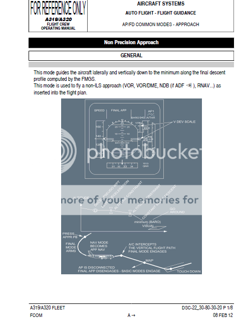
Well, then, just what would it do on a similar approach to a longer runway, i.e., how does it generate its GS indications when there is no TERPS-developed GS data (e.g., no LPV or LNAV/VNAV) with a CNF rather than a regular FAF?


The glide path is computed by the FMGS.

A320FMGSnonprecapp_zps8e9e0dfa.png
 
NTSB to Hold Investigative Hearing Into August 2013 UPS A300 crash in Birmingham, Ala.

January 30

The National Transportation Safety Board has scheduled an investigative hearing on February 20 into the crash of a UPS Airbus A300-600 on approach to Birmingham-Shuttlesworth International Airport in Birmingham, Ala., on Aug. 14, 2013.
The two flight crew members were killed and the airplane was destroyed when it impacted the ground less than a mile short of Runway 18. The cargo flight had originated from Louisville, Ky. Runway 18 was being used because the main runway at the airport was closed for repairs at the time of the airplane's arrival.
The one-day hearing will examine:


  • Execution of non-precision approaches, including initial and recurrent training, adherence to standard operating procedures, and proficiency
  • Human factors issues associated with effective crew coordination and resource management applicable to this accident, including decision-making, communication, fatigue and fitness for duty, as well as monitoring and cross-checking, policies, standard operating procedures, guidance, and training provided to UPS crewmembers.
  • Dispatch procedures, including the training, evaluation, roles and responsibilities of UPS dispatchers and the limitations of dispatch-related software.

The investigation is ongoing and this hearing will develop additional facts to support the investigation. The hearing will be held in the NTSB Board Room and Conference Center in Washington, D.C. A detailed agenda and a list of attendees will be forthcoming.
Parties to the hearing will include the Federal Aviation Administration, UPS, Airbus, the Independent Pilots Association and the Transport Workers Union. The accredited representative from the French Bureau d'Enquêtes et d'Analyses pour la sécurité de l'aviation civile (BEA) will participate on the technical panels.
The determination of the probable cause of the crash will be released when the investigation is complete. Just prior to the start of the hearing, the public docket will be opened. Included in the docket are photographs, interview transcripts and other documents.
 
Back
Top