This is what you want to see...

scottd

Pre-takeoff checklist
Joined
Dec 6, 2005
Messages
117
Location
Charlotte, NC
Display Name

Display name:
scottd
.....................

....................
 
Last edited:
they issued a watch yesterday about the same time about the same area, also before the first radar returns. yes, a very good thing.
 
that cell up in SW kansas between Ulysses and Liberal just generated a Tornado warning too. Western half of KS in a Tornado watch.
 
My plane is hangered one county outside the marked area and unless Mother Nature has a different idea, it will stay in that hanger until this mess passes.

Doc
 
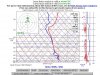
You'll want to pay attention right around the Lawton, Okl. region where the first line of convection will likely develop...

Damn, Scott, you were right on...that's exactly what happened. :yes:
 
Wow, It certainly looks like it will be making noise here at my house tonight.... again :rolleyes:.

Lots of storms keep coming through here. We had one a few weeks ago that produced three tornadoes in my town.

Bob
 
Here's a closeup image of the three supercells that initially erupted...

Supercells.gif

Scott- What is that perfect hole...its in the middle cell, toward the bottom of the pic (south?) and almost resembles a hurricane eye. Something similar?

And using the Vertically Integrated Liquid (VIL) product from the Ok City NEXRAD, there's likely huge hail (3"+) in the cell northwest of Ok City evidenced by the while pixels in the center of that cell. :hairraise:

VIL-OK.gif

Never seen a tornado...
 
Just saw on the news someone found a hail stone the size of a volley ball. Think it was down around Norman, I don't know if I've ever seen it rain so hard before. Most of the watches and warning are moving into the eastern part of the state. Glad I didn't get to see another EF-5. One was plenty!
 
A friend reported 1" hail and +RA in NE New Mexico from this morning til the evening. Most severe was in the AM.
 
I love seeing all the charts and stuff. Takes me back to the early 90s when I chased for Skywarn, and we had virtually zero data/tools in the field.

Always hate thinking about who's underneath all those fancy Doppler RADAR images though. Sigh.

Loved that inversion layer chart. Seriously big boom was waiting to pop there. Cool stuff.

Always loved seeing a massive dry-line setup east of Denver near Prospect Valley. Some great hills out there to get up on and watch it all go up fast late-afternoons back when I had time to do that... Kinda had to get off before the lightning started though if you were smart. Loud and bright if you dawdled.

Watching the speed of the vertical development and trying to guesstimate it by Mark 1 Eyeball was always my favorite. A good setup would just go "pop" and be topping out 35K up or more, in seemingly no time at all. Nature is impressive.
 
Looks like more tornadoes today! Hope all the recent press regarding the Joplin tornado and the activity yesterday will inspire the folks in the high risk areas to keep an eye out and groundhog it if necessary.
 

Attachments

  • tornadies.gif
    tornadies.gif
    30.5 KB · Views: 9
Last edited:
Scott, this is a fascinating exercise. Thanks for kicking it off!
 
This is what things looked like just before lunch today - the sirens were going off, and we got chased into our shelter area because funnel clouds were buzzing around southern KC:
 

Attachments

  • skewT_OJC_25May11.JPG
    skewT_OJC_25May11.JPG
    151.8 KB · Views: 18
You are welcome. BTW, did ever check on the facility in the Dallas region that would be able to accommodate my workshop?

The conference facility is a sure thing, and adjacent hotel space is also a sure thing. All I am trying to work out is whether transportation to/from the nearest airport (KADS) is convenient, or what might be arranged.

Also looking into other venues.

I know we can pull it off - only question is, where's the best place?

More later...
 
Back
Top